December 2021 Hong Kong, Mountain and Countryside Walks
November to December 2021, Hong Kong, in chronological order of walks:
Lau Shui Heung Reservoir, Hok Tau Reservoir
Fung Hang, Luk Keng, Lai Chi Wo, Kong Ha Au Loop
Old Peak Road, High West, Hong Kong Trail Section 1
Kong Ha Au, Lai Chi Wo, Sam A Tsuen, Wu Kau Tang Loop
In the crisp autumn season, it's the best time to hike in this subtropical city. Hong Kong has little flat land, and the mountainous terrain creates many different hiking routes. Although there are no towering mountain ranges, there are many diverse hills. Every weekend in November and December, I spent a day hiking. The feeling of walking like this brings fatigue mixed with the joy of sweating.
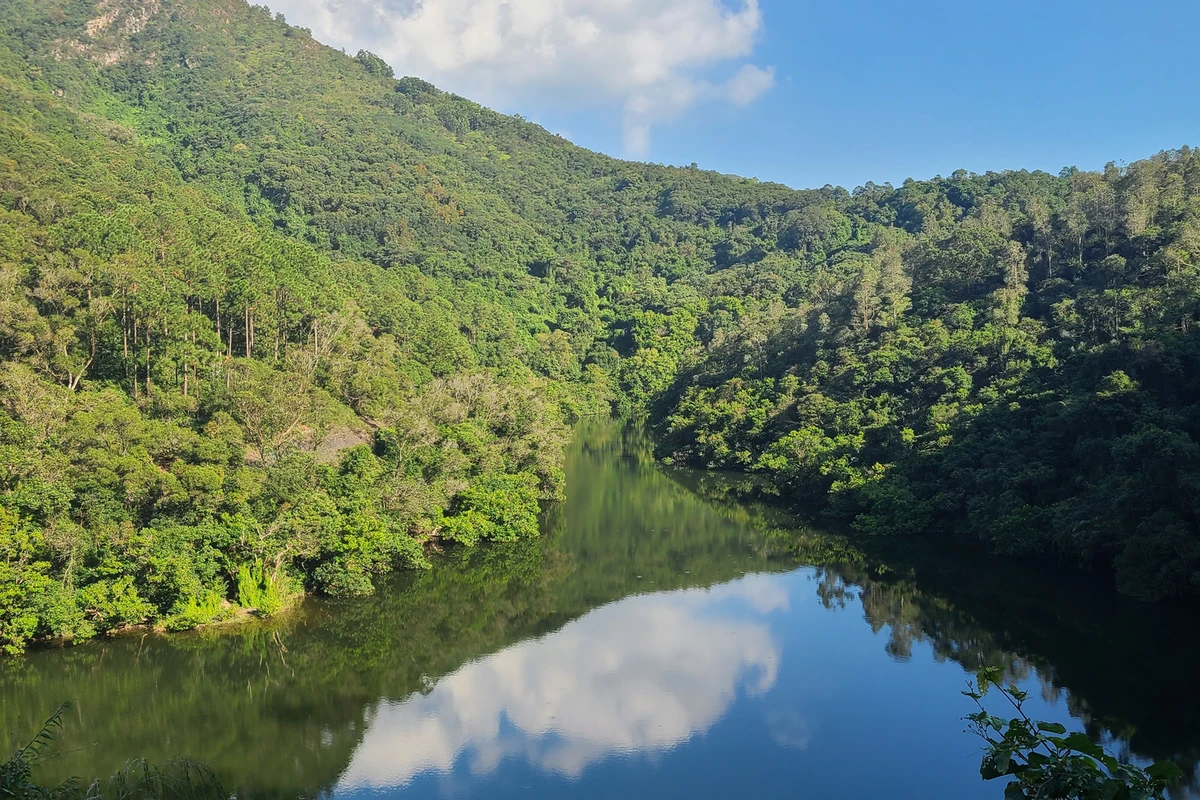
Lau Shui Heung Reservoir and Hok Tau Reservoir form a leisurely hiking route, including two reservoirs and a short mountain path. Most of the route is shaded by trees, and there are few pedestrians, allowing you to walk slowly and take in the fresh air of the countryside. Lau Shui Heung Reservoir is famous for the rows of paperbark trees (Melaleuca) along the water's edge. It is said that in deep winter, the leaves turn orange-yellow, but now they are still lush green. The calm water reflects the blue sky, valley, and trees, creating a pastoral idyll.
Most visitors stop here, but we continued along the Lau Shui Heung Country Walk. The trail is moderately maintained, with some damaged sections, but there are very few people, and we only occasionally met someone. Slowly we climbed up a sloping path. Then we connected to a short section of the Wilson Trail. By chance, we could see a panoramic view of Lau Shui Heung Reservoir from a high point, and also glimpse Shenzhen's Liantang to Luohu in the distance. From another direction, we could barely see the high-rises of Shenzhen Bay.
Continuing on, we reached the second reservoir of the trip, Hok Tau Reservoir. When we arrived, the wind was calm and the water was still, perfectly reflecting the blue sky and white clouds like a mirror. Wanting to see it from another angle, a gentle breeze blew, creating ripples on the water, and it took a long time to calm down again. Some things can only be encountered, not sought.
We walked a short distance along the reservoir, but a section of the path had been destroyed by previous flash floods, preventing us from completing a full loop around the reservoir.
To reach Tung Lung Chau, there is only a ferry, which operates only on weekends and public holidays, running between Lei Yue Mun and Sai Wan Ho. Perhaps because of this, there are always long queues of visitors on holidays. Some people choose to camp overnight to avoid the crowds. As the southernmost island of Sai Kung District, it is only a 30-minute ferry ride from Lei Yue Mun, facing Clear Water Bay Peninsula, Tseung Kwan O, and Shek O across the sea. However, the southeastern coast of the island offers a rare sight even among Hong Kong's many outlying islands: a seamless connection between sky and sea.
After landing on the island, we first had breakfast at a dai pai dong (small eatery). The value for money was not high, as all supplies need to be shipped in, but the owner was very friendly, and we were able to avoid the crowds from the same ferry. The loop around the island was not too challenging overall, especially from Nam Tong Pier to Nam Tong Summit, which was mostly concrete slopes.
The only mildly challenging part was the stairs up and down to see the prehistoric rock carvings. The carvings are on a huge boulder by the sea, and their age is unknown, but they prove that Hong Kong was inhabited very early.
After reaching the transmitter station at Nam Tong Summit, the path down to Tung Lung Fort was in poor condition, mostly loose gravel and sand in the grass, relatively steep, and occasionally obstructed by trees and grass along the way. Luckily, we were well-prepared with gloves, which allowed us to use branches and large rocks to handle the terrain easily. Especially on such a sunny and dry day, the path was relatively easy to walk. Near the campground, we saw people doing cliff zip-lining and rock climbing. The cliff zip-line involves sliding down a steel cable between two cliffs, facing a magnificent sea view, but you might not have the mind to enjoy it—it's definitely a challenge of courage and strength. However, this activity cannot be walked in; you must join a full-day tour group.
Leaving the camping area, we started the most difficult section of the day: climbing over rocks to reach the Blowhole (Tung Lung Chau Blowhole). Step by step, we descended the cliff and walked on the reef below. Around a turn, we saw and heard the spectacular Blowhole. The waves crashing against the rocks, the thunderous surf—indescribable in words. Sitting there, watching the spray from the surging waves and the rainbows forming on the rocks—each time different—I felt like I could let time flow by without care. But we had to catch the return ferry, so we reluctantly left this pleasant place.
On the way back, we saw someone coming down from another path, which seemed shorter than the one we came from. We decided to climb up that way. It was steeper, almost vertical, but with teamwork we managed to reach the top. After that, the path returned to concrete, which felt like walking on flat ground compared to the difficult sections we had faced. Before boarding the ship, we still had time to enjoy an afternoon tea at the dai pai dong near the pier. The scenery here, especially along the coastal cliffs, combined with the azure sky, made me forget I was in Hong Kong. No wonder so many people come to this outlying island to relax on weekends.
Ng Tung Chai Waterfalls: a hiking trail consisting of four waterfalls on the northern mid-slope of Tai Mo Shan. Perhaps because it's near Hong Kong's highest peak, or because it's deep in the forest, or because we set off after noon, the entire path was somewhat dark and secluded. Even under the clear autumn sky, not much sunlight penetrated. Also, because the path runs close to a stream, even after several rainless days, the trail was a little slippery.
At the beginning, the path was almost entirely stone steps, irregular and narrow in places—barely enough for one person—with many turns, and beside the turns were steep slopes. As we started climbing, there was little scenery in the dense forest, only the sound of flowing water. For nearly half an hour, it was all stone steps, almost exhausting all our energy.
Fortunately, we soon reached the Bottom Pool Waterfall. We had to descend a short distance on the mountain path to see the waterfall surrounded by trees and rocks. To see it properly, we had to stand on the left side of the pool; it actually consists of three layers of water.
Continuing up the steps, in just over ten minutes we reached the Middle Waterfall, where the flow widens. In fact, this is the top part of the waterfall seen from the Bottom Pool.
Leaving these two waterfalls, we continued up slightly harder stone steps. Near the Main Waterfall, there is a small waterfall hidden among the trees, but compared to the main one over 30 meters high, many people overlook it.
With stops and starts, we finally reached the longest waterfall in Hong Kong. For a place whose highest point is under 1,000 meters, this is truly rare. Moreover, in late autumn, the water volume was still considerable. Due to the height difference, the water fell in a slender stream. The rocks beside the pool were more or less wet from the falling water, making them slippery.
Crossing the pool and continuing uphill, we headed to the last waterfall of the group, the Scattered Falls (or Dispersing Waterfall). The path here was more treacherous, but newly built railings made it feel dangerous but safe. Here the water flows down along the rock face like flowing long hair, hence the name.
Turning around to look into the distance, we saw a basin surrounded by different hills: the flat Pat Heung and Kam Tin areas, and even Shenzhen in the distance. We then chose another path to descend, which was clearly easier than the one near the waterfalls. It passed through a long bamboo grove, but unfortunately, it was getting dark, and there were no outstanding sights.
From Luk Keng to Wu Kau Tang, the introduction seemed simple, so I didn't wear hiking shoes. That turned out to be a mistake. The trail wasn't bad, but walking in ordinary running shoes was very uncomfortable. The path was made of variously shaped large stones that easily tripped you up, especially on the mountain path going up and down the watershed.
To get a free parking spot, we left early in the morning, but parking wasn't easy either. There were many cyclists on this route, and many of the parking spots were probably taken by their vehicles. Eventually, we found a spot near Fung Hang Family Walk, which was quite a distance from our planned start and end points.
Walking along the Family Walk, there was an inconspicuous viewing platform overlooking the entire Yantian District. I must say, the difference between Hong Kong and Shenzhen in the border area is really stark. From Luk Keng to Kuk Po, we were circling the Sha Tau Kok Sea, with Sha Tau Kok and Yantian on one side—towering high-rises on one side, and only two- to three-story village houses on the other. Which one is the Pearl of the Orient?
Along the coast, there were many mangrove mudflats, but the most extensive mangrove area was at Lai Chi Wo, with a boardwalk through the mangroves to observe the ecology of the mudflats up close. In places without many mangroves, seabirds were foraging, creating beautiful reflections on the rippling water. After passing through the mangroves at Lai Chi Wo, there was a viewing platform where you could climb up and take in the whole bay.
Lai Chi Wo has a pier, making it the most crowded spot on the entire route. The villagers were very business-savvy, occupying almost all the places where visitors come and go.
To avoid walking in the dark, we left the coast here and started the return trip. So the planned loop from Luk Keng to Wu Kau Tang had to be interrupted midway. Because early sunset in late autumn, we started a rush mode. The problem of not wearing hiking shoes became more obvious. Fortunately, most of the path was dirt mountain trails. In the dry autumn, the sneakers with almost no grip could still manage. Walking through the hills as the autumn sun gradually set was still a pleasure. At the highest point of the route, the Wu Kau Tang Country Walk viewing platform, we could overlook most of Plover Cove, which was the highlight of the return journey.
On the way back, we encountered several herds of cattle, sometimes blocking the path. Naturally, we also had to avoid cow dung on the ground throughout.
Although we walked for six to seven hours, it wasn't too tiring. Especially on slightly cool autumn days, the mountain breeze could blow away troubles.
From Central, through the Zoological and Botanical Gardens, up to The Peak, then to High West, and finally down to Chi Fu Fa Yuen. This was a path both familiar and unfamiliar. I had walked from Central Mid-Levels up Old Peak Road many times since my first accidental walk in 2007. I was very familiar with this all-slope road, but I didn't know that the location mentioned in the lyrics of the song "Fen Li Dao Shang" was right near here. The Peak Tram station was temporarily closed, so I couldn't capture the beautiful view of the tram with the mountains and sea.
Though it sounds like a long distance, in less than an hour we reached the Peak Tower from Central. Many things you only truly know and understand when you try them yourself. Without stopping at the Peak Tower, which I had lingered at many times, we headed directly to High West. I had walked along Lugard Road several times but never noticed a small path hidden in the woods leading to High West.
The normal route up and down High West is 500 steps, not too difficult, just crowded because the path is narrow.
The first time I went up High West, I was amazed by the panoramic view overlooking the entire central and western parts of Hong Kong. I couldn't help feeling a vague sense of emotion. But perhaps because the route is easy, this small summit was a bit overcrowded.
When we returned from High West to Lugard Road, I felt we hadn't walked enough today, so we continued to Pok Fu Lam Reservoir. Unfortunately, this stretch basically went along the hillside behind the reservoir, with dense trees, and only occasionally could we see the water surface through gaps in the forest.
The winter sun sets early. As we approached Chi Fu Fa Yuen, we were attracted by the dusk scenery and stopped at a spot where we could barely see the sea and mountains connecting. Waiting was worth it to see the egg-yolk-like sunset.
Then we walked Dragon's Back again. I've lost count of how many times I've walked this eighth section of the Hong Kong Trail. Every time, I start from Lung Yick Road in Siu Sai Wan, but each time I have a different feeling. Before, I would start climbing as soon as I arrived. This time, I discovered that the seaside promenade outside Island Resort has a nice view. Under the winter sun, the shadows of the tall buildings on the Blue Bay Peninsula fall into the blue sea, creating a deep blue patch that at first glance seems like a clear change in the color of the seawater.
It was the first time I walked this section in the afternoon. In my blurry memory, many times before, the sun was covered by clouds, making the scenery seem misty. This time, the sun hung alone in the sky with hardly any clouds, but at the horizon where sea meets sky, it still felt hazy. But that didn't affect the clear view of the beautiful scenery at the foot of the mountain.
After finishing the uphill Lung Yick Path and reaching Tsing Fung Path, there was a stretch of nearly a thousand stone steps to climb continuously. If you keep your head down and hurry, it might be boring, but along this section, if you look back from time to time, you can see the sea view between Siu Sai Wan and Tseung Kwan O through the trees. There is also a viewing platform partway that helps reduce fatigue with the scenery. After climbing all the steps, Cape Collinson embraced by the mountains on the sea surface serves as a kind of appetizer.
After a long stretch of level concrete path, we saw a sign pointing to Dragon's Back. The path then turned into yellow soil mixed with gravel. From Cloudy Hill to Shek O Peak, the undulating ridge gives it the name Dragon's Back. This is also the best scenic route in eastern Hong Kong Island. The clear water and fine sand of Big Wave Bay Beach, the red-roofed cottages of Shek O Golf Club that look like they're in Europe or America, and the panoramic view of Shek O Peninsula embraced by Tai Tau Chau and Ng Fan Chau—all these sweep away the fatigue of hiking.
The sun was getting lower westward, giving the vegetation-sparse path a golden coating. As we approached Shek O Road at the foot of the mountain, it was near dusk again, so we decided to wait for another sunset. Watching the sun from blinding brightness to sinking between mountains and sea always leaves me in awe of nature's beauty and wonder. But unfortunately, today the sky was almost cloudless, and the sunset scene lacked a magnificent finale.
Hong Kong has three steep peaks known as the Three Sharp Peaks (Hong Kong Three Sharp Peaks). One of them is High Junk Peak on Clear Water Bay Peninsula.
To conquer High Junk Peak, you need to be well-prepared. Gloves indeed helped us overcome the relatively complex terrain many times. When we set out, it was mostly cloudy. Although near the starting point we could see the sun's shadow above the clouds, it couldn't penetrate the morning mist, making the early climbing views—whether of Clear Water Bay or Tseung Kwan O—shrouded in a grayish tone.
We left the High Junk Peak Country Walk and turned onto the summit path. After passing through several bamboo groves, as the sun slowly rose, sunlight finally began to break through the clouds. Although it didn't create a clear blue sky, it reduced the mist, and the scenery began to clear. After passing the hill of Miu Tsai Tun, we saw the pointed summit of High Junk Peak and the faintly visible climbing path. With the support of gloves and roadside trees, the ascent was not too difficult.
When we reached the top, the sun finally completely broke through the mist and shone upon the land. From this sharp peak, we could enjoy a 360-degree view of Clear Water Bay Peninsula: Tseung Kwan O, Clear Water Bay First and Second Beaches, Po Toi O, and the southernmost tip of the peninsula—the Clear Water Bay Golf and Country Club. This eastern coast of Hong Kong connecting to the South China Sea is undoubtedly the most eye-catching. Along the way, any relatively flat spot with a sea view naturally becomes a photo spot.
Leaving the summit, we returned to the High Junk Peak Country Walk. From here on, gloves were no longer needed. After descending for a while, we had to go up again over Tin Ha Shan (which is lower and less steep) to reach the foot of the hill near Po Toi O village. Just when we thought this section had no more surprises, we discovered several huge boulders accessible on foot at different spots, each offering a different view. Some served as platforms to sit on quietly and watch the sea and sky merge; others acted as bases for climbing higher to look far into the distance; still others had unique shapes that complemented the scenery differently.
In short, we lingered and didn't want to leave on this downhill path around Po Toi O and the golf course. The seawater in the distance, under the combined effect of varying depths and sunlight, displayed different shades of blue. It gave me a feeling somewhat like seeing coral reef islands in the ocean. Before we knew it, we returned to the road, and then entered Po Toi O village, which I had only heard about but never seen. Unfortunately, when you look at this bay at eye level, it lacks the stunning effect from above.
We completed the missing section of the Wu Kau Tang to Luk Keng loop. Even though we set off at 8:30, we couldn't find a parking spot at Wu Kau Tang, so we started from Kong Ha Au towards Lai Chi Wo. This entire section was the same route as when we left last time. However, after several days of rain, the familiar trail had become slippery, especially on exposed rocky sections, requiring extra caution.
In less than an hour and a half, we reached Lai Chi Wo. The number of hikers had been manageable so far, but upon entering Lai Chi Wo, we could feel the power of the long holiday. This area is already the most popular gathering spot in the region, and the density of people increased again. Even the viewing platform at the small beach, usually unnoticed, was crowded with people.
The road ahead still had many surprises. Although the section from Lai Chi Wo to Sam A Tsuen had few coastal stretches, there was still unique geological features to experience. There were many red sedimentary rocks here, composed of red sandstone, conglomerate, and breccia from the Late Cretaceous period. They belong to the same type as Danxia landforms. Their reddish color is due to the oxidation of iron in the rocks under dry climate conditions. Since the Cenozoic Era, tectonic subsidence and sea level rise have created a bay-linked inner sea environment surrounded by many islands. The entire northeastern coast of the New Territories bears more or less these red traces.
Walking among these mangroves and red sedimentary rocks, although the seaside sections were few, was full of enjoyment. After passing Sam A Chung campsite, the path entered the forest, but the entire route was still relatively gentle, making it very comfortable to walk. Especially breathing in the abundant negative ions from the trees, and with the Miu Shek Shek Stream along the way, we could hear the sound of water flowing over rocks, very pleasant. This section also passed two villages engulfed by trees: Sheung Miu Tin and Ha Miu Tin. After the villagers moved out in the 1960s and 1970s, the original houses were gradually covered by trees. Walking on the former village roads, we could no longer find traces of houses.
At the end of the journey, near Kau Tam Tso, not far from Wu Kau Tang, we encountered a patch of red leaves. Although the number of trees that changed color was small, the leaves of several trees had turned mostly orange-red, standing out vividly amidst the lush green mountains, attracting many visitors to linger.
Hiking across Pat Sin Leng, the entire route basically goes from sea level to the summit and back to sea level. It includes eight peaks named after the Eight Immortals, and passes through eleven named peaks in total. The highest is Wong Leng at 639 meters, and the lowest is Choi Wo Fung at 489 meters. Starting from Hok Tau Reservoir, the clouds had not fully dispersed at the beginning, and the sunlight couldn't shine on the reservoir. We quickly passed the mirror-like water surface. But at this time, the clouds were actually the most beautiful, scattered in clumps.
From the concrete path beside the reservoir, we turned onto the Wilson Trail and began climbing steps. For the next two kilometers, we were climbing stone steps, ascending over 500 meters in elevation. When we passed by the summit of Ping Fung Shan, this arduous uphill stair section finally ended. The path after that, though with some ups and downs, varied within about 100 meters vertically.
At that moment, we encountered workers repairing the path. We were only carrying backpacks with a few bottles of water, and we were already sweating profusely. These workers have to carry tools and climb the mountain every day, working under wind and sun. They are the unsung heroes who enable this mountainous international Asian metropolis to have both so many skyscrapers and hiking trails. This ridge route offers great views: to the north, you can see Sha Tau Kok and Yantian; to the south, there is a valley surrounded by mountains on all sides, resembling a Swiss glacier—of course, there are no glaciers in Hong Kong, nor such great elevation differences, but it still gives a sense of grandeur.
When we reached the top of Wong Leng, we had a panoramic view of Plover Cove Sea and Plover Cove Reservoir. It was a pity that mist filled the sky, blurring the scenery. After crossing Lai Pei Shan, which descends nearly 100 meters, there were scattered patches of silver grass along the way. Although not dense enough, the background of mountains and sky completed the picture.
Facing us was a peak with staggered ascending stone steps and steep cliffs—this was the main peak of Pat Sin Leng, Sheung Yeung Fung.
Looking back at the path we had come, I couldn't help but feel amazed by the ups and downs we had traveled. Looking forward, we could see the other seven peaks of Pat Sin Leng. At this moment, I understood more deeply the saying, "I only know that I am in the midst of the mountain." When looking at Pat Sin Leng from elsewhere, the eight undulating peaks are always distinct, but now from the main peak looking east, they were indistinguishable.
This section of about one kilometer, walking up and down among these hills, was delightful.
Indeed, due to geographical advantages, the peaks with the best views are the highest western Sheung Yeung Fung and the easternmost Ko Yeung Fung. Although the mist in the sky grew heavier, making the dam of Plover Cove Reservoir almost disappear into the haze, the fjord between the two mountains remained stunning.
Leaving Ko Yeung Fung towards Tai Mei Tuk for the descent, the steps were relatively gentler compared to the uphill stone stairs. However, the entire descent was mostly shaded by trees, making it less scenic. Especially when connecting to the Pat Sin Leng Nature Trail along the hillside, there wasn't much outstanding. The only benefit was that the sunlight was blocked by the forest canopy, though some sections of rock were still slippery and required caution. Finally, we returned to sea level at Tai Mei Tuk. Walking among these rolling hills, one can basically take in the entire northeastern New Territories scenery. The physical effort and sweat are all worth it when you climb high and look into the distance.
"As Heaven's movement is ever vigorous, so must a gentleman ceaselessly strive for self-improvement. As Earth's condition is receptive and yielding, so must a gentleman cultivate virtue to carry the outer world." May we always walk without borders, and have a heart without hindrances.