2022-06 Hong Kong, Mountain Hike II
January to June 2022, Hong Kong, in order of hiking time:
Pak Tam Chung Nature Trail, Sheung Yiu Country Trail
Sheung Yiu Country Trail, Po Kwu Wan
Lau Shui Heung Reservoir, Hok Tau Reservoir
Sai Kung Sai Wan Road, MacLehose Trail Section 2
Kwu Tung Reservoir, Ki Lun Shan
Entering 2022, the pandemic situation in Hong Kong became more volatile, especially during the period of February to March, when new infection numbers hit new highs every day. It calmed down a bit in May, but by June the number of confirmed cases started to increase again. Stuck in Hong Kong, I had no choice but to continue immersing myself in the mountains. The spring rains were not heavy this year, but due to the recurring pandemic, the number of hikes greatly decreased. During some months, even one hike was considered good.
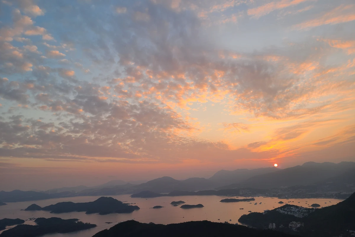
The start time for climbing Tai Tun was very late, not until High Tea Time at 3:30. We arrived at Pak Tam Chung, and when we were ready, it was nearly 4 pm. The path from Pak Tam Chung up Tai Tun was basically a trail forcefully carved through the bushes, not a maintained path. Besides the mix of gravel and mud, the steepness was also considerable, climbing from sea level to the summit at 317 meters in about 1 kilometer. Although it was in the jungle, the vegetation was not tall enough to block the sun; instead, low branches became obstacles. During the climb, we had to occasionally use tree trunks on the side, so gloves were necessary.
After climbing over 100 meters, the view of the inner sea of Sai Kung began to appear. But such scenery was not enough for us. We took short breaks and photos along the way, then continued to the top, reaching it in less than an hour. Although not high, the summit offered a panoramic view of the islands in Sai Kung's inner sea.
The summit was relatively flat. Besides the inner sea of Sai Kung, there was also the other side of the Sai Kung mountains. We walked around the summit platform; the best view was facing the inner sea of Sai Kung, which was also the direction for watching the sunset. Since we started quite late, we naturally waited for the infinitely beautiful sunset. As the sun sank, the wind on the mountain grew cooler, and the clouds in the sky increased slightly, adding more beauty to the sunset scene. Waiting for the sunset was never boring; watching the pink horizon and the egg-yolk sun, the sea and sky were both dyed red by the clouds.
After the sun set behind the mountains, we started descending quickly from the other side. The winter residual light was swallowed by darkness rapidly. Although we took only half an hour to turn from a steep and gravelly path onto the main road, by then the last light had completely disappeared. This was our first time walking in the dark; using the flashlight on our phones, we could barely see three to four meters ahead. Luckily, the terrain was not too difficult, mostly flat, with only occasional tree roots that could trip us. Finally, we connected to the Pak Tam Chung Family Walk, which was easier—all paved cement steps. In three hours total, we completed this journey with a different experience.
Tai Mo Shan is the highest peak in Hong Kong, at 957 meters dominating all other peaks. Since the summit has almost no obstacles, the highest hilltop is occupied by several radar stations, off-limits to visitors. The highest point accessible via the mountain road is 919 meters. Tai Mo Shan covers a vast area, almost the entire central New Territories. Although high, the slope is gentle, and the uphill road is relatively flat, so we hardly noticed that the car had already climbed to the parking lot at 702 meters. The climb from the car to the summit was only a 200-meter elevation gain, still on a gentle road, making the hike very easy. This is part of MacLehose Trail Section 8.
As we kept going up, only by looking back did we realize we had passed a series of hairpin bends.
Due to the special geographical environment of the mountain, the moist air brought by the sea wind easily forms clouds and fog when rising over the highlands. Even on a clear winter afternoon, there were still some clouds lingering. As the sun slowly set from a high point, the clouds and fog on the horizon became even more rampant. Normally, one could see most of Hong Kong's land from here, but even nearby areas like Kam Tin, Pat Heung, and Tsuen Wan were shrouded in mist, appearing faint and indistinct. Perhaps this is why it is also called Da Wu Shan (Big Fog Mountain).
Near the parking lot, there is also a road leading to the Tai Mo Shan Youth Hostel, the highest-altitude youth hostel in Hong Kong. Located in the mountains above 600 meters, both the feeling and the climate are completely different from this ocean-influenced subtropical monsoon city dense with skyscrapers. Halfway to the hostel, there is a stream that can barely be called a waterfall. As the highest point in Hong Kong, Tai Mo Shan is the source of many water systems, but although we didn't expect to see any magnificent waterfalls in Hong Kong, we were still disappointed.
Pak Tam Chung Nature Trail runs along the river, with a unique ecosystem where salt and fresh water meet. The mangroves by the water might have interesting animals. But we didn't encounter any; we only saw cattle grazing leisurely by the roadside.
The end of this trail is the Sheung Yiu Folk Museum, but unfortunately it was temporarily closed, so we couldn't get a glimpse of this other side of history. Sheung Yiu Village was a Hakka village built in the late 19th century. The villagers had long moved to the urban area, and the whole village was abandoned. The only remaining building is this Sheung Yiu Folk Museum, converted in 1984 from a traditional Hakka house, open to the public to show the history of Sheung Yiu Village and the lime kilns.
Another remaining building is the Chapel of the Seven Sorrows of the Virgin, built in 1900, but it seems no longer open to the public. We climbed the steps and connected to the Sheung Yiu Country Trail. Most of this trail is covered by bushes along the cliff, with only a few turns revealing the islands in Sai Kung Sea. It's basically a view of scattered islands at the same level, indeed not as beautiful as looking down from Tai Tun.
Near the end, we could see the West Dam of High Island Reservoir from another angle, but the dam body looked like a pile of earth, not impressive. The country trail was mostly gentle yellow soil paths with little elevation change, less than 100 meters, making it an easy walk, but the scenery was not particularly captivating.
Then we connected to Sai Kung Man Yee Road, which was easier to walk on concrete. Over 8 kilometers were completed in two hours, a simple hike. As we were about to leave the reservoir, we noticed the water level seemed quite low compared to the water marks on the mountain. Hong Kong's water shortage problem seemed to have receded since the introduction of Dongjiang water, but it doesn't mean fresh water is inexhaustible.
A circular hike: starting from Luk Wu Country Trail, turning onto Tai Cham Koi, crossing the ridge to Sai Kung Man Yee Road, and finally back to Pak Tam Chung. Tai Cham Koi is the second highest peak in Sai Kung East Country Park, at 408 meters. To the south, you can overlook the entire High Island Reservoir and the inner sea of Sai Kung around Kau Sai Chau. But we came here for the hanging bells (Fuchsia) flowers. Since the flowering period is generally from late January to early February, mostly around Chinese New Year, we met quite a few flower-viewing visitors along the way. The weather had been unstable for the past few days; the sun was rarely seen, always blocked by thick clouds, let alone blue skies. Occasionally there were brief showers. On the way to Sai Kung that day, we also encountered light rain and almost changed our plan. Fortunately, when we arrived at Pak Tam Chung, there was no rain and the ground was dry, but clouds and mist hung over the low hills, obscuring the peaks. The stone steps at the start of Luk Wu Country Trail were very slippery due to several days of rainy weather, especially where roots were exposed. But this was the most slippery part of the entire trail, proving that ordinary hiking shoes struggle to provide enough grip on wet stone steps.
After that, most of the path was dirt, which was much less slippery than stone steps. Moreover, the higher we went, the drier the path became. When we turned onto the climb up Tai Cham Koi, we began to see hanging bells scattered among the mountains. The pink flowers hung downwards, with dew clinging to petals and branches, making them appear crystal clear.
Searching for beautiful flowers in the wilderness was a pleasure; we kept climbing and admiring the flowers, almost forgetting our fatigue. As the altitude increased, fog surrounded the entire hilltop with the mountain wind, bringing a damp chill. When we reached the summit, the fog turned everything into a white expanse; we couldn't even see the High Island Reservoir at the foot.
We started descending toward High Island Reservoir. The first section of dirt path was slightly steep, but the surface was dry, so walking slowly was stable. However, the number of hanging bells decreased significantly here; we walked a long way before seeing one or two. But as we descended, the fog began to clear, and there was even a brief moment of sunshine, making the views of High Island Reservoir and the inner sea of Sai Kung clearer.
On previous hikes, we had left via Man Yee Au. This time we decided to walk along Man Yee Road first. There had been little rain recently, so the water level in the reservoir was noticeably lower than before, exposing some sandbars along the edges. Although the sky was not ideal—mostly cloudy—the lack of glaring sun made the hike less arduous. Besides, it was a holiday, so taxis to and from High Island Reservoir were coming and going incessantly. When we reached the Yuen Ng Fan Lookout, we could see the full view of High Island Reservoir, but the wind was very strong there, especially near the reservoir side, almost blowing us off balance.
We turned onto Sheung Yiu Country Trail, then at a fork headed toward Nam Fung Wan Campsite. At the campsite, the well-maintained country trail ended, and we had to follow a path through dense forest with little undulation, but the dense trees required constant attention to head and feet.
After nearly an hour on the small path, we finally reached the highlight of the day: the crescent-shaped embankment at Po Kwu Wan. This was part of the abandoned Kai Tsz Wan Village. The former villagers used it for trapping seafood. The once complete embankment now has three gaps, said to be original sluice gates. The super typhoon Mangkhut in 2018 completely destroyed the already shaky gates. As more and more visitors come, the unrepaired embankment may eventually collapse completely. Unfortunately, the wind didn't die down and the sky was too gray, causing ripples on the water inside the embankment, diminishing the mirror effect that could reflect the sky. Still, many visitors sat quietly on the embankment, experiencing the movement and stillness of Sai Kung Sea. On both sides of the embankment, we could see many fish swimming in the still clear water.
We only stayed a short while; there were too many people, ruining the tranquility. We continued toward Kai Tsz Wan Village, where the path improved quickly, and soon we reached the Sheung Yiu Folk Museum. Last time it was just closed; this time it was under renovation, surrounded by scaffolding.
Today the water level was very low. Walking along the Pak Tam Chung Nature Trail beside the stream, we found a stone beach exposed. The green of the stream contrasted nicely with the emerald leaves of spring. Reflected in the water and sky, there was a hint of the charm of Jiuzhaigou's Haizi.
Second visit to Lau Shui Heung Reservoir and Hok Tau Reservoir. Compared to the previous clear blue sky and white clouds of autumn, the sky was gray this time, dulling the green mountains and clear water. But during the holiday, visitors' enthusiasm was not affected by the weather. Lau Shui Heung Reservoir was almost packed with people, and the road was lined with cars, making the originally tranquil reservoir too lively.
We left the crowd and took the Lau Shui Heung Country Trail; a few steps in, there were almost no other hikers. We climbed uphill without the scorching sun, but lacked a refreshing breeze. Only at the summit or on windward slopes did we feel it.
Arriving at Hok Tau Reservoir, separated by just one mountain, there were far fewer visitors, probably because it was getting late and most had left. For lake and mountain scenery, clear weather is still very important.
Third walk on MacLehose Trail Section 2, second time passing Sai Wan Pavilion. We experienced the scorching sun for 6-7 kilometers from Pak Tam Chung to Sai Wan Pavilion, endured two bouts of heavy raindrops, and enjoyed the comfort of sitting by the sea. Even on a familiar road, there were different scenes. To avoid failing to catch the village bus from crowded Sai Kung town to Sai Wan Pavilion during the holiday, we decided to start from Pak Tam Chung parking lot and walk along Sai Kung Sai Wan Road to Sai Wan Pavilion. Unlike Sai Kung Man Yee Road opposite High Island Reservoir, this narrow road had no sidewalks and no roadside trees. The weather was good, the sun blazing. We chatted and complained about the unreliable weather forecast, and before we knew it, we had climbed the road to Sai Wan Pavilion.
Perhaps because we hadn't walked this road for too long, we forgot whether it was all uphill. At least today, the entire way from Sai Wan Pavilion to Pak Tam Au was like that, except for a sandy section at Ham Tin. Descending from Sai Wan Pavilion toward Sai Wan, trees began to provide shade, but clouds gathered rapidly, and by the time we reached Sai Wan, there was no blue sky left. At the beachside store, we bought an expensive sandwich but could occupy seats facing the sea. With the sea breeze and the sound of waves, it was easy to fall asleep. Unfortunately, we still had a long way to go, otherwise we could have sat there for half a day. The sand on Sai Wan Beach was still soft and fine, but a lot got into our mesh hiking shoes.
Near Ham Tin Wan, the weather worsened, and light rain started. We didn't cross the beach but followed MacLehose Trail, only to find this section was an inconspicuous path in the sand. If we hadn't walked it ourselves and seen the MacLehose Trail markers, we wouldn't have noticed it was a path. The rain intensified, forming large round dots on the sand. We hurried through the sandy area to reach the cement road to Ham Tin Wan, where the rain eased. We decided to visit the wooden bridge on the beach, almost a landmark. Perhaps due to the unstable weather forecast, there were fewer visitors than the previous two times, giving us a chance to walk across the bridge alone.
We had wanted to visit the store and try the advertised Turkish beer, but the owner wasn't there, so we continued.
Crossing Tai Long Au, by then the rain had mostly stopped, or the surrounding trees blocked it, so we hardly felt its effect. The pier at Chek Keng was still abandoned, contrasting sharply with the newly painted YHA opposite. But that didn't seem to affect the remaining villagers' experience of the sea. At the best seats of the beachside store, two elderly men were drinking beer from glass bottles, chatting about past sentiments or today's scenery—anyway, it was utterly carefree, seemingly unrelated to the dilapidated village behind.
Leaving this comfort, we had another two kilometers of climbing to reach the day's end point, Pak Tam Au. But at that moment, even through the dense leaves, we could hear raindrops hitting them. The rain grew denser and heavier. Fortunately, most was blocked by the trees above, with only a little falling on us. Only when we stepped onto Pak Tam Road did we truly feel the intensity of the rain.
A day hike repeatedly hindered by rain. When we set out early in the morning, the weather in Kowloon was still ideal, even a bit too hot. The closer we got to Tuen Mun, the worse it became, with more and more dark clouds gathering. After breakfast, it poured. We wandered around a just-opened shopping mall for half an hour until the rain stopped and the sun showed a little patch of blue. So we restarted our planned Tuen Mun Trail hike. Starting from the end of MacLehose Trail, this section of Tuen Mun Trail overlaps with it, climbing up steps with yellow railings and country park signs. Speaking of which, having been to both the start and end of MacLehose Trail, could it count as having completed Hong Kong's longest hiking trail?
After climbing a long set of stone steps and seeing the entrance to Tai Lam Country Park, the Tuen Mun Trail and MacLehose Trail diverged. Our goal today was the Rainbow Railing section of Tuen Mun Trail, so the country park was not our direction. The natural scenery of Tuen Mun Trail is not outstanding; most of it is in the woods. The Rainbow Railing section is the most open scenic part. Perhaps for this reason, the railings are painted in various colors, hence the name. Leaning on the railing, enjoying the mountain breeze, looking at the panoramic view of Tuen Mun and the Castle Peak behind, it was quite pleasant. But then dark clouds began gathering again from behind, and we still had some distance to cover.
We continued along Tuen Mun Trail, then turned uphill at the junction at Mong Yue Kwok, another long set of stone steps, but also the last uphill section of the day. The viewpoint near the summit was mediocre, too blocked by green vegetation, still showing Tuen Mun town, not as good as the view from Rainbow Railing. The descent was very good until we reached the signpost for Fu Tei Country Trail, after which the path became a bit rougher.
Passing through Fu Tei Barbecue Area, we continued along the road, not far from the dam of Lam Tei Reservoir. This is a funnel-shaped irrigation reservoir, wide on one side and narrow on the other, giving a slight feeling of water passing through many mountains, but the scenery was not impressive, especially the overhead power lines that marred the view. However, we encountered a rare red dragonfly, adding some fun.
Leaving the reservoir, we walked along the road toward Lam Tei Main Street, where there were several wall sections covered in murals. These walls belonged to a triangular village house. The murals covered many different themes. Although just a few walls, they were enough to linger over. One wall in a narrow alley was less complete, with many outlines not yet painted. I believe everyone can find something in these murals that resonates.
Half-day hike, not difficult, less than 6 kilometers. With such convenient transport, it's a worthwhile place to visit.
Since June, Hong Kong had hardly a single clear day. The Dragon Boat rains were indeed powerful. Over the past two weeks, yellow rainstorm warnings were frequent, even red ones at times, with dark clouds and heavy downpours. Only in the latter half of this week did things change, with brief pauses between short heavy rains, mostly cloudy, though still substantial rainfall. The long-planned "Hong Kong Heart" route finally set out on this rain-free weekend morning, even though there were still traces of last night's rain. The so-called "Hong Kong Heart" is a GPS track in the shape of a heart on Hong Kong Island. About one-third is mountain trails, one-third is sidewalks beside expressways, and one-third is urban street walking. The total length is over 20 kilometers, but mostly urban roads, so overall not too difficult. On a weekend morning when the city was not yet fully awake, we crossed the harbor to Wan Chai, still quiet. After a simple breakfast, we started from Southorn Playground. For the first time, we learned and tried to climb up to the Mid-Levels area via Wan Chai Gap Road, a path hidden next to the Old Wan Chai Post Office, a white building blending Chinese and Western styles, the oldest surviving post office building in Hong Kong.
Almost the entire way was sloping, slightly less steep than Old Peak Road, but in the gradually humid June, we started sweating profusely before long. Although mostly cement surfaces, some old sections with moss were slippery after half a month of continuous rain. Yet overall not too difficult. Following this road from sea level to nearly 300 meters at Wan Chai Gap, we accidentally discovered a path called Holland Trail, marked with a windmill.
Crossing Stubbs Road, we entered Aberdeen Country Park. Passing a section of cement Aberdeen Reservoir Road, we climbed a short set of stone steps to connect to Hong Kong Trail Section 3. As a maintained hiking trail, this was the worst section of the entire route. Days of rain had turned the yellow mud trail into a muddy mess, with many puddles of mud and water. The path was narrow, and in many places we had to step directly through these puddles, as the mountain side was covered with leaves, making slipping inevitable even with hiking shoes. Such conditions persisted until we turned onto the stone steps leading to Tin Wan Estate, leaving the Hong Kong Trail. So although we had decent hiking shoes, we had to walk slowly, despite the gentle undulations. The poor trail conditions, however, were compensated by the rain, which brought out many mushrooms along the way, some with quite large caps, adding interest. The small streams we crossed had decent water flow. We had originally planned to take a wild path up to Tin Wan Shan midway, but the condition of Hong Kong Trail made us give up that challenge. Even so, our shoes became the biggest victims.
When we reached Tin Wan Estate in Aberdeen, our shoes were caked in black mud, and even our socks and pants had plenty. It took quite some time and wet wipes to clean them mostly, restoring our hiking shoes to their original appearance. Leaving Tin Wan Estate, we turned onto relatively dull Pok Fu Lam Road, walking along the sidewalk beside the expressway. Occasionally, we could see sea views as a distraction, all part of luxury residential vistas. Along the way, we passed Bethanie, a pure white neo-Gothic chapel, the only one of its kind in Hong Kong. Although we couldn't enter due to the pandemic, peeking through the gate gave a slight feeling of being in Paris.
Continuing downhill, there were also many buildings of the University of Hong Kong. As Hong Kong's top university, it blends into the city, lacking a campus atmosphere. From the stairs next to Belcher's Garden, we reached the area near Shek Tong Tsui. Most of the heart shape was formed. At this point, my Lu, who had missed the first half due to lack of hiking shoes, joined us, creating a seagull with wings spread. After a tea restaurant afternoon tea and a short rest, we set off again. Just as we entered Des Voeux Road West, we encountered the heaviest rain of the day. Even with umbrellas and overhead cover, we couldn't escape the downpour. Fortunately, it only lasted about twenty minutes. By the time we entered Ko Shing Street, the rain had stopped. This section of Des Voeux Road West was lined with dried seafood shops, making us smell like the sea. Starting from Ko Shing Street, we wound our way uphill toward the Mid-Levels in Central and Western District, passing many stair streets. These stair streets separate the bustling commercial areas from the upscale residential zones. Looking back from the top of these stair streets gave a unique feeling.
Along the way, there were many historic buildings in Hong Kong. Tung Wah Hospital, one of the oldest public hospitals since Hong Kong's founding, has been on its current site since its foundation in 1870; Hop Yat Church is the first Chinese self-governing church; the Hong Kong Museum of Medical Sciences was the first bacteriological laboratory in Hong Kong.
At the junction of Fragrant Snow Path and Old Peak Road, we started descending, passing through Hong Kong Zoological and Botanical Gardens and Government House, returning to Central, one of the most expensive land prices in the world. This section was hidden behind Central's skyscrapers and, under the rich vegetation of the Zoological and Botanical Gardens, was quite comfortable.
When we reached Central, the rest of the route was all flat, but after a long series of ups and downs, we slowed down to reduce fatigue. Passing Statue Square and Central Barracks, we arrived at Tamar Park, home to the HKSAR Government Headquarters and the Legislative Council complex—arguably the political center of Hong Kong.
Finally back in the Wan Chai area, the heart-drawing journey entered its final segment. Passing the Hong Kong Academy for Performing Arts, Asia's best performing arts institution, and the western section of Jaffe Road lined with bars, Southorn Playground appeared before us again. After nearly 6 hours of walking, 7.5 hours total time, we completed the route that drew a heart on the west side of Hong Kong Island. It was also a cultural journey to understand Hong Kong Island's history, passing through some unique aspects of this city where East meets West. There were many historic buildings worth a closer look, perhaps worth revisiting slowly.
This week, the rain finally cleared, and the sky showed blue and white clouds for a few days starting midweek. We came to see Kwu Tung Reservoir, known as Hong Kong's Heart-shaped Lake. It's an irrigation reservoir with little maintenance, so no heart shape is visible from the water surface. Plus, the wind was strong today, so the mirror effect wasn't good. The reservoir is surrounded by a ridge called Ki Lun Shan. To see the heart shape, you need to climb up for a bird's-eye view.
On the first part of the climb, looking back at the reservoir, it basically looked like a concave shape, far from a heart.
After reaching the first slope, the reservoir was out of sight, replaced by mountain views of the northern New Territories. But the mountains there are not high, the scenery ordinary, interspersed with low-rise village houses. At the western cliff and summit of Ki Lun Shan, we could clearly see the contrast between Shenzhen and Hong Kong: Lo Wu, Huaqiangbei, Futian, even Houhai and Qianhai in the distance, all with towering skyscrapers. Meanwhile, Hong Kong's Mai Po, San Tin, and Lok Ma Chau Loop had only wetlands and low bungalows.
Finally, we reached the spot for photographing the heart-shaped lake. The ground vegetation there was trampled flat. From above, it indeed resembled a heart shape. With the distant mountains and clouds on the horizon, it was almost an ink painting. Although the scenery along the way was not outstanding, we accidentally caught the soft light just before evening, with the reservoir lit from the front, making the trip worthwhile.
After that, the descent was very short. So if you just want to take a photo, the round trip takes only about 30 minutes.
In this world, many things have so-called shortcuts. This generation focuses too much on "To The Point." Indeed, we have created more material wealth than any previous era, but what about our souls? Can this age still have the contemplation of "To Be or Not To Be"? Everything changes so fast that even taking time away from work and relationships just to be alone has become a luxury. Who still cares about and questions the essence of people and things? Hiking time might be that little bit of time to detach oneself from this rapidly changing world.