Self-driving Tour along the Hunan-Chongqing-Guizhou-Guangxi Loop, Visiting Film Locations
Exploring Fenghuang in western Hunan, taking the cable car over the Yangtze River in Chongqing; who else has crossed the Chishui River four times like me? Recalling the glories of the great leaders in Zunyi; enjoying fine liquor in Maotai, and feeling refreshed by the waterfalls; roaming along the border roads, free to go anywhere in Hunan, Chongqing, Guizhou, and Guangxi; the Eye of Heaven in the land of Chinese civilization, only our Chinese revival dream.
On July 26, when I received the admission notice from Chongqing Jiaotong University, I discussed with my child to take him to report to school, and take his grandparents along for a grand loop tour through Guangxi, Hunan, Chongqing, and Guizhou. Originally planned to depart on September 2 after sealing the league member files at school, but due to Super Typhoon Saola hitting the Shenzhen area, all expressway exits out of the city were closed, so we had to postpone to the 4th.
Day 1, September 4: Shenzhen to Sanjiang Dong Village Chengyang Wind and Rain Bridge, 724 km from Shenzhen Qianhai to Sanjiang North, toll 446 yuan, stayed at Sanjiang Banwu Yueshan Inn.
We set off at 9:30, heading straight for Sanjiang Chengyang Bazhai Scenic Area in Liuzhou. Had lunch at a service area along the way. They say the scenery of travel is on the road. From Hezhou to Guilin, the landscapes along the way were absolutely stunning. Even though it was my second time on this road, everyone in the car was still amazed, repeatedly exclaiming how beautiful it was.
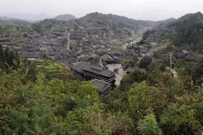
Arrived at Chengyang Bazhai parking lot at 6:20 PM. You must take a sightseeing bus to enter the village. We bought tickets at the visitor center and went in. The world-famous Chengyang Wind and Rain Bridge is located on the Linxi River next to Chengyang Bazhai. It is a national key cultural relic protection unit. Built in 1912, the Chengyang Bridge is the largest wind and rain bridge in the world and the most essential part of Dong village tourism. Among them, Ma'an Zhai, Yan Zhai, and Ping Zhai are the most exquisite. After getting off at the bridge, we crossed it and walked along the stone path, which led to these three villages. The houses here looked old, well-preserved Dong wooden buildings.
Our inn was right by the bridge. After dropping off our luggage, we quickly went to the restaurant across the way for dinner. The long journey had tired the elderly, so they went back to their rooms after eating. My wife and I then strolled along the stone path. The village was not overly commercial, and there were many art school students here sketching.
This place has been the setting for several movies, the most famous being "Skiptrace," some of which have won international awards.
Day 2, September 5: Sanjiang Dong Village to Fenghuang Ancient Town, 320 km, 4 hours, toll 200 yuan, stayed at Gucheng Tutu Apartment 10 Inn.
The alarm went off at 7 AM. The sleepy college student and grandpa didn't want to get up, so my wife and I accompanied grandma for a walk around the village, taking in the ancient scenery. The greenish-yellow rice seedlings were already bending with grain, as if welcoming us.
Time flew to 9 AM. After breakfast, we led grandpa around the Chengyang scenic area again, visiting the Dong Wood Structure Museum to learn about the construction principles of wooden houses.
After a quick tour, we returned to the hotel to pack and head to the next stop. Grandma, the young-at-heart, was very interested in the shouting fountain at the exit and played with it for a while.
We set off at 11:30, getting on the Baomao Expressway from Sanjiang North toll station. This section had many tunnels and speed limits, mostly 80 or 100 km/h. To avoid hefty fines, I drove slowly all the way from Chengyang to Fenghuang, taking nearly 4 hours for 320 km. We exited the Fenghuang expressway toll station after 3 PM. We didn't stay inside the ancient town. This time, we booked a homestay in an elevator-accessible residential area next to the Fenghuang County People's Hospital, offering a panoramic view of the entire ancient town, with stunning night scenery. A taxi to Nanhua Bridge in the ancient town cost only 5 yuan.
We had dinner on Hongqiao West Road, then walked about 1.5 km to Hongqiao Wind and Rain Bridge, starting our tour of the world-famous Fenghuang Ancient Town. The town is built against hills and beside water, with the Tuojiang River flowing through. City walls made of red sandstone stand along the banks, and South China Mountain sets off the Qing Dynasty city towers. Under the North Gate, a narrow wooden bridge with stone piers crosses the river, once a passage out of the town. The bluestone streets, stilted houses by the Tuojiang River, numerous ancient buildings, and rich ethnic customs create a unique Xiangxi flavor. It was not yet dark, so we walked downstream from Hongqiao, passing an ancient pagoda, and later in the evening admired Fenghuang's night scene from Nanhua Bridge. It was still early, and many tourists were renting ethnic costumes at shops by the stone pier bridge to take photos, happily playing the role of Miao girls.
As the lights came on, the ancient town became lively and dazzling.
We walked along the river upstream slowly to Nanhua Bridge, and by the time we arrived, it was nearly 9 PM. We took a DiDi back to the inn.
Day 3, September 6: Fenghuang Ancient Town to Aizhai Bridge to Border Town, 150 km, 2.5 hours, toll 80 yuan, accommodation in Border Town to be determined.
We spent another half day in Fenghuang. We set off at 11 AM for Aizhai Bridge. It is a super-large bridge crossing the Aizhai Grand Canyon on the Jishou to Chadong Expressway. Its main span ranks third in the world and first in Asia.
The Aizhai Highway, a treacherous section of the Xiangchuan Highway from Jishou, is 62 km long. Construction began in 1936. The horizontal distance is less than 100 meters, but the vertical difference is 440 meters, with a maximum gradient over 13%. There are 13 switchbacks, "@"-shaped turns, and sky bridges, which are ingenious designs. Over 80% of the road was cut through rock, a rare engineering feat in China, costing 200 lives. In 1937, a bronze statue of the "Pioneer" and a cemetery for the deceased employees of the Xiangchuan Highway were built in memory. The memorial tower and statue face each other, shining with the sun and moon, illuminating eternity.
Aizhai Highway specifically refers to the section of National Highway 319 from Aizhai Town in Xiangxi towards Chongqing. This road immediately climbs a steep mountain beside the town. From the foot to the top, the horizontal distance is said to be less than 100 meters, but the vertical height is over 440 meters, divided into several steep slopes with gradients of 70-90 degrees. Such perilous terrain has created a world-famous highway wonder. Originally, National Highway 319 was a frontline road built during the Anti-Japanese War over 80 years ago, then called the Xiangchuan Highway. Due to the harsh environment, difficult conditions, and tight deadlines, workers fought desperately, suffering heavy casualties. This monument was built to commemorate the 248 workers who died during construction.
The deck of Aizhai Bridge is 355 meters above the canyon floor, equivalent to over 110 stories. From the mountaintop, amidst drifting clouds and mist, it seems immeasurably deep. We drove across Aizhai Bridge. Not far after the bridge is Aizhai Bridge Scenic Area, with an admission fee of 100 yuan per person. You can go to the bottom of the bridge to experience its majesty and thrill up close. But to truly see its grandeur, you have to go to the monument for the deceased workers of the Xiangchuan Highway on Highway 319. We navigated to the Aizhai Bridge Viewpoint Farmhouse Firewood Restaurant. Walking 100 meters ahead, we reached the monument, a free viewing platform. At the restaurant, you can eat while enjoying the magnificent view of Aizhai Bridge and the sea of clouds. There's no need to spend extra money to walk onto the bridge, which would only be thrilling, not spectacular.
At the restaurant, the owner had just returned from outside and opened the door. We ordered dishes and had the owner slaughter a free-range chicken, 60 yuan per jin, quite reasonable. Then we went to the viewpoint to admire the majestic Aizhai Bridge. After playing for over half an hour, we returned to the restaurant for dinner.
We had originally planned to visit Shibadong Village, the birthplace of targeted poverty alleviation. After lunch, it was nearly 3 PM, so we gave up that idea and headed to Chadong Ancient Town in Huayuan County, the inspiration for Shen Congwen's novel "Border Town," to truly experience the scenes described in his book.
We took the Lala Ferry to feel how Cuicui's grandfather ferried people across the river back then. But now, instead of pulling the rope by hand, they use a wooden pole.
Border Town includes several attractions: taking the ferry, Cuicui Island, Hong'an Ancient Town, and Sanboguan Island. First, we took a boat ride along the river. This is the junction of Hunan, Guizhou, and Sichuan provinces. You can take a sightseeing boat. In the afternoon, we visited the spot where one foot stands in three provinces. Taking the boat cost 20 yuan per person from Chongqing, 25 yuan from Hunan, and also 25 yuan from Guizhou. First, we took the Lala Ferry from Hunan to Guizhou, which cost 2 yuan per person, experiencing a one-minute crossing between Chongqing and Hunan. Then we walked along the Nationalist Street on Chongqing Island.
Then, we spent 100 yuan on Chongqing side to take a rocking boat to the one-foot-three-provinces spot for a photo. After getting off the boat, we walked along the riverside street. The elderly and children got tired and waited by the river, while we two walked to the White Pagoda to see Cuicui's home, touring Cuicui's hut and the White Pagoda. In the evening, we ate at the inn where we were staying, ordering a pot of horned fish, slightly sour and spicy. There were many restaurants opposite Sanboguan Island to choose from, with reasonable prices. After dinner, my parents went back to rest, and we continued exploring the old streets.
There were many things like this on the bluestone slabs of the streets; I wonder if they are animal fossils.
It rained a bit after 5 PM, so we took shelter in the Chinese People's Liberation Army Westward Advance Memorial Hall, incidentally receiving some red education.
Day 4, September 7: Border Town to Chongqing Jiaotong University, 450 km, 6 hours.
Today was the day for the child to report to school. He had long asked to go to school early to familiarize himself with the environment. So after breakfast, we drove straight to Chongqing Jiaotong University.
Arrived at the Science City campus of Chongqing Jiaotong University at a little after 3 PM, and completed the registration smoothly.
After giving me a rare hug, he hurried off with his roommates to buy study and military training supplies. We left the campus with a mix of reluctance and excitement, heading to our hotel in Yuzhong District, starting the next leg of our trip.
After leaving the school, we drove 44 km, about 1 hour, to the hotel. After checking in, we had dinner at a Chongqing noodle shop next door. Then we took a taxi to the Jiangbeijiang Beach Park near Chongqing Grand Theater station to enjoy the night view of Hongya Cave and take photos. We planned to cool off there and admire the glittering lights across the river. Unfortunately, the park was closed due to wind and rain, so we couldn't enter. We had to slowly walk back, crossing the Qiansimen Bridge to Hongya Cave to see the night scene.
Hongya Cave, built against the mountain, layer upon layer, with brilliant lights on stilted houses, a dream world like Spirited Away. With its rich historical and cultural heritage, traditional Bayu stilted buildings, dazzling night lights, and Bayu-flavored cuisine, it attracts many Chinese and foreign tourists every year and has become the face of Chongqing tourism. The magnificent night scene, antique stilted houses, and the rolling Jialing River paint the most beautiful picture of mountain city Chongqing. Countless tourists exclaim, "If you visit Chongqing and don't see Hongya Cave at night, you haven't really been to Chongqing," which shows its status in the hearts of tourists.
Day 5, September 8: One day in Chongqing.
After getting up in the morning, my wife said she had a headache, so she stayed in the hotel to sleep and didn't go out. I took my parents to visit Liziba and Jiefangbei. Liziba Station is a stop on Chongqing Rail Transit Line 2. It is the first elevated station in China built together with a commercial and residential building. This platform is located on the 6th to 8th floors of the commercial and residential building at No. 39 Liziba Main Street by the Jialing River. It has become a world-famous "internet celebrity station" because the train passes through the building. It is a must-visit for out-of-town tourists in Chongqing.
I watched from the observation deck for a while. Following online guides, I entered the small door in the market hall beside the observation deck, took a direct elevator to the 6th floor, and entered the Through-Building Library. There is a window there that is an excellent photo spot. After leaving the library, I went up to the 8th floor platform. From the library, I went up the stairs to the ground, then walked down the slope past the gas station in the air-raid shelter for 50 meters, which is also a great photo spot.
At noon, I went back to that small shop and had noodles and soaked rice. Then we returned to the hotel to sleep.
Grandma ordered a portion of soaked rice. Seeing how it was prepared, she said it looked like pig feed from the old days and complained it wasn't good, so she changed to a small bowl of noodles.
At a little after 2 PM, we set off for Hongya Cave to visit the 1981 Old Street. The ticket was 39 yuan per person. With the ticket, we also watched a tea ceremony performance and face-changing show at the Outer City Teahouse.
On the 5th floor of Hongya Cave, the "Experience 1980 Block" is recreated based on the Chongqing city life of the 1980s and 1990s, with a total area of about 3,100 square meters. It artistically presents era scenes, character role-playing areas, and interactive experience areas. In the Inner City, the Shancheng Cinema features a holographic MR interactive music show of Teresa Teng for visitors to experience. They say fashion is a cycle; the retro style of the 1980s has become a trendy memory. There are many entrances to the "Reunion 1980 Block," and there are many signs in Hongya Cave. Just remember the 5th floor! I chose to enter through the time tunnel shaped like a camera near Hongya Dicui. The block is divided into the Outer City (free) and the Inner City (39 yuan ticket).
The Outer City mainly consists of era scenes such as the Fruit Wholesale Market, Bayi Road Tube Building, Dacopper Street, Taipingmen Riverside Street, and Dayanggou Market. The nostalgic Tube Building features era apartments, various snacks, and stalls; outdoor tea, snacks, and cigarette stalls; Dayanggou Market has small shops, supply and marketing cooperatives, and nostalgic street vendors. Here, you can walk through the Tube Building amidst hawking cries, stroll along Taipingmen Riverside Street, or sit quietly to enjoy a cup of tea, feeling the leisure time of old Chongqing while recalling the unique life atmosphere of the 80s and 90s.
The Inner City includes era scenes like Chongqing Station, Zou Rong Road, and City Center Plaza. On Zou Rong Road, there is the Shancheng Photo Studio, where yellowed photos recall the eventful years. Visitors can also see the charm of the No. 5 tram. The City Center Plaza recreates the Chongbai Building and Shancheng Widescreen Cinema, with authentic old Chongqing architecture, taking you back to childhood memories. You can also experience the holographic MR interactive music show "Finding Teresa Teng" at Shancheng Widescreen Cinema. Chongqing's oldest railway station, Caiyuanba Station, carries the memories of many Chongqing people and has witnessed the city's vigorous development. So it is set as our ticket entrance, and the photos have a flavor of old Chongqing.
Later, we took a DiDi to the site of the Great Bombing. We entered an air-raid shelter to feel the spirit of "the more we were bombed, the stronger we became" during the Anti-Japanese War.
When we came out, it was already 7:30 PM. We went to a nearby Chongqing hotpot restaurant. Two years ago, when passing through Chongqing on the way to Tibet, I couldn't eat hotpot for fear of stomach trouble leading to altitude sickness. This time, I finally fulfilled the idea of having a Chongqing hotpot in Chongqing. Grandma doesn't eat spicy food, so we ordered a yuanyang (divided) hotpot to satisfy our craving. After eating, it was 9 PM. Seeing on the map that the hotel was not far, we walked along the street back to the hotel, browsing along the way. We also went to the nearby Xinlong Building, a characteristic mountain city high-rise where the 10th floor is also the 1st floor, and the 1st floor is also the 1st floor, and the 5th floor is also the 1st floor.
Day 6, September 9: Chongqing to Chishui Waterfall, 230 km, 3.5 hours.
In Chongqing, it is said that nothing interprets the city's external symbols better than the river-crossing cable cars. Take the Yangtze River Cable Car for example. Built against the mountain, the small station is hidden in the bustling city. After buying a ticket at the window, you tear off the stub at the check-in, take the elevator to the platform. A can of Coke rolled from the cable car to the shantytown below. This is the cable car from the movie "Crazy Stone." If you've seen "Crazy Stone," you must remember the opening scene where Xie Xiaomeng stands in the cable car and flirts with a beautiful girl. This iron box hangs on several steel cables as thick as arms, floating over the Yangtze River. It's a bit nerve-wracking for first-timers. Especially seeing the Yangtze River tens of meters below, rolling eastward, it gives a feeling of climbing high and looking far, refreshing the mind.
After trying it, I felt the experience was average. We queued for about 10 minutes, and after getting on the car, it took only a few minutes. Before I could take in the surroundings, we had reached the other side. After getting off, we had breakfast and found the Chongqing Kaibu Museum next door. We waited until 10 o'clock, but because we hadn't made a reservation in advance, we couldn't enter. After walking around the area, we took a taxi to Baixiang City. The outer area was being excavated, so we took a long detour to enter the inner block. Inside, there were almost no tourists besides us. When I launched the drone again, it crashed.
By nearly 12 o'clock, we quickly walked to Xinlong Building. By coincidence, someone opened the door, so we went straight in to experience this famous Chongqing characteristic. It saved us from climbing dozens of steps. We returned to the hotel, packed our luggage, checked out, and picked up the car. We then headed to the next stop, the Wave Road in South China City.
After reading many recommendations for the Wave Road, I deliberately chose to pass by the Wave Road next to South China City. But the experience was not great.
Continuing along the Chishui Valley Tourist Highway for about 20 kilometers, we turned right at the sign and went to the end to reach the Chishui Waterfall Scenic Area. We had booked the Chishui Waterfall View Inn inside the scenic area. After showing the staff our booking and ticket information, we drove straight to the inn's courtyard.
The Chishui Valley Tourist Highway is the first valley tourist highway in China, the first comprehensive fast-slow traffic tourism corridor with complete services. This highway starts from Maotai Town in Renhuai City, passes through Tuxiang Town in Xishui County, and ends in Chishui City. It includes 160 km of red asphalt mountain bike paths and 154 km of black asphalt car lanes. The main line consists of G212, S303, and G546, with a design speed of 40 km/h and a roadbed width of 8.5 meters. Along the route, there are 12 service stations, 26 campsites, 23 viewpoints, and rest areas.
It was not the peak season, so there were few people. During dinner, the innkeeper happened to slaughter their big rooster, which they had raised for four years, because it disturbed people's sleep every day. They made a pot of soup. We ordered a portion, which was very delicious.
After dinner, we took a walk along the dark country road, occasionally looking up at the starry sky. The Milky Way was clearly visible. Suddenly, we spotted a string of about 30 bright little stars moving rapidly eastward in a straight line. We immediately thought of the recent online reports of unidentified flying objects. I quickly took out my phone to try to capture it, but it was too dark, so I switched to photo mode. Fortunately, I managed to take two photos as evidence. Later analysis suggested it was Elon Musk's low-orbit satellites—Starlink—passing overhead.
Day 7, September 10: Along the Chishui Valley Tourist Highway via Tucheng, Xishui Town to Maotai Town, 150 km, 4.5 hours, stayed in Maotai Town.
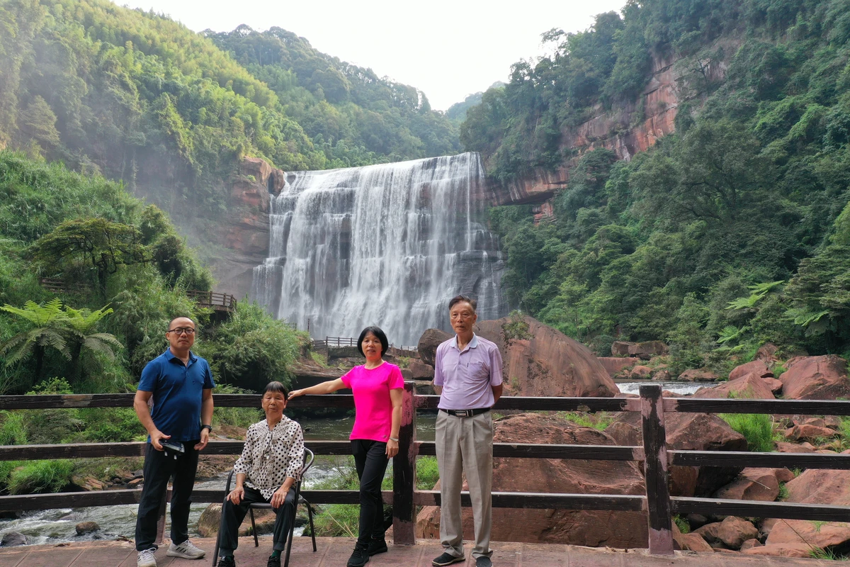
In the morning, we visited Chishui Waterfall, also known as Shizhangdong Waterfall, located in the south of Chishui City, Guizhou Province, on the upper section of the Chishui Valley Tourist Highway. The waterfall hangs on a red Danxia cliff, 8 meters higher than Huangguoshu Waterfall. At the entrance, there is a fork: one side is a walking path, the other is a road for electric carts, and you can choose. The walking path offers views of Danxia landforms and fresh air.
The ticket for Chishui Waterfall is 80 yuan for adults. For the elderly, I recommend taking the vertical elevator at the shuttle bus drop-off point inside the scenic area. It costs 20 yuan one way and 40 yuan round trip. After exiting the elevator, you still need to walk 400 meters. This is easy for the elderly. The waterfall is nice and worth a visit. We got up at 7 AM, drove the car from the inn to the shuttle bus drop-off point. The local staff were very helpful; they guided us to park and then directed us to the entrance. It had just opened, and we were the only four people inside, exceptionally quiet. We enjoyed such a rare treat that we danced under the waterfall, feeling quite triumphant. We played for over half an hour before other tourists gradually arrived.
The magnificent waterfall plunges into the pool, sending up crystal-clear spray, roaring loudly. If you're lucky, you can see a rainbow in the sunlight. Climbing onto the boulders in the pool allows you to experience the waterfall up close.
So, you must choose the right time and place to travel. Staying in this mountain valley had its inconveniences, but spending a night here, we encountered the rare sight of Starlink crossing the starry sky, the long-lost Milky Way, and the joy of having the entire place to ourselves.
After breakfast, we did not return to the Chishui Valley Tourist Highway. Instead, we chose a winding narrow road through numerous large mountains, passing a place called Wuxing Miao Village. Even as a driver with 40 years of experience, I broke out in a cold sweat, fearing a landslide might occur halfway. After 40 km of traveling for 2.5 hours, we finally reached Yuanhou Town, the site of the first crossing of the Chishui River, and breathed a sigh of relief.
Arrived at Tucheng Ancient Town after noon and visited the Four Crossings of the Chishui River Memorial Hall.
The memorial hall in Tucheng Ancient Town is named by former Vice Chairman of the Central Military Commission, Zhang Zhen. It is exhibited in the former site of the Red Army's Third Army Corps Headquarters, a two-story Chinese-Western style building. The exhibition hall has an area of 620 square meters, divided into battle history and auxiliary displays. The battle history display faithfully reproduces the glorious history of the Red Army's four crossings of the Chishui River under Mao Zedong's leadership after the Zunyi Conference in January 1935, until crossing the Jinsha River on May 9, achieving the great victory of strategic transfer. It is divided into five chapters: the Battle of Tucheng, Prelude to the Four Crossings, First Crossing and Zhaxi Reorganization, Second Crossing and Reoccupation of Zunyi, Third Crossing and Luring the Tiger Out of the Mountain, and Fourth Crossing and Achieving Victory by Surprise, highlighting the "mystery" and "miracle" of the four crossings. The auxiliary display includes a themed calligraphy and painting exhibition "Spirit of the Four Crossings, Shining on the Old Revolutionary Area," and restorations of the rooms of Peng Dehuai and Yang Shangkun. The museum houses over 300 pieces of Red Army artifacts.
Lunch in Tucheng was baojiang tofu (fermented bean curd), which was quite tasty.
Then we continued along the Chishui Valley Tourist Highway to Xishui Town, Meijiuhe Town, and south to Maotai Town in Renhuai City. This highway is like a red ribbon on the Chishui River, creating a unique landscape of "scenery within scenery," with beautiful views all along the way. Whether you are driving, cycling, or walking, you can enjoy the roadside scenery. For wine lovers, Maotai Town is definitely worth a visit. First, the overall impression: the buildings and streets in Maotai Town have been renovated with distinctive characteristics, antique and elegant. The whole town highlights the culture of liquor: shops sell liquor, and the air is filled with the aroma of liquor, truly a city of liquor.
Going all the way south, we arrived at Maotai Town, the liquor capital of China, in Renhuai City.
Here, the air is thick with the aroma of strong sauce-flavored liquor. The streets are lined with shops selling liquor, deeply impressing us with Chinese liquor culture. When we were about to go out for dinner, the innkeeper gave me a small bottle of tasting liquor. I tried a little during dinner. Maybe my knowledge of liquor is limited, but I found it average. However, the architecture along the street was quite distinctive, worth visiting for that alone.
Highlights of Maotai Town: 1) National Liquor Culture City. Learn about the development history of Chinese liquor, cultural connotations, flavor types, and the detailed production process and related stories of Maotai liquor. Presented in rich forms, very educational. 2) Yangliuwan. The back door of the National Liquor Culture City leads to Yangliuwan, which preserves the oldest street in Maotai Town and the former sites of Maotai Distillery, including the koji-making rooms and distillery remains of Chengyi and Ronghe. It is a place of pilgrimage for all Maotai lovers. 3) 1915 Plaza's musical fountain and 3D movie at night. Good music, the fountain changes with the melody, very impressive. Next to it is a free movie. The content is very striking. 4) Red Army Four Crossings of the Chishui River Ferry Memorial Hall. Red culture and Maotai liquor culture. It's interesting to hear old Red Army soldiers recall their impressions of Maotai liquor, and it provides another perspective on why Maotai liquor has such a special status in China since the founding of the nation.
Day 8, September 11: Maotai Town to Zunyi Conference Site (88 km) to FAST (China Sky Eye) Scenic Area, 400 km, 5.5 hours, toll 150 yuan. Stayed at Pingtang Guolin Hotel.
After breakfast, we continued sightseeing. Because the air was thick with the smell of liquor, after a brief tour of Yangliuwan, we prepared to leave for our second red attraction—the Zunyi Conference Memorial Hall. The memorial hall's second floor was closed to the public. We only visited the first floor of the conference site and the adjacent exhibition on the Central Communications Bureau (code-breaking and liaison agency). The tour took about 2 hours.
Zunyi Conference Site: In early January 1935, when the Chinese Workers' and Peasants' Red Army arrived in Zunyi during the Long March, the General Headquarters of the Central Revolutionary Military Commission of the Chinese Soviet Republic and its First Bureau (responsible for operations) were stationed in this building. From January 15 to 17, the Zunyi Conference (the Enlarged Meeting of the Politburo of the CPC Central Committee) was held in the main building, in the small living room of the original owner on the upper floor. This meeting established a new central leadership with Mao Zedong as the core. The Zunyi Conference became a life-or-death turning point in the history of the Chinese Communist Party.
After leaving, we went to Leisan Mutton Rice Noodles near the No. 13 Middle School of Zunyi, a local favorite, to have an authentic Guizhou mutton rice noodle. Then we drove to the FAST (Sky Eye) scenic area in southern Guizhou. After arriving, we stayed opposite the Nan Rendong Memorial Hall. Seeing that it was still early, we went over to take a look. The experience hall on the west side of the Nan Rendong Memorial Hall was still open. After some negotiation with the staff, we got a discount to enter and experience it.
Day 9, September 12: FAST Scenic Area to Jingxi Goose Spring Scenic Area, 400 km, 5 hours. Stayed at a local accommodation near Goose Spring in Jingxi.
In the morning, we visited the Chinese Sky Eye (FAST). Visiting the telescope itself does not require a ticket, but you need to buy a shuttle bus ticket for 50 yuan. Before boarding, you must store the following items for free at the visitor center using the QR code on your ticket: all electronic devices such as mobile phones, watches, car keys, chargers, power banks, digital cameras, smart bands, tablets, laptops, walkie-talkies, remote controls; flammable and explosive items such as cigarettes, lighters, matches; and all knives and other prohibited items. It is recommended to bring your ID card and cash, because after getting off the shuttle, you may need to take a direct car up the mountain, and there are over 500 steps to climb. For photos, you pay cash at the observation deck.
From the Astronomy Town Square to the FAST observation deck, you will go through two security checks stricter than at the airport. So be sure to store all prohibited items. After an even stricter security check, you ascend to the observation deck and look into the distance.
① The scenic area requires real-name reservation and ticket purchase, with a daily limit of 2,000 visitors. ② The FAST observation deck shuttle bus is sold separately, and you can purchase it at the security check luggage storage area on the observation deck. ③ If you want to take photos, you can rent a film camera at the camera rental counter at the second security checkpoint, or pay for photos at the observation deck. ④ From the second security checkpoint to the observation deck, you need to climb about 15 minutes. You can buy a round-trip shuttle ticket at the luggage storage area at the first checkpoint (located on the right side of the entrance).
After leaving the observation deck, we had lunch in the town, then headed to Goose Spring, one of the three famous springs in southwestern Guangxi.
Day 10, September 13: Goose Spring Scenic Area to Detian Waterfall to Pingxiang Friendship Pass, 250 km, 3 hours, stayed at Pingxiang Guangyue International Hotel.
Goose Spring, together with Butterfly Spring in Dali, Yunnan, and Ruzi Spring in Guiping, Guangxi, is known as one of the three famous springs in southwestern China.
It is also the source of the Detian Waterfall, the world's second-largest transnational waterfall. We got up early to visit Goose Spring. It takes about an hour and a half to tour the entire scenic area without going up the mountain for photos. The scenic area is quite nice, with many spots for photos and great scenery.
To summarize, I'll list a few points to note: ① The best panoramic photo spot of the 15-arch bridge is on the highway bridge next to it. ② If you want to capture the pastoral scene of a farmer leading an ox across the 15-arch bridge at dusk, you must shoot in the evening at sunset. ③ After entering the scenic area and crossing the wind and rain bridge, the first thing is the Yang Ao Temple; the wall inside records the origin of the name Goose Spring, so you can read it carefully.
At nearly 9 o'clock, it started drizzling. We hurried to the next stop, Detian Waterfall Scenic Area. Detian Waterfall is located in Detian Village, Shuolong Town, Daxin County, Chongzuo City, Guangxi Zhuang Autonomous Region, on the upper reaches of the Guichun River on the China-Vietnam border. The waterfall is majestic and spectacular. It is connected to the adjacent Vietnam's Ban Gioc Waterfall and is the largest transnational waterfall in Asia and the fourth largest in the world. Its average annual water flow is about three times that of Huangguoshu Waterfall in Guizhou. It is a National AAAAA-level tourist attraction.
It is also the filming location for "The Legend of the Condor Heroes"? Actually wait: "《酒是故乡醇》" and "《花千骨》" are TV dramas. So: "It is also the exterior filming location for 'Taste of Home' (Jiu Shi Gu Xiang Chun) and 'The Journey of Flower' (Hua Qian Gu), magical and wonderful." Below the waterfall is the clear Guichun River, a tributary of the Zuojiang River (part of the Pearl River system) and the border river between China and Vietnam. Here, it's natural to take a bamboo raft to get closer to Detian Waterfall. The tour route in Detian Waterfall is a loop. First, you go down to the riverbank, then take a raft from downstream towards the waterfall to admire it up close.
The rain grew heavier along the way, but it stopped when we arrived at Detian. We didn't bother with lunch and quickly bought tickets. Because we didn't reserve the discounted tickets for Guangdong residents before 8 o'clock, we bought another type of all-inclusive discounted ticket for 140 yuan per person, which spared us the 80 yuan main ticket. We took a sightseeing bus into the area. A guide on the bus introduced the scenery and culture along the way. After getting off, we boarded a bamboo raft at the second boarding point and headed towards the cross-border waterfall.
Then we got ashore and walked slowly along the trail towards the China-Vietnam border commercial street.
We had lunch at the Baguette Museum. Because the elderly didn't dare to ride the high-altitude slide, my wife and I took the magic carpet to the upper observation deck, which is the best viewpoint for the entire Detian Waterfall.
Riding the magic carpet to the highest observation deck, we could see the full view of Detian Waterfall and the Vietnamese village scenery across the river.
At 4 PM, we finished the tour and left the scenic area. After eating some snacks in the parking lot, we drove to the next attraction, which was also our accommodation for the night: Pingxiang Friendship Pass. Initially on G219, we later turned onto county roads 542, 543, and then 564. The mountain scenery on both sides was remarkably beautiful, like a poetic painting, very picturesque, like Chinese oil paintings. Unfortunately, after flying the drone in the morning, I forgot to turn off the remote control, and it only had 6% battery left. I dared not launch the drone. The sky was grayish and threatening rain, so I feared losing control if I flew it. So I had to give up. We continued a bit, and indeed it rained. Not wanting to continue in the rain on the county road, we exited the county road at Zhubu expressway entrance at 5:28 PM and got on the expressway. At 6:20 PM, we exited at Pingxiang. It rained all the way to Pingxiang city center. In the evening, we had a Southeast Asian specialty meal in Pingxiang. After all the Chongqing and Guizhou cuisine on the road, the elderly were finally satisfied.
Day 11, September 14: Pingxiang Friendship Pass to Dongxing City, 280 km, 7 hours, stayed at Donghe Hotel in Dongxing.
In the morning, the weather looked worse. We decided to brave the rain and set off for Friendship Pass, visiting one of China's ten famous passes, the Sino-Vietnamese border Friendship Pass. To the left of the pass building is the Zuobi Mountain city wall, and to the right is the Youfu Mountain city wall, like giant pythons linking the two mountain feet, majestic. Friendship Pass is located at the southwestern tip of Pingxiang City, Guangxi. The terminal of National Highway 322 passes through the arched gate of Friendship Pass and connects with Vietnamese roads. It is an important land passage to Vietnam and a national first-class port, 18 km from Pingxiang city. My original plan was to drive along G219 from Friendship Pass via Aidian Town and Tongzhong Town to Dongxing Port, experiencing the steepness of the Shiwandashan Mountains and the beautiful border scenery. But at Friendship Pass, it kept raining.
During our visit to Friendship Pass, the rain intensified. My wife even slipped on the battery platform. At 11 o'clock, we discussed and decided the weather was no longer suitable for sightseeing. So we left Friendship Pass and started our return journey. On the Nanyou Expressway, the weather cleared up. We decided to try our luck and head to Dongxing Port. As luck would have it, there was no rain in Dongxing at all. We arrived at Dongxing just after 4 PM, still early. We strolled around the port area. Many Vietnamese were selling goods by the port, and things were very cheap. My wife and others were busy buying from the Vietnamese vendors.
Dongxing Gate Scenic Area is a symbol of the national gate and a national first-class port where China and Vietnam rely on each other's cities. Most tourists visiting Dongxing stop at the port, saying "Not going to the port means not truly visiting Dongxing." The scenic area mainly offers tours and shopping at the national gate, a future shopping paradise and sightseeing spot. The planned construction includes French-style arcade streets, tourist shopping streets, shopping malls, an international tourism distribution center, and a Sino-Vietnamese Friendship Park. The scenic area consists of three parts: the Sino-Vietnamese Friendship Park, the Port Pedestrian Street, and the Chen Jitang Memorial Hall. These three parts are connected by the Beilun River, which forms the border with Vietnam. The port atmosphere is very prominent, and on the Vietnam-style street, you can experience exotic customs and Vietnamese cuisine.
Later, we inquired at a shop about using ID cards for a one-day tour of Mong Cai, only to learn that such tours with ID cards had been suspended a month ago; passports were now required. This disappointed the elderly greatly. After all the twists and turns to get to Dongxing for an overseas trip, our plan failed.
Day 12, September 16: Dongxing City to home.
Because we learned that heavy rain was falling in the Guangdong area, we had to cancel our plan to stop in Zhaoqing and just head home directly.
After breakfast, we headed straight to the G219 National Highway Memorial Square. On the way, we passed a police checkpoint. A car from Nanning was pulled over; the police officer asked the driver to blow into a breathalyzer. The reading exceeded the alcohol limit, so the driver was detained. So, fellows, don't think it's safe to drive the next day after drinking the night before. The consequences can be harsh. Be cautious: don't drink and drive, never drink and drive, even if it was the previous day.
After taking photos there, we asked a police officer on duty at the square. He said the zero-kilometer starting point is in Zhushan Lane at the mouth of the Beilun River, which is the starting point of the border road and also the location of the Great Qing State Qinzhou No. 1 Boundary Marker. We followed the navigation to the starting point of the border road, which is now incorporated into G219, considered its starting point.
In August 2000, the Guangxi Zhuang Autonomous Region Party Committee and Government decided to launch a border construction campaign in eight border counties and cities. The campaign lasted three years with a total investment of 2.1 billion yuan. The landmark project was the construction of the border road. The road was designed as a third-class highway. Construction began in October 2000, with a total investment of 920 million yuan, and was fully opened on September 30, 2002. The border road starts at Zhushan Village, Dongxing Town, Dongxing City, passes through 8 counties and cities including Dongxing, Fangcheng, Ningming, Pingxiang, Longzhou, Daxin, Jingxi, and Napo, and 31 towns, ending at Nonghe Village, Napo County, with a total length of 725 km.
The zero starting point marker of the Guangxi border road—Zero Point Memorial Altar—is located at the eastern end of the Beilun River estuary embankment, on the Wuqi Dike.
Dongxing's landmark—the Mountain-Sea Connection Landmark Plaza—has a 35-meter-tall sculpture made of red and blue interlocking abstract "Xing" characters. Red and blue symbolize the connection of mountain and sea, also representing the "mountain and water connection" between China and Vietnam.
Along the Beilun River banks, there are eight boundary markers of the Great Qing State Qinzhou boundary, numbered 1 to 8. In Zhushan Village, the Great Qing State Qinzhou No. 1 boundary marker is preserved. It was erected in February of the 16th year of the Guangxu reign (April 1890). The inscription was written by Li Shoutong, then the General Manager of Boundaries Affairs and Prefect of Qinzhou Prefecture. The No. 1 boundary marker, as a historical witness of the Chinese people's defense of national dignity and territorial integrity for over a century, has now become a tourist attraction drawing domestic and foreign visitors.
We had lunch at a farmhouse restaurant near the boundary marker in Zhushan Ancient Village. Then we prepared to return to our warm home. Heavy rain fell throughout the journey. We had planned to stop in Zhaoqing for a night's rest to ease the fatigue of travel, but it was raining everywhere. Finally, we decided to head straight to Shenzhen, arriving home in the early hours.