2020 Sichuan-Tibet Journey
Tibet has always been a place many people yearn for, and there's even a saying that 'you must visit Tibet at least once in your life.' A few months ago, we started planning a trip to Tibet. We began by asking experienced friends and relatives for some tips on entering Tibet, and we followed public accounts like 'Xixingbang Tourism' and 'Tibet Traffic Police' to plan our itinerary and check real-time road conditions. In mid-July, after learning that the Sichuan-Tibet highway had been repaired and was open to traffic, we packed spare food, medicine, emergency supplies, clothes, and set off on the 16th.
Around 10 a.m., we departed from Shunde. Traffic was light and the roads were clear, so we drove non-stop until we reached Sanjiang County in Guangxi before stopping for the night. It was still early, so we strolled around the town. The county's central square was built in a Dong ethnic style, though it looked simpler compared to the Dong villages in the countryside.
Total day's drive: 610 km; fuel: 350 yuan; tolls: 355 yuan.
We set out from Sanjiang County early in the morning and drove north across Guizhou Province. This stretch of highway had many tunnels, so it took longer than usual. By a little after 3 p.m., we had entered Sichuan. We continued driving and stopped in Yibin City to rest.
Total day's drive: 840 km; fuel: 580 yuan; tolls: 550 yuan.
Today, as planned, we explored the area nearby. In the morning, we visited the Wuliangye Distillery in Yibin. As everyone knows, Chinese baijiu often has a long historical story behind it. Wuliangye is a famous Chinese liquor, and detailed information about its origins and cultural history can be easily found online. Our first impression upon arriving at the distillery was its vast size—so large that even the nearby airport is named 'Wuliangye Airport,' which shows its influence! There are many roads inside the facility, allowing visitors to drive slowly and enjoy the sights. The roads were bustling with trucks hauling raw materials and finished liquor. The air was filled with the pleasant aroma of grains and alcohol. The site has many attractions: the Wuliangye Liquor Culture Museum, the Endeavour Tower, Pengcheng Square, screen walls, and more. Visitors can also get close to the earthen kilns and fermentation workshops. We chose a few roads to cruise along, took photos at some spots, then went to the sales office to buy some souvenir liquor before leaving for the next attraction.
At noon, we arrived at the Leshan Giant Buddha cruise dock and took a boat to view the giant Buddha. I had been here over a year ago, but at that time the site was under maintenance and I couldn't see the full statue, which was a bit disappointing. Today, I finally got my wish.
The boat moved slowly along the Min River. From a distance, we could already see the Buddha, and all the passengers spontaneously stepped onto the deck to watch. When the boat reached the front of the Buddha, the captain stopped so we could admire it. The Buddha seemed to stand as tall as the mountain itself, towering over the river and the tourists, with the turbulent Min River rushing by—a truly awe-inspiring sight. In that moment, I felt like belting out the song 'A Laugh Over the Sea'!
After viewing the Buddha, we packed up and drove west, reaching the first county town on the Sichuan-Tibet route—Ya'an—and checked into a hotel.
Total day's drive: 330 km; tolls: 130 yuan.
Starting from Ya'an, we drove on the expressway for just over an hour before reaching Luding County. Exiting the expressway, we turned onto the national highway and ran parallel to the Dadu River. Looking out the window, we saw the river rushing fiercely, its swift current pounding against the cliffs and boulders along the bank, roaring incessantly. Following the road, we arrived in Luding county seat and visited a revolutionary tourism site—the Luding Bridge. In 1935, during the Long March, the Red Army fought the famous battle to 'seize Luding Bridge' against Nationalist defenders. The Dadu River, about a hundred meters wide, surged downstream with violent, clashing currents—extremely treacherous. Nine thick iron chains, each as thick as a rice bowl, linked the two banks—this was the Luding Bridge. The chains hung about twenty to thirty meters above the rushing water. Wooden planks were laid over the chains to make it easier for tourists to walk. Back then, when Red Army soldiers stormed this strategic point, the advance assault team crawled along the bare chains while engaging the enemy in combat. It really shows the immense difficulty and danger! The victory of the Chinese Revolution didn't come easily, and we should treasure it!
We walked across the bridge and back, read some historical accounts, then left Luding County and continued onward. Before long, we arrived at Kangding. The westbound expressway ended here, and we turned onto National Highway 318, the Sichuan-Tibet section. The road wound upward, climbing Zheduo Mountain at an altitude of around 4,200 meters. This mountain marks the boundary between Sichuan's Han and Tibetan regions. As first-timers to high altitude, we began to feel a bit weak and short of breath. But because I'd climbed Jade Dragon Snow Mountain before, I didn't take it too seriously (though later experience proved me wrong). After enjoying the view from the summit, we started descending towards Xinduqiao. The scenery along the way was stunning—brooks, meadows, herds of cattle and sheep, Tibetan-style houses—all complementing each other with distinct Kangding charm. Every snap was picture-postcard perfect.
Since high-altitude sickness has a delayed onset, the earlier neglect on Zheduo Mountain caught up with us when we reached Xinduqiao, so we found a guesthouse to stay. In the hours that followed, I felt quite miserable. Fortunately, some members of our group didn't have severe altitude sickness; one of them busied herself looking after us—thanks so much to her. By evening, we realized we needed medication, so depending on our symptoms, we took medicine or used oxygen. Soon, everyone's condition improved, and it seemed we were free of altitude sickness, allowing us all to rest comfortably. The guesthouse owner was very kind; seeing our state, he reassured us that all first-time visitors to high altitude go through this, not to be afraid, and that we'd be fine before long. He also brought us extra oxygen canisters.
Total day's drive: 370 km; fuel: 440 yuan; tolls: 130 yuan.
We woke up feeling much better, perhaps already acclimatized a little, so we began to appreciate the surroundings more. We took a walk around the guesthouse and chatted with the owner. The place was surrounded by mountains on all sides; nearby there was a monastery. On a distant grassy mountaintop, a string of Tibetan script was embedded—it looked like plants of different colors had been planted and trimmed to create the words. This is a Tibetan feature; we would see similar displays on many mountaintops in the following days. The guesthouse owner was also a monk, a director at the nearby monastery. His house had been converted into a guesthouse. During festivals, villagers and monks gathered there for celebrations, which explained the huge kitchen and abundance of utensils.
After breakfast, we left Xinduqiao and continued onward. All along, high mountains, rivers, flowers, and yaks accompanied us. The road zigzagged along National Highway 318, and we crossed the 4,700-meter Kazila Mountain, eventually reaching the 'high city of the world,' Litang County (around 4,000 meters). After a simple lunch, we drove at over four thousand meters, with grassy meadows and thin patches of snow alongside the road. Soon we came to a viewpoint, where between blue sky and mountain ranges appeared a pair of lakes—almost identical in shape and size, like silver plates or green jade—the Sister Lakes. Farther in the distance, snow-capped peaks stood like jade screens behind the sisters. After lingering for a while, we left the viewpoint and descended all the way to the westernmost county town on the southern Sichuan-Tibet route within Sichuan—Batang County.
Total day's drive: 350 km; fuel: 380 yuan; oxygen and protective items: 200 yuan.
After checking information the previous night, we decided to cover the planned three-day journey from Batang to Nyingchi in two days, which would also help us avoid sleeping at very high altitudes. So we set off very early. Not far out, we encountered roadwork that halted traffic, and we had to wait about 40 minutes before moving on. Another half hour of driving brought us to the Jinsha River Bridge. This bridge connects Sichuan and Tibet; crossing it, we entered the Tibet Autonomous Region! The road was perilous all the way, often squeezing through narrow gaps between steep peaks and rivers, or winding and climbing along tortuous mountain paths. After circling up one mountain ridge after another, we could then enjoy driving on high-altitude meadows for a while. The rivers accompanying us flowed at a high speed, crashing powerfully against boulders in the water and the banks—a spectacular sight. But the river currents were unpredictable, sometimes following our direction, sometimes flowing against it. Later, checking a map, I realized the rivers we saw today were the Jinsha, Lancang, and Nu Rivers, each flowing in different directions. During the drive, we traversed mountains like Jueba and Dongda, all around four to five thousand meters. Above four thousand meters, the air was thin; even getting out to look at the scenery required slow, careful steps, and after getting back in the car, we needed a moment to catch our breath before continuing. The car engine also seemed to struggle, but luckily it had a 2.0T engine; stepping on the gas engaged the turbo for ample power, and with its comfortable, safe suspension, it carried us steadily over the mountains and through the valleys. Amid this rugged beauty, we passed Markam, Bangda, and other areas, drove the famous Seventy-two Turns, and reached Baxoi County in the evening to rest.
Total day's drive: 470 km; fuel: 375 yuan; oxygen and protective items: 150 yuan.
Last night as soon as we checked into the hotel, we received news that the road between Tongmai and Nyingchi on National Highway 318 had suffered a landslide and was closed again—we nearly broke down! This morning in the restaurant, we met many fellow travelers discussing the situation. After comparing the expected closure time with the extra time needed to take alternative routes, we decided to stick to our plan and go ahead. Among several major mobile navigation apps, Baidu Maps actually showed the road as clear, which boosted our confidence (though later it proved that some map updates are unreliable). So we pressed on with a shred of hope. But when we reached Midui Glacier, all sources confirmed the definite 'road ahead blocked' message, so we entered the Midui Glacier scenic area to explore. Taking a sightseeing bus from the visitor center to the core area, we hiked about 2 kilometers to the glacier viewing platform, where we could see the entire glacier and its features: the cirque, ice tongue, streams from melting ice, a lake formed by meltwater, and spruce forests on the mountains supporting the glacier. Hiking at nearly four thousand meters, with constant stairs to climb, left us all panting and tired, but none felt seriously unwell, which meant we had basically acclimatized.
After the tour, we left the scenic area and continued west. The roadside scenery changed again. The road became gentle, lined with tall pine trees. In the distance, under high mountains, barley fields, flower fields, meadows, sheep, and cottages created a scene reminiscent of European farmland. Soon we arrived at Bomi County, where we stayed to wait for the road to reopen.
Total day's drive: 220 km; entrance fees: 260 yuan.
With the road ahead blocked and detours too far, we had no choice but to wait in Bomi. In the morning, strolling around town, we met a few tourists from Foshan who were also waiting for the road to open. We exchanged contact info so we could keep each other updated. Searching for nearby attractions, we decided to visit Guxiang Lake.
Guxiang Lake wasn't far from the county seat, and we got there quickly. Here, a tributary of the Yarlung Tsangpo River widens and slows, forming a wetland park-like scene with the surrounding mountains and pine forests—a tranquil, pleasant contrast to the rushing rivers we'd seen. The area had two leisure resorts, seemingly part of a recent tourism poverty-alleviation project, but perhaps due to the pandemic or management issues, there were very few visitors in this serene getaway! On top of that, the road closure had thrown our schedule off, so we weren't in the cheeriest mood and didn't pay much attention to the beautiful scenery.
In the afternoon, we returned to the hotel, borrowed some kitchenware, and went to the market to buy fresh matsutake mushrooms and meat. Once the delicious food was served, our spirits naturally lifted!
Total day's drive: 50 km.
In the morning, we wandered the streets again, bought some local specialties, and then waited in the hotel for traffic updates. Around 2 p.m., we heard that armed police troops had built a diversion road next to the landslide site, the road was reopened, and one-way traffic was being allowed. We cheered, immediately packed up, and hit the road. Since many vehicles had been stranded, traffic jams were inevitable. Passing two recent landslide sites and seeing the shocking damage to the road was truly frightening! Around the emergency repair section, many armed police, traffic police, and regular officers were directing vehicles to pass through the dangerous spots quickly. On one side of the landslide was a cliff, on the other a raging river; looking down twenty to thirty meters, it was terrifying. Repair crews and heavy machinery were working under dangerous conditions. As we crested a small hill on the temporary bypass, a large rock blocked our way. Several armed police gestured for us to stop, then together moved the rock by hand so we could pass. I rolled down the window and thanked them repeatedly, deeply impressed!
After passing the checkpoint, the road was clear, and we soon reached Lulang Town. Here we saw the distinctly European-flavored Lulang Meadow. Driving on, we passed through the fairyland-like Lulang Forest. We took our time admiring the views, then wound down the mountain road until we reached Nyingchi City to rest.
Total day's drive: 220 km; fuel: 185 yuan.
Early in the morning, the sky was overcast with light rain. We guessed visibility at the Yarlung Tsangpo Grand Canyon wouldn't be good, so we reluctantly dropped that scenic spot from our plan. We set off from Nyingchi and drove straight to Lhasa via the Nyingchi-Lhasa Expressway. Half an hour later, the sky cleared, and everything suddenly became vibrant with color. Under blue sky and white clouds, we saw tree-covered slopes one moment, then suddenly brown boulders, or red-soil mountains set against vast golden canola fields, then endless meadows... It was a constant feast of breathtaking scenery!
In the afternoon, we left the expressway and, after passing inspection and quarantine stations, entered Lhasa city. It was still early, so we checked the map, found that Yamdrok Lake wasn't far, and headed directly there. About thirty-odd kilometers from the lake, there was a visitor center. We bought tickets, then drove along National Highway 349, crossing the 5,000-meter-high Gambala Pass, and from a distance we could already see Yamdrok Lake. One of Tibet's three great sacred lakes, it looked like a turquoise gem set into the mountain ridges at 4,400 meters. Continuing to the lakeshore, we saw the water was stunningly blue, with snow mountains in the distance, meadows nearby, and rapeseed flowers along the bank, forming a colorfully harmonious yet mysterious picture. We strolled near the viewing platform, but walking around at almost 5,000 meters wasn't easy—after a few steps, we were panting heavily and turning pale! We had to slow down, resting every few steps, yet our eyes greedily soaked in the scene. Then we retraced our route and headed into downtown Lhasa to rest.
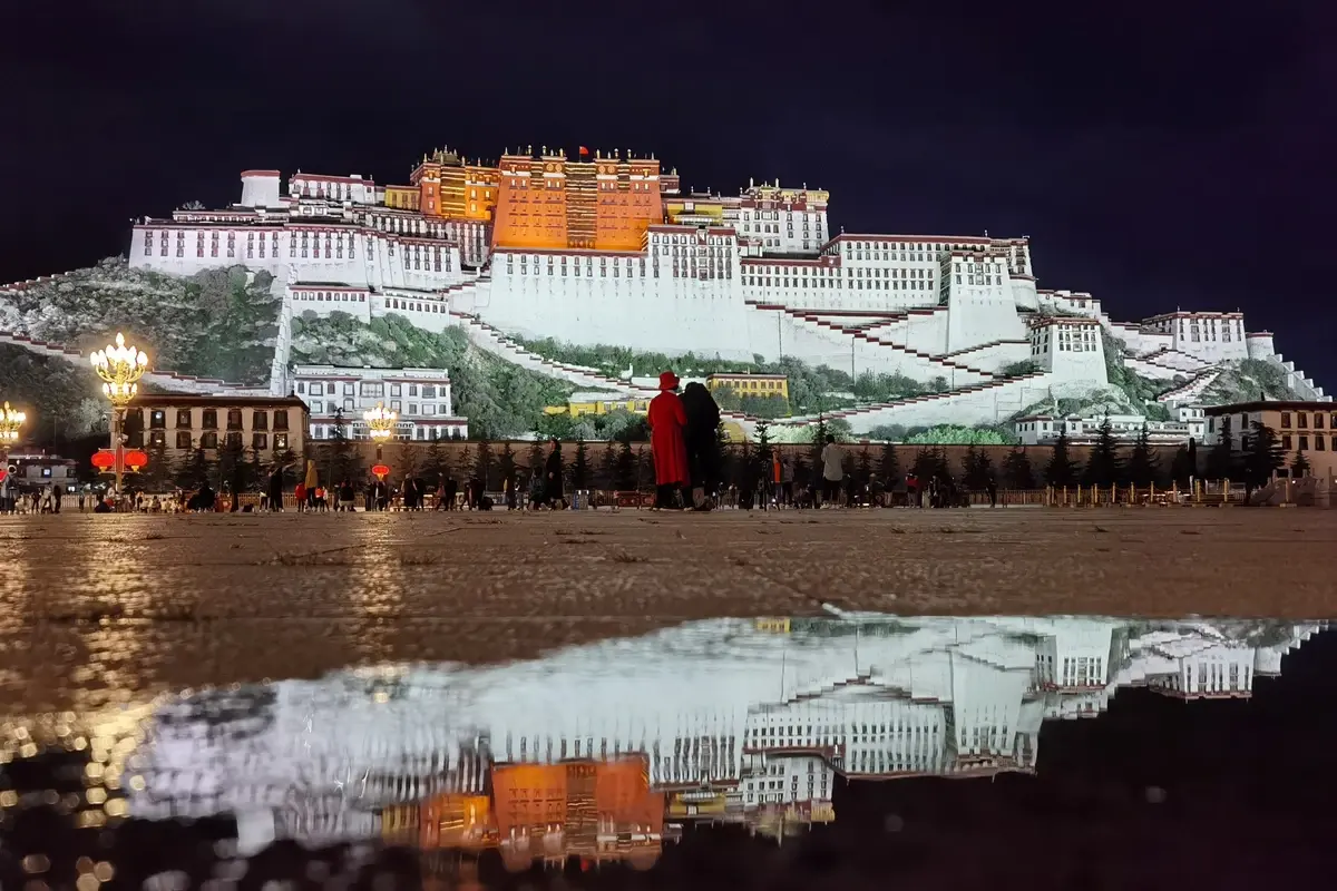
After dinner, we walked several kilometers in the city to Potala Palace Square to admire the palace's night view. Bathed in lights, the Potala Palace looked like a heavenly temple fallen from the sky, floating in the air, resplendent with gold and radiating myriad colorful beams. The square was full of visitors, all here to take in the sight and snap photos. It was easy to strike up conversations with fellow travelers, sharing experiences and travel plans.
Total day's drive: 600 km; fuel: 365 yuan.
We had booked tickets to visit the Potala Palace a day in advance, so we could enter early in the morning. The history of the palace's construction and reconstruction is well known. But when you see it up close and step inside, you still marvel at its grandeur and uniqueness. Built on a mountain, it's a massive complex over 400 meters wide, more than 300 meters deep, and nine stories high. The exterior is complex and varied in form, exuding majesty. The red, white, and yellow colors are vivid and harmonious, pleasing to the eye. Walking up the zigzagging ramps connecting to the main hall, each turn reveals a different style. In the wall structures, dried grass was sandwiched between the bricks and stones—later reading told me this is baima grass, soaked in medicinal liquid to lighten the walls and improve ventilation. From the walkways, you could look out and see the whole of Lhasa spread below, very refreshing. On a distant mountain meadow, four huge characters spelled 'Long Live the Motherland.'
Climbing up to the palace entrance, we stepped inside. The halls and rooms were countless, packed tightly together; thangkas and murals were everywhere; gilded statues of Buddhas, arhats, and bodhisattvas abounded. On the rooftops, golden ornaments gleamed under the sun, reflecting dazzling light. In the highest hall, a gold spirit pagoda presented by Emperor Qianlong to the palace was enshrined in the center; the guide said it weighed over three tons. After admiring it for a while, we followed the flow of tourists downward, exited from the back of the mountain, and walked slowly around the palace. We saw many monks making devout pilgrimages around the Potala Palace, prostrating themselves every few steps and chanting sutras. Many tourists offered them small change.
Leaving the Potala Palace, we returned to the square to further admire this masterpiece from a distance. Then we strolled through the city and happened upon a small restaurant with a sign saying 'Cantonese Cuisine.' We immediately went in, heard the familiar Cantonese dialect, and tasted rich flavors of home!
In the afternoon, we visited Jokhang Temple. This grand Tibetan Buddhist monastery was built under the patronage of Songtsen Gampo, a powerful Tibetan ruler during the Tang Dynasty. Locals consider it the heart of all Tibetan Buddhist temples and the world's Buddhist center, making it extremely sacred to them. The temple is magnificent; its main hall faces west, with Shakyamuni Buddha enshrined in the center. Surrounding the main hall are smaller shrines to various Buddhas and bodhisattvas. Everywhere inside, butter lamps flickered, emitting a unique fragrance different from the choking incense smoke common in coastal temples. We paid our respects to Buddha in the main hall, then casually visited a few smaller shrines. After that, we went up to the second-floor rooftop to admire the main temple structure, then left. During today's tour, we hired a guide to explain things, which helped us understand Tibetan Buddhism, valuable knowledge about Jokhang Temple and the Potala Palace, and some folklore—well worth it.
Just outside Jokhang Temple is Barkhor Street, lined with shops selling Tibetan crafts and local products. We browsed for a while before returning to the hotel to rest.
Total day's activities in town; tickets, etc.: 1,000 yuan.
Morning came. We packed up, climbed a nearby pedestrian bridge to gaze at the Potala Palace in the morning light, then reluctantly left Lhasa. We drove north on National Highway 109 for about four hours, reaching Damxung County, where we turned off toward Namtso Lake. After buying tickets at the visitor center and having a simple lunch, we headed into the scenic area. Along the way, we stopped at a viewpoint. While enjoying the scenery, a little girl bounded out of a herder's thatched hut nearby, her cheeks rosy with a highland flush, wearing a happy smile, her eyes twinkling as if they could talk—absolutely adorable. We pressed snacks into her hands and clicked the shutter. This little interlude added a touch of joy and a fond memory to our journey!
Continuing onward, we crossed Nagenla Pass at about 5,200 meters and caught sight of Namtso Lake. It's also one of Tibet's three great sacred lakes, vast in area—said to be roughly the size of Shenzhen city. Walking about a kilometer from the parking lot brought us to the lake shore. The water was incredibly clear, and under the sunshine it was exceptionally translucent, set against distant snow mountains and blue sky with white clouds—breathtakingly beautiful. Some herders brought white yaks to the lake for tourists to ride and photograph, singing Tibetan songs at the top of their voices, adding vivid life to the scene.
After touring Namtso, it was still early, so we continued our journey. Since conditions weren't ripe for us to go to Mount Everest or the Ngari region, finishing Namtso meant the main sightseeing of our Tibet trip was over. As we left, we couldn't help feeling a bit nostalgic.
We planned to return to Sichuan via the northern Sichuan-Tibet route, so we left Damxung County and continued north on National Highway 109. This stretch stayed mostly above 4,000 meters. Occasionally, we'd spot a train speeding along the Qinghai-Tibet Railway, like a scene from an old movie, drawing excited gasps from everyone. After more than three hours, we reached Nagqu City at 4,650 meters and checked into a hotel. It was our first time sleeping at such a high altitude, and the room's oxygen supply wasn't great, so I had a bit of a headache and breathing trouble at night.
Total day's drive: 350 km; fuel: 470 yuan.
A restless night with altitude sickness—I couldn't wait for dawn. Nagqu City is where the Qinghai-Tibet Highway (G109) meets the northern Sichuan-Tibet route (G317). We chose to go east on G317. The entire way was high-altitude terrain of 4,000 to 5,000 meters, with scenery dominated by alpine meadows and Tibetan buildings. The section between Nagqu and Sog County was under repair in many places, full of potholes, which took a lot of time and energy. Passing through Baqen and Dêngqên counties, by the time we reached Riwoqê County it was almost dark, so we stopped to rest there.
Total day's drive: 530 km; fuel: 440 yuan.
Starting from Riwoqê, we continued east. We crossed many more mountains of 4,000 to 5,000 meters, winding through countless hairpin turns. Around 4 p.m., we crossed the Jinsha River Bridge again, returning to Sichuan. After another three-plus hours of driving, we entered Garzê City in the evening.
Total day's drive: 600 km.
Leaving Garzê City, we headed towards Seda. Around noon, we arrived at the Seda Larung Gar Buddhist Academy. At the gate, we learned it wasn't open—neither cars nor pedestrians were allowed in. Everyone felt a bit dejected. Walking around nearby, we met a local who said he could guide us on foot up a nearby hill to see the academy from a distance, so we set off with this 'guide.' The path wasn't far, but climbing a small hill at over 4,000 meters was still very strenuous. Fortunately, we'd been at high altitude for several days and had adapted somewhat, so except for one member who needed the guide's help, everyone managed. After about 40 minutes, we could finally see the academy grounds from afar. A bit further, we saw other tourists walking ahead, so we followed them onto the campus roads.
Along the way, we saw red wooden huts where teachers and students live. Both men and women, young and old, were coming and going, all wearing monk robes. We followed a campus road to a bus station, which was the center of the campus, and next to it a staircase path led to the hilltop. After climbing a stretch, we could see the full view of the academy. Under the blue sky, row upon row of lush green mountains were dotted with countless red wooden houses, large and small, densely packed from the foot to mid-mountain—an absolutely stunning sight, a visual feast. Looking down at the bus station square, people in crimson robes moved about. This scene was both novel and mysterious, creating a sense of distance yet unmistakably placing us right in it—a strange feeling. Since the academy wasn't fully open, we didn't ask anyone for more details or venture further up to the sky burial site. We lingered a while, then left Seda Buddhist Academy and continued our journey home, staying overnight in Barkam County.
Total day's drive: 350 km; fuel: 340 yuan; other expenses: 200 yuan.
Days 16 and 17
From Barkam back to Shunde, Guangdong, we passed through Sichuan, Guizhou, and Guangxi provinces without stopping much, following a drive-straight-home pace. We arrived home on the evening of August 1, ending a hard, thrilling, yet very joyful journey.
Two days' total drive: 2,050 km; fuel: 1,000 yuan; tolls: 1,100 yuan.
The above is a diary of our Sichuan-Tibet trip. Looking back, when traveling on the Sichuan-Tibet highway, the scenery is truly on the road; every step, every angle is a beautiful picture. Official scenic spots let visitors get closer to the highlights, so they're worth enjoying too. The driving and living experiences were also valuable parts of the journey. The conditions on National Highways 317/318 are quite treacherous, with many curves and narrow sections, often with sharp bends every few dozen or hundred meters, or squeezing between cliffs, riverbanks, and towering mountainsides. Overtaking, for instance, often required waiting for multiple opportunities, especially behind large trucks. Fortunately, many truck drivers were very considerate—when they spotted a gap between curves, they'd stick their hand out the window to signal you to accelerate and overtake on the curve.
Yet on this harsh, oxygen-deprived high-altitude road, we frequently encountered motorcycle warriors, cyclists, backpackers with full gear, and even several prostrating pilgrims making their way by bowing flat to the ground every few steps. Their perseverance was truly moving! They formed a stark contrast with the wild Tibetan landscape and road conditions, becoming a special scenic thread and a complement to nature.
From near Chengdu to Lhasa, it normally takes about five days. If there's an unexpected road washout or repair, you have to wait in place. That's why planning your overnight stops is important, because on this route, only county towns offer relatively decent eating and lodging conditions, and you also need to consider staying at lower-altitude counties to ensure quality rest. Often, it takes two to three hours to drive between county seats.
Even though we'd been to other high-altitude places before, we still experienced varying degrees of altitude sickness on this trip, which shows that altitude sickness depends on individual health, mental preparation, weather, and other factors. From this experience, I've learned: first-timers to high altitude should neither be afraid nor take it lightly. Before reaching an area of 3,500 meters, it's best not to overeat, to avoid putting extra strain on the digestive system. Above 3,500 meters, avoid strenuous movements (like jumping or running) and don't let cold wind blow on you. If you feel a little unwell, take small, spaced-out amounts of oxygen to slow organ hypoxia. When symptoms like headache or vomiting appear, take the appropriate medicine promptly—it can relieve the suffering. Once your condition stabilizes a bit, gradually lengthen the intervals between oxygen use and eventually stop.
After arriving at high altitude, the reaction is usually strongest within one to two hours while at rest, but with proper management and adjustment, it starts to ease after six to eight hours. Try not to rely on continuous oxygen, or adaptation will take a long time.
The Sichuan-Tibet trip was a journey of scenery and living experience, a journey of driving challenges and endless fun. Though it ended some time ago, the joys and hardships still linger in our minds! Looking forward to the next, even more exciting journey!
All text and images above are original; please do not plagiarize, or you may face legal liability!!!
The Travelers
Autumn 2020


