Fairy Mountain Town - A Wonderland-like Place (5-Day Tour of Wulong, Chongqing)
D1 (Sep 8, Friday): Leave Chengdu in the evening and stay in Chongqing
Take a train from Chengdu East Railway Station to Chongqing.
There are frequent trains from Chengdu East to Chongqing, including those to Chongqing West and Chongqing North (intercity).
Tip: Although there are many high-speed trains and bullet trains from Chengdu East to Chongqing, you may still not be able to buy a ticket on the day of travel. It is recommended to check train ticket information and purchase tickets in advance.
We took the following high-speed train from Chengdu to Chongqing:
G8731 Chengdu East (depart) 17:25 – Chongqing North (arrive) 19:14 (1h49m) (Second class ¥161)
It takes nearly 2 hours from Chengdu East to Chongqing North by high-speed train.
Chongqing North Station is about 18 kilometers from downtown Chongqing.
We chose a hotel near the station, located in Yubei District.
After getting off the train, we took a taxi to the hotel.
D2 (Sep 9, Saturday): Leave Chongqing at noon to Wulong (Wulong District) Fairy Mountain Town for accommodation
After being tired from the 9-day trip to Western Sichuan, we slept in.
After getting up, we tidied up and packed the items for the 3-day trip to Wulong.
Other luggage was left at the hotel front desk.
The Three Natural Bridges, Dragon Water Gorge Ground Crack, and Fairy Mountain in Wulong District are popular attractions in Chongqing.
These scenic spots are located in Fairy Mountain Town, Wulong County.
The most convenient way to visit these attractions is by self-driving.
After lunch, we went to Chongqing North Station (South Square) to pick up the rental car.
Inspected: engine, tires, engine oil, coolant, brake fluid, windshield washer fluid; test drove.
After checking the car, we drove to "Cuiyun Road" in Fairy Mountain Town, Wulong District at 13:30.
Route (navigate to [Fairy Mountain Town Cuiyun Road]):
From Chongqing North Station (eastbound) via Inner Ring Expressway and Baomao Expressway to Cuiyun Road in Fairy Mountain Town, Wulong – 204 km, 3h30min, 5 traffic lights (toll ¥90)
(169 km of expressway, passing 5 service areas).
When 46 km from Wulong Town, we entered a tunnel group stretching 12.9 km. The tunnels have interesting names: "White Horse", "Sheep's Horn" (4.6 km), "Big Bay" (3.2 km).
We arrived at Cuiyun Road in Fairy Mountain Town at 5:00 PM.
Wulong has an average elevation of 1900 m, with temperatures 3-4°C lower than Chongqing.
There are thousands of hotels and guesthouses in Fairy Mountain Town to choose from.
We found a guesthouse with an elevator.
We had an early dinner and went to bed early.
Cuiyun Road is not on the main road and has little traffic, making it very quiet further up.
(Today's driving: 204 km, 3h30min)
D3 (Sep 10, Sunday): Full-day visit to Wulong Three Natural Bridges and Dragon Water Gorge Ground Crack
Three Natural Bridges, Dragon Water Gorge Ground Crack, Fairy Mountain Forest Park
Prepare trekking poles, raincoat, hiking shoes, mosquito repellent, food and water.
At 8:20 AM, we drove to Fairy Mountain Visitor Center.
Parking: approx. ¥5/hour; 400 spaces.
Address: West of Fairy Mountain Visitor Center, Wulong County, Chongqing (east of Ginkgo Avenue).
Photo: Fairy Mountain Visitor Center
World Natural Heritage site – Three Natural Bridges National AAAAA Tourist Area, the only outdoor filming location for Zhang Yimou's 2006 blockbuster "Curse of the Golden Flower". The Three Natural Bridges in Wulong are famous for their magnificent and unique "three bridges flanking two pits" landscape – the world's largest group of natural bridges and the world's second-largest group of sinkholes. The bridges and pits complement each other, with bridges spanning over pits and pits connected by bridge holes, grand and spectacular.
Dragon Water Gorge Ground Crack, formed by orogenic movements millions of years ago, features steep cliffs and deep gorges – a classic karst geological wonder. Here you can experience the thrill of traveling underground.
The Ground Crack and the Tiankeng (Three Natural Bridges) scenic areas are very close and can be visited on the same day.
Wulong Three Natural Bridges 5A
Address: Visitor Reception Center, Fairy Mountain Town, Wulong District, Chongqing
Ticket for Three Natural Bridges: ¥135/person (ticket + round-trip transfer + entrance elevator); low season ¥95/person; optional: exit sightseeing car ¥15/person.
Dragon Water Gorge Ground Crack 4A
Address: Dragon Water Gorge Ground Crack Scenic Area, Fairy Mountain Town, Wulong County
Ground Crack Ticket: ¥115/person (ticket + round-trip transfer); low season ¥85/person.
Opening hours: 08:00–17:00
We bought tickets for both the Three Natural Bridges and Dragon Water Gorge Ground Crack at the visitor center (total ¥250).
With tickets, we took a bus from the visitor center's B2 floor (each attraction has its own boarding window).
The shuttle bus took 5 minutes to reach the parking lot of Three Natural Bridges; from there, we walked along a path by the road for 7–8 minutes to the entrance.
[Three Natural Bridges Scenic Area Parking Lot] Address: Junction of Baiguo Township and Hetao Township, 20 km southeast of Wulong County seat (private cars not allowed inside).
Visiting the Three Natural Bridges Scenic Area
Wulong Three Natural Bridges consist of three natural stone arch bridges: Tianlong Bridge, Qinglong Bridge, and Heilong Bridge. The three bridges are arranged longitudinally, parallel across the Yangshui River Gorge, connecting the mountains on both sides; between the bridges lie the Tianlong Tiankeng and Shenying Tiankeng, creating the unique "three bridges flanking two pits" landscape.
1. Before entering the scenic area, you can visit the glass viewing platform. Built on a cliff top, it extends 11 meters outward, 26 meters long, 210 m² in area, weighing over 100 tons, at a vertical height of 280 meters from the cliff bottom.
Standing on the glass platform, you can view the entire panorama of the front part of the gorge.
We looked up and saw no visitors on the glass platform (extra charge).
Entering the scenic area, there is an introduction sign: The so-called natural bridges are formed by long-term erosion of rock layers, causing dissolution and collapse, leaving only a central section spanning the rock walls on both sides.
A folk tale is also told about the three natural bridges: Zhang Guolao, one of the Eight Immortals, was kind-hearted and did good deeds for the people. After punishing the three evil dragons – Tianlong, Qinglong, and Heilong – that harmed the people, he ordered them to lie down and form bridges in the deep mountains and gorges for the benefit of the people, hence the Three Natural Bridges.
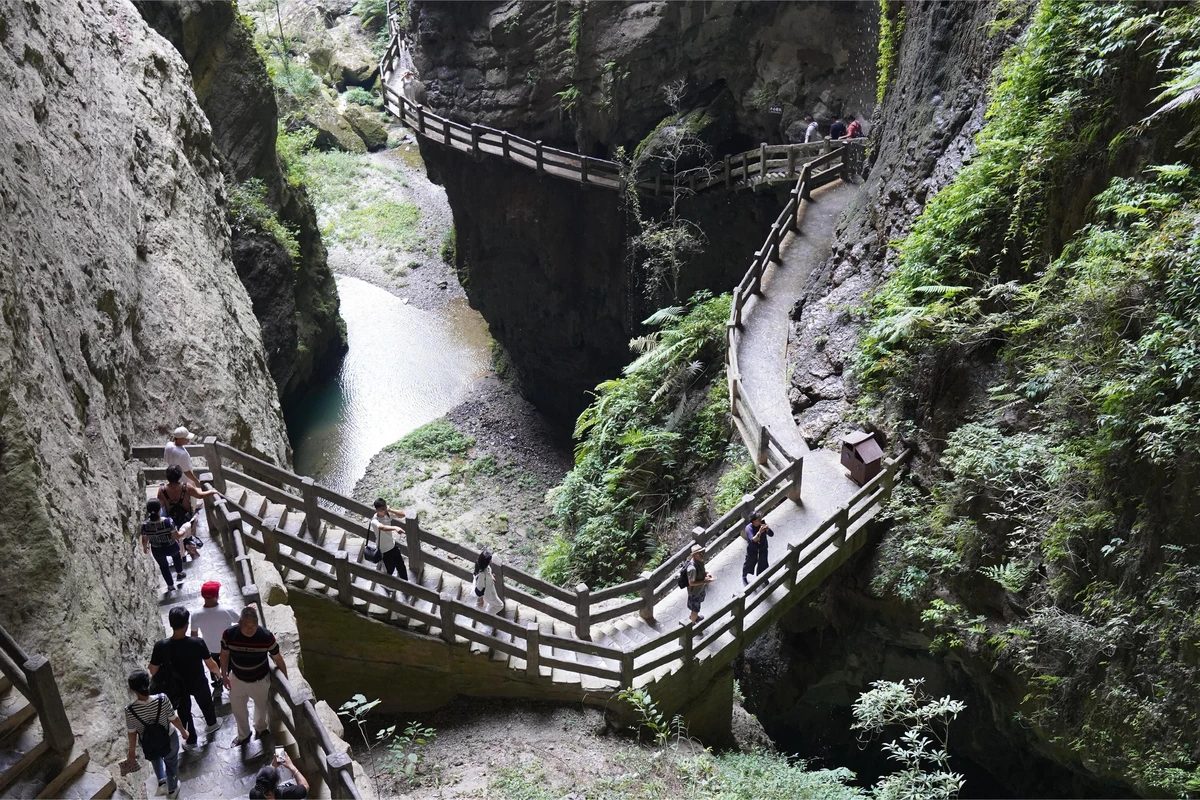
2. We walked down a steep stone staircase and saw two elevators. Queue lasted about 10 minutes.
We took the scenic elevator directly to the bottom of the tiankeng (elevator fee included in the ticket). The elevator is made of tempered glass, offering a view of the outside, but the 80-meter descent takes only 1 minute.
After exiting the elevator, there is a stone platform. Holding the railing, we looked down into the valley – a stone wall ahead, with stone steps cut through it leading to the bottom.
After a switchback staircase, we saw the Tang-style building "Tianfu Inn" at the bottom.
There is another viewing platform here, the best spot for shooting the "Tianfu Inn" from above.
Photo: Tang-style building "Tianfu Inn"
This "inn", costing tens of millions, was the filming location for Zhang Yimou's "Curse of the Golden Flower".
3. Along the quiet path at the pit bottom, we walked to the first natural bridge – Tianlong Bridge.
After descending to the bottom about a hundred meters, there is a T-junction. Tianlong Bridge is on the left.
At the T-junction, we turned left and passed under Tianlong Bridge.
Tianlong Bridge is 235 m high, 150 m thick, 147 m wide, with an average arch height of 96 m and average span of 34 m. Its height, width, and thickness rank second among the world's three natural bridges.
It is said that when you look back through the bridge hole, you can see an elephant striding forward on the cave wall at the entrance.
Many tourists were looking for this "elephant".
Photo: Tianlong Bridge
We passed under Tianlong Bridge again and returned to the T-junction, where a stone tablet reads 'Tianlong Bridge'.
4. Continuing forward, we arrived at the scene that appeared in the movie "Curse of the Golden Flower" – Tianfu Official Posthouse.
Tianfu Official Posthouse was built in the second year of Tang Wude (AD 619), located at the strategic point between "Zuantianpu" and "Baiguopu", an important posthouse for official information transmission between Fuzhou and Qianzhou in ancient times.
This road at the pit bottom is 5–6 meters wide, paved with stone slabs, a post road in ancient times suitable for wooden carriages.
"Tianfu Official Posthouse" is by the roadside, with a tiled roof, located between Tianlong Bridge and Qinglong Bridge.
Surrounded by dense forests, it is very quiet.
5. Not far past Tianfu Official Posthouse is Tianlong Tiankeng. Between Tianlong Bridge and Qinglong Bridge lies a pit surrounded by towering cliffs, majestic. Tianlong Tiankeng is about the size of two football fields, with a flat bottom.
Looking back at Tianlong Bridge, the two cliffs and a flat giant rock at the top form a rectangular bridge opening – a true natural stone bridge!
Photo: Bridge deck and opening of Tianlong Bridge
In the middle of Tianlong Tiankeng, there is a flat green area. On the green at the crossroads stands a giant dinosaur from Transformers 4, with teeth bared.
6. Following the crowd, we entered the second natural bridge – Qinglong Bridge.
Qinglong Bridge is the second natural bridge over the Yangshui River Gorge, also known as Zhonglong Bridge. It is named after the waterfalls cascading from the bridge deck after rain, creating mist and rainbows in the sunlight, like a green dragon soaring into the sky.
Qinglong Bridge is known for its height – 281 m above the water, the highest karst natural bridge in the world.
The lakeside here is a great place for photos.
Standing by the lake and looking through the bridge opening, the hole lets through light, resembling a big knife – handle and blade lifelike. The reflection in the lake looks like Guan Yu's Green Dragon Crescent Blade.
Photo: Big knife in the lake
Photo: Green Dragon Crescent Blade
After walking through Qinglong Bridge and looking back, the opening looks like a carp leaping over the dragon gate! The mouth, tail, and dorsal fin are vivid and lifelike!
Photo: Carp leaping over the dragon gate
7. Exiting Qinglong Bridge opening, we arrived at Shenying Tiankeng.
Shenying Tiankeng is surrounded by steep cliffs forming a rectangular shape.
Many attractions in the Three Natural Bridges scenic area require imagination to identify: the welcoming elephant at Tianlong Bridge, the Green Dragon Crescent Blade at Qinglong Bridge, the carp leaping over the dragon gate, and here the eagle spreading its wings…
The rock in the pit is the eagle's head, and the rocks on both sides are the wings – can you see it?
8. The section from Shenying Tiankeng to Qinglong Bridge is quite long.
Heilong Bridge: 223 m high, 107 m thick, 193 m wide, arch height 116 m, span 28 m. It ranks first in bridge width and average arch height among the world's three natural bridges, and third in bridge height and thickness.
Heilong Bridge is the last of the three natural bridges, named for its dark, deep arch hole, as if a black dragon winds along the top.
After passing under Heilong Bridge, there is a lake by the roadside.
Turn right onto a stone bridge, stop and look back at Heilong Bridge.
Photo: Lifelike gorilla head
Look carefully at the high part of the opening – do you see a huge gorilla head? This gorilla head with deep eye sockets on the cliff requires no imagination.
The gorilla guards Heilong Bridge.
9. Exiting Heilong Bridge, the river widens and the water flow increases, presenting a little Jiangnan landscape.
All three natural bridges are named after "dragon", expressing human awe and reverence for nature!
The entire route follows signs – no backtracking. Except for a few hundred meters of downhill into the Three Natural Bridges, the walk through the three bridges and two pits is mostly flat, about 4 km.
Ahead, we saw a large square – here begins the uphill out of the scenic area. Walking up takes about 20–30 minutes.
Almost all visitors queue for the electric cart running between the top and bottom of the tiankeng to the exit (¥15/person), a 7-minute ride.
It was 11:30 AM.
Total time for Three Natural Bridges: 2 hours 40 minutes.
The exit point of the electric cart is a large flat area with a row of food stalls under a canopy.
Shuttle buses here go in two directions: one back to the visitor center in town; one to nearby Dragon Water Gorge Ground Crack (requires a ticket for the ground crack to board).
We followed the staff's guidance and took the sightseeing bus to Dragon Water Gorge Ground Crack.
The bus ride took 10 minutes (8 km) to the Ground Crack scenic area.
This is another small square.
Perhaps it was lunchtime – we saw no staff.
We found the entrance to Dragon Water Gorge Ground Crack.
Visiting Dragon Water Gorge Ground Crack
Wulong Dragon Water Gorge Ground Crack is a sister scenic area to the Wulong Tiankeng, both located in the Yangshui River Grand Canyon,
but the scenery is completely different – it is a rare and mysterious ground crack landscape.
The scenic area is exquisitely carved. The ground crack gorge is 5 km long, with about 2 km accessible for walking. It consists of three sections: entrance crack, middle cave, and exit gorge.
The narrowest part is only 1 meter wide; the gorge depth ranges from 200 to 500 meters; cliffs soar thousands of meters on both sides, dangerous and steep. Inside, waterfalls and streams are constant, magnificent.
At the entrance of the ground crack, there is a deep cave. A wooden railing divides the path into two lanes.
Photo: Deep cave at the entrance of the ground crack
Exiting the cave, there is also a vertical elevator.
We took the elevator down to the mountainside, 80 meters above the ground.
From the elevator exit, we followed stone steps carved on the cliff gradually down to the bottom of the ground crack.
Both sides of the stone steps are rock cliffs.
After reaching the bottom, the plank road runs along a small stream.
During the wet season, the Dragon Water Gorge Ground Crack is full of waterfalls and flowing water on the rock walls, beautiful; the scenery greatly diminishes in the dry season.
There wasn't much rain this period, so the stream in the gorge was very shallow.
Photo: Stone plank road in Dragon Water Gorge Ground Crack
These waters come from underground rivers and flow year-round.
"In the tiankeng, you see mountains; in the ground crack, you see water." If you go after rain, walking through the ground crack, you'll see old trees entwined with vines, waterfalls hanging on the cliffs, water flowing at your feet on the plank road.
We reached a stone plank road hanging on the cliff. On the right side, the cliff protrudes to the left, forming a row of waterfalls above the plank road; the plank road itself is covered with water…
We opened our umbrellas to pass through this "Water Curtain Cave". The later part turned into a fine drizzle, about 30 meters in total – very magical and exquisite.
If you don't have an umbrella or raincoat, you'll get soaked.
The attractions inside the ground crack are all related to water: Dragon Pool Reflecting Moon, Milky Way Flying Waterfall, Dragon's Cold Grotto, Sacred Elephant Playing in Water.
Around a bend, we saw a waterfall – "Milky Way Flying Waterfall".
Photo: Milky Way Flying Waterfall
The Milky Way Waterfall forms four stepped drops, with the largest drop of 80 meters and a width of 2–3 meters.
Photo: Milky Way Waterfall
The waterfall can be viewed from several angles: a stone bridge, the plank road, and a viewing platform.
The scenery changes from different perspectives.
The path turned again, and we reached the "Sacred Elephant Playing in Water" attraction – a strip-shaped stone in the stream resembles an elephant's trunk.
Photo: Sacred Elephant Playing in Water
The final section of the scenic area is a plank road along the gorge, with relatively fast-flowing water.
We felt that the Ground Crack had more diverse scenery than the Three Natural Bridges.
Visiting the Dragon Water Gorge Ground Crack is a single route – you can't get lost.
The trip through the Ground Crack is relatively short, taking nearly 2 hours.
Visiting both the Three Natural Bridges and the Ground Crack took 5 hours in total.
At the exit of the scenic area, there is a large parking lot. Here we took a transfer bus back to the visitor center in Fairy Mountain Town. The bus departs only when full; the ride takes 20 minutes.
The drop-off point of the sightseeing bus is about 1 km from the visitor center parking lot.
We picked up the car at the parking lot. It was 3:00 PM.
Since it was still early, we decided to go to Fairy Mountain Forest Park.
We asked at the visitor center ticket counter, but the staff didn't specifically answer questions about the route to Fairy Mountain. Strange!
Fairy Mountain Forest Park is located north of Fairy Mountain Town (visitor center).
We navigated to Fairy Mountain Muti Visitor Center.
(Head northwest) Via Ginkgo Avenue and Wuxian Road (X154) to Fairy Mountain Forest Park – 17.2 km, 50 min, 4 traffic lights.
Visiting Fairy Mountain Forest Park
Fairy Mountain National Forest Park 5A
Address: Fairy Mountain National Forest Park, Wulong County, Chongqing
Ticket: ¥60/person (same price for peak and off-peak); seniors aged 65 and above: free.
Optional: sightseeing mini train ¥25/person.
Operating hours for optional items: 8:30–16:30
Parking: [Fairy Mountain Scenic Area Parking Lot] Address: Within Fairy Mountain National Forest Park, Chongqing Wulong; Spaces: 100; Reference price: free.
Fairy Mountain National Forest Park is a national AAAAA scenic area, located in Wulong District, Chongqing, with a total area of 8,910 hectares, an average elevation of 1900 m, a highest peak of 2033 m, 330,000 mu of forest, and 100,000 mu of natural grassland, with an average summer temperature of 22°C.
Fairy Mountain National Forest Park is known as the "Switzerland of the East" for its charming alpine meadows, snow-covered forests, and beautiful jungle landscapes.
Tip: Fairy Mountain Forest Park is at a higher altitude, with temperatures 4–7°C lower than at the foot of the mountain; weather is changeable, with large temperature differences between day and night. It is recommended to bring windproof clothing, umbrellas, and raincoats.
Starting from the Fairy Mountain Town visitor center, about 9 km later we reached the Fairy Mountain scenic area ticket office.
The ticket office parking lot consists of several parallel lanes, each with a gate at the front.
When we reached the gate, the staff checked our documents and registered our license plate number, after which we could drive further up into the Fairy Mountain scenic area.
From the ticket office, driving north 3.6 km, we reached the first stop – Ice and Snow City.
Whether you drive or take the bus into Fairy Mountain, the first attraction you reach is Ice and Snow City.
Opposite the Ice and Snow City is the camping base within Fairy Mountain.
North of the camping base is the Treetop Walk Camp.
It started drizzling.
At a fork ahead, there was a grassy area; we stopped by the roadside to wait for the rain to stop.
The rain didn't seem to stop.
We decided to head to Muti Visitor Center.
From Treetop Walk Camp, continue east 4.3 km to Fairy Mountain Muti Visitor Center.
Muti Visitor Center has a parking lot and ticket hall; private cars are not allowed further inside.
Fairy Mountain's most classic check-in spots over the past decade are the Wave Road and the prairie.
Muti Reception Center is the only way for visitors heading to the prairie and the horse track.
Visitors need to take the mini train or hike to the popular Wave Road and the prairie; further on is the horse track, a round-trip loop of about 10 km.
It was nearly 4:00 PM, and the rain was getting heavier.
We didn't want to give up, so we sat in the car quietly waiting for the rain to stop.
A large bus full of tourists arrived at the entrance parking lot. Two people who seemed to be the guide and leader consulted at the entrance, and then the bus drove away.
Across from our car, a passenger from a campervan looked up at the sky and then retreated back inside.
Photo: Campervan taking shelter from rain at Fairy Mountain
Our main purpose in coming to Fairy Mountain was to check in at the "most beautiful road", take a leisurely Thomas mini-train to the prairie, and fly a kite.
After traveling thousands of kilometers to get here, we didn't want to give up!
At 4:40 PM, the rain gradually stopped.
We immediately bought tickets for the Thomas mini-train at Muti Visitor Center. There were already over twenty tourists on the train.
The first stop of the Thomas mini-train is the prairie, the second is the racecourse, and the third is the horse field specially for those who want to ride (horse riding: ¥100/time).
The Thomas mini-train is actually a petrol-powered train towing a few carriages, designed to look like a small train; it does not run on tracks but on prairie roads.
Fairy Mountain Prairie Ecological Road is located in the core area of Fairy Mountain National Forest Park, built in 2009, 4.5 km long, known as "China's Most Beautiful Sightseeing Road".
The mini-train stopped at the prairie station. The conductor said the train would end here (perhaps it was the last trip).
The Nan Guo Prairie is located north of the station, accessible by a staircase path.
The prairie is very beautiful – a vast green meadow stretching far into the forest, with grazing sheep on the green grass.
Photo: Fairy Mountain Prairie
Perhaps because the sheep often interact peacefully with tourists, they actively approach visitors.
Photo: Sheep on Fairy Mountain Prairie
A little rain started again.
If the sun were out, we would have loved to lie on the grass and look at the sky.
Or fly a kite...
We have visited many prairies in China, and this one is among the most beautiful.
The last train was about to depart.
To catch the last Thomas mini-train, we couldn't fully enjoy the prairie.
Perhaps the driver wanted to compensate for the sections we hadn't covered, so instead of returning the same way, he drove to the horse farm and racecourse.
Along the roadside, horses of various colors were grazing leisurely on the grass.
Photo: Horse farm on Fairy Mountain
This undulating road runs through the park's grasslands and forests, with green grass on both sides, and cattle and horses leisurely walking and grazing – a pleasant and warm scene.
Heading west, this wave-like road offered endless beautiful views.
The highest peak of Fairy Mountain is 2033 m.
The last mini-train did not stop at the highest station.
The popular wave-like road is located between the prairie station and the racecourse station; the most beautiful section is near the racecourse station.
The mini-train didn't stop, so we could only take a quick look.
There is so much beautiful scenery in Fairy Mountain Forest Park.
On the way back to Treetop Walk Camp, we saw another herd of horses on the grass in a valley – about a dozen horses.
There were a few parking spots on this wide section of road; we stopped to watch the horses.
Photo: Road in Fairy Mountain scenic area
Photo: Horses returning at dusk
In the distance, at a three-way intersection about 30 meters away, a horse approached a young man, suddenly turned, and kicked its hind legs backward!
I was nervous and about to shout, but the young man quickly turned and ran, dodging the kick. Impressive!
This was the second time I saw a horse kicking with its hind legs.
Remember: Never walk behind a horse.
At around 6:00 PM, we left Fairy Mountain.
We drove down the mountain road to Fairy Mountain Town (30 minutes).
Entering a restaurant, some vendors pointed at the water stains on our car roof and asked if it had rained heavily on Fairy Mountain?
They told us there wasn't a single drop of rain down below.
Mountain weather is like this – "rain across the mountain".
There are many small restaurants in Fairy Mountain Town.
We visited three national 5A scenic spots in Wulong in one day – a great success.
We spent the second night in Fairy Mountain Town.
D4 (Sep 11, Monday): Return from Wulong to Chongqing; visit Hongya Cave and Chaotianmen in the afternoon (accommodation)
We left Fairy Mountain Town at 9:00 AM.
From Fairy Mountain Town Visitor Center (westbound) via Baomao Expressway to the hotel in Chongqing – 200 km, 3h20min, 6 traffic lights (toll ¥110) (passing 3 service areas).
We entered the hotel's underground parking lot at 12:30 PM.
We carried the luggage we had taken to Fairy Mountain Town into the room.
After a short rest, we went to Chongqing North Station to return the rental car.
We returned to the hotel at 2:00 PM.
Chongqing's night scenery is very distinctive.
We left the hotel at 4:00 PM.
As a fantastic city in China, Chongqing has many places worth visiting.
We came to Chongqing 15 years ago and visited Jiefangbei, Hongya Cave, and Ciqikou Ancient Town.
Tonight we wanted to see the beautiful night view of Hongya Cave and also check out the ongoing renovation of Chaotianmen Pier.
The hotel was 570 meters from the subway station (10 minutes).
We walked to Hongqihegou Station on Metro Line 6.
We took Line 6 to Xiaoshizi Station.
After exiting, we walked 654 meters, about ten minutes, to the south gate of Hongya Cave.
Chongqing's Yuzhong District is bordered by the Yangtze River to the south and the Jialing River to the north.
Buildings in this district are built into the mountains.
From Xiaoshizi Station to Hongya Cave, the 654-meter walk is mostly uphill or down stairs, and also requires crossing roads.
Hongya Cave south gate is separated from the Jialing River only by a road.
Pedestrian sidewalks on this section have railings on both sides, so you cannot cross the road.
Entering Hongya Cave from the south, you'll find various shops.
On the ground floor, there are several shops offering street photography services with photographers, makeup artists, and various costumes.
Hongya Cave Folk Custom Area is the top check-in spot in Chongqing, the only "three-dimensional walking street in the air" in China.
Hongya Cave is a great place to stroll through old mountain city streets, enjoy the views of the two rivers, and taste local food.
Hongya Cave Folk Custom Area 4A
Located on Cangbai Road in Yuzhong District, at the confluence of the Yangtze and Jialing Rivers.
It consists of four parts: Zhiyanhe Bar Street, Tiancheng Lane Bayu Style Street, Feast Food Street, and Exotic City Balcony.
Hongya Cave is backed by modern skyscrapers, creating a spectacular fusion of ancient and modern fantasy.
The Hongya Cave Folk Custom Area has 11 floors from the riverside road at the bottom to Cangbai Road at the top.
The top floor is the Exotic City Balcony, accessible by elevator.
From the viewing platform of the City Balcony, you can overlook the confluence of the two rivers.
Each floor of Hongya Cave has different content: restaurants, snack streets, bars and cafes, and local specialty shops.
Hongya Cave is free and open to the public; only the 1980s Block on the fifth floor and the Dreamy Bayu Twelve Scenes are charged.
With its stilted buildings full of Bayu characteristics, Hongya Cave is the number one check-in spot in Chongqing.
Today is Monday, a non-holiday, yet the cave was packed with tourists!
We wanted to reach the 11th floor's "City Balcony", where we could see the Qiansimen Bridge and the night lights of Jiangbei; looking down, you can also see the alleyways inside Hongya Cave.
There is an express elevator to the top floor on the north side of the main building.
We tried several times but the elevator was always full by the first floor.
We went to the east side of the building and saw escalators from 1st to 3rd floor, reaching the third floor.
Exiting on the third floor, we saw a narrow commercial street between the front and rear buildings.
Walking to the east end of the fourth floor of the south building, there is a platform with a few shops.
Passing through these shops and continuing east, there is a small uphill path crowded with tourists.
Next to the shops, there is a small platform.
Suddenly, the buildings lit up with colorful lights.
Hongya Cave lighting time: 20:00–23:00.
We suddenly realized that this platform was a great spot for photographing Hongya Cave at night!
We took a few photos – beautiful!
Photo: Hongya Cave
Photo: Night lights at the east end of Hongya Cave
We gave up on the idea of going to the 11th floor and left Hongya Cave through the south gate.
Walking east along the Binjiang Avenue beside the Jialing River from Hongya Cave for 200 meters leads to the south end of Qiansimen Bridge.
It is said that Qiansimen Bridge is the most beautiful internet-famous bridge in Chongqing at night, and the best spot for photographing the full view of Hongya Cave.
We saw that after lighting, Qiansimen Bridge resembled a red dragon.
Photo: Qiansimen Bridge at night
From Hongya Cave to Chaotianmen Square is only 1.3 km, a 30-minute walk.
It started raining, so we called a Didi to Chaotianmen Square.
The renovation of Chaotianmen Square won't be completed until the end of this year.
The car drove to the riverside road along the Yangtze River, but the security guard didn't allow entry.
The Didi had to go back and stop by the Jialing River.
Here, on the left, is "Raffles City".
From the east side of Raffles City, walk north along the Yangtze Binjiang Road to the "Two Rivers Cruise Ticket Office"; turn left and head west to the Jialing River bank. From there, walk north along the riverside road to "Chaotianmen Pier 6".
Chaotianmen is a landmark of Chongqing, the zero kilometer point; tourists must visit Chaotianmen to experience the real Chongqing.
Chongqing Chaotianmen Square is located in the northeast of Yuzhong District, at the tip of the Yuzhong Peninsula, at the confluence of the Yangtze and Jialing Rivers.
To the east of Chaotianmen is the grand Chongqing Grand Theatre in Jiangbei District; to the west is the brightly lit Nanbin Road in Nan'an District.
The night view of Chaotianmen is also very beautiful, with illuminated cruise ships particularly eye-catching.
Photo: Cruise ship at Chaotianmen
[On May 30, 2021, the 23-year-old Chaotianmen Gate in Chongqing began demolition! The renovation aims to restore the ancient gate, recreating the Bayu pass grandeur. The renovation of Chaotianmen Square is expected to be completed by December 31 this year.]
The nearest subway station is Chaotianmen Pier Station on Line 1.
The station is inside Raffles City.
Raffles City is a new landmark building in Chaotianmen, Chongqing, a high-end core CBD. A video of Chongqing's "Two Rivers and Four Banks" night scene went viral, with its sci-fi shape and dreamy lights, giving you a taste of what magical 8D Chongqing is like.
Exiting from Line 6 [Hongqihegou] (Exit 3), we saw many people standing or sitting (on the steps) – it was raining heavily outside.
Later we read in reports: From the night of September 11 to the day of September 12 in Chongqing, the central city had heavy rain turning to showers.
We tried to hail a taxi, but there were few shops near the station and no taxis in sight.
Although the hotel was only 570 meters away, we couldn't bring ourselves to go out in the rain.
We descended three floors of escalators back to the station hall to wait for the rain to ease.
After waiting about an hour, the rain continued. We had to walk in the rain along Hongmian Avenue back to the hotel.
The mountain city of Chongqing lives up to its name: the 500-meter pedestrian walkway is broken into segments no longer than 100 meters, with roads or alleys leading to higher buildings cutting through it. Rainwater cascades down these roads, making walking in the rain very uncomfortable...
(Today's driving: 200 km, 3h20min)
D5 (Sep 12, Tuesday): Chongqing - Xiamen
The weather forecast said it would rain these days.
With Chongqing's uneven roads and inconvenient travel in rain, we decided to return to Xiamen.
We had originally planned to visit Liziba Monorail Passing Through Building and Huguang Guild Hall, but we cancelled those plans.
Xiamen Airlines MF8492 Chongqing Jiangbei T3 13:40 – Xiamen Gaoqi T3 16:10 (Boeing 737-800)
A 2.5-hour flight, returning home smoothly.


