Encountering the Beauty of China: Experiencing Poetry and the Distant Horizon - Series on Traveling Across the Motherland, Part 1: Comprehensive Section (1) The Joys and Hardships of Hiking
Encountering the Beauty of China: Experiencing Poetry and the Distant Horizon - Series on Traveling Across the Motherland, Part 1: Comprehensive Section (1) The Joys and Hardships of Hiking
Shandong - Tai'an - Mount Tai
Shandong - Tai'an - Mount Tai
Heilongjiang - Wuchang - Snow Valley - Inn
Heilongjiang - Wuchang - Yangcao Mountain - Forest and Snow Field Scenery
Heilongjiang - Hailin - Snow Town
Heilongjiang - Hailin - Snow Town - Dreamland Home
Yunnan - Shangri-La - Middle Tiger Leaping Gorge
Yunnan - Shangri-La - Middle Tiger Leaping Gorge
Sichuan - Daocheng - Daocheng Yading Scenic Area
Sichuan - Daocheng - Daocheng Yading Scenic Area - Chonggu Meadow
Sichuan - Daocheng - Daocheng Yading Scenic Area - Milk Sea
Sichuan - Daocheng - Daocheng Yading Scenic Area - Luorong Pasture
Challenging Ourselves, Understanding Life, Experiencing the Joys and Hardships of Hiking – Sharing Hiking Routes, Experiences, and Reflections from Recent Outdoor Treks
In recent years, as people's living standards have steadily improved, travel has gradually become a part of everyday life for ordinary people and has increasingly become an indispensable part of many lives. Outdoor hiking is also gaining popularity among travel enthusiasts, with countless journeys of forward movement, crossing, and conquest taking place across the country. In particular, regular routes that do not require professional expertise but can be undertaken by ordinary travel enthusiasts, while also offering a chance to challenge oneself and experience the joys and hardships of hiking, are especially favored.
As travel enthusiasts ourselves, in recent years, based on our age, physical condition, and adaptability, we have chosen several unique, moderately challenging, and suitable hiking routes to try: ascending Mount Tai in Tai'an, Shandong; crossing the Forest and Snow Field (Yangcao Mountain) in Wuchang and Hailin, Heilongjiang; hiking the Middle Tiger Leaping Gorge in Shangri-La, Yunnan; and climbing to Milk Sea and Five-Color Sea in the Daocheng Yading Scenic Area in Sichuan.
These outdoor hiking routes include high mountains, deep valleys, plateaus, and snow fields. Each experience was different, with both hardship and joy, toil and sweetness. Although the time varied and the difficulty differed, the psychological journey was deeply moving and unforgettable. For us, who are older, such experiences are rare and leave lifelong memories.
Shandong - Tai'an - Mount Tai - Dai Temple
Shandong - Tai'an - Mount Tai - Flowers in Full Bloom on the Mountain
Heilongjiang - Wuchang - Yangcao Mountain - Forest and Snow Field Scenery
Heilongjiang - Hailin - Forest and Snow Field Scenery
Heilongjiang - Hailin - Snow Town - Dreamland Home
Yunnan - Shangri-La - Middle Tiger Leaping Gorge
Yunnan - Shangri-La - Middle Tiger Leaping Gorge - On the Hiking Trail
Sichuan - Daocheng - Daocheng Yading Scenic Area - Five-Color Sea
Sichuan - Daocheng - Daocheng Yading Scenic Area - People Climbing to Milk Sea and Five-Color Sea
Sichuan - Daocheng - Daocheng Yading Scenic Area - Chonggu Meadow
1. Climbing Mount Tai via the Classic Hiking Trail (Tai'an, Shandong, May 2016)
Mount Tai, majestic and magnificent, has been one of China's famous mountains since ancient times. It is known as the foremost of the Five Great Mountains and is a UNESCO World Heritage site for both culture and nature. The mountain features steep peaks and spectacular natural scenery. It also boasts numerous cultural relics, stone carvings, and religious temples. In spring, the mountain is covered with blooming flowers; in summer, it is lush green and pleasantly cool; in autumn, the leaves turn red and yellow, creating a colorful landscape; and in winter, rime ice often appears, making it extremely beautiful.
After years of operation, Mount Tai has become a well-developed tourist attraction. Visitors can reach the summit by hiking, cable car, or sightseeing bus. If you choose the cable car or bus, you can reach the top easily and quickly. For hiking, there are several trails, among which the classic hiking trail is more difficult but offers better scenery.
This classic trail starts from Red Gate, a path opened during Emperor Qin Shi Huang's imperial pilgrimage. Its main feature is numerous stone steps, including the long and steep "Eighteen Bends." From Red Gate to Mid-Heaven Gate, the trail passes through many attractions like Ten Thousand Immortals Tower, Doumu Palace, and Pot Heaven Pavilion, which also concentrate many stone carvings. At Mid-Heaven Gate, you can either take the cable car or continue hiking to South Heaven Gate and the summit area, visiting Cloud Step Bridge, Five Pine Trees, Gazing-at-People Pine, Ascending Immortal Platform, Eighteen Bends, South Heaven Gate, Heavenly Street, and Jade Emperor Peak.
Shandong - Tai'an - Mount Tai - First Heaven Gate
Shandong - Tai'an - Mount Tai - Cloud Step Bridge
Shandong - Tai'an - Mount Tai - Gazing-at-People Pine
Shandong - Tai'an - Mount Tai - Ascending Immortal Platform
Shandong - Tai'an - Mount Tai - "Only Supreme under Heaven" Stone Carving
Shandong - Tai'an - Mount Tai - Hiking Trail
Shandong - Tai'an - Mount Tai - South Heaven Gate
Shandong - Tai'an - Mount Tai - Flowers in Full Bloom on the Mountain
We chose the classic hiking route. At 9 a.m., we started climbing from Red Gate. Initially, we felt fine, walking and stopping to take photos. We reached Mid-Heaven Gate without much rest. Looking up at Mount Tai, we saw its towering peaks, undulating ridges, and spectacular scenery. After a rest and some snacks, we continued upward to the steepest part—the Eighteen Bends. This is the most perilous section of the Mount Tai hiking route, 800 meters long with over 1,600 stone steps, and is one of Mount Tai's iconic spots. The cliffs on both sides are as sheer as if cut by a knife, with the steep path inlaid between them. Looking up, the summit seemed far away, like a ladder to the sky. This is the hardest part to climb, leading to the saying, "The majesty of Mount Tai lies in the Eighteen Bends, and the grandeur of Mount Tai lies in the climb." By then, we were very tired, but we persevered. After passing the Eighteen Bends and reaching South Heaven Gate, we had conquered the steepest and hardest section, and victory was in sight. After resting at South Heaven Gate and Heavenly Street, we continued to the summit, arriving at 4 p.m.
This hike took seven hours to reach the highest peak, Jade Emperor Peak. Standing on top, we looked down at the surrounding peaks, feeling small, just like the poem says: "When I reach the top, I see that all other mountains appear small under the sky." From Red Gate to Jade Emperor Peak, we climbed over 8,000 steps, mostly high and steep stone steps. Honestly, we were extremely tired and sore, our legs almost uncontrollable, but we felt exceptionally happy and gratified!
Climbing via the classic trail is a significant test of willpower, perseverance, and physical fitness. For older people, it is a severe challenge.
Shandong - Tai'an - Mount Tai - Hiking Trail
Shandong - Tai'an - Mount Tai - Hiking Trail
Shandong - Tai'an - Mount Tai - People Climbing with Effort
Shandong - Tai'an - Mount Tai - Distant View of the Eighteen Bends
Shandong - Tai'an - Mount Tai - People Climbing with Effort
Shandong - Tai'an - Mount Tai - Flowers in Full Bloom on the Mountain
Shandong - Tai'an - Mount Tai - Jade Emperor Peak
Shandong - Tai'an - Mount Tai - Jade Emperor Peak
1. Many visitors who want to see the sunrise choose to climb Mount Tai at night. The Red Gate Visitor Center (entrance to the classic hiking route) is one of the few scenic spots in China open 24 hours a day.
2. If time and conditions allow, staying overnight on the mountain is a good choice. There are several inns and hotels near Heavenly Street and South Heaven Gate.
3. If you plan to hike, you need enough physical strength, endurance, willpower, and mental preparation. Buying a hiking stick at the foot of the mountain for a small amount will help a lot. Remember this.
4. During our climb, the mountain was covered with blooming crabapple flowers, which were gorgeous and added much to the scenery.
Shandong - Tai'an - Mount Tai - Flowers in Full Bloom on the Mountain
Shandong - Tai'an - Mount Tai - Flowers in Full Bloom on the Mountain
Shandong - Tai'an - Mount Tai - Flowers in Full Bloom on the Mountain
Shandong - Tai'an - Mount Tai - South Heaven Gate
Shandong - Tai'an - Mount Tai - Flowers in Full Bloom on the Mountain
Shandong - Tai'an - Mount Tai - Stone Carving
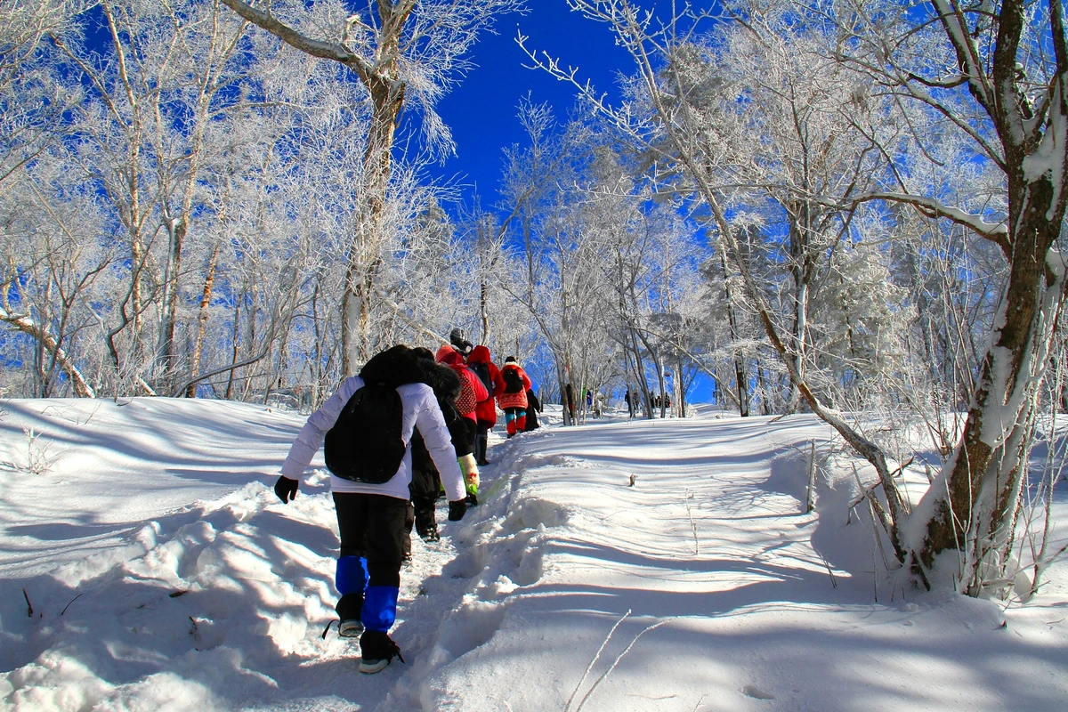
2. Hiking Across Yangcao Mountain (Forest and Snow Field) at over 1,200 Meters, from Snow Valley to Snow Town (Wuchang and Hailin, Heilongjiang, January 2018)
The hike from Snow Valley (Dongsheng Forest Farm, Wuchang City, Heilongjiang) to Snow Town (Shuangfeng Forest Farm, Hailin City, Heilongjiang) is mainly about snow hiking. Braving the bitter cold and treading through snow, we would follow forest trails to cross Yangcao Mountain (over 1,200 meters), commonly known as the Forest and Snow Field, and reach Snow Town on the other side. The distance is about 15 kilometers, and the journey generally takes 6 to 7 hours. This would be the most exciting, thrilling, yet toughest and most challenging day of our Heilongjiang and Jilin ice and snow trip in January 2018.
The night before the hike, it snowed lightly. The next day, the weather turned out to be excellent, with blue sky and some white clouds. Against the blue sky and white snow, the villages, fields, and mountains looked especially beautiful. We were extremely lucky to have such good weather for the hike, giving us southerners a rare opportunity to better appreciate the scenery and charm of the Forest and Snow Field in this icy world.
Heilongjiang - Hailin - Snow Town - Snow Rhyme Street
Heilongjiang - Hailin - Snow Town
Heilongjiang - Wuchang - Snow Valley - Yangcao Mountain - Forest and Snow Field Scenery
Heilongjiang - Wuchang - Snow Valley - Yangcao Mountain - Forest and Snow Field Scenery
Heilongjiang - Hailin - Yangcao Mountain - Forest and Snow Field Scenery
After getting up, we gathered our suitcases and had them transported to Snow Town. After breakfast at 8 a.m., we took a car to the crossing point more than ten kilometers away. There, we needed to buy tickets for Snow Valley. If we wanted to shorten the hike by several kilometers, we could spend 100 yuan to ride a horse-drawn sled. Some people were really great and insisted on hiking from the start. Among us, a few were older, so we decided to take the horse-drawn sled together to reduce the intensity. After about ten to twenty minutes on the sled, we officially started the 10-plus-kilometer hike.
Since Snow Town became famous, it has also boosted tourism in Snow Valley. Every day, many outdoor hiking enthusiasts and tourists hike from Snow Valley to Snow Town. As long as you follow the crowd, you won't get lost or face danger. Along the way, we chatted and laughed, stopping occasionally to enjoy the view and take photos, so we didn't feel particularly tired or miserable. By noon, we reached the summit and arrived at the visitor center on Yangcao Mountain, where we could rest and warm up indoors. There was hot water and restrooms. After a good rest, we ate instant noodles (15 yuan per bucket) and snacks we brought, spending about half an hour before lazily getting up and leaving. From there, we needed to buy tickets to enter Snow Town. Not far past the ticket gate, we were greeted by a vast snowfield with boundless scenery.
Thanks to the great weather, there was only a slight breeze on the summit, which usually had strong winds, allowing us to stop and admire the stunning scenery of the Forest and Snow Field. This area had sparse trees but thick snow, offering an open and magnificent view—truly pristine! Here, you forget all your fatigue and immerse yourself in this beautiful landscape. After enjoying the view and taking photos, we began descending. The descent was relatively gentle, and we moved much faster than on the ascent. At around 3:30 p.m., we reached the large stone marker of Snow Town and called the inn where we would stay to come pick us up. With everyone's efforts, the hike was a complete success.
Heilongjiang - Wuchang - Snow Valley - Horse-drawn Sled
Heilongjiang - Wuchang - Snow Valley - Yangcao Mountain - People Hiking
Heilongjiang - Wuchang - Snow Valley - Yangcao Mountain - People Hiking
Heilongjiang - Wuchang - Snow Valley - Yangcao Mountain - People Hiking
Heilongjiang - Wuchang - Snow Valley - Yangcao Mountain - People Hiking
Heilongjiang - Wuchang/Hailin - Yangcao Mountain - Visitor Center
Heilongjiang - Hailin - Yangcao Mountain - Forest and Snow Field Scenery
Heilongjiang - Hailin - Yangcao Mountain - Forest and Snow Field Scenery
Heilongjiang - Hailin - Yangcao Mountain - Forest and Snow Field Scenery
Heilongjiang - Hailin - Yangcao Mountain - Forest and Snow Field Scenery
1. Hiking from Snow Valley to Snow Town is a very popular outdoor activity in recent years. It's about the mindset and emotion, or a challenge and test of willpower and perseverance. Although it's called the Forest and Snow Field, the scenery along most of the route is quite monotonous. Only near the top and on the summit, where thick snow covers the vast snowfield, does the view become truly spectacular. Beautiful scenery often lies in remote and dangerous places. To enjoy such views, you must brave the freezing cold and long trek.
2. When hiking, minimize the items you carry, but a thermos with hot water is essential. In winter, temperatures there range from minus 10 to minus 30 degrees Celsius. Dress appropriately, with layers that can be put on or removed as needed.
3. On the ascent, there are several steep slopes in the middle of the mountain. You can only follow the footprints of previous hikers, stepping up step by step, which can be strenuous. On these sections, move slowly and steadily to avoid falling.
4. Crampons are very important. On the snow-covered path, where many people have walked, ice can form, making the ground slippery. Some steep slopes are also slippery. With crampons, your boots have better grip, making walking stable, especially when climbing up or down. There is often deep snow on both sides of the trail; for safety, generally avoid stepping there.
Heilongjiang - Wuchang - Snow Valley - Inn at Night
Heilongjiang - Wuchang - Snow Valley - Yangcao Mountain - People Hiking
Heilongjiang - Wuchang - Snow Valley - Yangcao Mountain - People Hiking
Heilongjiang - Wuchang - Snow Valley - Yangcao Mountain - Forest and Snow Field Scenery
Heilongjiang - Hailin - Yangcao Mountain - Forest and Snow Field Scenery
Heilongjiang - Hailin - Snow Town
Heilongjiang - Hailin - Snow Town - Dreamland Home
Heilongjiang - Hailin - Snow Town - Dreamland Home
3. Hiking the Middle Tiger Leaping Gorge (Shangri-La, Yunnan, May 2019)
In May 2019, we went on a 30-day road trip in Yunnan. During this trip, we visited many scenic spots, but one of the most memorable highlights was the hike in the Middle Tiger Leaping Gorge in Shangri-La. Its grandeur, steepness, and challenge left a deep impression.
The Tiger Leaping Gorge on the Jinsha River is famous for its danger, with high mountains, deep valleys, and steep terrain. It is one of China's deepest canyons. The gorge has an extremely narrow river surface, turbulent currents, massive rocks, cascading waterfalls, and a thrilling atmosphere. The gorge includes Upper, Middle, and Lower sections. The Upper Tiger Leaping Gorge is a national AAAA scenic area, well-developed, and often crowded with tourists. The Middle and Lower sections, as well as the high road hiking trail, are undeveloped and relatively dangerous areas. The geological structure is complex, the terrain is steep, and many places are in a primitive or semi-primitive state, with occasional rockfalls. For this reason, the high road hiking trail, particularly the Tiger Leaping Gorge hiking trail, is known as one of the world's top ten classic hiking trails, consisting mainly of the high road and the Middle Tiger Leaping Gorge trail.
The road from Upper Tiger Leaping Gorge to Middle Tiger Leaping Gorge is part of the Shangri-La East Ring Road, built along the Jinsha River. With high mountains, deep valleys, sharp bends, steep slopes, narrow roads, and some sections with potholes or fallen rocks on the side, this area is dangerous. Driving on these roads is quite nerve-wracking. Due to these factors, few tourists choose to come here, so there are very few vehicles on the road.
Yunnan - Shangri-La - Upper Tiger Leaping Gorge Scenic Area
Yunnan - Shangri-La - Upper Tiger Leaping Gorge Scenic Area
Yunnan - Shangri-La - Middle Tiger Leaping Gorge
Yunnan - Shangri-La - Middle Tiger Leaping Gorge
Yunnan - Shangri-La - Middle Tiger Leaping Gorge
Yunnan - Shangri-La - Middle Tiger Leaping Gorge - Scenery Along the Hiking Trail
Based on online introductions, and considering factors such as age, physical strength, and time, we chose the Middle Tiger Leaping Gorge hiking route, which is moderate in intensity and takes less time. It was said that experienced hikers could complete the round trip in just over 3 hours, but it actually took us nearly 5 hours.
At around 8 a.m. on May 25, the four of us arrived at the starting point of the hike, about 3 kilometers from the inn we stayed in the night before. After paying 15 yuan per person as a road repair fee to the local villagers (since the area is undeveloped and the villagers built the paths), we finally began the long-awaited Middle Tiger Leaping Gorge hike.
The Middle Tiger Leaping Gorge hike is quite primitive, with two main features. First, the terrain is steep and deep, with dangerous cliffs. The mountainside is sheer, and the west bank peaks rise over 3,000 meters above the river. The vertical distance from the roadside entrance to the river is over 1,000 meters. The mountain path is uneven, winding, and descends all the way, with some sections requiring climbing near-vertical ladders. With cliffs overhead and swift currents below, it's breathtaking. Second, descending is difficult, but ascending is even harder. The mountain path is rugged, with some places having wobbly wooden planks or tree trunks. The steps are very steep and primitive, making walking particularly strenuous. Whether going down or up, you often need to use both hands and feet, being careful not to slip. Two sections of ladders require strenuous climbing.
Yunnan - Shangri-La - Middle Tiger Leaping Gorge
Yunnan - Shangri-La - Middle Tiger Leaping Gorge
Yunnan - Shangri-La - Middle Tiger Leaping Gorge - On the Hiking Trail
Yunnan - Shangri-La - Middle Tiger Leaping Gorge - On the Hiking Trail
Yunnan - Shangri-La - Middle Tiger Leaping Gorge - On the Hiking Trail
Yunnan - Shangri-La - Middle Tiger Leaping Gorge - Climbing the Ladder
Yunnan - Shangri-La - Middle Tiger Leaping Gorge - The "Ladder" on the Hiking Route
Yunnan - Shangri-La - Middle Tiger Leaping Gorge - Climbing the Ladder
Today's hike in the Middle Tiger Leaping Gorge had excellent weather. The sun was shining, and the temperature was pleasant—around 20°C in the morning and nearly 30°C at noon, though a bit windy. We walked, climbed, rested, and took photos, spending over 2 hours to reach the river at the bottom of the gorge. We rested, admired the scenery, and took photos for another half hour before heading back around noon.
It is said that "beautiful scenery often lies in remote and dangerous places." Although the hike was tough, the scenery along the way was picturesque. The same Jinsha River and Tiger Leaping Gorge looked very different from various heights and distances. Especially when we neared the river at the bottom, we heard the roar of waterfalls and turbulent water from afar, which was awe-inspiring! After all the hardships, seeing the middle gorge with its numerous reefs, jagged rocks, treacherous rapids, and majestic waterfalls, we truly felt that all the effort was worthwhile. When you are there, its surging power not only amazes you but also deeply shocks you. You will marvel at the wonders of nature and feel delighted to have come here! The significance of this hike goes beyond that; it's about challenging yourself and enjoying the entire process!
On the way back, we climbed while resting, with two or three longer breaks. In just over an hour, we reached the entrance. At this point, the nearly 5-hour Middle Tiger Leaping Gorge hike ended successfully.
Yunnan - Shangri-La - Middle Tiger Leaping Gorge - Scenery Along the Hiking Trail
Yunnan - Shangri-La - Middle Tiger Leaping Gorge
Yunnan - Shangri-La - Middle Tiger Leaping Gorge
Yunnan - Shangri-La - Middle Tiger Leaping Gorge
Yunnan - Shangri-La - Middle Tiger Leaping Gorge - On the Hiking Trail
Yunnan - Shangri-La - Middle Tiger Leaping Gorge - On the Hiking Trail
Yunnan - Shangri-La - Middle Tiger Leaping Gorge
Yunnan - Shangri-La - Middle Tiger Leaping Gorge - Scenery Along the Hiking Trail
1. The Shangri-La East Ring Road has steep terrain, high mountains, deep valleys, sharp bends, steep slopes, narrow roads, and poor road conditions. When driving on this road, you must control your speed, concentrate, and drive carefully. Also, do not drive at night for safety.
2. There are several inns to stay at in the Middle Tiger Leaping Gorge area. You generally need to stay one night for the hike.
3. Don't bring too much water and food; carrying heavy loads is tiring. There are a few spots along the trail where villagers sell water and snacks. You can rest and buy a can of Red Bull, a bottle of water, or instant noodles.
4. It is said that a large company has taken an interest in the Middle Tiger Leaping Gorge and plans to invest heavily in building boardwalks, cable cars, and other tourist facilities, turning it into another tourist attraction. If true, this world-famous hiking trail will disappear. When everything becomes a thing of the past, if you miss it, it's gone forever.
Yunnan - Shangri-La - Middle Tiger Leaping Gorge - Scenery Along the Hiking Trail
Yunnan - Shangri-La - Middle Tiger Leaping Gorge - On the Hiking Trail
Yunnan - Shangri-La - Middle Tiger Leaping Gorge - On the Hiking Trail
Yunnan - Shangri-La - Middle Tiger Leaping Gorge
4. Daocheng Yading Scenic Area: Hiking from Chonggu Meadow at 3,900 Meters to Milk Sea at 4,600 Meters and Five-Color Sea at 4,700 Meters (Daocheng, Sichuan, October 2019)
Daocheng Yading – these four words seem to represent a signature attraction in Sichuan. Daocheng refers to Daocheng County; Yading refers to the Yading Scenic Area in Shangri-La Town, Daocheng County. Daocheng Yading is known as the "Soul of Shangri-La" and the "Last Shangri-La" due to its unique and pristine natural scenery. It is surrounded by three sacred peaks: the east peak Xiannairi (6,032 meters), the south peak Yangmaiyong (5,958 meters), and the north peak Xianuoduoji (5,958 meters), collectively known as the "Three Sacred Mountains of Daocheng." There are babbling rivers and lakes, vast meadows, and towering forests with colorful foliage. Coming here, you can "see the blue sky, white snow-capped mountains, golden meadows, and a fairy tale of autumn." It's so romantic, poetic, and captivating.
Because of this, and also due to the popular film "From Your Whole World" which used it as a location, Daocheng Yading has become one of the most popular tourist destinations in China in recent years. Travel enthusiasts, fans, and especially young people, flock here from all over, risking altitude sickness, as many areas are over 4,000 meters above sea level. During holidays, the scenic area has to implement crowd control measures.
Sichuan - Daocheng - Daocheng Yading Scenic Area - Luorong Pasture
Sichuan - Daocheng - Daocheng Yading Scenic Area - Chonggu Temple
Sichuan - Daocheng - Daocheng Yading Scenic Area - Distant View of Xianuoduoji Peak
Sichuan - Daocheng - Daocheng Yading Scenic Area - Yangmaiyong Peak
Sichuan - Daocheng - Daocheng Yading Scenic Area - Xiannairi Peak
Sichuan - Daocheng - Daocheng Yading Scenic Area - Pearl Sea
Sichuan - Daocheng - Daocheng Yading Scenic Area - Pearl Sea
Sichuan - Daocheng - Daocheng Yading Scenic Area - Chonggu Meadow
We were fortunate to join the crowd and visited Yading Scenic Area in late autumn 2019, attempting to challenge ourselves to climb Milk Sea at 4,600 meters and Five-Color Sea at 4,700 meters.
To facilitate our visit, we stayed in Yading Village. Early that morning, we went to the electric vehicle station above Chonggu Meadow and took a vehicle to Luorong Pasture. To save time and energy, taking the electric vehicle was necessary—round-trip cost 80 yuan; otherwise, there was a 6.8-kilometer boardwalk. After getting off, we walked along the boardwalk at Luorong Pasture, taking a few photos quickly before moving on. Further ahead, there was a viewing platform to see Yangmaiyong Peak (5,958 meters). Continuing, we reached a small uphill path. From Luorong Pasture, the surrounding scenery was very beautiful, like a series of spectacular paintings.
Soon after we started climbing, it was already noon. Like everyone else, we found a relatively sheltered spot by the trail, rested, and cooked self-heating rice we had brought for lunch, along with other snacks, to replenish energy for the challenge of climbing Milk Sea and Five-Color Sea.
During the hike, following the experience summarized by predecessors—"breathe every ten meters, drink every hundred meters"—we stopped every ten meters to take deep breaths and every hundred meters to drink a sip of water. We controlled our pace, so we felt fine. Along the boardwalk, trails, and steps, everyone walked and stopped, resting on the side to catch their breath, drink, and rest before moving on. Many people, especially young ones, held oxygen bottles and took occasional puffs. In the afternoon, the weather turned worse, with strong winds and temperatures around 3-4°C. Fortunately, we wore warm down jackets and wool hats to withstand the cold wind.
As we walked and climbed, we encountered steep steps, gravel paths, and water crossings. After climbing a steep slope known as the "Ladder," we saw a sign indicating the fork to Milk Sea and Five-Color Sea. According to experienced hikers, we should first go to Milk Sea. From the fork to Milk Sea was 1,000 meters with a relatively gentle slope. However, to Five-Color Sea, it was 740 meters of very steep stone steps built with primitive rocks, which would be extremely tiring. After reaching Milk Sea, the path to Five-Color Sea had a gentler slope and was easier. Five-Color Sea is the highest point ordinary tourists can reach. When descending, taking the 740-meter steep slope would be easier and less strenuous. This route significantly reduced the intensity.
Sichuan - Daocheng - Daocheng Yading Scenic Area - Luorong Pasture
Sichuan - Daocheng - Daocheng Yading Scenic Area - Luorong Pasture
Sichuan - Daocheng - Daocheng Yading Scenic Area - Milk Sea
Sichuan - Daocheng - Daocheng Yading Scenic Area - Five-Color Sea
Sichuan - Daocheng - Daocheng Yading Scenic Area - On the Climbing Trail
Sichuan - Daocheng - Daocheng Yading Scenic Area - On the Climbing Trail
Sichuan - Daocheng - Daocheng Yading Scenic Area - People Climbing to Milk Sea and Five-Color Sea
Sichuan - Daocheng - Daocheng Yading Scenic Area - On the Climbing Trail
After several hours of arduous trekking, we finally climbed to Milk Sea at 4,600 meters and Five-Color Sea at 4,700 meters. We all felt proud and thrilled to have overcome the severe challenges of high-altitude oxygen deficiency, steep mountains, fatigue, hunger, and cold. Looking at the beautiful lakes, we were filled with emotion. What a great challenge in life! This was also a rare experience and training!
The descent was much faster. Before long, we had returned to Luorong Pasture. This is one of the famous spots in the Yading Scenic Area, a pasture for local Tibetans. Surrounded by continuous alpine meadows, the Gonga River runs through it. Horses, cows, and sheep grazed leisurely on the meadows and slopes, creating a harmonious scene. After hours of continuous hiking and climbing, we could finally slow down, rest, and enjoy the beautiful scenery.
Starting at 10 a.m. from the electric vehicle station and returning around 5 p.m., we had hiked and climbed for over 7 hours, covering nearly 30,000 steps on the high plateau between 3,900 and 4,700 meters. This was the toughest and most challenging day among all our trips. Only by personally experiencing it can you truly understand what it means to have "eyes in heaven, body in hell"! The highest lakes, Milk Sea and Five-Color Sea, require arduous trekking and persistent effort to reach. But honestly, the scenery there was not really outstanding. The main purpose of the tough climb was to challenge our own limits, experience the ups and downs of the hike, and enjoy the sense of achievement and joy of reaching our goal.
Sichuan - Daocheng - Daocheng Yading Scenic Area - Milk Sea
Sichuan - Daocheng - Daocheng Yading Scenic Area - Five-Color Sea
Sichuan - Daocheng - Daocheng Yading Scenic Area - On the Climbing Trail
Sichuan - Daocheng - Daocheng Yading Scenic Area - On the Climbing Trail
Sichuan - Daocheng - Daocheng Yading Scenic Area - On the Climbing Trail
Sichuan - Daocheng - Daocheng Yading Scenic Area - On the Climbing Trail
Sichuan - Daocheng - Daocheng Yading Scenic Area - On the Climbing Trail
Sichuan - Daocheng - Daocheng Yading Scenic Area - Distant View of Yangmaiyong Peak from the Viewing Platform
Sichuan - Daocheng - Daocheng Yading Scenic Area - Luorong Pasture
1. The Daocheng Yading Scenic Area is large, with many scattered attractions. It is best to arrange 2 days or more for the visit. Autumn is the most beautiful season.
2. Accommodation options include Shangri-La Town and Yading Village. Staying in Shangri-La Town has two advantages: lower hotel prices (much lower than Yading Village) and lower altitude (2,900 meters, over 1,000 meters lower than Yading Village's 4,060 meters). However, from the scenic area gate (in Shangri-La Town) to Yading Village, there is over 30 kilometers of mountain road, requiring a nearly one-hour bus ride. Multiple round trips can be time-consuming and costly. Staying in Yading Village, inside the scenic area, is more convenient, but has two disadvantages: higher hotel prices (about double, even more during holidays) and higher altitude (over 4,000 meters). Choose based on needs and adaptability.
3. It is said that you can ride a horse up the mountain. The cost is 300 yuan per person, round trip taking 5-6 hours. There are only three groups of horses per day, 30 horses per group, with the earliest at 8 a.m. Riding a horse significantly reduces physical exertion, but drawbacks include long waiting times, inconvenience (you are not allowed to stay long at the top and are urged to return quickly), being asked to dismount on steep slopes, and the horses only go to Milk Sea, not Five-Color Sea. If you feel confident in your physical fitness and high-altitude adaptability, hiking is recommended. You can manage your time flexibly and have a deeper experience.
4. Many people online say there are no restrooms on the mountain, which was the case before, but now they are available. However, there are still no shops, so you need to bring your own water and food. Self-heating instant meals are a good choice.
Sichuan - Daocheng - Shangri-La Town
Sichuan - Daocheng - Daocheng Yading Scenic Area - Morning in Yading Village
Sichuan - Daocheng - Daocheng Yading Scenic Area - Five-Color Sea
Sichuan - Daocheng - Daocheng Yading Scenic Area - Chonggu Meadow
Sichuan - Daocheng - Daocheng Yading Scenic Area - Scenery Along the Climbing Trail
Sichuan - Daocheng - Daocheng Yading Scenic Area - Luorong Pasture - Scenery Along the Way
Sichuan - Daocheng - Daocheng Yading Scenic Area - Luorong Pasture
Sichuan - Daocheng - Daocheng Yading Scenic Area - Luorong Pasture
Practice has shown that outdoor hiking is not exclusively for the young. Older people can also actively participate and find joy, as long as their physical condition allows, they dare to try, proceed step by step, and choose hiking routes of moderate intensity.
Admittedly, life has many challenges. Some challenges must be faced, but others are self-sought, and the challenges of outdoor hiking belong to the latter. Many travel enthusiasts are keen on outdoor hiking to challenge themselves, train their will, and experience the joys and hardships. Of course, we should not be reckless or take risks just for thrills. We must choose suitable hiking routes based on age, physical condition, and adaptability to gain wonderful experiences and endless joy. Tired but happy—if so, life can be more colorful and meaningful!


