Fulfilling the Dream of Blue Hawaii
December 27, 2016 – January 3, 2017
My knowledge of Hawaii began with the hula dance. When I was a child, my father mentioned the hula dance with an admiring expression that I still remember clearly. The hula dance comes from Hawaii. In the early 1980s, I watched an English film called Blue Hawaii, which left a deep impression on me with its tropical scenery of the sea and beach, cocktails, hula dance, surfers, and floral shirts. From the film, I also learned that the place we call Tanxiangshan (檀香山) has another English name: Honolulu, a place full of fantasies for me. Amid our busy travel plans, Hawaii finally made it onto the schedule in the last few days of 2016.
This was a semi-independent trip, a small group of seven old friends. Because it was "semi" independent, the non-independent part required us to follow the travel agency’s arrangements and join another group of 17 people, following the itinerary set by the agency.
Our itinerary this time was 5 nights and 8 days. You might be a bit confused—there are 5-night-6-day trips or 5-night-7-day trips, but how could there be a 5-night-8-day trip? Here’s how it works: the first night’s assembly counts as one day, and the early morning departure the next day (crossing the International Date Line) counts as another day. Then we stay one night on Oahu Island, two nights on the Big Island of Hawaii, return to Oahu for two more nights, and then the flight back counts as another day.
Hawaii consists of over 130 volcanic islands, eight of which are inhabited. This trip to Hawaii covered two islands: Oahu, where the state government is located, and the largest island, Hawaii (also called the Big Island). The travel agency arranged the first day’s activities. For the remaining time, we could either arrange things ourselves or pay to follow local guides. After weighing the pros and cons, we decided to go with the flow and booked two local guide-led activities, leaving us with only one and a half days of true free time.
Let’s get moving!
December 27, 2016: Beijing to Honolulu, Hawaii
Gathered at Beijing T3 Terminal at 10 p.m. for Hawaiian Airlines flight HA898. No guide accompanied us. Our group of seven smoothly checked in and passed security. Following our usual habit, we brewed a bottle of hawthorn water to drink on the plane. Unexpectedly, there was another security check at the boarding gate, where all liquids had to be discarded or consumed. Helplessly, we stood at the gate drinking our water in a competition. The plane took off, quickly passing through the gray pollution layer to a sky full of stars—something we hadn’t seen in a long time. The plane was about two-thirds full, and everyone slept all the way to the destination.
Arrived around 4 p.m. local time on December 28 (18 hours behind Beijing time). Although entering the United States, the immigration process was simple. First, we lined up to use self-service kiosks (I recall there were more than ten machines). Families could do it together: scan passports, answer a few questions on the screen, take fingerprints as prompted, look at the camera for a photo, and the machine printed a paper with a photo, with a circle or cross that meant nothing (at least as far as we understood). Then we lined up again to hand that paper, the arrival card filled out on the plane, the passport, and a printed copy of the online EVUS approval to the customs officer, waiting for him to stamp it. Collected luggage, passed X-ray security, and entered smoothly. Honolulu Airport does not allow passengers to linger inside. As we walked out, we met our guide and finally saw the other half of our group.
The guide, surnamed Lin, from Fujian, gave us a classic introduction on the way from the airport to the hotel. Hawaii is the 50th state of the U.S., consisting of 132 islands, eight of which are inhabited, with a total land area of 16,700 square kilometers. Oahu (also called Waikiki? Actually Oahu is the island, Waikiki is a district) is the third largest island in the Hawaiian archipelago, with a land area of 1,554 square kilometers, and it is the most important island because the state capital, Honolulu, is located here. About 80% of Hawaii’s population lives on Oahu. Speaking of Honolulu (檀香山), one would think the name is related to sandalwood. Indeed, in the past—before the Chinese came to this place—there were many sandalwood trees. In the late Qing Dynasty, European-led Chinese laborers came here to cut sandalwood, and then many Chinese came to trade in sandalwood. Overharvesting led to fewer and fewer sandalwood trees, so now they are almost gone. Xiao Lin continued by sharing his own experience: his family is in the seafood business, mainly sea cucumbers. He came with his family at age 11 to various islands rich in seafood, almost all the islands in the South Pacific: Fiji, Tonga, Sabah, etc. He has been in Hawaii for over a decade. The reason for the change? You know: Chinese people are too hardworking.
The airport is close to the hotel. Our hotel, Maile Sky Court, is near Waikiki Beach and has two distinctive features: it is the tallest hotel in Hawaii with 44 floors, and there is a gas station nearby—the only one on Oahu. The hotel lobby is very interesting: the first floor has no walls, just large louvered doors surrounding it, somewhat like a fully open-style building in southern China. The rooms are not big but feel nice, newly renovated with all new facilities and very clean. The beds are unique—so high that shorter people have to make an effort to climb onto them. The room has a microwave and a coffee maker, so hot water is no problem.
Next came the so-called free time. All meals on this trip were at our own expense, so we had to solve dinner first.
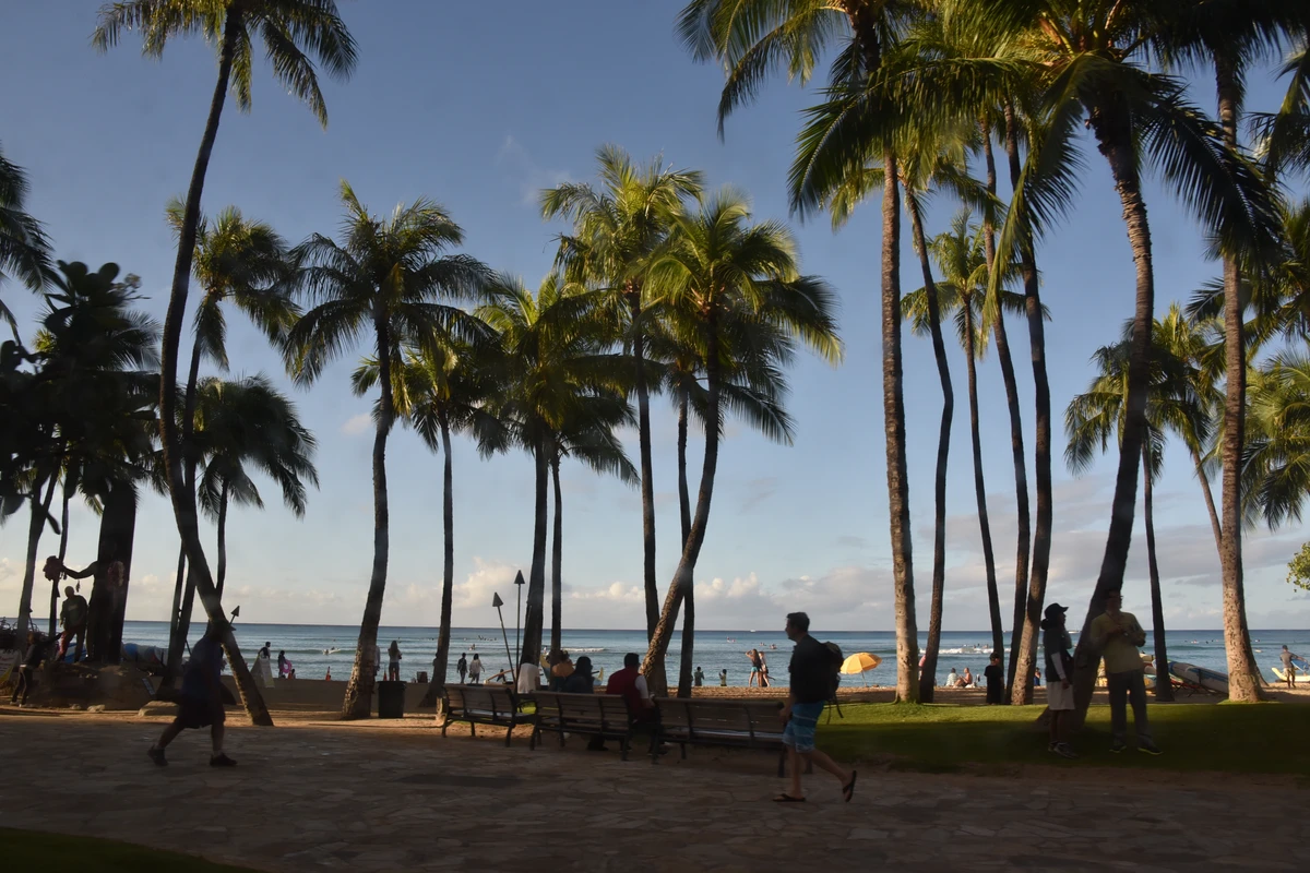
Left the hotel and turned left onto the main commercial street of Waikiki, named after a king and thus commonly called King’s Avenue. Brand stores, duty-free shops, and small supermarkets line the street. The side streets are mostly restaurants offering cuisines from different countries, with Japanese being the most common. Many places had long queues of tourists, likely following recommendations from travel guides. We didn’t join the crowd—what others praise may not suit our taste, and we wanted to save time for shopping. We chose a food court on the second floor of a mall recommended by the guide, mostly Southeast Asian food. We finally settled on a Japanese-style seafood noodle and beef noodle, averaging under $10. It was already past 8 p.m., and the streets were still bustling. The most distinctive features on both sides were the torches. Although streetlights were bright enough, every ten meters or so there were two burning torches fueled by natural gas. Every evening, someone lights them to preserve Hawaiian traditions. The crowded tourists, bright shops, and blazing torches created a lively atmosphere.
December 28: Half day on Oahu, then to the Big Island
Hanauma Bay, Blowhole, White Sand Beach, Pali Lookout—these were the morning attractions arranged by the travel agency. We drove along the coastal road early in the morning and saw a rainbow, actually a double rainbow. With humid air and the rainy season, rainbows are common here.
Hanauma Bay is about 10 kilometers east of our hotel in Waikiki, part of the Hanauma Bay Nature Preserve on Oahu. The bay is curved, and the rocks extending into the sea look like a dinosaur from afar, hence the name. From the slope, we could see people snorkeling in the bay. Hanauma Bay is a famous snorkeling spot on Oahu. The temperature this season is around 24°C, not really suitable for going into the water.
Next to it is a volcano called Koko Head (or Koko Crater? The text says "老人头火山" meaning Old Man’s Head Volcano). The folds on the mountain resemble wrinkles on an old man’s face. Early British explorers discovered and mined volcanic gems here, a green stone of low hardness called olivine. Old mining tracks still remain on the mountain.
The Blowhole is a seaside attraction where coastal reefs formed by volcanic activity have been eroded by waves, creating cavities. When waves surge in, they spout through these cavities like a fountain. Today the waves weren’t strong enough, so we didn’t see the spouting, but the erosion marks on the volcanic rocks were very obvious.
White Sand Beach: you might imagine blue sea and white sand, but not exactly. Hawaii is entirely volcanic; time hasn’t created enough natural sand. All the beach sand here is imported from outside the islands—man-made beaches. White Sand Beach is a surfing center; the “white” is not sand but white surf crashing on the shore.
Continuing north along the coast, we saw a small island to the right: Rabbit Island (also known as Chinaman’s Hat? Actually the text says "鲸鱼岛" (Whale Island) also called Rabbit Island, because the British once raised rabbits there). It looks like a whale from a distance.
Hawaii’s human history is not long. The earliest Polynesians arrived around 300 AD. The Kingdom of Hawaii was established in the early 19th century. In the mid-19th century, leprosy spread on the islands, along with venereal diseases, typhoid, and smallpox, reducing the population from 370,000 to 70,000. King Kamehameha V issued an isolation order, sending leprosy patients to Molokai. A priest named Father Damien voluntarily went to the island and served leprosy patients there for 16 years before dying of the disease. On that island, they discovered a plant that could be used for treatment: noni fruit. Noni is a unique tropical evergreen plant in Hawaii, seen everywhere. Its fruit has a distinctive shape and is said to boost immunity and lower blood pressure.
The guide took us to a local specialty store. We wanted to buy some noni capsules, but the promotional material indicated that you need to purchase a certain quantity for effectiveness. It felt like a bundled sale, so we skipped it and bought a batch of macadamia nuts instead. Lunch was still at our own expense—a dining spot at a golf course. For $11, we got a BBQ meal including grilled beef, pork, chicken, and rice—very generous, a bit too much for one person. The last scenic spot of the day was the Pali Lookout (大风口). It is located in the southeastern mountains of Oahu. This was the site of the Battle of Nuuanu in 1795, where King Kamehameha I defeated the Oahu chiefs during his unification campaign. During the battle, the chiefs, unable to withstand the king’s attack, fled here with no escape and jumped off the cliff to their deaths, along with hundreds of soldiers. Walking along a path toward the pass, the wind grew stronger. At the corner, a relatively open platform appeared; indeed it lived up to its name, “Big Wind Pass” (大风口). Everyone’s hair stood on end, and scarves and hats had to be held tight, or they would blow away.
This is a mountain pass where strong winds blow through, hence the name. From the platform, the view was expansive: nearby hills and green fields, distant houses and buildings, and even farther, the ocean.
On one side of the platform, a painting depicted the battle scene: one side showing the king’s army holding spears attacking the local people, the other side showing the nearly naked locals, unarmed, unable to resist, falling off the cliff.
The brutality of the war contrasted sharply with the peace of today.
In the afternoon, we flew to the Big Island to visit the volcano tomorrow. The Big Island is the youngest and largest island in the Hawaiian archipelago, so it is also called the Big Island. We stayed in the Hilo area on the east side of the Big Island, at the Hilo Seaside Hotel. It was only about 10 minutes from the airport to the hotel. Around a corner, next to a pond, stood a simple three-story building—that was the hotel.
The hotel looked very ordinary. When we got our room keys and checked in, we discovered it was a garden-style small hotel. The guest rooms were bungalows surrounding a small garden. Our room was in another courtyard with a swimming pool in the middle and a pavilion with rattan tables and chairs on one side—perfect for our evening gathering.
There was still some time before dinner. The guide who picked us up mentioned that the nearest small supermarket was about a 10-minute walk away. So off we went! It was already dark, and the streetlights were dim. Our group of seven walked along a road, noticing the tall banyan trees on both sides with dense aerial roots hanging down, giving a tropical feel. This street was actually a hotel area. The supermarket was very small, with nothing special to buy, but we had to get some local alcohol. It started to drizzle. We had originally hoped to see the stars on the Big Island—almost every Big Island travel guide mentions the starry sky—and I had even brought a tripod specifically for that. But at least tonight we didn’t have to worry about it. Back at the hotel, we just ate and drank! We had roasted chicken bought on Oahu, vegetable salad, Chinese broad beans brought from home, homemade cookies, various tofu puffs, instant noodles, and freshly bought local beer and wine. We set up a lively table. Most importantly, these seven old friends, regardless of what food was available, would always have endless things to talk about when together.
Several downpours occurred during the meal. Beside us was the swimming pool, surrounded by green plants. Rainwater streamed down from the edges of the pavilion, dripping onto the plants. Sitting under the pavilion, we felt even more cozy.
Thus passed the first night on the Big Island. I hope it doesn’t rain all day tomorrow.
December 29: Full day on the Big Island
Today was the highlight of the trip: visiting the Big Island. The first thing on the bus, the guide showed us today’s itinerary: Black Sand Beach, Rainbow Falls, Orchid Garden, and Hawaii Volcanoes National Park. The Big Island was formed by volcanic eruptions from the seafloor about 700,000 years ago. It is the last island formed in the Hawaiian archipelago, with a total area of 10,414 square kilometers—twice the area of all other Hawaiian islands combined—hence the name Big Island. There are still active volcanoes on the island, constantly erupting lava, so it is also called the Volcano Island. Our first stop was Black Sand Beach. As we drove along the banyan tree avenue we had walked the night before, these banyan trees are over a hundred years old. The weeping fig (垂叶榕) can only be planted in the second row, because if planted in the front, their hanging branches would obstruct traffic and require constant trimming. We saw stilt houses near the coast because Hilo Bay is U-shaped; when a tsunami strikes, it can cause severe damage. In 1946 and 1960, two severe tsunamis occurred here. Since then, the government has required all houses near the coast to be built on stilts, with the first floor unoccupied. We arrived at Black Sand Beach. Although called Black Sand Beach, the fine sand here has three colors: black, green, and white. Black is crushed volcanic lava eroded by seawater over time; green is olivine crystals from volcanic eruptions; white is crushed seashells from the seafloor.
The sand felt very soft underfoot. The beach area is not large, but we saw more black rock flows heading toward the sea. Volcanic lava erupted from the crater, rapidly cooling and solidifying upon contact with cold seawater, forming unique rock folds that look very dynamic, as if still moving slowly. There were also huge black volcanic rock reefs with cracked crevices, evoking the image of cataclysmic changes and rumbling sounds of the time. Now everything is calm.
In a stream near the shore, we could see sea turtles. Beyond the rocks, huge waves kept crashing against the shore. I wanted to go over and look.
As I stepped over a few rocks and was about to reach the other side, before my left foot landed, my right foot stepped on a loose rock. My left foot slipped straight into the water. Holding my camera in my left hand and an umbrella in my right, I knew I would inevitably fall. I tried to sit down slowly into the water, but my left foot still got caught—a slight sprain. This was only the first scenic spot of the day and just the beginning of the trip. Bad start. Fortunately, the sprain wasn’t severe; I could still manage. My wet pants and shoes had to be tolerated. We passed through the small town of Hilo on the island and headed to Rainbow Falls. Along the way, the guide introduced the town. Hilo doesn’t have a long history; the old town is about 100 years old. There are about 300 Chinese on the island, and a restaurant called New China Restaurant is actually run by a Filipino, serving American-style Chinese food.
On this island, all streetlights are yellow because there is an observatory on the island; the town’s lights must interfere as little as possible with the observatory’s work. The Hilo area has a small population, few shops, and not many places to spend money. People are used to sleeping after dark. The weather was overcast all day, with occasional rain. When we reached Rainbow Falls, the rain suddenly became heavier. The waterfall faces east; although not large, under sunlight it always forms a beautiful rainbow, hence the name. Today, we could only see the waterfall, not the rainbow.
This area is also black volcanic rock. Across from the viewing platform, a waterfall cascades into a deep pool, surrounded by rainforest. Two huge century-old mango trees stand side by side. Monstera (龟背竹), which is pampered at home, grows freely here by the rocks.
We could climb a stone stairway up the hillside to see the top of the waterfall. My left foot started to hurt. Considering the many roads ahead, I decisively gave up the idea of climbing and just looked around.
The rain intensified; even my umbrella started to leak from the center. What was going on? Was 2016 a year of water? During almost all our trips this year, rain accompanied us. In the past, we never carried umbrellas, but now umbrellas have become essential. Fortunately, the rain came and went quickly. We left the waterfall and went to the Orchid Garden for lunch as the rain stopped.
Lunch was arranged at the Orchid Garden, a buffet for $18 per person, with free entry to the garden. There were various orchids and outdoor tropical plants.
Here we saw Hawaii’s state flower, the yellow hibiscus (黄芙蓉). By the way, Hawaii’s state tree is the kukui; the state bird is the nene, a flightless goose; and the state fish has a very strange name: Humuhumunukunukuāpuaʻa (shortened as “Humuhumu”), also known as the triggerfish. It truly looks unusual—there are photos as proof.
In the afternoon, it was time to visit Hawaii Volcanoes National Park. There are currently two active craters on the Big Island: Halemaʻumaʻu Crater (over 4,000 meters elevation? Actually it’s a pit crater within Kīlauea Caldera, elevation around 1,200m? The text says 4000+ meters for Halemaʻumaʻu? That might be a misunderstanding; Halemaʻumaʻu is about 1,200m? Well, I'll keep as translated) and Kīlauea Crater (1,200 meters elevation). Both are within the national park. It didn’t take long to drive to the volcano park. The sky was overcast. In the distance, there were no tall plants, only fine black gravel on the ground. After getting off the bus, to the left was a vast flat area—the summit. In the distance, a crater emitting white smoke was Kīlauea Caldera. Unlike cone-shaped volcanoes, Kīlauea is a shield volcano; the crater forms a step down from the summit plain.
With a telephoto lens on my camera, I could see red light in the boiling crater (it would be even better at night). This is the most frequently erupting volcano in the world and the youngest. It first erupted in 2008, and the crater now has a diameter of 300 meters. According to local legend, the fiery volcano goddess Pele lives in Halemaʻumaʻu Crater, often fighting with her sister, the sea goddess. Their battles cause landslides, dark skies, and the scattering of the goddess’s hair and tears. “Hair” and “tears” are displayed in the adjacent Thomas Jagger Museum; actually, they are products of volcanic eruptions—mineral crystals ejected at high temperature, slowly cooling into threads or droplets.
The exhibition room introduces volcanic legends and displays local volcano monitoring data and various materials, including a video showing real-time satellite monitoring of the crater.
A large photo shows the past, present, and future of the Hawaiian Islands formed by volcanic eruptions. The photo highlights the world’s two most active volcanoes on the southeastern part of the Big Island: Mauna Loa and Kīlauea. Their exposed height above sea level is not high, but they erupt directly from the seafloor. If you add the submerged base, they should be the highest mountains in the world. Hotspot underground volcanic lava erupts through several fixed vents. The erupted lava meets seawater, cools into rock, and the land formed by this rock drifts northwest as the Earth rotates, creating the Hawaiian Islands: Kauai, Oahu, Maui, etc. As these islands drift away from the hotspot, the volcanoes become extinct—that is their past. Currently, the volcanic conduits under the Big Island are still active, two of which lead directly to the craters: Halemaʻumaʻu and Kīlauea. Because they continuously pour out lava, the Big Island’s area grows at a certain rate each year—this is its present. The future of the Big Island: as the volcano continues to erupt, land area will further increase, or one day the underground magma may accumulate enough energy for a huge eruption, creating a new island.
Monitoring volcanic activity is very important here. In the volcano park, you can see steam (or smoke) rising from cracks in the ground everywhere, reminding you that they are alive.
We took a bus to a scenic spot in the park: a volcanic lava tube. It formed after a violent eruption. Huge volcanic lava flowed from the summit to the sea. As it flowed, the surface gradually cooled and formed a hard crust, while the hot interior continued flowing. As the eruption waned, no more lava followed, leaving a long tunnel—the lava tube we see. Now the entrance is covered with tropical plants. Cycads (sō? actually tree ferns and ferns are everywhere. The text says “娑椤” which might be a type of tree fern or cycad? We’ll just say “sago palms” or keep as “cycads”? Better: “cycads and ferns”. We crossed a small bridge, and the tunnel appeared before us. The diameter was large; if not told, one would think it was man-made. The surface was relatively smooth, winding for less than 500 meters. It’s hard to imagine the sight of hot lava flowing here.
Evening was still overcast, so no stargazing. My foot sprained in the morning hurt more after a day of walking. At night, I applied medicated patches, changing them every two hours, hoping to walk normally tomorrow. The others went shopping. They said they walked along dim streets for about 50 minutes to find a mall—very hard.
December 30: Free day on Oahu
Flew back to Oahu from the Big Island in the morning. Felt like returning to modern society. Checked into the same hotel and found that the lobby had moved and the louvered walls were gone. It turned out everything was temporary; the hotel was under renovation. Check-in wasn’t until 3 p.m., so we went to eat first.
We wanted something hearty and found a seafood restaurant called CRACKIN. The big crab on the sign whetted our appetites.
Although Hawaii is an island, to protect natural resources, fishing and coastal aquaculture are not allowed. All seafood here is imported, so prices are not cheap. We ordered a king crab set for 4-5 people and a lobster set for 2-3 people. For drinks, we naturally chose the cocktail “Blue Hawaii”. The men chose sangria with liquor. We waited for the food! The restaurant service was unique: each person got a bib. We obediently put them on, took a photo, but there were no utensils. In a bucket on the table were disposable gloves and plastic forks—so we were supposed to eat with our hands!
The cocktail arrived. Oh, the Blue Hawaii cocktail is not blue but green. It’s made with lychee liqueur, pineapple, Blue Curaçao, and tonic water, with a small piece of pineapple on top. It was sweet with a mild alcohol taste—very nice.
The waiter carried a large iron pot. That was the king crab set. A huge king crab sat on top, surrounded by lobster, large shrimp, various shellfish, octopus, corn, ham, and underneath, rice soaked in broth and various sauces. Then came the lobster set, which was quite unusual: the waiter carried two big plastic bags and directly dumped the food onto the table. Only then did we notice that the tablecloth was actually a big napkin! No plates needed. The two preparations looked mouthwatering. Without further ado, we dug in. So delicious!
After we finished most of the crab and shrimp, we reached into the pot for the rice. Wow! It was scorching hot! The rice had absorbed all the fats and juices from the seafood—incredibly flavorful! This wasn’t meant to be eaten with hands, was it?! After eating and drinking our fill, we went to check in, watched the sunset at the beach, then went shopping. In the evening, we gathered again: salad, canned food, instant noodles, a little drink, chatting until midnight, then dispersed. Another day passed: eat, shop, eat, shop.
December 31: Pearl Harbor nostalgia
Today was free time, and we planned to go to Pearl Harbor—a must-see in Hawaii. We set out around 8 a.m. to catch the bus. Bus 42 was not far from the hotel; fare $2.50 direct. The bus driver was a dark-skinned woman who looked serious. After confirming our destination with her, we sat at the back. The bus was empty, with seats similar to reserved seats for the elderly and disabled. At one stop, the driver opened the door, stood up, and lowered a ramp. A passenger in a wheelchair wanted to board. The driver flipped up the reserved seats to make space for the wheelchair, helped the passenger on, and secured the wheelchair. All of this was done naturally without anyone saying a word. Other passengers waiting to board politely waited until the driver returned to her seat to pay and board. No one rushed or was impatient. This scene left a deep impression. The bus stops here have no names. If a passenger wants to get off, they pull a wire next to the window, and the driver will open the door.
The ride from the hotel to Pearl Harbor took about 40 minutes. I felt we were close, so I went to the front to confirm with the driver and asked her to remind me. She nodded without turning around. At an intersection, she stopped, turned to me, and said that the next stop was ours. She told me that the bus would turn and stop, but if we wanted to take the same bus back, we shouldn’t wait at this stop but at that intersection. I was very grateful—she even thought about where we should wait for the return trip. Although her expression was serious, she had a kind heart—simple folk customs. At the Pearl Harbor Visitor Center, tickets for several paid attractions could be purchased, and free tickets for the USS Arizona Memorial were available, but only about 1,000 free tickets were given out daily starting at 7 a.m. By now, they were surely gone. We bought tickets for the USS Missouri Memorial ($27/person). This is a U.S. Navy base; no bags are allowed inside. Baggage storage cost $3 per item.
We took the shuttle bus to the USS Missouri Memorial. The memorial is the battleship Missouri itself.
At the entrance to the battleship stood a statue of Fleet Admiral Chester W. Nimitz, commander of the Pacific Fleet during WWII, with his inscription: "They fought together as brothers in arms; they died together and now they sleep side by side."
The huge battleship was docked. We boarded. Free Chinese-speaking docents were available by reservation. The docent led us to the deck first to introduce the basics: the USS Missouri was launched in 1944, the largest battleship ever built in U.S. history. During WWII, it participated in the Battle of Iwo Jima, the Battle of Okinawa, and operations against the Japanese mainland. On September 2, 1945, the Missouri, anchored in Tokyo Bay, served as the site of the Japanese surrender, marking the official end of WWII. It later served in the Korean War in 1950, was decommissioned in 1955, recommissioned in 1986, and participated in the Gulf War in 1991. It was decommissioned again in 1992, and in 1999, it returned to Pearl Harbor as a memorial. The battleship has nine main guns in three turrets, capable of firing one-ton projectiles to hit targets about 40 kilometers away in 1.5 minutes.
During the Gulf War in 1991, this ship fired the first Tomahawk missile at a target. On the side of a turret was a small map of Iraq, with the number of shells fired by that gun during the war.
The deck is made of wood—originally I thought battleship decks were steel. The Missouri’s deck retains some original wood from 1944, some replaced in 1986, and the latest sections. The most commemorative part is on the starboard deck. A copper circle encloses a spot with a brass plaque under glass: "On September 2, 1945, at this location, Japan signed the instrument of surrender to the United States and Allied Powers, marking the end of World War II. At that time, this ship was anchored in Tokyo Bay." Below, the latitude and longitude of that point are marked.
Admiral Nimitz sat at a table behind this spot to accept the Japanese surrender. Representatives of the Allied powers signed the surrender document in order. The Republic of China’s representative, General Xu Yongchang, signed for China. Because the fifth signatory, Australia, signed in the wrong place, the subsequent signatures were all misaligned. The Japanese requested a re-signing, but no one paid attention, so they had to leave with a flawed document. On one side of the deck, a replica of this historic document is displayed. The original is in the U.S. National Museum.
On the side of a turret near the deck, a photo from that time recreates the grand scene.
On the starboard quarter, there is a dent—the only damage the Missouri suffered during the war, caused by a Japanese kamikaze plane that crashed into the ship.
The Japanese kamikaze pilots were like human bombs, carrying one bomb and just enough fuel for a one-way trip—a certain death mission. On the starboard deck, there are also several footprints marked leading off the ship. This has a story: during WWII, a Japanese kamikaze pilot crashed onto the ship, fell from the plane onto the deck, and died. The captain ordered the crew to give him a burial at sea with military honors. The footprints mark where the coffin was carried. Decades later, Japanese tourists heard this story and were moved. They searched for information about the pilot back in Japan and found out that he was a boy under 17 years old, conscripted into the kamikaze corps. A photo of him with his family is displayed. If not for the war, he would have lived a peaceful life with his family.
After the guided tour, we entered the interior of the ship following the route, visiting the crew’s work areas, living quarters, officers’ quarters, and recreation areas. Many areas are preserved as they were, and many places have been turned into exhibition rooms with photos and artifacts, giving a tangible sense of life on a battleship.
Back on deck, in front of us was a long white building: the USS Arizona Memorial. Below that building lies the famous USS Arizona, sunk during the attack on Pearl Harbor. On December 7, 1941, at around 8 a.m., Japan launched a surprise attack on the U.S. Pacific Fleet base at Pearl Harbor. Within 1.5 hours, they sent over 300 aircraft in two waves, severely damaging the unprepared U.S. Navy. The attack killed over 2,300 Americans, sank five of eight battleships in port, including the Arizona, which went down with 1,177 officers and men. This event, known as the Pearl Harbor attack, drew the United States into World War II. The sunken Arizona was not salvaged; the bodies of the men who died with the ship still lie on the seafloor, as Admiral Nimitz said, “They fought together… and now they sleep side by side.” From the Missouri, you can clearly see oil slicks floating on the water from the leaking fuel of the Arizona.
We returned to the Pearl Harbor Visitor Center by shuttle. Nearby is the Submarine Museum, where the USS Bowfin, a submarine that served in WWII, is docked. We didn’t buy tickets but browsed outside. Torpedoes were displayed everywhere, and in a circular area stood a ring of stone tablets—the Submarine Memorial. During WWII, 288 submarines were deployed; the tablets list the photos and briefs of those that were lost.
Walking along the waterfront, we saw a huge anchor—the anchor chain from the USS Arizona.
Along the shore, a series of interpretive panels detailed the Japanese air raid routes and the devastation of Pearl Harbor on December 7, 1941.
Over 70 years later, this place is peaceful—a stark contrast. Such is the shock of history. We returned to the hotel. It was the last day of 2016. Due to the time difference, we had already sent New Year’s wishes to friends back home the day before. Here, New Year’s Eve was still a few hours away. First, we went shopping; the stores closed early. Then we went to the beach to wait for fireworks. By midnight, nothing happened. We gave up, went back to pack and wash up. We were flying home tomorrow night. At midnight, we heard continuous fireworks outside. On this Pacific island, we stepped from 2016 into 2017.
January 1, 2017: New Year’s Day on Oahu
Today was supposed to be free, but to save trouble and see more places, we bought a local tour: the Grand Circle Island Tour, including Zhang Xueliang’s grave, Chinaman’s Hat Island Park, Kualoa Ranch, Sunset Beach, Haleiwa Town, and Dole Pineapple Plantation. Finally, we were dropped off at the only outlet on Oahu for shopping, then to the airport. It looked like a good itinerary. In the morning, we boarded the bus and drove northeast along the coast, gradually entering the mountains. We passed two famous high schools. One is well known because two famous people studied there: Sun Yat-sen and Barack Obama. Initially, most Chinese in Hawaii came from Zhongshan, Guangdong, working with Europeans to cut sandalwood. After their three-year contracts ended, many found business opportunities and stayed. Sun Yat-sen’s older brother was one of them, later becoming wealthy and funding Sun’s revolutionary activities. The other high school, not far away, is among the top ten in the U.S. for education. It was founded by a local wealthy man and only admits students with at least one-quarter Hawaiian blood. There are fewer than 2,000 pure-blooded Native Hawaiians today, so they value bloodline preservation. The first stop was to visit Zhang Xueliang’s grave. His grave is on a hillside within a cemetery.
Entering the cemetery, you could see clear differences between Eastern and Western cultures. Chinese graves face the sea (facing home across the ocean), while local Hawaiian graves lie flat on the grass facing the sky (for easier conversation with God).
After gaining his freedom, Zhang Xueliang first went to Long Island to stay with Soong Mei-ling. He came to Hawaii mainly because his younger brother was here, and later moved into a nursing home. His ex-wife Yu Fengzhi not only supported him financially but also built this grave for him. For a divorced couple to do that was extraordinary. Chinaman’s Hat is a small volcanic island protruding from the sea, very close to the east coast. Its name is “CHINAMAN’S HAT.” The guide told a story: legend says that Chinese men are strong, hardworking, and big eaters, eating from land to sea. They discovered a dragon at the bottom of the sea, bent down to hug it, and only a small straw hat remained on the surface. The story is obviously made up, because from afar, anyone can recognize it as a small straw hat floating on the sea.
On the beach here, we saw coral and shells washed up by the waves. In the coastal woods, various birds gathered, one very beautiful with a red head, white belly, and gray wings—a California red-headed warbler? Actually, it might be a red-crested cardinal or something. I’ll translate as “California red-headed warbler” but keep as is from the original.
Across from Chinaman’s Hat Park is Kualoa Ranch, backed by volcanic mountains covered with ancient monkeypod trees. Over 20 movies, including Jurassic Park, Godzilla, and Tora! Tora! Tora!, were filmed here. This should have been the highlight of today’s tour, but because it was New Year’s Day, the ranch was closed. Regretfully, we could only take some photos outside.
To fill the time, the guide took us to visit the Mormon Temple near Brigham Young University–Hawaii. Mormonism is a branch of Christianity and a religion born in the United States. I had worked with some Mormons before but never thought I would visit their temple. A young girl from Hong Kong studying at BYU–Hawaii gave us the explanation. She was thin, about 20 years old, and couldn’t say much about the religion itself, only emphasizing that believing in it gave her peace and that society should be like a big family. For a young person with limited life experience, it’s understandable to believe in anything. We took a thick Book of Mormon to read later to supplement my limited religious knowledge.
Lunch was included in the tour fee. It was a roadside restaurant run by Taiwanese. A simple building served as the kitchen, and all diners sat under a canopy. Quite a few people were eating, probably because the shrimp there was delicious. Indeed, the shrimp rice was very tasty.
Nearby was Sunset Beach. On Oahu’s north shore, winter brings big waves; summer is calm. On the south shore, winter is calm, summer has big waves. So Oahu has prime surfing spots in both seasons. Sunset Beach is on the north shore. Every late October to early November, it hosts international surfing competitions. Now it was January; there were no huge waves, no surfers—only a few tourists enjoying the afternoon sun on the sand.
Haleiwa Town is a place where President Obama vacationed, also called Obama Town. It is famous for rainbow shave ice (rainbow ice cream), which is ice cream topped with colorful shaved ice. This treat was invented here. Unfortunately, today was New Year’s Day, and even the ice cream shop was closed. But we had already tried it when visiting the Missouri, so it was okay. Traveling during holidays indeed brings many regrets.
The next stop was the Dole Plantation. The north part of Oahu has a flat central plain surrounded by lava. The flat plains were once sugarcane fields but now grow pineapples.
Actually, the pineapples here are more precisely “pineapples” (凤梨) as distinct from the common pineapple (菠萝). The text explains: common pineapple leaves have serrated spines, a hard core in the middle, and are sour;
The pineapples (凤梨) have smooth leaves, thin skin, no core when cut, and are sweet. I had never known this before; I thought they were the same, just called differently by Taiwanese. Indeed, they are two different varieties. Remembering the Blue Hawaii cocktail we had a few days ago, it had a piece of pineapple with green skin, very sweet—really different from regular pineapple. Travel broadens knowledge. At the Dole Plantation, we only shopped. All food products were made from pineapples or coffee grown on the plantation. We tried a huge pineapple ice cream—so satisfying!
The rest of the itinerary was unremarkable. We were taken to the only outlet on Oahu, wandered around, then arrived at the airport on time. We learned that our flight was delayed two hours due to Beijing smog. We took off at 2:30 a.m. and arrived at Beijing T3 International Airport at 9:40 a.m. the next day. The dream of Hawaii was fulfilled. As for Beijing’s smog—we’re back!


