【Travel with Dad】18 Days across the American West: A Female Novice Driver's First 5,600 km
It all started with a "plane ticket"?
"Dad, do you want to come to America?"
"No..."
"How about an 18-day road trip?~~"
"No, too long."
"The tickets are super cheap—only 2k RMB round trip! Almost the same as a domestic round trip!"
It was precisely because of this round-trip ticket to Los Angeles costing only 2k RMB that my dad and I embarked on an 18-day grand American West road trip.
Seeing the mysterious conversation at the start of the article, you must be wondering: my dad clearly refused me, so why did we book the tickets and start this trip?
Well, my dad is tsundere~ He says no on the surface but is already thrilled inside. When he doesn't respond, it means I can go ahead and book the tickets~
How can I prove that?
Within a week of buying the tickets, my dad had already packed his suitcase and bought many new clothes. That speed is the fastest in history!
Actually, my dad loves traveling. After retirement, he often travels alone to see the great mountains and rivers of our homeland. He's a bit resistant to going abroad because he dislikes long-haul flights and trips longer than 10 days. But he's still very willing to visit new places he hasn't been to.
This trip to the American West, what worried him most was probably riding in my car as a novice female driver for the first time—I've barely held a steering wheel.
However, as someone who often walks on the edge of danger, challenges are part of the journey. Of course, I also wanted to take my dad to see the world, especially since I used our father-daughter relationship to smoothly get our US visas.
Enough rambling. Let me start this 18-day road trip with the only photo we took together as the opening of this travelogue.
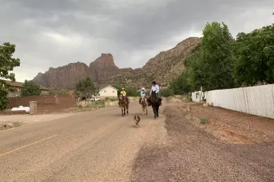
On the road, although the scenery is along the way, fatigue is inevitable. So the little elk doll my dad bought me at the Grand Canyon naturally became our car's mascot—a "cute" sight in front of the window.
Of course, a mascot can't just sit around. We had her hold things within easy reach, like snacks, fruit, and money...
In the end~ the mascot only held the money steadily ╮(╯▽╰)╭. Other things often went flying with a "biu"~
But looking at her, she's still so cute and makes us happy!
~18-Day American West Road Trip~
〖Route 66〗
〖Grand Canyon〗
〖American Highways〗
〖Monument Valley〗
〖Bryce Canyon National Park〗
〖Las Vegas〗
〖Yosemite〗
〖Palace of Fine Arts〗
〖Golden Gate Bridge in Fog〗
〖Highway 1〗
〖Universal Studios Hollywood〗
〖Santa Monica Beach〗
〖Joshua Tree National Park〗
I flew from Costa Rica to Los Angeles, and my dad flew from Shanghai to Los Angeles. Our flights were only two hours apart. We rented a car starting from Los Angeles, drove around, and finally returned to Los Angeles to go home.
1. Shanghai-Los Angeles Round-Trip Airfare
Off-season round-trip prices are incredibly cheap, fluctuating around 2k RMB. The three major US airlines—American Airlines, Delta Air Lines, and United Airlines—all offer similar prices. The only difference is the timing.
I chose United Airlines because it arrives in Los Angeles in the afternoon, close to my flight from Costa Rica, making it convenient to wait at the airport for my dad.
The return time was also comfortable: board in the morning, arrive in Shanghai around 11 PM, go straight to bed to adjust for jet lag.
2. Los Angeles-Shanghai One-Way Airfare
One-way tickets back to China are not as cheap as round trips. The average one-way price is between 3k and 3.5k RMB. Although connecting flights can be around 2k, it's unnecessary. I chose the same return flight as my dad for 3k RMB.
Nowadays, many people drive abroad for travel. Since we don't have international driver's licenses, we need a notarized translation of our Chinese driver's license for renting a car abroad. Then choose a car on the rental platform and pick it up locally.
First, I recommend essential driving documents: your Chinese driver's license, your passport, and the notarized translation certificate! Countries listed on this certificate recognize the translation, allowing you to drive freely. (Some US states do not recognize Chinese driver's licenses or translations, meaning you cannot drive within those states. Please note!)
This translation certificate can be applied for online in advance, very convenient—no need for complicated procedures. It's the white booklet shown below~
The US is truly a great place for road trips because many scenic spots and national parks lack public transportation, making driving the best way to explore.
However, for first-time US road trippers, it's essential to understand how driving works in America.
I. Renting and Returning a Car
Renting: I booked through Ctrip, which is essentially an agent that sends the order to the rental company. After arriving at Los Angeles Airport, take the shuttle bus from the rental company's stop at the entrance to their office (a bit far from the airport). Complete the rental procedures.
Pickup: I rented from Alamo. The staff didn't push insurance but tried to upsell a car upgrade. After I refused, they offered a "no need to refuel before return" option. This doesn't mean a free tank; it's just a reasonable fuel price, but there's an additional service fee. After calculating, I recommend refueling yourself! They checked my documents, swiped my credit card, and added an additional driver for free. You need to be 21 or older to rent (supposedly). If someone else will drive, both their driver's license and translation must be provided, and their credit card must be used as a guarantee.
After completing the paperwork, go to the corresponding area to pick a car based on your number. As others have said, the car is in the same class as the one you booked, but not necessarily the exact model. My first issue: I booked a Jeep Compass, but there was no Jeep available, and the other models were inferior (though I know nothing about cars, it was obvious). No staff helped; I had to choose a small SUV that suited me—a Nissan Rogue Sport. After returning the car, I confirmed with Ctrip and got a refund for the price difference.
After picking the car, inspect it yourself, then drive to the exit where a staff member signs off without even checking the car. US car pickup is very self-service!
Returning: The return area is next to the pickup lot. They check the fuel level and major scratches, then settle the bill at the office. It's quick.
II. Driving in the US
Let's talk about city traffic. The main cities I drove through were Los Angeles, San Francisco, and Las Vegas. US city planning is interesting: even in urban areas, main roads are highways or expressways. To reach a specific neighborhood, you exit the highway nearby. That's the regular street grid. This improves traffic efficiency and gets you anywhere faster.
Highways between developed areas are convenient and interconnected. In more rural areas, there are regular roads—slightly slower than highways but still convenient, with parking spaces along the side, making for a more comfortable drive.
Generally, you can just follow highway signs; they indicate which lane to take. Occasionally, you need to check a map. There's a special lane in the center for cars with 2 or more people to encourage carpooling and reduce congestion.
The hardest driving in the American West is in Yosemite—mountain roads along cliffs, narrow and winding with many curves, driven at high speeds—quite dangerous.
Many people told me before my trip that I'd be scared because US roads have so many fast cars. In reality, US roads do have many fast cars! But if you often drive on highways in China, driving in the US is no problem at all.
Speed limits on US roads range from 55 mph to 80 mph, with signs at different sections. Note: 1 mile = 1.6 km, so a 75 mph sign means about 120 km/h. On your speedometer, read the MPH scale!
Many people say US drivers speed a lot. Yes, if everyone is driving fast, it's best to go with the flow, but don't overtake or be the one leading.
Since expressways and highways have many lanes and high speeds, change lanes early if you need to exit.
Refueling in the US is mostly self-service. You can pay with cash or credit card—they take a deposit and refund the difference. I prefer cash.
① Park at an empty pump and check if the fuel type matches your car.
② Regular gasoline for most cars and SUVs is 87 octane. If a station in the mountains doesn't have 87, use 88 or 91. Ask the rental company to confirm.
③ Go to the counter and tell the cashier, "Pump #, regular, $xx."
④ Return to the pump, insert the nozzle into your car's fuel port, press the 87 button, and it starts pumping automatically. There's a small metal tab under the nozzle to hold it open, freeing your hands. It will stop automatically when full. But some old pumps have unstable nozzles—watch out! (I had a spill once.)
⑤ If the pump stops before reaching the amount you paid, go back to the counter for a refund. If it matches, drive off.
Pump style below↓
This must be mentioned early: There aren't many surveillance cameras in the US; traffic enforcement relies on police patrols. If you get pulled over—especially for speeding—apologize profusely, say you don't know the rules, don't make sudden movements (lest they think you have a gun), listen carefully to the officer, say you understand and will comply, and accept whatever outcome (ticket or not).
Tip: On popular roads, police often hide in parking areas or bushes. Even with my poor eyesight, I can see their flashing lights. Can you slow down? Show you're driving properly? Slowing down usually solves the problem. But safe driving is paramount!
5. Stop Signs
I'm highlighting this because it's important. In the US, stop signs have the same function as traffic lights. Learn them first for safety.
There are two types: "STOP" and "YIELD." You must stop at both. Some intersections have four-way stops; the first car to stop goes first. If no cars, stop for 3 seconds then go. Eventually, these signs become a courtesy—everyone seems to coordinate and take turns.
Parking is a headache everywhere, including in the US, especially in city centers and suburbs. Major attractions have designated parking, and motels usually have plenty of spaces.
City: Some curbside parking has various restrictions—15-minute limit, 60-minute limit, Monday-Friday only, evenings only, etc. Read signs carefully. Alternatively, use parking lots. I recommend the app Best Parking to search for lots, even showing prices.
Suburbs: Regular roads often have designated parking areas, especially scenic spots like the iconic Monument Valley three-mitt view, but spaces are limited and may be full in peak season. Highway emergency lanes are for temporary stops only—don't park long. If tired or wanting photos, exit to a service area; US service areas are well-developed.
Traffic lights in the US don't blink green; they go directly from green to yellow to red. The yellow light lasts longer. If approaching an intersection at speed and the light turns yellow, don't slam on the brakes if you can safely cross before red. But if you see the yellow from a distance, don't accelerate—brake and stop. Better to wait a minute than get a ticket.
There are toll highways and bridges in the US. I didn't encounter any toll highways, so I can't explain.
But every bridge in San Francisco charges a toll. The Bay Bridge costs $6 one way, paid at the entrance—look for cash lanes. The Golden Gate Bridge is one-way: free from south to north, toll from north to south. The toll is collected electronically; you can pay yourself or use the rental company's automatic system (which adds a surcharge, roughly doubling the cost).
Golden Gate Bridge payment website: ;
Payment: Buy a single pass in advance or pay within 48 hours.
Big bug: I bought a pass and it said successful, but because the rental company's auto-pay was active, they charged me their fee instead of using my pass. So I had to pay the expensive rental company fee—unreasonable!
9. Weather Effects
US weather is highly variable, and within a few hours you can encounter complex conditions. Here's how weather affects driving:
① Sun: Especially setting sun; without China's haze to diffuse light, it's blinding. One day, driving directly west, my eyes hurt—dangerous on the highway. Bring good sunglasses! Essential!
② Heavy Rain: During the day, you can manage. At night on the highway, heavy rain makes visibility nearly zero—drive slowly!
③ Strong Winds: The American West landscape resembles Xinjiang, with strong valley winds and crosswinds. Rent a heavier car—an SUV is better.
④ Ice and Snow: In March, many places in the American West still have heavy snow. Bryce and the Grand Canyon had icy roads. Avoid driving on edges where ice is thick. Follow tire tracks if possible. If snow completely covers the road (like in Bryce), drive slowly and stay in the middle. In Yosemite, use snow chains if snowing—cliffside roads require caution. Keep a firm grip on the steering wheel; don't panic!
If snow covers the car overnight, clear it in the morning and turn on the heater early to prevent snow from falling off and causing wheel spin.
⑤ Sand and Gravel: In desert areas, stick to main roads. Avoid gravel roads—if you get stuck, it's a big problem. In places like Monument Valley, avoid back roads; they're muddy and potholed.
⑥ Night: Driving at night on highways is exhausting—fast speeds, many cars, poor visibility. Headlights impair distance judgment.
There are many rural roads in the American West. I didn't encounter wildlife, but something annoying: on several highways, there were lots of butterflies and insects. Even in daylight, they splatter yellow goo on the windshield that wipers can't clean. The front of the car gets covered in bug remains—drives OCD people crazy.
In the US, you must yield to pedestrians, even if they jaywalk. Also, watch for school buses—you must stop. I've heard you must stop even when approaching from the opposite direction because children might cross the road. Not stopping results in a ticket or a report from the bus driver.
12. Bugs
US roads were built many years ago, and their designs can be confusing.
For example, the rightmost lane at an exit often splits Y-shaped, allowing you to go left or right. But occasionally, the right lane suddenly becomes an exit only, forcing you to merge left, crossing solid lines—especially tricky at night.
Another example: Highway signs point to two lanes leading to Highway 101, but up ahead, the left lane might go to 101 while the right goes to another highway. The passenger must help navigate!
If you make a wrong turn, don't panic. Recalculate your route. US highways have many exits, so you can detour via local roads to get back on the highway.
Common safety issues like speeding, not cutting off other cars, and avoiding debris are obvious—I won't elaborate.
What I found most dangerous in the US is... car break-ins!
According to a WeChat group for self-drive travelers, 8 cars were broken into in one week. The thieves were experienced and targeted tourists. Some only stole a bag (just for a charging cable), others stole entire suitcases. Shocking!
So, here are tips to prevent break-ins:
① Take all visible bags with you when you leave the car. If it's a small car, lock valuables in the trunk.
② If possible, leave luggage at the hotel.
③ SUV trunks aren't secure. Don't bring luggage, and pull the trunk cover down to show nothing valuable is visible.
④ Parking lots at San Francisco attractions are hotspots; also common in Los Angeles and outlets. Be prepared!
If your car is broken into, stay calm. Check what's stolen, call the police, get a report, contact the rental company to exchange the car, and file an insurance claim.
III. Driving Route
I've already listed the itinerary earlier, so I won't repeat it. Here's a map of the route I drove in the American West—a novice female driver's first long journey.
I've explained a lot about how to drive. For national park road conditions, search online before your trip—conditions vary by season. I wish you a smooth road trip in the American West!
As a novice female driver:
Since getting my license, I've rarely driven (no car at home). Occasionally, I drive during trips, so I've driven more highways than city streets. I got used to the fast US highways quickly; I wasn't nervous, only worried about speeding.
Over the entire trip, the biggest challenge (besides snow and ice) was the exhaustion of driving alone. After three consecutive days, the initial excitement turned into numbness. For long road trips, it's better to have someone to share the driving.
This was my first 5,600 km as a novice driver. After this, I can consider myself experienced. But back home, I won't touch the steering wheel again until my next 5,000 km trip.
When booking US accommodation, many recommended Airbnb for good value. But perhaps because I booked late or we were only two, Airbnb wasn't cheap, didn't offer private space, and had inconvenient parking. Hotels ranged from $100 to $200 per night, affordable except in national parks and big cities.
Typical motels offer convenient parking, comfortable rooms, and free breakfast.
Los Angeles is large and divided into areas. On arrival, I stayed near Monterey Park (Chinese community) in a standalone villa—quiet, but several guest units shared the building. The host was Chinese, so communication was easy. The next day, I took Route 66 out of town.
Travelodge by Wyndham Williams Grand Canyon
Williams is the best stop before the Grand Canyon's South Rim and a major town on Route 66. Affordable motel with a public hot spring; rooms were warm and draft-free.
Grand Canyon Plaza Hotel Tusayan
Tusayan, 5 minutes from the South Rim, but prices reflect the proximity. However, it was cozy and hotel-grade. For four people, it's the best value—all in one room.
IV. Monument Valley
The View Hotel
The only hotel inside Monument Valley, with excellent views and ethnic style. Off-season prices are reasonable; book at least a month in advance even in off-season!
Booking link: ;
Payment is a bit complicated: you can use any card to hold the reservation, then the hotel emails you about a week before check-in to provide another card for payment. Monitor your email, or the reservation may be canceled! After payment, you receive a new confirmation.
Best Western Plus Ruby's Inn
Affordable hotel, but large—you need to drive to your room. The standard for a motel. Bryce was very cold, and the room was drafty.
Clarion Inn & Suites
We stopped here after Bryce, thinking it was late. Surrounded by snowy mountains, it was colder than elsewhere. Motel standard, but near Walmart, so shopping and eating were convenient. Easy to leave town next day.
VII. Las Vegas
MGM Grand Hotel & Las Vegas
Las Vegas, a city of luxury, has palatial hotels. We were there on a weekend, so we chose MGM within budget. Tip: pay extra for the main building—these hotels are huge, and distance matters. MGM is centrally located, close to The Venetian and Caesars, but parking is difficult. The hotel charges resort fees and parking fees, making it overall expensive.
VIII. Fresno
Best Western Village Inn
Closest city to Yosemite's South Entrance. Motel, near highway entrance, in a safe area with a lively commercial district. Cozy and comfortable. Relatively pricey.
Buena Vista Motor Inn
Chosen for two reasons: downtown location and free parking. San Francisco has many car break-ins, so parking at the hotel and not driving is safest. The room was huge and comfortable, though a bit old.
King Frederik Inn
A fairytale town on Highway 1, worth staying in. Motel with full facilities; park right outside the room—very convenient.
XI. Burbank
Holiday Inn Burbank Media Center
Burbank is a media hub near Los Angeles. Staying here means proximity to Hollywood attractions and high safety. Prices in this area are generally high—even motels are around 1000 RMB—so Holiday Inn offers good value, and parking isn't too expensive.
XII. Palm Springs
Fairfield Inn & Suites by Marriott Palm Desert
Palm Springs is an oasis in the desert, popular with American vacationers. Trendy hotels and high-end resorts abound, plus quirky desert RVs, driving prices up—approaching Los Angeles levels. We chose this affordable hotel near the highway with good breakfast. It's less than 20 minutes from Joshua Tree's South Entrance.
XIII. Los Angeles
Hilton Los Angeles Airport
Our last day in LA, we stayed near the airport for an early morning flight. Free airport shuttle and easy car return. Hilton was reasonably priced and comfortable.
US visas are now valid for 10 years, requiring an in-person interview at the consulate. Success rates vary by year and consulate. I heard that if they collect your passport on the spot, it's not final; you'll be notified within days whether the visa is granted. It's somewhat challenging.
Visa process: Fill out application online → schedule interview → pay fee → interview → collect visa.
Documents: Bring everything that proves you won't overstay—the more, the better! (You'll need to fill in all this information in the application form; ensure it's accurate.) A reasonable itinerary is also important.
Using a visa agency: They charge a fee for filling out forms, scheduling, and payment, but you still have to prepare documents and attend the interview.
EVUS: You need to update it yourself. Update before traveling to the US. Newly issued visas also require updating. In short, register before you go: https://www.evus.gov/evus/#/
Although the American West doesn't seem too vast, its terrain varies greatly, making the climate highly changeable. In just 18 days, we experienced everything from hot summer to icy winter. But these weather conditions were only for March.
Los Angeles, Highway 1, San Francisco: Along the coast, daytime temperatures with sun aren't too low, but cloudy, rainy, and nighttime are cold. Bring warm clothes.
Yosemite: Higher elevation with remaining snow, not freezing cold; you can wear sweaters or light jackets.
Death Valley, Joshua Tree: Arid landscapes; extremely hot under the sun, but very windy.
Grand Canyon: Pleasant temperature in the sun, but windy. In March, it can snow at night—quite cold, so dress warmly.
Monument Valley: We encountered strong winds and rain; the famous three mitts were invisible. It rained for about 2 days, very cold at night.
Bryce Canyon: The coldest spot of the trip. Snow covered the roads; we were so cold we didn't want to leave the room. All hiking trails were closed in March.
-14 hours: Monument Valley & Utah
-15 hours: Los Angeles, San Francisco
Note: Driving in the American West, there's a time difference! Besides daylight saving and standard time, even a one-hour difference can cause confusion. Monument Valley follows Utah time (GMT-7 in winter, -6 in summer), but Page (Arizona) is GMT-7 year-round. When visiting Antelope Canyon, confirm the local time—your phone might incorrectly switch to Utah time.
English is commonly used in the US. Basic English will get you through easily.
Nowadays, we can't live without the internet. Here are some options:
1. Local SIM cards
Pros: Various plans, relatively cheap, some with call minutes.
Cons: Language barriers for activation and use; data caps; need to switch SIM.
2. Portable WiFi (like Roaming Man)
Pros: Available in many countries; connects immediately upon arrival; can be shared by multiple people; plenty of data.
Cons: Extra device; needs a power bank.
Recommendation: Use a portable WiFi device—most convenient. You can keep your home number running with international roaming for calls (since you don't call much), so a local SIM is less useful.
The biggest issue in the US is car break-ins targeting tourists, especially in parking lots at San Francisco and Los Angeles attractions. Thieves work fast, targeting visible bags on seats, and even SUVs with locked trunks—they might break in just for a charging cable. Incidents have occurred at Golden Gate Bridge viewpoint, Lombard Street, outlets, etc. For advice on what to do after a break-in, search online.
Before going abroad, buy travel insurance. It covers various issues: transportation, driving, dining, outdoor activities, and local safety.
Since I travel abroad often, I bought an annual global policy from Allianz, which also covers the Schengen area.
Cuba does not recognize US-issued insurance, but Allianz (German) works.
Allianz has basic and comprehensive plans; the comprehensive one covers driving, traffic accidents, and all outdoor activities—peace of mind for travel.
Link: ;
【Useful Apps】
1. Uber
Download Uber, register, and bind a credit card. When you arrive at your destination, the fare is automatically deducted.
Uber works like Didi in China. Enter pickup and drop-off, and it shows an estimated fare based on weather and traffic (usually close unless there's a detour).
Recommend paying by credit card because I've encountered drivers who deliberately take detours to increase the fare when cash is selected. With credit card, you can dispute. Also, it avoids unreasonably high taxi fares.
2. Translation App
Google Translate is recommended. Even with basic English, if you encounter communication problems, a translation app is more reliable.
3. Google Maps
Works in most places. You can mark attractions, view info and official websites, and read user reviews.
4. Travel Websites
Apps for booking flights, hotels, B&Bs, etc. Compare prices and keep records of orders.
5. Social Apps
Facebook or WhatsApp. When you can't use phone calls or WeChat abroad, these are convenient for communicating with foreigners and even making calls.
6. Best Parking
Parking is a headache for drivers. In US cities, use Best Parking to check parking lot locations and prices near your destination.
You'd be surprised—neighboring lots can cost $2/hour vs. $30/hour. Avoid being ripped off by checking first.
【Route 66】
Route 66, known as America's "Mother Road," runs across the US. In recent years, many people pay homage to it. Especially by driving along it. The most interesting part is that each small town has its own character, great for photos. Here are recommendations from west to east, from Los Angeles to Williams.
Many people don't know about the Glass Forest in Helendale. Along this historic Route 66, this art gallery astonishes visitors. Among the glass trees, there are also old objects that evoke memories.
A famous small town on Route 66, most importantly home to the Route 66 Museum. But compared to the museum, the trendy fast-food restaurant here is the most popular photo spot.
An unintentionally discovered town that is the inspiration for the movie "Cars." Although it's just a small town along Route 66, it's interesting. From this town toward Williams, you can drive a section of Route 66 with ups and downs accompanied by funny roadside signs—a different experience.
【Grand Canyon National Park】
Grand Canyon National Park, also called the Grand Canyon, was carved by the Colorado River over millions of years. It's a must-see attraction in the US and a World Heritage site. The canyon is huge, with many ways to explore. In winter, only the South Rim is open; the North and West Rims open in summer. I'll only cover the basic South Rim route.
Entrance Fee: America the Beautiful Pass $80/car
The South Rim is divided into three sections: the western Hermit Road (red), the eastern Desert View Drive (orange), and the central area with the visitor center and in-park lodging (blue). The colors correspond to free shuttle bus routes.
Generally, you need two days: one day for the two viewpoints near the visitor center + Hermit Road (half a day due to infrequent shuttles), and another day for the East Rim.
Classic Route: Viewpoints around the Visitor Center
Park at the visitor center and walk to two viewpoints: Mather Point → Yavapai Point → take the orange shuttle back. These are classic spots for panoramic views of the Grand Canyon.
Yaki Point is a classic sunrise spot, accessible only by shuttle.
Hermit Road: 9 viewpoints for spectacular views of the canyon and Colorado River.
Private cars are not allowed on Hermit Road; you must take the red shuttle. Shuttles run infrequently and may be full, so allow at least 2 hours. You can choose a few viewpoints, but most have no railings—be careful.
The blue shuttle in the park also runs infrequently. If taking the red shuttle, consider parking near the Hermit Road shuttle stop.
Hopi Point is a classic sunset viewpoint.
Desert View: A long drive to the East Entrance; only accessible by car.
The main viewpoint is the Watchtower at the easternmost point. Beautiful scenery, but no shuttle service. If entering or exiting via the East Entrance, it's worth a stop. If short on time, skip.
We encountered heavy snow; the misty Desert View was truly beautiful.
【Monument Valley】
The "three mitts" and US Highway 163
Monument Valley became famous because of the running scene in "Forrest Gump," with the iconic three mitts and Highway 163 in the background. This scene is not inside the park but on the highway outside. Drive from the Grand Canyon toward Monument Valley, continuing past the park entrance to the road with the three mitts.
Coordinates: 37.102750, -109.989056
Photo spots: There are several parking areas on both sides—choose your favorite.
Best time: Sunrise, when the light is behind you, making the mitts look great.
The View Hotel
The only hotel inside Monument Valley. You can open the balcony door and see the beautiful valley—a panoramic room. The hotel is designed in the local Navajo style and has its own viewing deck where you can enjoy coffee and the view. We had bad weather, so we stayed in the room enjoying the view.
Booking link: ;
Rates: Off-season from $99, peak season from $219 (plus tax); book off-season a month in advance, peak season three months in advance.
Exploring Monument Valley
The internal roads are rough; you can drive in but may get lost. Ask the front desk for a map. If you're not confident driving, join a Navajo-guided tour.
Entrance Fee: $20/car
Whether or not you stay in Monument Valley, you need to buy a ticket.
Antelope Canyon, divided into Upper and Lower, was formed by flash floods scouring soft sandstone. It's a photographer's paradise, famous for its beautiful canyon patterns with light creating perfect lines. Because rain can cause flooding, it's always dangerous, and you must be accompanied by a guide. There are photography tours and regular tours. In winter, also recommend Lower Antelope Canyon because Upper may lack light. Midday is the most popular time; book in advance and bring sand protection—sand in the eyes is painful.
Two companies operate Lower Antelope Canyon. I chose Ken's Tour; I think it was the right choice—their waiting hall is much better than the other!
Booking link: https://lowerantelope.com/
Photography tours require a tripod, last one hour, and the area is cleared. Regular tours forbid tripods, are rushed, and last half an hour. If you have photography needs, choose the photography tour.
Horseshoe Bend is a U-shaped meander of the Colorado River in Arizona, part of Glen Canyon. Named for its shape, it's just outside Page. No entrance fee, but when I went, there was a shuttle situation. Private cars couldn't park at Horseshoe Bend; we had to park in a lot in Page and take a shuttle for $5 per person—a bit of a scam. Some people said they didn't encounter this, so I'm not sure.
If you do encounter a shuttle, allow at least 2 hours because the wait can be 20 minutes or more, and you might not get on the first bus.
【Bryce Canyon National Park】
Bryce Canyon National Park in southwestern Utah is famous for its unique geological structures called hoodoos. Why visit? Because under a blanket of snow, Bryce looks adorable—like finger biscuits dipped in sugar. Such scenery is rare. After visiting, I had no regrets.
Entrance Fee: America the Beautiful Pass $80/car.
One great thing about Bryce: the sunrise and sunset viewpoints are clearly named and easy to find. The best view is from Inspiration Point, which has a large open area without railings (a bit dangerous) and a hiking trail. In winter, the trail is icy—better to avoid.
If possible, watch the sunset at Bryce—it's beautiful, especially with snow.
Besides viewpoints, there are hiking trails inside the canyon, offering a sense of how small humans are among the hoodoos. Trails take 3-5 hours; ask at the visitor center for recommendations. Note: In winter or early spring, trails may be closed due to snow. We encountered that!
【Las Vegas】
Las Vegas needs no introduction—the world-famous gambling city. Once you're here, money seems to slip away. I originally planned only to experience a luxury hotel, but I ended up shopping nonstop!
There are countless ways to enjoy Vegas. Must-dos include the "Welcome to Fabulous Las Vegas" sign (right out of the airport), visits to luxury hotels, fountain and volcano shows. Optional: buffet dinners, magic shows at night... A hundred people have a hundred ways. No specific recommendation.
Death Valley, true to its name, due to its extreme geography, elevation, and low rainfall, creates a Mars-like environment. The main road through Death Valley is a regular US highway, so there are no entry checkpoints. Here you'll find not only danxia landforms but also salt flats, deserts, all against a backdrop of towering snowy mountains.
The basic route through Death Valley is W-shaped (main road), with some side roads. Check road conditions and openings before deciding. Main points 1, 2, 3, 4 are on the main road; others require more time.
Entrance Fee: America the Beautiful Pass $80/car.
1. Badwater Basin
Lower than sea level; very sunny. Quick look at the salt flats; not recommended to go deep.
2. Artist's Drive
This is the real fun part. I thought it would be about colorful danxia—less impressive than Zhangye's. But the highlight here is the excitement: natural winding roads that feel like driving a go-kart. Many vehicles come here, but be careful—safety first!
3. Zabriskie Point
The terrain looks like folds in the earth's skin. Official sunrise/sunset viewpoint.
4. Mesquite Flat Sand Dunes
Large dunes in a valley. If you haven't experienced desert, go in. (We're from China where we've seen plenty, so we skipped.)
5. Badwater Basin Vista Point
Near the east entrance, a side road leads to this viewpoint overlooking the entire basin.
6. Ghost Town (Skidoo or similar)
Remnants of a gold mining operation.
7. Ubehebe Crater
A huge volcanic crater, believed to be about 800 years old.
8. Charcoal Kilns
Wild Rose Charcoal Kilns—ten beehive-shaped structures, the best preserved, built in 1877 to produce fuel for processing silver/lead ore.
9. Father Crowley Vista Point
Colorful landscape canyon; possible to see military exercises.
【Yosemite National Park】
Yosemite has become very popular among Chinese tourists recently. My first impression: like a big scene from a video game—a waterfall under a giant cliff, surrounded by dense forests. The drive into Yosemite is even more exciting than the scenery—thrilling mountain roads make the experience intense. Yosemite isn't just one area; it's a vast national forest.
There are three entrances: East, South, West. The East Entrance is at high elevation with winding roads, closed in winter due to snow. The other two are open year-round. Before visiting, check if snow chains are required; fines for not having them can be huge.
In reality, we only visited a small part of the park—the Yosemite Valley area (about 1 mile wide, 7 miles long). There are two must-see cliff waterfalls and many classic hiking trails, making it a favorite for American hikers.
Entrance Fee: America the Beautiful Pass $80/car.
Tunnel View
A panoramic viewpoint offering the best overall view of Yosemite.
Bridalveil Fall
The waterfall visible from Tunnel View, cascading beautifully through the rocks.
Yosemite Falls
The tallest waterfall in North America, the most spectacular in Yosemite.
Valley View
A less conspicuous viewpoint in the valley, easy to miss, but here you can see the reflection of the entire valley.
【Palace of Fine Arts】
This might be my favorite spot in San Francisco. The Palace was built for the 1915 Panama-Pacific Exposition and later redesigned by renowned German architect Bernard Maybeck. It's now a Roman-style art palace.
【Golden Gate Bridge】
The most famous bridge in the US, an engineering marvel, and a must-see in San Francisco. "Fog-covered Golden Gate" is a famous beauty. There are many viewing angles: two viewpoints on one shore, plus hidden spots like from a boat or the beach.
【Highway 1】
California State Route 1, known as the most beautiful coastal highway in the US, with cliffside ocean views, making it a must-drive route. The typical time to enjoy Highway 1 is 2-3 days, with coastal scenery plus photo-worthy spots and charming towns.
Pigeon Point
One of the oldest and most famous lighthouses on Highway 1. A paradise for photographers and a great spot for whale watching.
17-Mile Drive
A private coastal area near Carmel, turned into a scenic drive. Besides rocky shores, the forest trails are amazing—worth a visit. If possible, stay in Carmel; it's a fairy-tale town with each house having its own uniquely designed garden.
Bixby Creek Bridge
A bridge on a cliffside, iconic due to Highway 1's ruggedness and frequent closures in rain—a popular photo stop.
Solvang
A charming Danish-style town. Entering at night felt like a fairy tale, with storybook houses everywhere.
Santa Barbara
A city of white buildings, Spanish-style, popular with wealthy Americans.
【Universal Studios Hollywood】
One of America's classic theme parks, a must-visit in Los Angeles. I loved Universal Studios Japan, where movies are turned into rides—a great park for film fans. Hollywood's version is older and includes a backlot tour of Hollywood. The park is relatively small with few rides, but crowded!
Ticket: 615 RMB (booked on a Chinese travel site, cheaper than official site).
Parking: $25, $35, $50 for different distances.
【Santa Monica Beach】
The most famous beach in the sunny city of Los Angeles, also the terminus of Route 66. Even in March, many Americans swim in the ocean—impressive in the cold. There's a pier with an amusement park and a Route 66 monument.
【Joshua Tree National Park】
Joshua tree is a type of plant, abundant here, giving the park its name. The trees are cute, combined with rocks and gravel, full of rustic charm. Many Americans consider it an outdoor paradise, climbing among the boulders. Watch out for rattlesnakes, scorpions, and spiky cacti.
Entrance Fee: America the Beautiful Pass $80/car.
Recommend driving one-way: enter at the North Entrance, exit at the South Entrance, or vice versa. Most enter from the north. After 11 AM, the northern sights get crowded.
Because Joshua Tree spans two desert ecosystems, the landscapes and activities differ.
The northern area: Concentrated Joshua trees, best for photos with them. Many rocky hills for climbing. Suitable for camping, hiking, exploring, rock climbing. Check the North Visitor Center for fee-based activities.
The southern area: Lower elevation, scenic drive with cholla cactus garden—unique small cacti native to this park.
Salvation Mountain
In recent years, it's become a popular Instagram spot in the American West. Built by Leonard Knight over 30 years, a colorful mountain in the desert as a tribute to "God is Love."
【Outlets】
Usually, people shop at the end of their trip. Since our last stop was Los Angeles, I recommend nearby outlets. We visited two: Camarillo Outlets and Desert Hills Premium Outlets. Here are pros and cons:
Camarillo Outlets
Pros: Very close to Los Angeles, on the way from Highway 1. Large area divided into three sections; you can drive from store to store. When not crowded, you can park right at the store. Good brand selection, especially for women's favorites like AE and Kate Spade—plenty of styles without crowds.
Cons: I have no complaints. Maybe fewer big brands than Desert Hills, and perhaps fewer discounts, but it didn't affect my shopping.
Desert Hills Premium Outlets
Pros: Large, also three sections, many brands from international high-end to everyday. But each store is small. Many Chinese tourists, so you can get extra discounts—check on-site.
Cons: Parking is on the perimeter; you have to walk everywhere. Too crowded; long lines to try on or pay—poor experience. Small stores with limited selection. Far from Los Angeles, long drive.
【America the Beautiful Pass】
This is an annual pass for all national parks administered by the National Park Service, covering 62 parks including Yellowstone, Grand Canyon, Yosemite, etc.
Entry is per vehicle: a vehicle with 1-4 people costs $25-$30 per park (that I've seen). The pass costs $80 and is valid for one year. You can write two names on it; the pass and passport grant entry to any national park.
If your trip includes 4 or more national parks, buy the pass—it's excellent value!
Website: https://www.nps.gov/subjects/uspp/index.htm
I recommend that travelers visiting US national parks go to the official website for each park (each has its own) to check current conditions and road updates.
Expenses: This trip was for my dad and me together, including all costs.
Arrival in Los Angeles: A Long-Awaited Reunion
More than two months had passed. Waiting at the airport arrivals hall for my dad, I was a bit excited. On one hand, a long road trip was about to start and I was the sole driver; on the other, I really hadn't seen my dad in a long time. Recalling our last long trip: after 2.5 months apart, he looked thinner. Would he be thinner this time? What expression would he have?
I was worried about him getting stuck at customs—US customs is notorious. I prepared a printed itinerary and hotel list in English to avoid trouble, but I was still anxious. I repeatedly told him to not speak if he didn't understand English, and find someone who could translate.
After a long wait, I spotted him in the crowd. We smiled at each other.
"How long did customs ask you?"
"They didn't ask anything, just stamped."
"What? No questions about the itinerary or hotel?"
"None. People on the same flight were held up for questioning, but I passed quickly."
"Amazing~"
Later we thought maybe it was because our visas were issued early; new visa holders might face more scrutiny.
We took the shuttle to the rental car office. US car rental is fast: after a series of sales offers, we signed and went to pick up the car.
Car pickup is very lax: no one helps you choose; you're directed to the same class and left to pick. I don't know cars. The Jeep I booked wasn't available; the best option was a Nissan SUV. I consulted an external expert and chose the Nissan Rogue Sport for suitability and overall value. For two people, the space was good—our 28", 24", and 20" suitcases fit easily.
Nobody checked the car; we just signed at the exit and drove off.
We stayed in a Chinese community in Los Angeles. After driving on busy, fast city highways, I quickly learned the ropes—not as stressful as online said.
The Chinese supermarket in the community was great: affordable and well-stocked. We bought a carload of snacks for the road, including ingredients for dinner at the B&B.
But the B&B disappointed me on the first night—not because it wasn't comfortable, but because it wasn't private. Typically, US B&Bs either share space with the host or with other guests. I didn't like that interference, so I never considered B&Bs again.
Los Angeles nights are chilly. After quickly organizing our luggage, we rested well, ready to start the American West road trip.
Route 66: A Road Dream for Everyone
When mentioning the US, many people might first think of Route 66, not a national park. Route 66 is not just America's "Mother Road" but also a pilgrimage route for everyone visiting the American West.
Route 66 diagonally crosses the US, from Chicago to Santa Monica Beach in Los Angeles. Since its completion, it has been an economic lifeline, and commerce flourished along it. Its length gave many towns unique characteristics, making them landmarks along the route.
Eventually, when the Interstate Highway System was built, Route 66 faded from history. But this road, recording decades of American development, is forever remembered. Many American movies were filmed here, and driving Route 66 has become a bucket-list item for many dreamers of the American West.
My dad wasn't very familiar with Route 66, and we only had one day, so I chose a few interesting spots to check off, while also driving a stretch of the old road.
A Forgotten Town
From Los Angeles, we quickly drove into the mountains. The view opened up; there were many RVs on the highway heading out of town—lively.
Our goal was to get on the old Route 66 and feel its history. We exited at Victorville onto an old road, squeezing with trucks on this dirt track. Today, the old Route 66 serves different purposes in different areas; here, it was used for construction and transport.
As we entered the old road, dust flew—or maybe the gloomy sky made it feel dustier. Soon, we saw a seemingly abandoned but once lively town with an old, unused train yard. Occasionally, freight trains slowly passed in the distance.
Even this abandoned town had Route 66 signs everywhere; we were on the right track.
This small town already exuded the unique charm of Route 66. It originally served as a rest area for road-weary drivers, full of Old West flavor.
Though the town was abandoned, a historic Route 66 map was still painted on a wall, now called Historic Route 66.
The town's decorations were interesting, reflecting American creativity and little joys.
This Is a Glass Forest!
The abandoned town wasn't our main target. After a few photos, we hurried to our first destination—an art paradise on this stretch of old Route 66.
The Glass Forest in Helendale was created by an American grandfather named Elmer Long, a dream made real.
Driving along Route 66, you soon see this small forest, but it's fenced off, so you can't fully appreciate it at first. Yet, on this barren desert, such an art space is impressive.
This Glass Forest wasn't built in a day. Elmer Long collected glass bottles from the desert over many years and created this place 20 years ago. The habit of collecting glass bottles came from his father, and the forest became a way to remember him.
The forest is dense with glass "trees": steel poles with thinner branches, hung with colorful glass bottles.
Looking closely, each tree is slightly different.
Of course, the forest isn't just glass; deeper inside, objects with American historical significance are placed among the trees, some already antiques.
Behind the forest is a metal-style house, with collected items stacked in the yard, exuding a retro vibe, bearing the marks of time.
Glass bottles glitter in the light, each with a story. Walking through feels like traveling through time.
There are many antiques that are hard to find elsewhere. Now they are specially placed in this forest, settling with time.
The Glass Forest is a dream of art and life created by the grandfather, inviting every traveler on Route 66 to find a story in a bottle. What story did you find?
Route 66 Landmark
Every tourist visits the Route 66 landmark. There are many signs—not too many, not too few, roughly every 20-30 minutes—but finding a clear one can be tricky.
Before leaving the old Route 66, we finally found a landmark to photograph. Such signs are usually only on the old route or in towns along it.
Kingman: Time for a Roadside Meal~
Leaving the old Route 66, we soon got on the highway. A long section of Route 66 overlaps with modern highways. The drive from Helendale to Kingman took over 4 hours; we arrived after 2 PM (maybe because I drove slowly). The windshield got splattered with "yellow bombs"—I thought it was bird droppings, but realized they were yellow butterflies or moths, crushed by speed.
Dust, mines, desolation—first impressions of Kingman. Exiting the highway, we quickly entered this town known as the "Heart of Route 66." The Route 66 Museum is here.
But my main purpose was to check out this girly fast-food restaurant. I didn't expect to find such a charming spot in the American West's rugged environment.
Most Route 66 towns exist for travelers; they serve fast food, no fancy meals. Compared to the dreary surroundings, this cute restaurant boosted our appetite.
Macaron pink and Tiffany blue—even from outside, it's a photo-worthy hotspot.
The interior is retro, with consistent color tones and many vintage decorations: movies, cars, American cartoons, etc.
Despite being past lunch time, the place was packed. We waited a bit for a seat.
If you don't mind other diners' looks, you'll find many items reminiscent of our 1990s childhood—same world, same childhood memories.
This was our first official meal in the US. Not knowing portion sizes, we each ordered a dish. They brought bread before the meal, and the jam—like freshly from the orchard—was delicious.
We didn't order the signature dishes because I'm not a fan of Western fare; a full burger platter would be too much. So I chose an omelet and a hot dog, with hash browns and fries. The taste was great—much better than expected for a trendy spot with only looks. We ate very well. Two full portions were a bit much, but after a long drive, we deserved a treat.
Between bites, I took a photo outside with the dreamy color contrast, holding my beloved Coke.
The small car behind the restaurant—probably for staff or food delivery—was super cute!
If you're a true Route 66 enthusiast, every detail—even a brick—carries history.
Across the street is the Route 66 Museum, documenting the road's history. But it's large, and we still had another stop on Route 66, so we left without visiting.
Seligman from "Cars"
Seligman is a small town not right off the highway. Exiting, I doubted we were on the right track amidst the barren surroundings. Needing gas, we asked directions—yes, keep driving into the desolation. The wind picked up, turning bitterly cold.
Seligman isn't far, but the low houses are hard to spot in the gloomy weather. This town was larger than the morning's ghost town, with more to explore, but very quiet.
The town's walls are covered with murals depicting classic Route 66 scenes.
Seligman's biggest draw: the entire town is the inspiration for "Cars." It feels like stepping into a cartoon world.
Wandering around, I accidentally entered someone's yard with many cars with eyes—weren't these characters from "Cars"? They looked quite lively.
Every shop on the street had cartoon elements.
Maybe because it was cold, many shops were open but with doors closed. You could take photos without disturbing anyone—immersing yourself in "Cars" was endless fun!
Various car characters lined both sides—a car heaven. I wanted to strike a Western cowboy pose.
Everything related to Route 66 becomes cartoon charm here—colorful, cute, making history light and fun. That's Seligman's charm.
Saying Goodbye to Route 66 in Williams
Leaving Seligman, our day's itinerary was nearly done. The sky wasn't too dark, so we took the old Route 66. The road wound through the desert, with the highway beside it. This small old road had fun curves—up, down, left, right. If I weren't visiting national parks, I'd spend more time on it.
Soon, we entered forested area and arrived in Williams. Williams was our stop for the night. A small town at the foot of the mountains, lively, and the gateway to the Grand Canyon's South Rim.
Probably due to elevation, it was very cold at night. After driving nearly 8 hours, I was exhausted but still wanted a hot meal.
We chose a popular Williams restaurant, Red Raven. We waited nearly half an hour for a seat. Wanting to avoid waste, my dad and I ordered one steak with sides of mashed potatoes and asparagus. I also got a hot chocolate. The portions were huge; we couldn't finish. However, the waiter's attitude was annoying—perhaps because we only ordered one meal, they pressured us to order more. That felt forced, especially since we paid an 18% mandatory tip. It's our choice what to eat. That was the only place with bad service, though the food was good.
Williams, the last stop on Route 66. That night, it was cold.
Grand Canyon National Park: Seeing All Four Seasons
Grand Canyon National Park, officially the Grand Canyon, carved by the Colorado River. A must-see, a World Heritage site. But it's huge, stretching 443 km east-west. Visitors only see a part; no one sees the whole thing.
The canyon is cut by the river, with North Rim, South Rim, and West Rim viewing areas. Due to weather, only the South Rim is open year-round, and it's the first choice for first-time visitors.
In March, we truly experienced all four seasons of the Grand Canyon in one day!
First Sight of the Grand Canyon: Classic Views
Waking up to a white world—snow had accumulated overnight. Being from a southern city, I rarely see snow.
Excitedly, I ran downstairs, loaded the car, and cleared the snow off. Though inexperienced, I knew I must remove all snow for safety. I quickly made a blueberry waffle from the breakfast bar and placed it on the dashboard. Let's go!
Before leaving Williams, I took one last look—a snowy town under the forest. No time to explore, though. We drove north on a road that leads straight to the South Rim viewpoints. It was an easy 1-hour+ drive.
We bought an America the Beautiful Pass, valid for one car. I registered my name; present passport and card for entry. At $80, it's great value!
We parked at the visitor center, already crowded. Nearby are two classic viewpoints: Mather Point and Yavapai Point.
Mather Point was busy, with a dedicated viewing platform. Many visitors brought dogs—lively. After the snow, we were blessed with a clear day. The canyon looked layered in sunlight.
Eroded by nature and time, the canyon's geology differs from top to bottom, with varying colors.
Sunlight played on the irregular rock faces, revealing water erosion marks. How many years to create this wonder? Red and gray layers indicate different rock compositions.
From Mather Point, we walked along the rim trail to Yavapai Point. The national park's ecology is pristine; we spotted deer lounging by the trail, enjoying the sun.
Yavapai Point is higher than Mather, offering wider views. No railings—you can walk to the edge, but the snowy mud was slippery, making it dangerous near the rim.
The canyon's amazing geology left me in awe. Our cliff was pale-colored, completely different from most canyon rocks—here the stone is harder.
Though the canyon runs northeast-southwest, the side walls contain other valleys extending into the unknown.
The weather was strange: hot under the sun, but cold wind from the canyon depths made me shiver.
Back in the car, it was already sweltering. We ate the waffle that had been baking on the dashboard—it was infused with sunlight. Not bad!
From the visitor center to Hermit Road was a short drive, but parking was a challenge. I circled twice without finding a spot, eventually parking in a lot that seemed for vacation cabins.
We walked to the Hermit Road shuttle station. Crowds slow things down. The US shuttle doesn't exceed capacity; if full, you wait for the next. Inefficient. The afternoon sun faded and wind picked up; waiting at the stop was tough in just a down jacket—had to put on my parka.
Hermit Road has several viewpoints: Maricopa Point, Powell Point, Hopi Point. They're close together, covering the same section of canyon from different angles.
But these points extend into the canyon, offering almost 360° unobstructed panoramic views—more spectacular.
Red rock mixed with white, like plateaus standing above the original terrain.
Powell Point is the only one with a monument, honoring John Wesley Powell and his team's exploration of the Colorado River from 1869-1872.
Below the monument are large boulders you can climb down for better photos, but be careful—no railings. I saw some students climbing even lower, quite dangerous.
Dad refused to be in photos, so I only caught his back. He was so focused on taking pictures—more into the scenery than me!
Sitting on a big rock, I felt I owned the entire canyon.
Hopi Point has the widest view, including the western canyon, though the Colorado River is far away.
On the uneven cliff edge, you can find good portrait spots, but some rocks slope downward—scary and windy.
By Mohave Point, the weather had completely changed: no sun, thick clouds, a gloomy canyon.
Mohave is the most beautiful viewpoint on Hermit Road and the best for sunset. Here you can see the Colorado River winding through the canyon.
The canyon was freezing under the changed weather. No sunset today—probably snowing. The wind at the rim was strong enough to knock us over.
Waiting for the shuttle was tough; often a full bus passed. Everyone shivered. Some started jogging along the road.
Monument Creek Vista wasn't great—a turn with limited view—so we moved on.
Pima Point became our last stop on Hermit Road. It has a wide view of the Colorado River and the canyon it cuts.
Hermit Road's end is also the start of hiking trails. Many people hike the canyon.
Too cold, my dad and I gave up. We took the return shuttle, which took 20 minutes to reach the entrance. The entrance itself is a nice viewpoint.
Tusayan's American BBQ
Cold and hungry, we returned to Tusayan near the South Rim, a cluster of resort hotels—expensive for one night. At the hotel, it started snowing again.
Not wanting to go far, we noticed a popular BBQ place across the street: Big E.
The log cabin had a fire pit outside. Inside, it was warm, dark, decorated with deer heads on the wall—classic American West.
We ordered the BBQ pork ribs, with sides of baked potato and onion rings. The US allows 1-2 sides with a main course—you learn which you like after a few tries.
The small rack was enough for two. The ribs were tender, with rich sauce that melted in your mouth.
I was obsessed with Buffalo sauce from my previous company, so I ordered Buffalo wings to compare. But the US version wasn't spicy—too much sugar, more like sweet chili sauce. Not my taste, but still edible.
Finally full and warm, we returned to the cozy hotel. The sudden weather change meant no early sunrise—good, we could sleep in.
A Snowy Day on Desert View Drive
Another night of snow. Driving on the Grand Canyon's icy roads was challenging for a first-timer like me. I didn't dare speed. Today's route was long: through the East Rim's Desert View Drive to Monument Valley. Morning snow would slow us down, so I chose only two viewpoints: Grandview Point and Desert View Watchtower.
As a novice on icy roads, I knew not to drive too close to the edge, which is slipperier. Follow tire tracks.
Grandview Point was covered in snow, visibility low—couldn't see the different charm of the East Rim.
Desert View is the farthest viewpoint on the East Rim, the last before exiting the East Entrance.
The parking lot was far from the point. We took shelter in the restroom to escape the wind. I considered giving up, but then the sky cleared!
The stone watchtower here offers panoramic views from its top floor. Designed after the ancestral Puebloan culture of the Colorado Plateau, with murals depicting their spiritual and material origins.
It's a monument to a time, a place, and a people.
As clouds scattered, the snowy canyon revealed itself, the Colorado River winding ahead.
We were lucky to see an extra season—winter—rare and beautiful, enhanced by mist.
For a moment, it looked like an ink-wash painting of majestic mountains.
Beautiful scenery lifted our spirits. The cold didn't matter. We found cute toys in the gift shop.
"Dad, look at this little elk! So cute~ Look, it's looking at you with eager eyes!" I hinted strongly.
"..." Dad pretended not to see and walked away.
"Look, it's so adorable! How can you leave it here?~" I picked up the elk and chased after him, waving it in front of his face.
"... Where do I pay?" Dad saw no escape.
"Oh, but I'm torn—there are other cute ones too. Which one should I choose?"
"Just buy the elk..."
Come to think of it, Dad hasn't bought me a toy in years. I was overjoyed! This super cute elk later became our car's windshield mascot.
Soon we exited the East Entrance. Not far out, the snow disappeared. The Grand Canyon's weather is truly magical.
Between the East Entrance and Highway 160, there's a shabby rest stop, closed for the season. We drove onto a rough road where many cars were parked. It turned out to be a wild viewpoint on the east side of the canyon, overlooking a chasm like a crack in the earth.
This was just a small side canyon of the Grand Canyon, where the river ended—like a tentacle of the canyon, amazing.
Look how small humans are before the canyon.
We couldn't stay long; we had to reach Monument Valley before dark. Road trips are tiring.
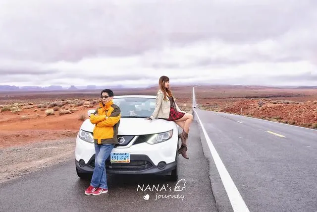
Monument Valley: Eroded Art, Isolated Spires, American Highways
Monument Valley, an iconic American West landscape, is beloved by Hollywood. The famous "Forrest Gump" running scene was shot here.
Located on the border of Arizona and Utah, it was the farthest point of our trip, an hour behind (time zone). From the Grand Canyon to Monument Valley, via 160 to 163, it took over 3 hours with intermittent showers. The weather was bad. Many US attractions depend on weather; a bad day can ruin the visit. But we had no choice; we left it to fate.
No Three Mitts, Just American Highways!
Soon after entering Highway 163, huge solitary rock formations appeared on the desert—like isolated giant stones, oddly shaped, scattered on the barren land. We knew Monument Valley was near.
Our first target was the iconic three-mitt scene from "Forrest Gump." It's outside the park: don't enter the park gate, continue straight. No sign, but coordinates: 37.102750, -109.989056.
Weather let us down: drizzly, low clouds hiding the tops of the rocks. When we reached the spot—what? The three mitts were invisible!
Without the mitts, it became a showcase for American highways.
Looking around, all the Monument Valley spires were capped by clouds.
When you can't get what you want, enjoy what you have. So my dad and I started photographing the highway.
We took our only (camera) group photo together. Because the road was busy, we posed in the parking area.
"Come on, get out for a photo!" I fumbled with the tripod while choosing a spot.
"Stand here, not front-facing, slightly sideways." Seeing my dad not moving, I forced him to the front of the car.
"I don't want to..."
"Stop being tsundere! The road is so beautiful! Can't we have a group photo! ... Fold your arms, yes, bend one knee and put it over the other."
Under my direction, we finally got our photo!
Though cold and drizzly, it didn't stop my enthusiasm for highway photos. A telephoto lens gave a great effect—cool American West road style.
Coincidentally, this was the only place in the American West where we took highway photos. Most roads are highways, not as grand as expected; many are just ordinary roads.
After photos, I was numb with cold. With this hazy view, let's go into the valley.
That's how the American West is in this season: hot with sun, cold with rain—freezing wind drops temperatures to single digits.
Staying in a Navajo Scenic Room
Monument Valley's highlight is its viewpoint hotel; every room has a dedicated view. But it's hard to book; many never get the chance. Lucky to get a room, I decided to enjoy it in the bad weather.
Monument Valley is in the Navajo Nation, the largest Native American tribe in the southwestern US. It's not a national park but a separate attraction. You must buy a ticket ($20 per car, 1-4 people) whether or not you stay at the hotel.
The hotel is Navajo-themed, with warm heating—felt like home. The staff were very friendly—one of the warmest stays.
The hotel has its own museum and gift shop selling ethnic items, from decorations to personal accessories, and interesting rocks—I spent a long time browsing.
There were many quirky dolls with tribal flavor—the only place full of Native American atmosphere.
You might wonder: are the staff Native American? Traditional attire is rare nowadays; they dress like us, indistinguishable.
Outside the restaurant, there's an open deck, the best viewpoint in the hotel, overlooking the entire valley. If it weren't raining, I'd have enjoyed a cup of American coffee there.
By the way, the hotel restaurant is reasonably priced—not expensive at all. A hot chocolate is only $2.
The red earth of Monument Valley was wet with rain; the defiant isolated spires were hidden. Standing on the deck, the wind was fierce—unbearably cold. Probably no valley views today.
Back in the room, we enjoyed the panoramic view. The room was simple but cozy. Twin beds in the US are quite large. There was a capsule coffee machine with Starbucks capsules.
Opening the door, you see the whole valley—but not today. I've accepted weather is luck.
As recommended, dinner at the hotel was cheap and delicious. We ordered a fried meat chop and a stew, with fries, vegetables, and bread—large portions.
Sides, salad, and soup were self-serve and unlimited. I liked the tomato soup.
That $2 hot chocolate was excellent—I had another!
Clouds Part, Mysterious Valley
At dusk, a hint of deep blue appeared in the sky. Clouds seemed to break. My dad was already napping, but I suggested we explore.
A small road beside the hotel leads into the valley. It's a single, steep, rough road. After rain, it was muddy—we drove under 20 mph, watching for big rocks.
Before entering, study the simple map provided. The valley is easy to get lost in; with ample time, consider a guided tour.
Monument Valley is a group of giant sandstone monoliths, reddish due to iron oxides from weathered sandstone. The relentless wind has shaped these bizarre isolated peaks.
One peak looks like a thumb—this is a Monument Valley icon!
Driving on the muddy, bumpy road, I understood why the guided tour uses Jeeps. Even SUVs struggle, but we cautiously ventured deeper.
Most peaks have names; we didn't bother. As it grew dark, driving through the valley became an adventure—you never knew when a big pothole would appear.
We reached our limit when puddles were too deep to cross. I'm not familiar with my car, and it was getting dark—end of our adventure.
We turned around and drove out. The weather cleared just then. At night, I checked from the balcony—no stars, but low clouds had dispersed. Hoping for a clear morning.
Finally Got the Perfect Three Mitts~
Hoping for clear weather, I woke early for sunrise. So glad we stayed inside the valley—I could wait in bed, half asleep, for the sunrise.
A ray of light broke through the thick clouds—the sun was coming out!
Not a spectacular sunrise, but it brought warmth and hope of beauty.
The sky gradually cleared. I dragged my dad to the highway to try our luck. Clouds were still low, but the distant sky was blue—every second of change thrilled me.
Sunlight gently bathed the monoliths, warming the world.
At yesterday's "Forrest Gump" spot, the clear weather was breathtaking. The soft morning light on the three mitts was gentle and beautiful.
Monument Valley's three mitts and the highway—in the hazy morning, like a feast of eroded art, dazzling and charming.
Morning is truly the best time for classic shots. Glad we got up early for this rare beauty.
I wanted portraits, but the wind was so strong it nearly blew us away.
A few American photographers with tripods smiled at each other, all capturing highway shots.
The clouds finally dispersed, showing us Monument Valley's sunny side before we left. The red rocks under blue skies were even more colorful.
After photographing the three mitts, we returned to the hotel to pack and leave.
One last glance from the balcony—now in backlight, ideal for visiting the valley interior in the afternoon.
We had a 1 PM Antelope Canyon reservation, a 2-hour drive away. No time to delay. Leaving the valley, we retraced our route, then turned onto Highway 98 toward Page.
Soon after leaving, the clouds returned, and it started snowing on Highway 98. This road winds through mountains but is easy to drive. We arrived in Page on schedule.
Page: A Feast of Earth's Art
Page, a famous little town in the American West, is home to two of the most famous attractions: Antelope Canyon and Horseshoe Bend. Many people stay here overnight; it's also the closest stop east of the Grand Canyon. Unexpectedly, the town didn't feel like the American West—I didn't even recognize it as a town at first (shame).
Page is well-located, connecting north and south east of the Grand Canyon. We weren't staying overnight; after visiting two spots, we'd continue north.
To avoid time zone confusion, we first went to Antelope Canyon to confirm the local time, so we wouldn't miss our tour. Then we drove happily to Horseshoe Bend, allowing 1 hour—should be enough. But we discovered Horseshoe Bend had been modified: private cars weren't allowed; everyone had to take a shuttle from a temporary parking lot in Page. A land-grab scheme. Annoyed, we went to the lot—the queue was insane! Shuttles came every 20 minutes and couldn't accommodate many people. We didn't have time; we had to return to Antelope Canyon for our tour first, then maybe Horseshoe Bend later. Plans changed—likely a late day.
Lower Antelope Canyon: A Dance of Light and Shadow
Antelope Canyon, long-awaited. A photographer's paradise, known for its beautiful canyon patterns and light. My dad was interested because he hasn't visited China's Yucha Grand Canyon yet.
This season, Upper Antelope Canyon has poor light, so Lower Antelope Canyon attracts more visitors—must book online in advance. Upper isn't empty; it hosts more group tours.
We arrived half an hour early. There are two tour operators next to each other. One is a shabby wooden shack with tourists waiting outside. The other, Ken's Tour (which I booked), has a comfortable waiting room—a big difference. Check in early to get a group number. Groups are limited to 10 people; about 10 groups start together, each with a guide.
In the waiting hall, I saw many visitors with dogs. Curious if dogs can visit? Answer: no; they must be boarded in the waiting area. Off topic: American dogs are also super-sized! !!!∑(?Д?ノ)ノ
Antelope Canyon is a world-famous slot canyon. Though in the desert, it was formed by flash floods scouring through soft sandstone. The inner walls look polished, as if ancient waves were frozen in stone. Sunlight creates different hues.
Upper Antelope Canyon is above ground; Lower is below ground. All tours must be led by Navajo guides for safety. Though in the desert, rain can cause floods—accidents have happened.
Our 13:00 group was number 8, with 6 people. I thought being later and fewer would make photography easier. But groups don't go in order; our small group assembled quickly and entered early, but then we got sandwiched between other groups—painful.
Lower Antelope Canyon is underground. We descended a staircase. The guide didn't let us take photos initially. The canyon appeared as a narrow crack, mysterious.
Finally inside, I never imagined such an artistic feast hidden underground. The walls twist and bend, light penetrates through cracks, reflecting on the patterns—colors layered, as if light is dancing along the lines. Stunning!
The canyon isn't straight; water and wind have carved irregular passages, like artworks on display, waiting for us to interpret abstract forms.


![Global Walk [12] the Walk of the World Season 1 Episode 3 Los Angeles](/img/ef9fbefc3126e1f7_s.webp?src=https%3A%2F%2Fdimg04.c-ctrip.com%2Fimages%2F0100j120009adiv2w5C12_W_320_0_Q80.jpg)