Westward Journey: Qilian Mountains - Zhangye - Jiayuguan - Dunhuang - Yumen Pass - Yadan Devil City - Delingha - Caka Salt Lake
During the National Day Golden Week, we embarked on a westward journey, covering a total of 4,110 kilometers over 8 days.
Day 1: Xi'an - Xining, 880 km, 11 hours, overnight in Xining;
Day 2: Xining - Qilian - Zhangye, 520 km, 10 hours, overnight in Zhangye;
Day 3: Zhangye - Linze Danxia - Jiayuguan, 270 km, 7 hours, overnight in Jiayuguan;
Day 4: Jiayuguan - Dunhuang, 380 km, 4 hours, overnight in Dunhuang;
Day 5: Dunhuang - Yumen Pass - Yadan Devil City, 180 km, 5 hours, overnight in Aksay;
Day 6: Aksay - Delingha, 500 km, 6 hours, overnight in Delingha;
Day 7: Delingha - Caka Salt Lake - Xining, 500 km, 6 hours, overnight in Xining;
Day 8: Xining - Xi'an, 880 km, 11 hours.
Attractions: Datong River - Jingyangling Pass - Lenglongling Gangshika Snow Peak - Menyuan Rapeseed Flower Fields - A'rou Monastery - Qilian Mountains Grassland
[Geography and Landforms: Qilian Mountains]
The Qilian Mountains are one of the major mountain ranges in China, consisting of multiple parallel ranges trending northwest-southeast and wide valleys, with an average altitude of 4,000-5,000 meters. They are located on the border between northeastern Qinghai Province and western Gansu Province, featuring towering snow-capped peaks, broad glaciers, and spectacular landforms.
The Qilian Mountains hold great historical significance for China, being the origin of the great national dream. Without the Qilian Mountains, there would be no Hexi Corridor or Silk Road. They also have special geographical significance, as the areas on their north and south sides differ greatly in terrain, administrative divisions, and dry-wet zones, serving as several important geographical boundaries: the boundary between the first and second steps of China's terrain; the 200 mm annual precipitation line; the boundary between internal and external drainage basins; the boundary between the Hexi Corridor and the Qaidam Basin; the boundary between Gansu and Qinghai provinces; and the boundary between Northwest China and the Qinghai-Tibet region.
The towering Qilian Mountains block the southeast monsoon from the Pacific Ocean, isolating the Gobi Desert of Inner Mongolia from the desert of the Qaidam Basin. The glaciers, rivers, and oases they create nurture the Hexi Corridor, connect the Silk Road, bring religion, and send jade... It is precisely because of the majestic Qilian Mountains and the birth of the Hexi Corridor that a rich cultural heritage has been deposited, giving rise to countless historical relics and sites, making the Qilian Mountains a blend of natural beauty and cultural richness.
Departing from Xining and heading north, we sped along the most beautiful National Highway G227, crossing the Daban Mountains (part of the Qilian Mountains).
At the foot of the mountain, people were harvesting rapeseed (9:50).
Encountered a tributary of the Yellow River: the Datong River (10:20).
Pastoral scenery of the Datong River Basin.
Standing at the Jingyangling Pass, gazing at the Lenglongling Gangshika Snow Peak of the Qilian Mountains (13:30).
Overlooking the Menyuan Rapeseed Flower Fields from the Daban Mountains viewing platform.
A'rou Monastery in Qilian County, said to have been the largest tent monastery in the world—quiet, solemn, and mysterious (14:45).
The Qilian Mountains Grassland, rated by Chinese National Geography as one of China's six most beautiful grasslands, stands out uniquely against the backdrop of snow-capped mountains (15:20).
Attractions: Zhangye Danxia - Jiayuguan - First Pier of the Great Wall
[Geography and Landforms: Zhangye Danxia] (9:00)
Danxia landforms are the product of long-term crustal movement, formed by red sandstone through prolonged weathering, erosion, and water dissolution, resulting in isolated peaks and steep, grotesque rock piles. Zhangye Danxia is located at the northern foot of the Qilian Mountains, developed during the Jurassic and Tertiary periods 200 million years ago. It is characterized by cross-bedding, steep cliffs, vertical joints, and vibrant colors, making it one of the largest and best-developed Danxia landform areas in China, with the richest variety of shapes. It is also the only composite area of Danxia landforms and colorful hills in China. It combines the grandeur, danger, strangeness, serenity, and beauty of Guangdong Danxia with the colorful brilliance of Xinjiang's Colorful City. The diversity of colors, strong观赏性 (viewing appeal), and vast area surpass all others in the country. It has been rated by Chinese National Geography Magazine as one of "China's six most peculiar landforms," praised as "Zhangye's lattice-window palace-style Danxia landform, number one in China" and "Zhangye's colorful hills, number one in China." It has also been rated by National Geographic Magazine as one of the "World's Top 10 Geographic Wonders."
Filming location for Zhang Yimou's "A Simple Noodle Story."
[History and Culture: Jiayuguan] (16:40)
Jiayuguan is located at the junction of the middle and western sections of the Hexi Corridor, with a history of over 600 years. It is the first major pass and starting point of the western end of the Ming Great Wall, as well as a key fortress on the Silk Road. It is currently the best-preserved and most magnificent ancient military castle along the route, renowned as the "Majestic Pass."
[History and Culture: First Pier of the Great Wall] (18:50) "The First Pier of the Great Wall" is the first watchtower of the Ming Great Wall from west to east, an important part of the Jiayuguan Great Wall defense system. It is 7.5 kilometers north of the pass, standing on a cliff nearly 80 meters high above the Taolai River, earning the title "the most perilous pier under heaven."
Attractions: Singing Sand Dunes / Crescent Moon Spring. Passed through Guazhou. Guazhou is a county under Jiuquan City, Gansu Province, located at the western end of the Hexi Corridor. It has been a transportation hub for east-west travel since ancient times and a commercial center on the ancient Silk Road. Guazhou County is famous for its abundant melons and fruits, known internationally for its "fine melons" since ancient times. Its "Guazhou Honey Melon" has 4 series with over 30 varieties, featuring crisp texture, juicy, sweet, refreshing, with sugar content reaching 14%-19%, making it an excellent summer refreshment.
[Geography and Landforms: Singing Sand Dunes / Crescent Moon Spring] (16:20)
Located seven kilometers south of Dunhuang city, Singing Sand Dunes and Crescent Moon Spring are like twin sisters in the Gobi Desert, becoming a wonder because "the sand never fills the spring, and the spring never dries up." The origin of this peculiar landform remains inconclusive: some say it is a remnant lake of an ancient river channel; others say it is a fault seepage spring; some claim it is a wind-eroded lake; and others believe it was artificially excavated.
The Singing Sand Dunes undulate with ridges as sharp as blades, like a golden dragon lying across the land. It is said that in midsummer, when people ride the sand and slide down from heights, the sand roars like thunder.
Crescent Moon Spring is embraced by the Singing Sand Dunes, resembling a crescent moon, quietly leaning against the dunes, giving a feeling of "the Singing Sand Dunes soothe the heart, and Crescent Moon Spring purifies the soul."
Attractions: Mogao Caves - Yumen Pass - Dunhuang Han Great Wall - Dunhuang Yadan
[History and Culture: Dunhuang Mogao Caves] (10:10)
The Mogao Caves, commonly known as the Thousand Buddha Caves, are located at the western end of the Hexi Corridor in Dunhuang. They were first built during the Former Qin period of the Sixteen Kingdoms. According to legend, the first cave was carved by a monk named Le Zun, whose act inspired many others. From then on, it continued unabated through the Sixteen Kingdoms, Western Wei, Northern Wei, Sui, Tang, Five Dynasties, Song, Western Xia, and Yuan dynasties, spanning over a thousand years, forming a huge scale with 735 caves, 45,000 square meters of murals, and 2,415 painted clay sculptures. It is the world's largest and richest Buddhist art site, the best-preserved Buddhist cave art treasure house, and one of China's four major grottoes (Dunhuang Mogao Caves, Luoyang Longmen Grottoes, Datong Yungang Grottoes, and Maijishan Grottoes). In 1987, it was inscribed on the UNESCO World Heritage List.
[History and Culture: Yumen Pass] (13:38)
"The Yellow River rises to the white clouds, a lone city among ten-thousand-foot mountains. Why should the Qiang flute complain about the willows? The spring wind never crosses Yumen Pass." This popular poem "Liangzhou Ci" by Tang Dynasty poet Wang Zhihuan sparked our interest in visiting Yumen Pass. We drove nearly a hundred kilometers across the Gobi to reach this ancient pass.
The Yumen Pass site is located at the westernmost end of the Hexi Corridor, on the south bank of the Shule River, about 90 kilometers from downtown Dunhuang, and about 150 kilometers west of the eastern edge of Lop Nur. It lies in a natural geographical environment of Gobi, desert, rivers, and lake beaches.
Yumen Pass is also known as Xiaofangpan City. After Zhang Qian's mission to the Western Regions, the Silk Road was opened, and cultural and trade exchanges between East and West flourished. To ensure the smooth flow of the Silk Road, Emperor Wu of Han ordered the construction of Yangguan and Yumen Pass.
Yumen Pass served as the strategic throat for the Silk Road leading to the northern route of the Western Regions. At that time, the pass bustled with camel bells, human shouts, horse neighs, caravans, and envoys coming and going—a scene of prosperity. Now, standing on the observation platform of the ancient pass, looking into the distance, swamps are everywhere, ravines crisscross, broken walls of the Great Wall are faintly visible, beacon towers stand upright, populus euphratica trees are tall and straight, and the scene is desolate... "The spring wind never crosses Yumen Pass" is a realistic portrayal of this ancient pass today.
[History and Culture: Dunhuang Han Great Wall] (14:15)
The Han Great Wall is a great creation of the ancient Chinese working people. As early as the Western Han Dynasty, the central government built nearly a thousand kilometers of the famous Han Great Wall through the Hexi Corridor, passing through Zhangye, Ejina Banner, Jinta, Jiayuguan, Yumen, Anxi, to Dunhuang, in order to resist and defend against harassment by the Xiongnu, strengthen border control, stabilize the people internally, consolidate centralized power, and ensure the smooth operation of the Silk Road. Watchtowers and forts were extended to Lop Nur and the ancient Loulan Kingdom. The existing Han Great Wall main and branch lines within Dunhuang stretch for hundreds of miles. Despite two thousand years of wind and sand, some sections remain as solid as rock, standing in the Gobi desert. With the passage of time, most of the Great Wall has been leveled, but traces remain, and some parts are relatively well-preserved.
[Geography and Landforms: Dunhuang Yadan] (15:20) Yadan landform is a unique landform formed by wind erosion, also known as "wind-eroded ridges." In extremely arid areas, some dry riverbeds often crack due to drying, and wind erodes along the cracks, making them larger and larger, turning the originally flat ground into many irregular ridges and shallow wide grooves. This fragmented terrain is called Yadan landform.
Dunhuang Yadan National Geopark, commonly known as Dunhuang Yadan Devil City, is an important part of the western tourism route of Dunhuang. It is 168 kilometers away from downtown Dunhuang, located northwest of Yumen Pass. The park is divided into north and south zones, about 25 kilometers long from east to west and about 13 kilometers wide from north to south. Dunhuang Yadan National Geopark, with its unique desert scenery, diverse geological wonders, and ancient folk legends, has attracted countless brave explorers to explore the mysteries of nature. It is also the first national geopark named after Yadan in China and even the world.
Dunhuang Yadan is located at the junction of Xinjiang and Gansu, part of the ancient Lop Nur. It is currently the largest Yadan landform community in Asia, with the most mature geological development and the highest ornamental value. The soil is hard and light red, forming a strong contrast with the gray Gobi desert. The shapes are rich and varied, like pagodas, palaces, golden peacocks, golden lions, fleets... vivid and lifelike. It is said that when sandstorms occur, the entire Yadan emits eerie sounds, and people who travel at night cannot find their way out, so locals call it "Devil City."
As it grew dark, coming out of the Yadan Geopark, the boundless Gobi showed only starlight, no streetlights. On the road ahead, the endless tail lights of cars looked like a huge fire dragon stretching into the distance. Drivers had to follow the tracks of the car ahead, relying on high beams to illuminate, slowly driving, vehicle after vehicle in a convoy.
Attractions: Talien Lake - Delingha Alien Ruins
In the morning, we had a bowl of beef noodles in Aksay (Kazakh Autonomous County) and started another day's journey.
Aksay Hotel (8:30)
Photo taken on the road from Aksay to Talien Lake.
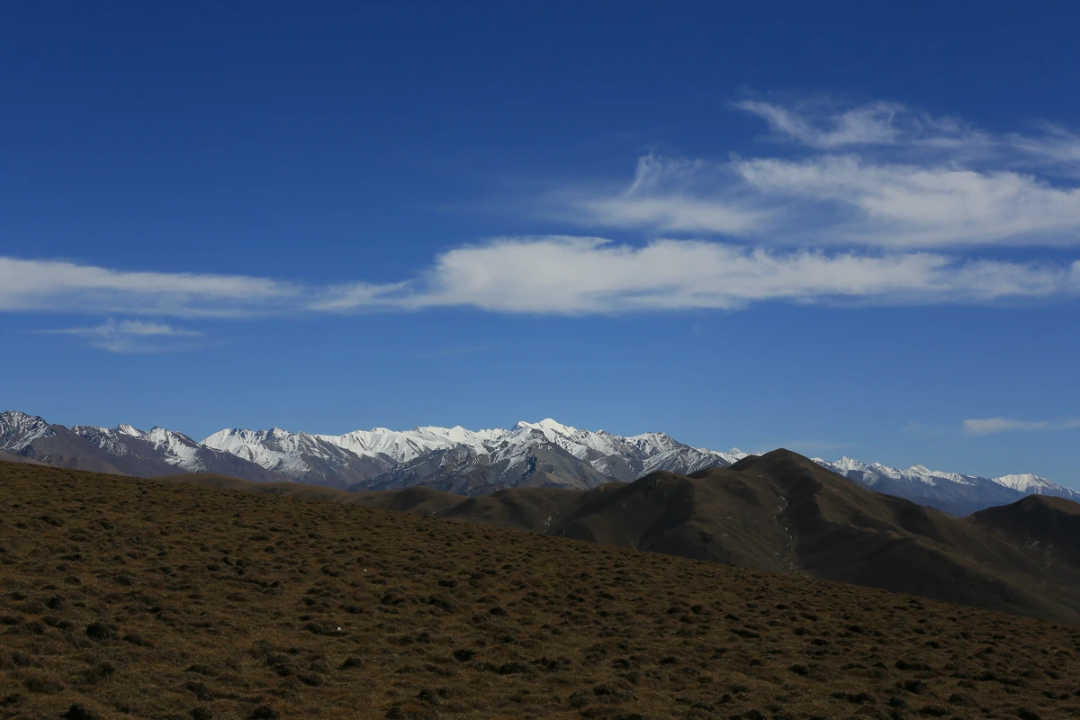
Crossing a high-altitude pass of the Qilian Mountains, without negotiation, we experienced a high-mountain blizzard unlike any we had ever encountered (12:15).
Photo taken on the road: "Alien Ruins & Talien Lake Scenic Area."
[Geography and Landforms: Talien Lake] (14:30)
In the northeastern part of the Qaidam Basin, on the Huaitoutala Grassland, there are two beautiful and tranquil lakes, one large and one small. One is salty, the other fresh, connected by water bodies, like two huge shining mirrors embedded in the vast Gobi and boundless grassland. They are Tuosu Lake and Keluke Lake, located at an altitude of 3,000 meters in Delingha City, Haixi Mongolian and Tibetan Autonomous Prefecture, collectively known as Talien Lake. Tuosu Lake is a typical inland saltwater lake, with a vast surface and open shores. Keluke Lake is a slightly salty freshwater lake, with clear water and a calm surface. They are like a legendary couple, one strong and one gentle, leaning on each other.
The vast surface of Tuosu Lake.
The gentle and beautiful Keluke Lake.
[Human Mystery: Delingha Alien Ruins] (15:50)
At an unknown time, a giant "desert crop circle" suddenly appeared overnight near the "Delingha Alien Ruins" in Qinghai. This phenomenon not only shrouded the cause of the "desert crop circle" in mystery but also added a "seemingly real" color to the "Alien Ruins." Humans have to associate this area with aliens.
The "Delingha Alien Ruins," famous since the 1970s, are located on the southern shore of Tuosu Lake at Baigong Mountain. From a distance, it looks like a pyramid. Inside three rock caves on the front of the mountain, there are many rusty red tubular objects that seem to be inserted directly into the rock. Scattered around the lake and caves are fragments resembling rusty iron and oddly shaped rocks. Some pipes even extend into Tuosu Lake. Scientists sampled and analyzed these tubular objects and found that iron oxide accounts for over 60% of their composition, while an element constituting more than 8% does not appear on the periodic table. People speculate that these mysterious elements might come from outer space, the deep sea, or the Earth's core... The ability to insert these tubes into hard rock without deformation may be due to these mysterious elements.
To date, the mystery of the "Delingha Alien Ruins" continues to perplex humanity: Where did the tubular objects come from? How were they inserted into the rock? What are the mysterious elements in the tubes?
Photo taken on the road from Talien Lake to Delingha.
Attractions: Caka Salt Lake
Photo taken on the road from Delingha to Caka Salt Lake.
[Geography and Landforms: Caka Salt Lake] (13:00) The Qinghai-Tibet Plateau was once a vast ocean. Long-term crustal movement lifted the ground to form the plateau, and the seawater left in low-lying areas formed salt lakes.
Caka Salt Lake is located at the eastern gateway of the Qaidam Basin, at an altitude of 3,100 meters. It is the only natural salt lake on the golden latitude line of 37 degrees north, famous for producing "daqing salt" (large green salt). Unlike other salt lakes, it is a brine lake with both solid and liquid phases, set among snow-capped mountains and grasslands rather than in the Gobi desert, making it highly scenic. The salt lake has a wide water area, with blue sky, white clouds, and snow-capped mountains reflected in the lake, picturesque and poetic, enjoying the reputation of "China's Sky Mirror." It has been rated by National Geographic Magazine as one of the 55 places to visit in a lifetime.
Small animals made of salt.
"Sky Mirror."
Salt precipitated from the lake.
Railway and small train extending to the heart of the lake.
After visiting Caka Salt Lake, we headed straight to Xining. Our vehicle perfectly completed a circle on the "Westward Route Map."
This self-driving loop started from Xining, crossed the Qilian Mountains, traveled west along the northern side of the mountains through the Hexi Corridor, reached Yadan in ancient Lop Nur near Dunhuang, then followed the Qaidam Basin, descended from the southern side of the Qilian Mountains through the Qinghai-Tibet Plateau, circling around the Qilian Mountains. It passed through three provinces (Shaanxi, Gansu, Qinghai) and four ethnic groups (Han, Hui, Kazakh, Mongolian), visiting over a dozen attractions. Along the way, we enjoyed various natural landscapes rich in profound scientific mysteries and explored numerous historical and cultural relics with deep cultural backgrounds. Travel is a process and a discovery; through travel, we discover, observe, learn, and reflect.


