Renting a Car for a Self-Drive Tour of Western Sichuan in Golden Autumn (1): Chengdu to Barkam, Taoping Qiang Village, and Bipenggou
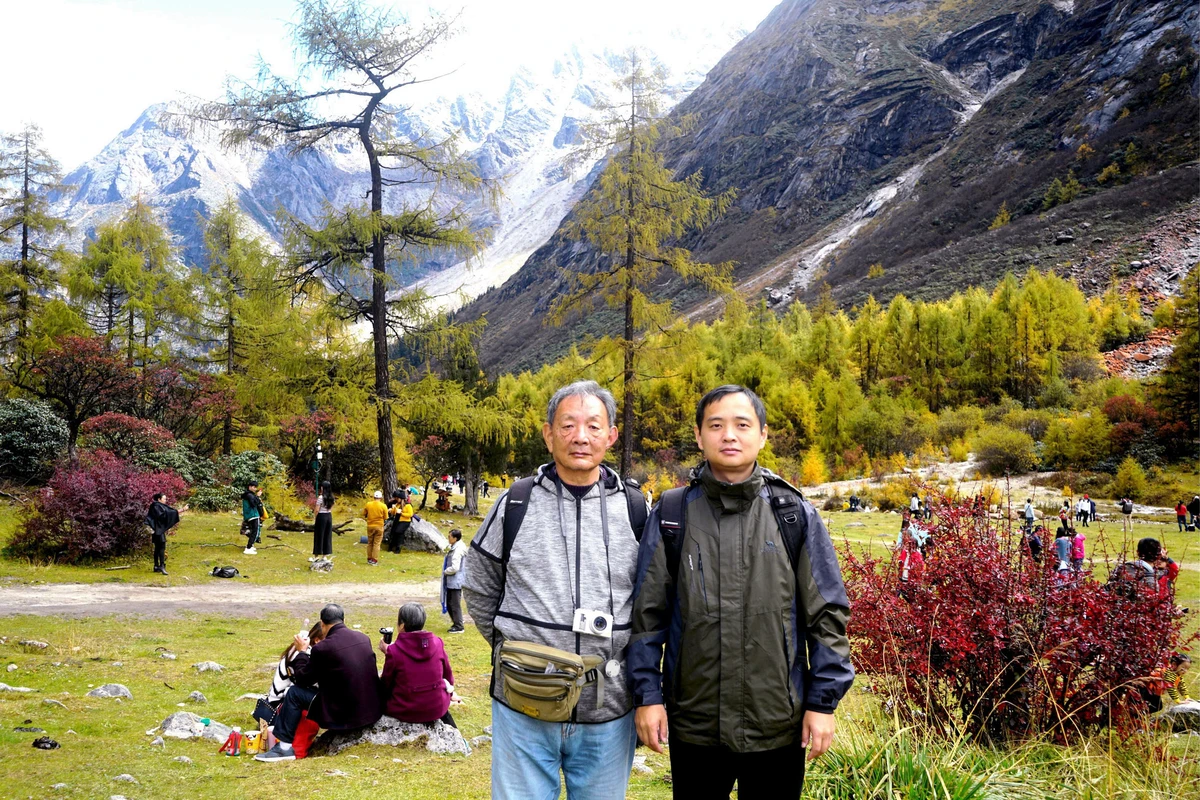
In the golden autumn of 2019, I rented a car and took a self-drive tour of western Sichuan, following the route: Chengdu → Dujiangyan → Taoping Qiang Village (Li County) → Bipenggou (Li County) → Barkam → Xiaojin → Danba → Bamei → Xinduqiao → Litang → Daocheng → Yading → Daocheng → Litang → Xinduqiao → Zheduo Mountain → Kangding → Hailuogou → Luding → Chengdu. This is essentially the small western Sichuan loop plus Daocheng (Yading). I was accompanied only by my eldest son, X.J., who was responsible for driving and all arrangements and expenses for the trip, while I planned the driving route.
X.J. was granted leave from October 4 to 14 and planned to invite me to drive through western Sichuan together, asking me to arrange the specific itinerary. He mainly looked forward to Daocheng (Yading). However, a trip solely to Daocheng (Yading) could not fill the 11-day holiday, so X.J. also proposed a vision: "Chengdu → Hailuogou → Kangding → Xinduqiao → Daocheng Yading → Garzê → Sêrtar → Miyaluo → Chengdu." The idea was to rent a car in Chengdu and spend the entire 11-day holiday on the road, with my help to enrich and perfect the plan. This is essentially the large western Sichuan loop plus Daocheng (Yading). However, after checking, I found that the essence of Garzê is all in Dawu, where the scenery is beautiful but very primitive, requiring hiking and camping, which is obviously not suitable for us. The main attractions of Sêrtar are the Buddhist Academy and the Sky Burial Platform, which also do not suit X.J., as he is not interested in temples—someone who would rather sit blankly in the square and bask in the sun in Lhasa than enter the Potala Palace. So I suggested switching to the small western Sichuan loop plus Daocheng (Yading). This route focuses on natural scenery, which better matches X.J.'s taste. Moreover, going clockwise on the small loop results in a gentler altitude rise, allowing gradual acclimatization to the plateau. This suggestion was finally approved by X.J., who was the boss and driver—both paying and laboring—and had the final say.
October 4 (D1): Today we set off for Chengdu. The flight, MF8401, was scheduled to take off at 7:35 AM. For convenience, I had stayed at X.J.'s home last night. Just after 5:00 in the morning, my eldest daughter-in-law, L.H., got up to prepare breakfast and boil dumplings. According to her hometown tradition, family members eat dumplings when traveling far. The little grandson also woke up early to see us off, filling us with deep familial warmth. Before 6:00, the ride-hailing car arrived. We bid farewell to L.H. and the grandson and set off.
At 6:20, we arrived at Gaoqi Airport, checked luggage, passed security, boarded at 7:05, and took off on time at 7:35. The flight was a Boeing 787, with individual video screens installed in the back of the front seats—my first time on a Boeing 787. At 10:40, we arrived on time at Chengdu Shuangliu Airport. The Chengdu branch of the car rental company sent someone to pick us up and took us to their store near the South Railway Station to complete the rental procedures. This company is headquartered in Xiamen, and we booked through the headquarters, receiving some discounts.
At 11:42, we drove off, heading roughly northwest through the Chengdu urban area, aiming for Dujiangyan. According to my planned itinerary, we intended to stop briefly at Dujiangyan to visit and have lunch, then head to Bipenggou, staying at the entrance tonight and entering the valley tomorrow morning. I visited Dujiangyan in 2001—it's a small scenic area, and a quick one-hour tour is sufficient. "Bipenggou" is adjacent to "Miyaluo," which X.J. originally suggested, but Bipenggou was developed later and is more pristine. A friend working in tourism in Sichuan recommended we choose Bipenggou.
At 12:10, we entered the Ring Expressway via the "Chengwenqiong Expressway Wenjiachang Toll Station" and then transferred to the "Chengguan Expressway" via the "Chengguan Expressway Chengdu Toll Station." At 12:53, we exited at the "Dujiangyan" toll station. During the National Day holiday, highways are toll-free. However, as soon as we entered Dujiangyan city, a large screen announced: "Today's Dujiangyan Scenic Area reservations are full, unregistered tourists please do not go to the scenic area." So our Dujiangyan plan fell through. Unable to enter the scenic area, X.J. decided to have lunch first, choosing "Spring Water Steam Stone Pot Fish." After eating, we felt it was average. He thought it was a local Dujiangyan specialty, but upon asking, we found it was Yunnan cuisine.
After lunch, we set off again. The first task was to refuel, as the car had very little fuel when we picked it up. However, there was traffic congestion everywhere, and several gas stations indicated on Baidu Maps were difficult to reach. In the end, we had to get on the expressway first, planning to find a service area later to refuel. So at 14:55, we entered the "Duwen Expressway" via the "Dujiangyan West" toll station, heading toward Wenchuan. The Duwen Expressway starts from Dujiangyan and ends at Wenchuan. It is an important part of the G4217 Rongchang Expressway and opened to traffic at the end of 2012. In 2001, when I traveled from Chengdu to Jiuzhaigou, I also passed through this area. At that time, we followed National Highway G213 from Dujiangyan to Wenchuan, driving along the Min River, and the scenery was very beautiful. This time, taking the expressway, we kept going through tunnels and saw little scenery. The area along the expressway was also the severely affected region of the May 12, 2008 earthquake, with collapsed mountains visible everywhere.
To refuel, we searched for service areas along the way. However, the Duwen Expressway has very few service areas. It wasn't until 15:38 that we encountered the first one, "Miansi Service Area." We hurried in, but there was already a long queue of cars waiting to refuel. Nearby is the hometown of Yu the Great, and a "Yu the Great Altar" is visible from the expressway.
After refueling, we continued. At 16:39, we reached the Wenchuan intersection, where the Duwen Expressway ends. We did not enter Wenchuan County but instead passed through the "Wenchuan Tunnel" westward, continuing along the G4217 Rongchang Expressway toward "Barkam." The road wound through numerous mountains, with the expressway alternating between tunnels and long bridges. The long bridges followed the curves of the valleys, turning steep ravines into flat roads.
The Rongchang Expressway runs parallel to National Highway G317, and we could occasionally see G317 flashing below us. Currently, the Rongchang Expressway only allows one-way traffic from Wenchuan to Barkam, with very few cars on it. However, the G317 below was extremely congested. At 16:52, due to a road closure ahead, we were forced to exit at the "Taoping Toll Station" and switch to G317 to continue west. At that moment, G317 was smooth in the east-to-west direction, but the west-to-east direction was backed up in a long line, all private cars returning to Chengdu after the National Day holiday. G317 is also known as the "Northern Sichuan-Tibet Route" or "Chengdu-Nagqu Route," starting from Chengdu and ending at Nagqu in Tibet.
At 16:55, we passed by "Taoping Qiang Village" and stopped to sightsee. This was not originally part of our plan, but since the Dujiangyan plan fell through, we had extra time, so we decided to stop briefly. "Taoping Qiang Village" is located in Li County, Aba Tibetan and Qiang Autonomous Prefecture, about 40 kilometers from the county seat, right by the side of National Highway G317. It is the only well-preserved ancient Qiang village in the world still inhabited, known as a "living fossil" of Qiang architecture and folk customs.
The current Qiang village is divided into a new area and an old area. The new area is located on a large flat area beside the national highway, freely accessible without tickets, and cars can drive directly in. It is clearly a recent construction for tourism development. The area mainly consists of hotels, inns, restaurants, and shops selling various ethnic handicrafts. During the National Day holiday, it was crowded with tourists.
The old Qiang village is located on the hillside behind the new area; this is the real "Taoping Qiang Village." The entire ancient village centers around a tall watchtower, with houses interconnected and passages leading in all directions. A radial road network leads from the central watchtower to various exits of the village, allowing locals to move freely while outsiders find it easy to get lost, as if entering a maze. Hence, Taoping Qiang Village is also known as the "Mysterious Oriental Ancient Castle." The buildings in the village, whether watchtowers or residences, are all built from local materials—slate stones from the surrounding mountains, bonded with yellow mud mortar. The old Qiang village area has been developed into a scenic spot, with tickets priced at 60 yuan per person. X.J. bought one ticket, while I showed my ID card (over 70 years old) to receive a "Ticket Discount Registration Form" for free entry. The form required my signature and included a note: "Self-responsible for safety." Compared to the bustling new area (commercial zone), the old Qiang village had few visitors, appearing quite desolate.
We didn't have much time, so after entering the village, we headed straight for the watchtower of the "Qiang King's Residence," the most representative watchtower in Taoping Qiang Village. The passages within the village were complex, with narrow, deep alleys. Some alleys even had buildings overhead, requiring us to go through houses and courtyards. Even with road signs along the way, we had to ask for directions frequently. The village still houses about a hundred families, and the locals are very simple and friendly to outside visitors.
In earlier times, the Qiang watchtowers were mainly for military defense. The watchtower of the "Qiang King's Residence" is about 30 meters high, with nine floors, each floor having embrasures on all four sides. It is the highest point in the Qiang village. We climbed to the top and looked out: below were dense clusters of houses; opposite was another watchtower. The Qiang village is situated in a deep valley, surrounded by high mountains shrouded in clouds and mist. The G4217 Rongchang Expressway and National Highway G317 wind along the deep valley. As the National Day holiday drew to a close, private cars eager to return east formed a long line on the national highway.
At 18:10, we left the Qiang village and continued west along G317. Ahead, a long "white dragon" appeared among the mountains—a unique highland cloud formation. In low-altitude areas (like our Fujian), mountain clouds and mist are often diffuse, with blurry boundaries, like ground fog climbing up the mountains. In high-altitude areas, the clouds on the mountains have clear boundaries, as if white clouds from the sky had fallen into the valleys.
At 18:25, we left G317 and re-entered G4217 via the "Xuecheng Toll Station." This section of the expressway was still one-way, only allowing traffic from east to west. Bipenggou is located in Putou Township, Li County, Aba Prefecture. When we passed the "Putou" exit, we didn't get off, thinking that as a famous scenic area, "Bipenggou" should have its own dedicated exit. But we were wrong—we couldn't get off when passing Bipenggou and had to continue to "Gurugou East" to exit, then turn back along G317 to reach Bipenggou, taking a long detour. At 19:44, we checked into "Shuimu Yuntian Hotel" near the entrance of the scenic area. The facilities were a bit simple, but the hygiene was acceptable. The hotel had an attached restaurant, and we had beef noodles for dinner.
This hotel was operated by local Tibetans. X.J. asked the front desk clerk to recommend the highlights of Bipenggou, but the clerk said, "Since I'm a local, I don't feel anything particularly special." This reminded me of visiting Yuanmou's "Maowu Soil Forest" in Yunnan in 2010, a national AAAA scenic area, where a staff member told me she had been herding sheep in the scenic area since childhood and never thought the "soil forest" was beautiful.
October 5 (D2): The hotel provided breakfast, reportedly at a standard of 10 yuan per person, starting at 7:30. We finished breakfast and checked out at 7:58. The front desk had changed to a "Han" girl, but upon asking, she said she was actually Tibetan but admitted to being assimilated into Han culture. The Bipenggou scenic area ticket office is 1.5 kilometers from the hotel, with a spacious parking lot. We arrived at 8:04. Because we arrived early, there were many empty parking spaces. The parking fee was 20 yuan per day. Visitors to the scenic area must take a sightseeing bus. The bus ticket is bundled with the scenic area ticket. I was exempt from the scenic area ticket (over 70), but still needed to buy a sightseeing bus ticket.
The earliest sightseeing buses depart from the ticket office at 8:00. There were many buses, and although tourists came in a steady stream, the buses came one after another, so we boarded soon after buying tickets. Before even boarding the bus, we could see that the scenery here was picturesque, the air extraordinarily fresh, and the small flowers on the hillside particularly vibrant.
At 8:30, we boarded the sightseeing bus. Bipenggou is a "natural ecological scenic area," and the sightseeing bus can only go 27 kilometers into the area, to the "Shanghaizi Tourist Service Center," and cannot go further into the core area of Bipenggou. As we rode the bus deep into the mountains, we saw that the vegetation, after autumn winds and frost, had begun to change colors, with red, orange, yellow, and green intermingling. The beautiful scenery of Bipenggou gradually unfolded.
At 9:17, we arrived at "Shanghaizi." This area is operated by "Li County Bipenggou Tourism Development Company." A notice board indicated that ahead is the core scenic area of Bipenggou, stretching 9 kilometers. Visitors can hike or pay to take eco-friendly battery-powered carts to continue. The scenery within Bipenggou is beautiful, roughly divided into 6 viewing areas, including 82 natural attractions and 5 cultural attractions. However, the most visited and famous spots in Bipenggou are only two viewing areas: "Panyang Lake" and "Yanzui Rock." The eco-friendly battery carts operate in two segments: the first from "Shanghaizi" to "Panyang Lake" is 4.5 kilometers, costing 20 yuan per person one way and 30 yuan round trip; the second from "Panyang Lake" to "Yanzui Rock" is also 4.5 kilometers, with the same fares.
The square at "Shanghaizi" was crowded with people, and long lines formed for ticket purchases and boarding. Most tourists were from Chengdu. Bipenggou is called the "Back Garden of Chengdu" because it is not far from Chengdu, making it suitable for weekend trips. During the National Day holiday, it was overcrowded. Sightseeing buses brought tourists one after another, but the scenic area had prepared many battery carts, which also shuttled tourists away one after another. We queued for tickets and then for the carts, spending a total of about half an hour.
At 9:46, we boarded the battery cart and arrived at the "Panyang Lake" viewing area in about 10 minutes. Probably due to the National Day holiday, the cart was full from the start and did not stop along the way. Thus, the attractions between Shanghaizi (starting point) and Panyang Lake (ending point) were inaccessible to us. When I visited Siguniang Mountain in September 2007, the scenic area shuttle buses operated like city buses, stopping at many spots along the way, making it convenient for tourists to get on and off. I guessed that if it weren't during the "Golden Week," the battery carts here would also have intermediate stops. The small square at the outlet of Panyang Lake was the terminal for the battery carts. Apparently due to an artificial dam, the outlet formed a small waterfall. Behind the waterfall, snow-capped mountains were visible, and a "white dragon" of cloud hung in the mountains, creating a spectacular view. Panyang Lake is named because bharal (blue sheep) often appear around it. However, at that moment, the lake was surrounded by people, and the bharal had probably long fled, leaving only a bharal sculpture still standing by the lake.
Panyang Lake is the largest lake in Bipenggou, at an altitude of 3,676 meters, 2-6 meters deep, with a water area of 450,000 square meters. The water is clear and transparent, typical of a high-altitude lake. We walked along the eastern shore of the lake from north to south, surrounded by towering snow peaks and lush primeval forests, the scenery very beautiful. The altitude of Panyang Lake is similar to that of Lhasa, Tibet, but we felt no unusual sensations; the air didn't seem缺氧, presumably due to the dense vegetation. While walking, I suddenly saw a girl blowing soap bubbles by the water. From a distance, it was a beautiful scene, and I took a quick photo with a telephoto lens.
Autumn had arrived in the mountains, and the vegetation was changing color. Conifers were still emerald green, but broad-leaved trees, lakeside shrubs, and grasses had already donned autumn attire, displaying varying shades of red, orange, and yellow. Lush green trees, deep red autumn leaves, clear blue lake water, azure sky, and white snow on the mountaintops—the scenery at Panyang Lake was stunning, like a dream, like a fantasy.
Wooden boardwalks were built around the lake. We walked along the long boardwalk, crossing marshes and wetlands, circling to the southern end of the lake. Opposite us was a large white sandy beach extending deep into the lake, with a crescent-shaped sculpture on it—also a beautiful scene. However, everywhere was crowded during the "Golden Week." We didn't go over, just took a photo from afar.
At 11:32, we reached the end of the boardwalk, which was also the departure point for the eco-friendly battery carts from Panyang Lake to Yanzui Rock. We bought tickets, queued, and boarded the cart again, this time heading to Yanzui Rock. The cart from Panyang Lake to Yanzui Rock also made no stops, covering the 4.5-kilometer uphill stretch all the way to the Yanzui Rock scenic area parking lot. However, the parking lot was still about 500 meters from the actual scenic area, and we had to hike uphill after getting off.
Around 12:00, we arrived at "Yanzui Rock," at an altitude of 3,837 meters. It is surrounded by snow-capped mountains, with a large high-altitude meadow in the middle. There is a large rock with the inscription "Yanzui Rock Nest," the official name of the scenic area, named because swallows build nests on the cliff. Yanzui Rock is adjacent to the famous "Siguniang Mountain" scenic area across the mountain. Behind the snow peaks to its west and south are the "Shuangqiao Valley" and "Changping Valley" of the Siguniang Mountain scenic area. Therefore, Bipenggou is also known as the "Beautiful Backdrop of Siguniang Mountain." During the National Day holiday, the vast meadow was filled with crowds.
It was already noon, so we had lunch first. Local villagers had set up stalls near the entrance of the scenic area selling teppanyaki grill. Tourists first selected raw ingredients, then handed them to a "chef" to cook. X.J. bought two large bowls of grilled items, including yak meat, pork belly, and potato slices, for a total of 100 yuan. The meat portions were generous, and the taste was excellent; I was very satisfied. X.J. thought it was a bit expensive, but considering it was a scenic area, I thought the price was reasonable. A month earlier, I had eaten burger sets at McDonald's in Xiamen North Station and KFC in Jiujiang Railway Station, each costing over 50 yuan, with burgers only the size of a small teacup. Compared to that, this large bowl of "teppanyaki" offered much better value.
Inside the fence in front of the grill stalls, there were tables and chairs. We ate while enjoying the beautiful scenery. On a nearby mountain, there was a waterfall with a drop of 360 meters, known as "Flying Dragon Waterfall." The water poured down a sheer cliff, disappearing into the jungle after several rock tiers, like a white dragon flying among the mountains. On the opposite mountain, there was a red rock gully, where a glacier meltwater stream flowed down from the mountaintop. Both sides were covered with red stones. The stones appear red because they are coated with a type of red algae that demands high environmental quality; even slight pollution prevents their survival. The presence of red stones indicates the excellent environment at Yanzui Rock.
The two of us walked slowly around the large meadow, stopping from time to time to admire the scenery and take photos. At Yanzui Rock, which is higher in altitude than Panyang Lake, the autumn colors were even more intense. Most of the trees on the mountains had changed into autumn attire, and because the leaves changed colors gradually, even red, orange, yellow, and green came in various shades. Looking around, we saw bright red, light red, orange-red, orange-yellow, golden yellow, light yellow, mixed with the still-unfaded dark green, light green, and yellowish-green, interweaving layer upon layer, colorful and splendid, bringing us surprise after surprise. The beauty of autumn leaves is not inferior to spring flowers. Truly, "Once a year the autumn wind blows, unlike spring light, yet surpassing spring light!"
It took about 80 minutes to walk around the meadow. At an altitude of over 3,800 meters, walking for so long was tiring, requiring frequent heavy breathing. During the National Day holiday, everywhere was crowded. When I asked a few people, they all said they were from Chengdu. Some families traveled with children and elderly, and some even brought babies a few months old. When I asked about altitude sickness, they said it was no big deal; altitude sickness doesn't come immediately but needs a process to develop. They don't stay very long up here, so they go down before it hits. In the middle of the meadow, there was a clear stream, sourced from the surrounding snow peaks, which is probably also the water source for Panyang Lake.
At 14:10, we prepared to take the battery cart down the mountain. However, by then, the queue of tourists waiting for the cart stretched nearly 600 meters, from the parking lot to the entrance of Yanzui Rock, past the "grill stalls," and extended about a hundred meters further inward. We had no choice but to line up obediently, sometimes standing, sometimes shuffling forward. However, while shuffling, we could see the "red stones" close by. After queuing for about 40 minutes, we finally boarded the cart. To our surprise, after arriving at Panyang Lake, we had to queue again. The line here had already exceeded the north-south length of Panyang Lake, so we had to continue standing. Eventually, we managed to board. At 15:34, we arrived at the "Shanghaizi" parking lot. Here, transferring to the sightseeing bus was very smooth; basically, the buses were waiting for people, so we could board immediately.
At 16:25, the sightseeing bus arrived at the "Bipenggou Scenic Area Ticket Office" parking lot. We found our car. X.J. felt very tired from the long periods of standing and, for driving safety, decided to rest briefly in the car. We set off again at 16:50. Exiting the Bipenggou scenic area entrance, we turned left onto National Highway G317, heading for "Barkam," the capital of Aba Autonomous Prefecture, where we planned to stay overnight. At 17:22, we passed through "Gurugou," a fairly nice little town. At 17:59, we passed through Miyaluo Town. Compared to the commercialized Gurugou Town, the buildings in Miyaluo Town were more stylish and refined. Gurugou, Miyaluo, and Bipenggou are close in distance and similar in scenery—visiting just one of these three places is sufficient. At 18:20, we entered the G4217 Rongchang Expressway again (this section is also called the Wenma Expressway) via the "Jintouzha" toll station. At 18:25, we passed through the Zhegu Mountain Tunnel. At 18:55, we exited at the "Barkam East" toll station, where the "Wenma Expressway" ends. Currently, the Rongchang Expressway has only been built this far.
At 18:57, we entered the urban area of "Barkam." At 19:03, we checked into "Haoting Mingren Hotel." Our room was on the second floor of an annex without an elevator. The room was small, but the facilities were acceptable. Around 20:00, we had dinner at "Luxi Fat Beef" next to the hotel. We ordered a hotpot set for two, with delicate dishes but a limited portion of beef. The beef was arranged in a shape resembling a Tibetan girl offering a hada scarf.


