Heading West: A Loop through Western Sichuan (Part 2) (9-Day Self-Drive Small Loop in Western Sichuan)
D6 (Day 5): Danba—Jiaju Tibetan Village—Mount Siguniang (Overnight)
Danba County is an emerging tourist destination.
Today we visit Jiaju Tibetan Village to see the unique Tibetan houses, watchtowers, and dwellings.
Jiaju Tibetan Village is located north of Danba County town.
The roads within Danba's Jiaju Tibetan Village are quite rugged, so visitors should wear comfortable shoes.
Bring food, water, trekking poles, and portable oxygen canisters.
Depart at 8:30.
Jiaju Tibetan Village is northeast of Danba County.
From Danba County town, take G248 Xihe North Road, then Jiajucheng Hua Road to reach Jiaju Tibetan Village (Visitor Center Parking Lot, 4.6 km, 15 minutes, 3 traffic lights).
From the county town, head west, turn right at the west end onto National Highway 248 north, cross the Jiarong Bridge, drive 2.1 km, go straight across the bridge, then follow Jiajucheng Hua Road to the scenic area entrance.
The ticket seller checked our ID cards and told us we could drive into Jiaju Tibetan Village with our IDs.
The barrier lifted and let us into the mountain.
Jiaju Tibetan Village, 4A grade.
Address: Niega Township, Danba County, Ganzi Tibetan Autonomous Prefecture.
Opening hours: Open all year round, all day.
Ticket: 50 RMB/person, sightseeing bus 35 RMB.
Seniors aged 60 and above (with senior card or ID) can purchase discounted tickets.
Jiaju Tibetan Village is located within Danba County, Ganzi Prefecture, about 8 km from the county town.
It covers an area of about 20 square kilometers.
The altitude of Jiaju Tibetan Village is around 2000 meters.
“Jiaju” means “a hundred households” in Tibetan. True to its name, over 100 Jiarong Tibetan houses are scattered on the hillside stretching nearly a thousand meters from the Dajin River Valley to the foot of Kapama Peak.
Image: Jiarong Tibetan houses scattered on the hillside from the Dajin River Valley to the foot of Kapama Peak.
Buy tickets at the Jiaju Tibetan Village Visitor Center ticket office (if not driving, you need to buy a sightseeing bus ticket).
The scenic sightseeing bus stops at Viewing Platform No. 1 and No. 2, with the final stop at Viewing Platform No. 3.
Jiaju Tibetan Village has a total of 9 viewing platforms (we visited 6).
For self-driving, it is recommended to drive first to Viewing Platform No. 3.
Leaving the visitor center at the foot of the mountain, turn right and drive 6 km along the winding mountain road to Viewing Platform No. 3.
The entire route inside Jiaju Tibetan Village is paved with asphalt, but some turns are very sharp and slopes are steep.
The car first passes Viewing Platforms No. 1 and No. 2.
We did not stop and drove straight to the parking lot of Viewing Platform No. 3. It has about 10 parking spaces.
The view of the village from Viewing Platform No. 3 is still relatively narrow.
Image: Viewing Platform No. 3.
To reach a higher viewing platform, you need to hike uphill.
Looking up, there is another viewing platform on the mountain.
Walk 10 meters forward from Viewing Platform No. 3 and you will see a stone staircase leading up. Follow this path uphill, passing by a Tibetan house.
This house covers about 200 square meters, is 3 stories high, and about 12 meters in total height.
Jiaju Tibetan Village features traditional stone-wood architecture.
The exterior walls are made of stacked stones, some painted white; wooden doors, windows, and frames are often painted red.
Image: A standalone Tibetan house.
Image: Exterior walls of stacked stones, some painted white; wooden doors, windows and frames often painted red.
After a brief stop for photos, continue up the stone steps to a three-way junction.
To the left, a small path leads to two more viewing platforms in the distance.
We didn't know their numbers, so we called them No. 4 and No. 5 viewing platforms.
Image: No. 4 and No. 5 viewing platforms?
On the slopes along the path to the viewing platforms, wildflowers are in bloom (some may be artificially planted).
From Viewing Platform No. 4, you can see scattered Tibetan-style buildings on the entire hillside, some dense, some sparse.
In front, there is a watchtower with a roof shaped like a fortress.
Danba is known as the “Land of a Thousand Watchtowers,” and Jiaju Tibetan Village also has watchtowers.
Ancient tall watchtowers were used for defense, while Tibetan houses were for living. Over time, as wars decreased, watchtowers and houses gradually merged into fortified dwellings.
Some say Danba's watchtowers are mostly relics from the Jinchuan Campaigns of the Qing Dynasty.
Image: Tibetan house in front of Viewing Platform No. 4.
The farthest Viewing Platform No. 5 along the small path is relatively large and even has a roof.
About ten meters away, there is a wall.
Cars cannot reach Viewing Platforms No. 4 and No. 5; only small footpaths lead there.
Further in the distance, there is another viewing platform on a higher mountain.
We returned the same way to the Y-shaped intersection. The right side was the path we came from. Taking the left stone-paved path leads to this viewing platform (the one we saw from Viewing Platform No. 3).
I'll call it Viewing Platform No. 6.
There is a lush “Welcome Pine” tree here, with a backdrop of green mountains.
Image: “Welcome Pine”.
Looking up from below this viewing platform, we noticed that to reach it, you need to exit through an opening in the wall. The exit has barbed wire (already broken through). Strange!
Walk 10 meters to the right through the gap in the barbed wire to reach Viewing Platform No. 6.
The view from Viewing Platform No. 6 is excellent, unobstructed, allowing you to see farther and higher—more Tibetan houses, clustered or standalone, and several watchtowers on the distant mountaintop.
The Tibetan houses are surrounded by patches of forest, and the colorful houses blend harmoniously with the green vegetation.
Higher up on the mountain, there are faintly visible viewing platforms, probably No. 7 to No. 9.
Image: From Viewing Platform No. 6, you can see farther and higher Tibetan houses, with several watchtowers on the mountaintop.
Beside Viewing Platform No. 6, there is a winding mountain road.
If you take the small path from Viewing Platform No. 6 back to Viewing Platform No. 3, it is a long staircase.
We chose to walk down the winding mountain road instead of backtracking.
First, a section of gravel road.
A small car drove up from below.
At a fork, we were closer to the Tibetan houses, and the view was clearer.
Image: Tibetan houses by the roadside.
Turn right onto an asphalt road and walk downhill, passing a Tibetan house with a red exterior wall.
Image: Tibetan house with red exterior wall.
After a 20-minute walk, we reached Viewing Platform No. 3.
Then drove to Viewing Platform No. 1 and parked.
From the mountaintop to the foot, there are three villages.
Many Tibetan-style houses in the village have been turned into distinctive guesthouses.
Image: Guesthouse by the village road.
Some guesthouses have their own parking; others park on the roadside.
After visiting Jiaju Tibetan Village in person, we found that only from Viewing Platforms No. 4, No. 5, and No. 6 can you get a broad view of the village and watchtowers; from Viewing Platform No. 3, you can see a section of the village below; Viewing Platforms No. 1 and No. 2 are right next to Tibetan houses.
Viewing Platform No. 1 has a platform for viewing.
Up close, the Tibetan houses have livestock pens on the ground floor, and above are the kitchen-living room, living quarters, prayer hall, and family watchtower. Some houses have a rooftop terrace.
The white walls are painted with patterns.
If interested, you can visit the developed model residential households for a “home visit” to see the interior decoration and structure; but be careful not to enter the prayer hall uninvited.
The local permanent residents are hardworking, brave, and hospitable Jiarong Tibetans.
Image: Guesthouse converted from a Tibetan house.
We spent two and a half hours visiting Jiaju Tibetan Village.
Remember a Tibetan phrase: Demo (goodbye).
Image: Village road in Jiaju Tibetan Village.
In the afternoon, we began the journey back toward Chengdu.
There are two routes from Danba to Chengdu:
1. The western Sichuan loop we took from Chengdu to Danba: Danba, Bamei, Tagong, Xinduqiao, Kangding, Ya'an, Chengdu, total about 520 km (counterclockwise).
2. From Danba via Xiaojin, Mount Siguniang, Wolong, Dujiangyan to Chengdu, total 390 km.
There is also a Tibetan-Qiang cultural route: Xiaojin County, Mount Siguniang Scenic Area, then via Barkam, Li County, Wenchuan, and the Dujiangyan-Wenchuan Expressway to Chengdu.
All three routes have decent national highway conditions.
We planned to stay overnight at Mount Siguniang Town tonight.
Left Jiaju Tibetan Village at 1:00 PM and drove downhill to the Mount Siguniang Scenic Area ticket office in Xiaojin County.
Mount Siguniang Scenic Area is east of Danba County.
* From Jiaju Tibetan Village (east), via China Giant Panda Avenue to the Shuangqiao Valley ticket office: 115 km, 3 hours 10 minutes, 11 traffic lights.
Not far east of Danba (on the way to Xiaojin), there is a [Viewing Platform No. 1].
Considering that the road from Danba (altitude 1860 m) to Mount Siguniang (Rilong Town altitude 3100 m) is uphill all the way, we couldn't go fast, and we didn't want to arrive too late at the accommodation; also, the village road to Zhonglu is steep and narrow. We gave up visiting the watchtowers.
A road sign indicated we were entering Xiaojin County.
Passing through Xiaojin County, we saw many stalls by the roadside with signs saying “Xiaojin Apples.” Xiaojin County is known as the “Hometown of Apples,” and its apples are famous for their color, fragrance, and taste.
We bought a few jin (1 jin = 0.5 kg, 3 RMB per jin).
Around 4:00 PM, we arrived at the Mount Siguniang Visitor Center. At the ticket office, we pre-booked tickets for tomorrow's Shuangqiao Valley Scenic Area.
Shuangqiao Valley: Full-price ticket 80 RMB/person, discounted ticket 40 RMB/person, sightseeing bus 70 RMB/person.
(The Mount Siguniang Scenic Area includes three valleys: Shuangqiao, Changping, and Haizi, each sold separately.)
There are daily long-distance buses from Chengdu to Mount Siguniang Town.
From Chengdu via Rongchang Expressway to Shuangqiao Valley Scenic Area: 211 km, about 4 hours by car.
Near the visitor center, we saw several guesthouses and also a high-end hotel.
We chose a guesthouse a few hundred meters from Shuangqiao Valley Scenic Area.
The altitude at the entrance of Shuangqiao Valley is about 2900 m.
[If staying at a guesthouse near Mount Siguniang Town, it is another 7 km drive and the altitude is 300-400 m higher.]
After checking in, we felt it was still early and the sky was clear.
We decided to go to “Cat Nose Ridge” (Mao Biliang) to see the magnificent view of the four peaks of Mount Siguniang and the sunset.
(Cat Nose Ridge is about 10 km east of Mount Siguniang Scenic Area, right by the main road.)
From the entrance of Shuangqiao Valley Scenic Area, drive east onto Panda Avenue. After crossing the mountain, about ten minutes later, you'll see a small parking lot on the left side of the road on a high slope (can park about 20 cars). This is “Cat Nose Ridge Ground Parking Lot.”
There is a stone marker by the roadside with the words “Mount Siguniang Cat Nose Ridge.”
Cat Nose Ridge is located near Provincial Road 33 in Xiaojin County, Aba Tibetan and Qiang Autonomous Prefecture. It is a必经之地 from Rilong Town to Balang Mountain.
From Cat Nose Ridge, you can see the magnificent view of the four peaks of Mount Siguniang. It is a great spot for photography.
This is also the best place to view the full panorama of Mount Siguniang, sunrise, and sunset; at sunset, you might also see the “golden mountain” phenomenon.
From the roadside, looking into the distance, the mountain in front is Cat Nose Ridge, and the four mountains behind are Mount Siguniang.
The white snow on the top of Yaomei Peak is clearly visible.
The white snow on the top of Yaomei Peak is clearly visible.
Yaomei Peak is the main peak of Mount Siguniang and the highest peak of the Qionglai Mountains, the second highest peak in Sichuan after Gongga Mountain (the “King of Sichuan Mountains”), hence known as the “Queen of Sichuan Mountains.” On clear, cloudless days, you can even see her from downtown Chengdu.
Image: Mount Siguniang.
Mount Siguniang is located in Rilong Town, Xiaojin County, Aba Prefecture. It consists of four continuous peaks, covered with snow all year round, like four graceful maidens with white veils, standing in sequence above Changping Valley and Haizi Valley. Hence the name “Mount Siguniang” (Four Maidens Mountain).
To capture a complete view of Mount Siguniang, the best spot is the “Cat Nose Ridge” viewing platform.
At the parking lot, we saw that the viewing platform is on a small hill.
The Cat Nose Ridge viewing platform is at an altitude of 4100 m, which is quite high; we didn't have enough time to climb, so we just enjoyed the view from the roadside parking lot.
Next to the parking lot, there was a row of stalls. We asked the stall owner and learned that sunset is around 7:00 PM.
More and more cars were parking by the roadside.
Considering we had a whole day to tour Shuangqiao Valley Scenic Area tomorrow, we needed to conserve energy, so we gave up watching the “sunset golden mountain” and drove back to the guesthouse.
The guesthouse has a restaurant on the first floor, and the food was good.
We needed to conserve energy, so we gave up watching the “sunset golden mountain” and drove back to the guesthouse.
The guesthouse has a restaurant on the first floor, and the food was good.
(Today's drive: 124 km, driving 4+ hours.)
D7 (Day 6): Full-day tour of Mount Siguniang Shuangqiao Valley Scenic Area (Overnight)
After getting up, we checked the items to bring for touring Shuangqiao Valley: warm clothing, portable oxygen canisters, trekking poles, raincoat, chocolate, beef jerky, milk candy, compressed biscuits, insulated water bottle...
Today's temperature: 13-22°C, large temperature difference between day and night. Partly cloudy.
Mount Siguniang Shuangqiao Valley Scenic Area, National 4A scenic spot.
Address: Rilong Township, Xiaojin County, Aba Tibetan and Qiang Autonomous Prefecture.
Opening hours: April 1–November 30.
Peak season ticket: Full-price 80 RMB, discounted 40 RMB, sightseeing bus 70 RMB.
Seniors aged 65 and above (with senior card and ID) free on national statutory holidays.
Shuangqiao Valley ticket sales: Spring/Summer: 7:30-15:30; Autumn/Winter: 8:00-15:00.
Sightseeing bus operating hours: 7:30–18:00.
Tips: Mount Siguniang Scenic Area adopts a full online real-name booking system. Enter with a second-generation ID card or paper ticket.
Parking: [Shuangqiao Valley Entrance Parking Lot] Reference price: 10 RMB for 3 hours, plus 2 RMB for each additional hour. Luggage storage: Free (reference price).
The core attractions of Mount Siguniang can be summarized as “Three Valleys and Four Peaks” – “Three Valleys” are Shuangqiao Valley, Changping Valley, and Haizi Valley; “Four Peaks” are Yaomei Peak (6250 m), San Guniang Peak (5355 m), Er Guniang Peak (5276 m), and Da Guniang Peak (5025 m).
After carefully comparing the three valleys, we chose Shuangqiao Valley route; Mount Siguniang cannot be seen inside Shuangqiao Valley, but we had already seen the snow-capped Yaomei Peak yesterday at Cat Nose Ridge.
Haizi Valley is suitable for hiking enthusiasts. Changping Valley requires a round-trip hike of 25 km, which cannot be done in one day; if riding a horse for several hours, you will definitely have back and buttock pain, plus safety concerns...
[Shuangqiao Valley – the most developed and easiest]
Stretching 34.8 km, Shuangqiao Valley is the most developed and richest in scenery among the three valleys. The entrance altitude is about 2900 m, and the tail at Redwood Forest reaches 3840 m, a vertical climb of nearly 1000 m.
Mainly features snow peaks, pastures, grasslands, and forests.
Shuangqiao Valley is the most beautiful valley of Mount Siguniang.
In spring and autumn, the valley is colorful and spectacular.
You can take a sightseeing bus directly to the tail of the valley and easily enjoy the wonders of Shuangqiao Valley.
Shuangqiao Valley tour route (textbook-level plan):
Walk 10 minutes from the guesthouse to the main entrance of Shuangqiao Valley Scenic Area.
We arranged a full day to tour, combining sightseeing bus and hiking:
1. At 8:30 AM, board the scenic area bus at the entrance. The bus travels 34.8 km, taking 45 minutes to the final stop: Redwood Forest Station.
The commentator on the bus introduced: Shuangqiao Valley gets its name from two wooden bridges in the valley: one made of willow wood, commonly called “Willow Bridge”; the other made of redwood, commonly called “Convenience Bridge.”
Tips: Pay attention to the scenery along the way on the bus (note beautiful sections) so you can plan to hike those sections on the return trip.
The tourism road in Shuangqiao Valley is a north-south road. Redwood Forest Station is at the northernmost part of Shuangqiao Valley.
The temperature here is 13°C.
Maybe because of the sun, we felt fine wearing a jacket and a vest (the down jacket in our backpack stayed unused).
* Redwood Forest, altitude 3840 m.
(The altitude of Redwood Forest is 200 m higher than Lhasa's 3650 m.)
Redwood Forest is the last scenic spot in Shuangqiao Valley. The redwood trees growing here are called Sichuan Redwood, a rare national second-class protected plant in Sichuan.
Redwood trees appeared almost simultaneously with the Quaternary glaciation, of great landscape value, and are another sacred tree besides the sea buckthorn tree in Shuangqiao Valley.
Some redwood leaves are turning golden (when the temperature drops further, the whole forest will be a beautiful golden color).
Image: Redwood Forest.
Image: Mountains around Redwood Forest Station.
North of Redwood Forest Station, there is a glacier viewing platform. It is a circular loop of about 1.5 km (we did not go).
We admired the snow-capped mountains in the distance and ate some chocolate and milk candy.
There is a row of small stalls selling snacks at Redwood Forest.
After 30 minutes of sightseeing, we went to the bus stop at 9:50.
The bus departs when full.
2. From Redwood Forest Station, take the sightseeing bus to Potala Peak Station (Niupengzi).
[Sightseeing bus stops (from terminal to exit): Redwood Forest—Potala Peak—Siguniangcuo—Nianyu Dam—Longzhucuo—Cloud Mountain Language Service Center—Renshenguo Ping—Shuangqiao Valley Entrance (South Gate)]
From Redwood Forest Station along Shuangqiao Valley tourism road to Potala Peak Station: 5.5 km, 8 minutes.
(The map shows this tourism road is the Z180 special road.)
A small river flows on the east (left) side of the scenic road (only a short section appears on the right).
Along the way, we passed Yeren Valley (left side) and Shuangqiao Valley White Sand Beach Viewing Platform (right side).
Potala Peak is one of the core attractions of Mount Siguniang, with views of blue sky, white clouds, and snow-capped mountains.
After getting off, we saw many tourists on the road taking photos with the mountains as background.
Two couples were taking wedding photos here.
Image: Nation's Potala Peak Station.
Potala Peak Station is a 360-degree mountain viewing spot. There is a stone tablet reading “Potala Palace.”
Image: Stone tablet reading “Potala Palace.”
Potala Peak at 5240 m resembles the Potala Palace.
Image: Potala Peak.
The main attractions at Potala Peak in Shuangqiao Valley are the mountains: Hunter Peak, Madonna Peak, two peaks stretching continuously; Vajra Mountain, Savage Peak, and Golden Spear Rock forming a continuous line.
Image: Hunter Peak, Madonna Peak, two peaks stretching; Vajra Mountain, Savage Peak, and Golden Spear Rock forming a continuous line.
Jianzi Mountain, also called Golden Spear Rock, is 5472 m high.
Image: Mountains at Potala Peak Scenic Spot.
North of the station, there are a few yaks and several houses.
We slowly walked toward the yaks; they stood still, allowing us to take photos.
Image: Houses and yaks at Potala Peak Scenic Spot.
On the alpine meadow west of Potala Peak Station, there is a white pagoda, and many people took photos with it.
There were also many tourists by the small river.
Some parts of the meadow at Niupengzi (west of the viewing platform) had turned yellow, and the Tibetan houses scattered in the meadow added to its beauty.
(From Potala Peak Station, heading northeast along the Shuangqiao Valley tourism road for 1 km leads to White Sand Beach Viewing Platform; it takes over 20 minutes to walk and is uphill; with so many beautiful spots, we had to skip it.)
We spent 40 minutes here.
Left at 11:00.
Next stop: Siguniangcuo Station.
3. Take the bus to Siguniangcuo Station.
From Potala Peak Station along the tourism road to Siguniangcuo Station: 3.5 km, 6 minutes.
Image: Siguniangcuo (Lake).
Along the way, we passed Hunter Peak (right side), Dumu Peak (right side), rest pavilion (left side), and Eagle Beak Rock (left side).
Image: Hunter Peak.
The main attraction at Siguniangcuo is Siguniang Lake. Cross the road to reach Siguniangcuo (lake).
“Sigula” is homophonic with “Siguniangcuo.” Sigula is at 3588 m, a high-altitude barrier lake, legendarily the holy lake where the four maidens bathed.
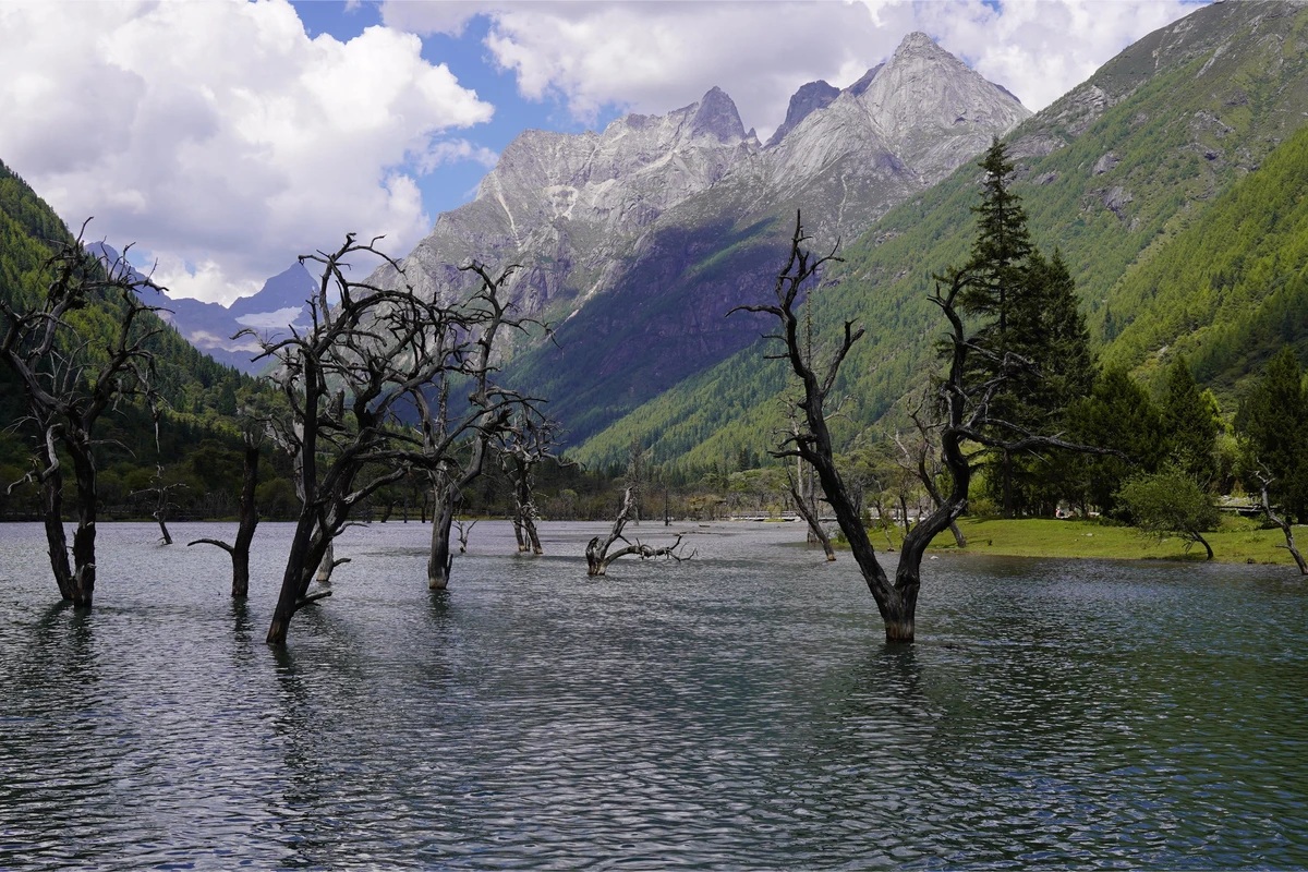
The lake water is clear, dead trees stand still, snow peaks and strange rocks are reflected, surrounded by trees and grass.
Image: Clear lake water, still dead trees, reflection of snow peaks and rocks, surrounded by trees and grass.
We walked along the wooden boardwalk around the lake; the scenery was beautiful!
Left Siguniangcuo at 12:00.
4. A 3-minute bus ride from Siguniangcuo Station to Nianyu Dam Station (3.4 km).
Nianyu Dam is in Shuangqiao Valley, at an altitude of 3500 m, semi-swamp land.
In this river lives a fish endemic to the Dadu River basin: the Dadu naked split fish. This is a high-altitude cold-water fish, also called naked-scaled fish, with tender and delicious meat.
Loggers discovered the delicious naked-scaled fish and used homemade bamboo cages placed in narrow downstream sections, then beat the water upstream with sticks to drive the fish into the cages. Hence the name “Nianyu Dam” (Catching Fish Dam).
Now it's hard to see naked-scaled fish in the water.
[There are two ways to visit Nianyu Dam: rafting or walking the 2.2 km wooden boardwalk (along the rafting route) to the temporary bus stop at the end of the rafting.]
Go through a culvert under the road to the opposite side; this is the upstream boarding point for rafting. A raft carries 2 people for 90 RMB, floating 4.5 km.
Image: Nianyu Dam rafting and boardwalk route.
We chose to walk from Nianyu Dam to the end of the rafting.
The trail is a wooden boardwalk.
The scenery along this section is “original ecological.”
Image: Rafting at Nianyu Dam, a raft carrying 2 people.
From Nianyu Dam to Longzhucuo is semi-swamp land, with beautiful scenery: grass everywhere, wildflowers fragrant, small streams quietly flowing. Walking along the boardwalk through the millennium-old sea buckthorn forest, enjoying the small bridges, flowing water, and green trees, there is an indescribable feeling of “walking in a painting.”
Image: The wooden boardwalk at Nianyu Dam built among millennium-old sea buckthorn forest.
Along the way, there are also attractions like Rhino Gazing at the Moon and Penguin Beak.
Image: Rhino Gazing at the Moon, Penguin Beak.
We had lunch at a rest pavilion along the way, with self-heating rice, yogurt, and fruit...
Three groups of yaks passed by on the grass outside the pavilion.
Image: Alpine meadow.
We walked for 2 hours.
Walk 200 meters from the end of the rafting to a temporary stop on the tourism road. This is 3.4 km from Longzhucuo.
Arrived at Longzhucuo (Bonsai Beach) at 2:30 PM.
5. One of the most beautiful spots in Shuangqiao Valley: Longzhucuo.
Longzhucuo is at 3490 m altitude.
Bonsai Beach is about 1.5 km long and tens of meters wide, with Pearl Beach in the middle.
It gets its name from the dead sea buckthorn trees in the stream. Hundreds of ancient sea buckthorn trees stand dead but unbent, some twisted, some leaning, graceful, forming a unique landscape in Shuangqiao Valley's fantasy world.
At the foot of the sea buckthorn trees, there is a clear stream; above, white clouds and blue sky; surrounded by snow mountains and grasslands, all together form a natural bonsai picture, hence the name “Bonsai Beach.”
Image: Dead sea buckthorn trees in the stream.
Image: Ancient sea buckthorn trees stand dead but unbent, some twisted, some leaning, graceful.
Image: Bonsai Beach.
Image: Bonsai Beach.
Image: At the foot of the sea buckthorn trees, clear stream; above, white clouds and blue sky; surrounded by snow mountains and grasslands.
We walked several hundred meters along the wooden boardwalk.
From different angles, the scenery constantly changed.
Image: From different angles, the scenery constantly changes.
We spent 40 minutes here.
6. Boarded the bus at Longzhucuo and went about 1 km to Cloud Mountain Language Service Center.
All sightseeing buses must drop passengers at the Cloud Mountain Language Service Center.
After getting off, visitors walk through the center and then go to the boarding station for the next stop.
The service center is built in the woods. First, there is a dining area with several stalls selling snacks and drinks.
Then enter a large building (science popularization area) with several exhibition halls worth seeing.
After walking through a small grove, you will see the bus boarding station.
7. Renshenguo Ping.
From Longzhucuo Station (Bonsai Beach) along the tourism road to Renshenguo Ping Station: 8.1 km, 14 minutes (according to Gaode map).
Arrived at Renshenguo Ping Station at 4:00 PM.
Image: Renshenguo Ping.
Renshenguo Ping gets its name from a precious rosaceous ground-stem plant called “goose cinquefoil,” which Tibetan locals call “ginseng fruit.”
Renshenguo Ping is at 3300 m, the end of the glacier landform in Shuangqiao Valley. Outside the road, there are hundreds of acres of meadows with many herds of yaks.
On the way from the service center to Renshenguo Ping, we saw many yaks on the grass to the left (west) of the bus, about 1 km from Renshenguo Ping.
Many young people walked back to see the yaks.
We felt a bit tired and it was still high altitude, so we didn't go to see the yaks.
We spent half an hour sightseeing here.
Shuangqiao Valley sightseeing bus operating hours: 7:30–18:00.
Must keep track of time.
The main scenic area of Shuangqiao Valley is at altitudes between 3840 m and 3300 m.
8. Left Renshenguo Ping Station at 5:30 PM, took the bus to the entrance of Shuangqiao Valley (South Gate).
From Renshenguo Ping Station to the entrance parking lot: 10.4 km, 16 minutes.
Along the 10 km from Renshenguo Ping Station to the entrance, you pass scenic spots like Five-Color Mountain, Sun-Moon Mirror, Three Pot Mountains, Yin-Yang Valley (buses do not stop).
Arrived at the entrance at 6:00 PM.
This is the best time to photograph the Shuangqiao Valley entrance.
Image: Shuangqiao Valley Scenic Area entrance.
Shuangqiao Valley gathers almost all the beautiful scenes of a high-altitude scenic area: majestic snow mountains, vast meadows, babbling streams, continuous green mountains, and changing clouds – an extraordinary spectacle.
We really wished we could spend another day, so we could re-enter Shuangqiao Valley the next day, focusing on the area around Siguniangcuo, Nianyu Dam, Longzhucuo, and Cloud Mountain Language Service Center.
(The distance between Siguniangcuo Station, Nianyu Dam Station, and Longzhucuo Station totals 6.8 km.)
Still stayed at the guesthouse at night.
D8 (Day 7): Shuangqiao Valley Scenic Area—Cat Nose Ridge—Wenchuan Special Tourist Area—Dujiangyan City (Overnight)
Panda Garden Wenchuan Special Tourist Area.
Tonight, rest in Dujiangyan, visit Panda Garden along the way, and tour the Wenchuan Special Tourist Area.
From Mount Siguniang to Dujiangyan City: 164 km, about 4+ hours drive.
Traffic route (navigate to Dujiangyan City):
* Mount Siguniang Scenic Area, via China Giant Panda Avenue, Dujiangyan-Wenchuan Expressway to Dujiangyan City: 164 km, 4+ hours, 8 traffic lights, toll 26 RMB.
1. We planned to go to Panda Garden first.
Left the guesthouse at 8:30 AM.
Traffic route to Panda Garden:
Via China Giant Panda Avenue, Balang Mountain Tunnel, China Giant Panda Avenue to Wolong China Panda Garden: 161.1 km, 3 hours 10 minutes, 8 traffic lights, toll 26 RMB.
Originally planned to stop at the “Panda Kingdom Summit” stone marker on Balang Mountain for a quick photo.
While making travel plans for western Sichuan in July, we were surprised to see an announcement: the section of road from Balang Mountain to “Balang Mountain Panda Kingdom Summit” has been closed since June 19, 2023.
So we had to give up the plan to visit “Panda Kingdom Summit.”
Soon after leaving the guesthouse, we started climbing, crossing Balang Mountain.
Balang Mountain, called Balang La in Tibetan, means “strange willow mountain.” Its altitude is 5040 m, located in the hinterland of Mount Siguniang and Wolong Nature Reserve.
Balang Mountain is only 200 km from Chengdu.
The Balang Mountain pass is over 5000 m high. In previous years, like the Duku Highway in Xinjiang, the road closes after winter snow, usually until February or March of the following year.
In September 2016, the Balang Mountain Tunnel was opened to traffic. The north-south tunnel is 8.8 km long, with the main tunnel 7954 m long, and the entrance at about 3850 m altitude.
“Panda Kingdom Summit” is east of the tunnel (left side); you can't see it if you go through the tunnel.
After exiting the Balang Mountain Tunnel, continue along G350 National Highway through the high mountains, passing “Cloud Viewing Platform” and then winding mountain roads; arrive at “Dengsheng Gully Nature Reserve,” where there are restrooms.
We stopped for a short break.
A group of goats surrounded tourists begging for food.
We tried some biscuits; the goats loved them, and a whole group surrounded us for more.
Image: Goats love biscuits.
Even after finishing, they wouldn't leave.
An interesting interlude.
Image: After finishing the biscuits, they still wouldn't leave.
Leaving Dengsheng Gully, we started descending, and the curves decreased.
A river appeared beside the national highway.
This section of G350 is also very scenic.
After descending through a large canyon, there were more houses by the roadside.
Passing Xindianzi and Wolong Town (there's a gas station), then crossing “Mozi Gully” intersection; G350 turns right (south) at “Longtan Village” and soon reaches Gengda Town.
The “Wolong China Giant Panda Garden Shenshuping Base” is northwest of Gengda Town.
Wolong Town is lively with many vehicles.
Navigated to the China Panda Garden ticket office.
The ticket office is in a courtyard on a side road.
The ticket seller told us we could drive into the scenic area.
Follow this uphill road for 2 km, enter the Panda Garden gate (no one at the gate), continue on the right road for 200 m, see a dozen cars parked on a dirt slope—this is the parking lot?
A person came to collect parking fee (10 RMB), and we confirmed this was the scenic area parking lot.
To the left of the parking lot, there is a gate where an electric cart is parked; this is the Panda Garden entrance.
Walk into the scenic area, a garden-style park.
Looking at signs, we learned there is an inner garden and an outer garden. The outer garden is a circular tree-lined path, the inner garden is the Panda Garden. Follow a concrete ramp to view pandas.
Up the slope is another S-shaped ramp.
We saw a crowd of seven or eight people in front. Approaching, we saw four giant pandas in a courtyard below.
By a stone cave, one panda sat on the ground chewing bamboo.
It grabbed a thumb-thick bamboo branch, took a few bites, perhaps found it too hard, tossed it aside, and grabbed another; maybe satisfied, it lay down and held the bamboo upright to chew.
Laughter from ahead caught our attention; two other pandas were “fighting.” First, they wrestled on a stone slide, then rolled off the slide. They kept at it, opening their mouths wide to “bite,” swatting with their paws, for a good ten minutes.
Image: Panda brothers.
Perhaps tired, both pandas walked toward the stone cave, and the four pandas gathered together...
We have seen pandas in zoos in Chengdu, Guangzhou Chimelong, etc., and we felt these pandas are the best at “acting cute”!
2. Our next plan was the Wenchuan Special Tourist Area in Aba Prefecture; to save time for visiting it, we only stayed briefly at the Giant Panda Garden.
The 5.12 Wenchuan Earthquake Yingxiu Epicenter Memorial Hall is 22.4 km from Gengda Town, about 30 minutes by car.
Wenchuan Special Tourist Area is a national 5A scenic area, a memorial and cultural-themed area specially developed after the reconstruction following the massive May 12, 2008 earthquake.
We visited Yingxiu.
From Gengda Town Passenger Center eastward, successively pass through two extra-long tunnels: Zijing Tunnel and Nanhua Tunnel. At “Shaohuoping,” turn right into Lanmo Line and drive 1.1 km. Arrived at Aba Prefecture Wenchuan Special Tourist Area around 12:30 PM.
Note: The 10.4 km Zijing Tunnel is a single-tube double-track tunnel. Driving facing opposite headlights requires extra caution.
The S303 Ying-Wo Road Nanhua Extra-Long Tunnel is about 3 km from the epicenter, 4987 m long.
Soon after the tunnel, we came to an intersection with three roads: left, middle, right; the left is a tunnel.
Traffic police stopped our car, checked our documents, and asked where we were going. They pointed to the middle road.
After crossing the intersection, we saw a sign for “Wenchuan Special Tourist Area Visitor Center Parking Lot.”
The visitor center is the starting point of the Wenchuan Special Tourist Area (parking fee 10 RMB per vehicle). Visitors can take an electric cart to the earthquake ruins at the middle school, 20 RMB per person (sometimes cars are not allowed into the Aba Prefecture Wenchuan Special Tourist Area).
We navigated to the first destination: the Ruins of Sichuan Wenchuan Great Earthquake Xuankou Middle School.
The ruins are about a hundred meters east of the town government.
At a fork, the navigation guided us to cross a bridge and turn left into a construction site (road widening), then saw a parking lot sign next to a pedestrian overpass. The security guard at the entrance let us drive up a ramp; at the end of the ramp was a parking lot (later we learned it was the parking lot for the “5.12 Wenchuan Great Earthquake Yingxiu Epicenter Memorial Hall”).
We left the parking lot, crossed the pedestrian bridge, and asked a stall owner on the bridge. The owner pointed to a group of collapsed buildings and told us that was the Xuankou Middle School ruins.
It was about 2:00 PM.
In front of the Xuankou Middle School ruins is a square.
We walked to the left side of the square but couldn't find the entrance. A helpful stall owner told us the entrance was at the far right end of the square.
Aba Prefecture Wenchuan Special Tourist Area, 5A.
Address: Within Wenchuan County, Aba Tibetan and Qiang Autonomous Prefecture.
Yingxiu Town is located in the southeastern part of Wenchuan County. It is the gateway from the Western Sichuan Plain into Aba Prefecture, and a必经之地 to the World Natural Heritage sites of Jiuzhaigou and Huanglong, and the Wolong-Mount Siguniang Giant Panda Habitat. It is a convergence point of Tibetan, Qiang, Hui, and Han ethnic groups, known as the “Western Qiang Gateway.”
Yingxiu Town was the epicenter of the “5.12 Wenchuan Earthquake” and suffered severe damage.
The town still preserves the original earthquake site, including the epicenter point and Xuankou Middle School, and a newly built “5.12 Wenchuan Great Earthquake Epicenter Memorial Hall” to commemorate that tragic moment. Free admission.
On May 12, 2008, a magnitude 8.0 earthquake struck Yingxiu Town, Wenchuan County, Aba Prefecture, causing heavy casualties.
Xuankou Middle School was one of the schools hardest hit by the earthquake, with 55 students, faculty, and family members losing their lives. The ruins of Xuankou Middle School have become an iconic site of the “5.12” Wenchuan Great Earthquake epicenter.
Image: The ruins of Xuankou Middle School have become an iconic site of the “5.12” Wenchuan Great Earthquake.
Entering the gate of the Sichuan Wenchuan Great Earthquake Xuankou Middle School ruins, we saw a clock model on the steps frozen at 2008-05-12 17:13.
Image: A clock model on the steps frozen at 2008-05-12 17:13.
Follow the signs counterclockwise to tour the Xuankou Middle School ruins.
During the Wenchuan 5.12 earthquake, many buildings lost their first and second floors.
Image: During the Wenchuan 5.12 earthquake, many buildings lost their first and second floors.
Among the ruins, one building stood proudly, covered with cracks but still upright.
The quality of construction is truly critical.
Visitors observed quietly, only the tour guides softly recounted the tragic history...
Leaving the Xuankou Middle School ruins, we crossed the pedestrian bridge again and followed signs uphill. The slope was steep.
At the top of the slope, we saw a stone tablet for the 5.12 Wenchuan Great Earthquake Yingxiu Epicenter Memorial Hall. Reading the text, we learned this area is a cemetery.
Midway up the slope, a small path leads to the parking lot where we had parked.
Wenchuan County lies along the Min River, distributed in a north-south strip along the river.
Wenchuan County is under the jurisdiction of Aba Tibetan and Qiang Autonomous Prefecture, located in the northwestern part of Sichuan Province. As of May 2023, the county covers an area of 4,084 square kilometers. As of the end of 2022, the registered population was 84,668.
Wenchuan County is named after the Min River (anciently called Wenshui), with a county history of over two thousand years.
Now, Wenchuan County has been completely rebuilt. When you arrive, a brand new, beautiful city appears before you.
The altitude of Yingxiu, Wenchuan, is 892 m, so there is no altitude sickness here.
Left Yingxiu at 4:00 PM for the hotel in Dujiangyan City.
Dujiangyan City is southeast of the Wenchuan Special Tourist Area.
From Wenchuan County (5.12) via Longxi Tunnel, G4217 Rongchang Expressway, Guanjiang Street to the hotel in Dujiangyan: 24 km, 1 hour, toll 17 RMB, 7 traffic lights.
Along the way, the Miaoziping Bridge crosses the Zipingpu Reservoir.
Arrived in Dujiangyan City around 5:00 PM.
Checked in and asked the front desk for the nearest courier company.
Within ten minutes, the courier arrived. Fast!
We sent the thick down jackets and pants we brought back home by courier (won't need thick clothes for the Chongqing trip).
(Today's drive: 205 km, driving 4.5+ hours.)
D9 (Day 8) (Friday): Dujiangyan City—Dujiangyan Scenic Area—Tianfu Airport—Jianyang High-Speed Rail Station—Chongqing (Overnight)
Dujiangyan Scenic Area can be roughly divided into the following parts: 1. Lidui Park (including Fuguang Temple); 2. Dujiangyan Water Conservancy Project (Fish Mouth, Jingang Dyke, Feishayan, Baopingkou); 3. Erwang Temple Ancient Building Complex (including suspension bridge, Qinyan Tower); 4. Yulei Mountain Park (including Yulei Pass, West Pass, Ancient City Wall, Yulei Pavilion, Douxi Terrace); 5. City God Temple Complex.
Today's itinerary is very full: visit Dujiangyan Scenic Area, return the car in Chengdu, leave Chengdu for Chongqing.
Had to get up early this morning!
We planned to take a train to Chongqing from Chengdu East Station this afternoon.
Today, we planned to spend 5-6 hours visiting Dujiangyan Scenic Area.
Bring trekking poles, snacks, and water.
The Anlan Chain Bridge in Dujiangyan Scenic Area is restricted to one-way pedestrian traffic!
Dujiangyan Scenic Area, 5A.
Address: Park Road, Dujiangyan City, Chengdu.
Opening hours: March 1–November 30, 08:00-18:00 (last entry at 18:00).
[Dujiangyan Scenic Area ticket info: 80 RMB/person (package with escalator may be cheaper).
Preferential policies: Seniors aged 65 and above (with valid ID) free.
Internal transportation: Reference price: Round trip 15 RMB, one-way 10 RMB; Location: Stele Pavilion; Service range: Stele Pavilion to Fish Mouth; children must be accompanied by an adult.
Dujiangyan Scenic Area is located on the Min River mainstream in the west of Dujiangyan City. It was built around 256 BC by Li Bing, the governor of Shu Commandery of the Qin State, and his son. It is the best-preserved ancient water conservancy project in China.
The Dujiangyan Water Conservancy Project consists of three main structures: the Fish Mouth diversion dike, the Feishayan spillway, and the Baopingkou water inlet, plus auxiliary structures like Baizhang Dyke and Renzi Dyke. It divides the turbulent Min River into the outer and inner rivers; the outer river drains floodwater, and the inner river diverts water for irrigation, turning the Western Sichuan Plain into the “Land of Abundance.”]
The map of Dujiangyan Scenic Area resembles a gourd. The north is the small head of the gourd, and the south is the base.
The west side of Dujiangyan Scenic Area is the Min River.
The Dujiangyan Water Conservancy Project divides the Min River into inner and outer rivers; the west one is called “Jinma River,” and the east one is “Puyang River.”
The Qingcheng Mountain-Dujiangyan Scenic Area Visitor Center is located north of the main gate ticket office. East of the ticket office is the South Gate Square.
The main entrance of Dujiangyan Scenic Area (main gate entrance) is at Lidui Park in the south of the scenic area; there is also a new east gate entrance (Erwang Temple entrance, Qinyan Tower back gate entrance), a north gate entrance, and a total of seven entrances (some are vehicle entrances).
Most visitors choose to enter through the main gate.
Our tour route:
Lidui Park (main gate) → Fuguang Temple Baopingkou Guanlan Pavilion → Feishayan → Fish Mouth Park → Anlan Bridge → Yulei Mountain Park → Guanxian Ancient City → South Bridge → Lidui Park (main gate parking lot)
1. Drive at 8:10 AM to the main gate P1 parking lot of Dujiangyan Scenic Area (located at Lidui Park).
(There are 600 parking spaces, parking fee 10 RMB/12 hours.)
Traffic route (navigate to Dujiangyan Scenic Area P1 parking lot) (or navigate to the main gate ticket office):
From hotel via Taiping Street, Park Road to Dujiangyan Scenic Area P1 parking lot: 2.7 km, 15 minutes, 4 traffic lights (taxi about 10 RMB).
After entering the parking lot, turn right (toward ticket office) to find a parking space closer to the main gate ticket office.
(Public transport: Take [Dujiangyan Bus Route 4] from the city government, about 40 minutes.)
2. From main gate ticket office to [Fuguang Temple]
Swipe ID card to enter the scenic area (tickets pre-booked);
Remember to get a scenic area map.
Walking route: After entering the ticket office, you are in Lidui Park; walk north along the scenic path, passing through Zelkova Forest to the “Iron Sleeping Horse” attraction.
The Iron Sleeping Horse is the standard for dredging buried in the “Fengqiwo” area of the inner river, also a marker for the annual maintenance of the inner river's depth. Legend has it that Li Bing buried a stone horse under the inner river bed as the standard for dredging depth, which later evolved into the Iron Sleeping Horse.
Continue a short distance north to see “Fuguang Temple.”
Legend says that when Li Bing and his son were taming the river, they subdued the evil dragon of the Min River and locked it in the Fuguang Dragon Pool under Lidui. Later, people built a temple here to worship them; the stone statue of Li Bing here is over 1,800 years old, the earliest surviving round stone statue in China, very precious.
Enter the front hall of Fuguang Temple to see the Li Bing stone statue.
According to materials, over 2,000 years ago, water engineers represented by Li Bing, together with the hardworking and wise people of Shu, innovatively created four traditional weir techniques unique to Dujiangyan: bamboo cages, tripods, sheep pens, and dry-laid cobblestones.
Using these four weir techniques, they built the Fish Mouth, Jingang Dyke, Feishayan, etc., for water retention, diversion, flood discharge, and sand discharge...
Walk along the small path east of Fuguang Temple to the Puyang River, then go up the steps to a “Huazhou Boardwalk.” Follow the boardwalk along the Puyang River to a spot directly facing “Baopingkou.”
Next to the boardwalk, there are piles of “cage stone tripods” and “bamboo cage tripods.”
Image: Piles of “cage stone tripods” and “bamboo cage tripods” next to the boardwalk.
Go to the stone railing to admire the rapids of Baopingkou.
The stone cliff under your feet is called “Lidui,” and below it is a rocky gorge called “Baopingkou” (Bottle Mouth).
Baopingkou is the first water conservancy project when entering Dujiangyan Scenic Area, used to strictly control the flow of the inner river into the Chengdu Plain. Because it looks like the mouth of a bottle from above, it got its name, also meaning “blessing for safety.”
The Min River water is tamed upstream by the weir, flows through Fish Mouth and Jingang Dyke, and reaches Baopingkou.
The water flow at Baopingkou is relatively rapid.
Image: Dujiangyan Baopingkou.
Across the Puyang River from Baopingkou is the South Bridge Antique Street.
(To visit the South Bridge Antique Street, you need to leave through the South Gate of the park, cross the South Bridge, and turn left.)
The best spot to overlook Baopingkou is the top floor of Fuguang Temple.
Walk to the end of the “Huazhou Boardwalk,” then follow the stone steps up to “Guanlan Pavilion.”
Guanlan Pavilion is on the right side of the main hall's back courtyard of Fuguang Temple, on a steep protruding rock corner.
Here you can enjoy the magnificent view of the surging river passing through Baopingkou.
3. Looking back at Fuguang Temple and Baopingkou from Feishayan.
Cross a rope bridge westward to enter a long strip-shaped island.
Image: Cross a rope bridge westward to enter a long strip-shaped island.
Walk north along the sightseeing path. Here is the [Sightseeing Car Stele Pavilion Station] (electric cart can go to Sightseeing Car Fish Mouth Station) (round trip 15 RMB, one way 10 RMB).
Take the sightseeing car from “Sightseeing Car Fish Mouth Station” back to “Sightseeing Car Stele Pavilion Station.”
There are many tourists visiting Dujiangyan Scenic Area every day, especially on holidays, and rides on the sightseeing car require long queues.
The distance from the main gate ticket office to the Sightseeing Car Stele Pavilion Station is 700 m.
Walk to the northernmost point of the island between the Puyang River and Jinma River.
At the northernmost point of the island, there is a “Feishayan” landscape.
Image: Feishayan.
The Dujiangyan water control pivot consists mainly of three major structures: Fish Mouth, Feishayan, and Baopingkou.
There are many tourists here because Feishayan is the best spot to photograph Baopingkou and Guanlan Pavilion (Guanlan Pavilion is southeast of Feishayan, with the Puyang River in between).
The Feishayan spillway, also called the “flood discharge channel,” is the second largest main structure in the Dujiangyan water conservancy project. Through clever design, it can discharge floods, divert water, and also has a strong function of draining sand and stones, expelling sand that flows into the inner river.
Feishayan looks very ordinary, but its function is enormous.
Image: Feishayan.
Image: View of Guanlan Pavilion and Baopingkou from Feishayan.
4. Fish Mouth viewing.
There are two ways to reach Fish Mouth:
1. Take the sightseeing car from [Sightseeing Car Stele Pavilion Station] to [Sightseeing Car Fish Mouth Station].
The sightseeing car leaves the Stele Pavilion Station, goes straight across the stone bridge over the Puyang River, enters the Fish Mouth diversion dike, and goes north from Renzi Dyke to the northernmost end of the Fish Mouth diversion dike.
2. Walk. The distance from Stele Pavilion Station to Fish Mouth Station is 1 km (15 minutes).
We chose to walk.
Cross the stone bridge; ahead is a small forest.
Image: There is a small forest on Renzi Dyke.
Fish Mouth diversion dike: “Fish Mouth” is the diversion project of Dujiangyan. Named for its fish mouth shape, it stands in the middle of the Min River, dividing it into inner and outer rivers. The west side is the outer river, commonly called “Jinma River,” the main stream of the Min River, mainly for flood discharge; the east side along the mountain foot is the inner river, a man-made diversion channel, mainly for irrigation.
5. Visit Anlan Bridge.
The suspension bridge near Fish Mouth is “Anlan Bridge.”
Image: Anlan Bridge.
Anlan Bridge is one of China's five famous ancient bridges, spanning the division point of the inner and outer rivers. Under the ancient Anlan suspension bridge, the river rushes.
When we crossed the Anlan suspension bridge, we saw the water was very shallow, perhaps due to drought.
The bridge was a bit wobbly, maybe because of the many tourists crossing. The bridge has railings on both sides, very safe.
In the middle of the bridge, there is a plaque reading “Couple Bridge.”
Anlan Bridge was built by He Xiande and his wife, so it is also called “Couple Bridge” or “He Gong Mu Bridge.”
Anlan Bridge consists of three sections from Fish Mouth Park to the east end; about 220 meters long.
After crossing Anlan Bridge, you can see Erwang Temple; Qinyan Tower is at a higher point of Erwang Temple.
Image: Qinyan Tower.
Reach the east end of Anlan Bridge. This is the exit of the scenic area.
We had received a notice from the scenic area's official account: The Anlan Bridge in Lidui Park is one-way (exit only).
Now we see: At the east end, there are two gates on left and right. Exiting through the right gate leaves the scenic area; however, if you want to re-enter the Dujiangyan Scenic Area, you can turn back and re-enter Anlan Bridge through the left gate, returning along the original path to the main gate.
At the east end of Anlan Bridge, 100 meters north, there is a tourist shuttle line from the north gate to the south gate of the scenic area, 10 RMB per person.
It was 11:00 AM.
Image: Notice board at the east end of Anlan Bridge.
6. Yulei Mountain Park.
Saw a notice board at the bridge end: Walk south for 25 minutes to reach South Bridge.
Checked the map and saw that the road along the river to South Bridge is very flat.
We decided to take this unfamiliar road.
Looking back at Anlan Chain Bridge from the riverbank, the scenery was even more beautiful.
After walking a hundred meters, it became an uphill path, and we realized this was the Songmao Ancient Road that goes over Yulei Mountain.
Although Yulei Mountain is not very high, climbing a long slope on the mountain road made us sweat.
Image: Looking back at Anlan Chain Bridge from the riverbank, the scenery is even more beautiful.
Passing Yulei Pass, West Pass, Ancient City Wall, Yulei Pavilion... we started descending.
Image: Songmao Ancient Road.
The road signs along the way were not very clear, but the scenery was okay. Mainly we were in a hurry and couldn't appreciate it leisurely.
7. Guanxian Ancient City.
Finally reached Guanxian Ancient City.
The ancient city is very clean.
We had lunch at a small shop.
Walking west along an east-west street, the area became lively, with small shops lining the street.
After crossing South Bridge, the parking lot was not far.
[Note: If there are no traffic restrictions in Dujiangyan Scenic Area, planning a route from Qinyan Tower to Lidui Park main gate goes from high to low, which is easier, and you can also climb to the top floor of Qinyan Tower to overlook the panoramic view of Dujiangyan.]
Left Dujiangyan City at 1:45 PM and drove to Chengdu East Station (refuel on the way).
Chengdu's Friday traffic restriction bans vehicles with license plate numbers ending in “5” and “0” from entering Chengdu.
Traffic route to Chengdu East Station:
From Dujiangyan Scenic Area via Chengguan Expressway, Second Ring Expressway to Chengdu East Station: 72 km, 2 hours, 17 traffic lights, toll 41 RMB.
On the Chengguan Expressway from Dujiangyan to Chengdu, there are no gas stations in sight; after entering the Second Ring Expressway in Chengdu, many sections were heavily congested, stop-and-go.
We had to refuel. About 20 km from Chengdu East Station, we exited the expressway to find a gas station.
Then followed the navigation again to East Station.
The last tens of kilometers in the city took over an hour.
Finally, at 3:40 PM, we saw the destination: a building opposite Chengdu East Station. We returned the car in the underground parking lot of this building.
This building is new; the second basement floor had almost no shops open, and the first basement floor had fewer than ten shops, mostly restaurants.
We had eaten some dried fruit and snacks on the way, and in this building, we ordered a bowl of soup noodles.
Our plan was to first go to Chongqing on the return trip. Returning the car at Chengdu East Station (different location) was much easier than returning at Chengdu Tianfu Airport and then taking the subway to Chengdu East Station (cross-location fee 190 RMB).
Our plan: stay in Chongqing tonight, and arrange to visit Wulong Scenic Area and enjoy Chongqing's night view.
There are frequent trains from Chengdu East to Chongqing, including to Chongqing West and Chongqing North (intercity).
We chose the following high-speed train to Chongqing:
G8731 Chengdu East (departure) 17:25—Chongqing North (arrival) 19:14 (1h49m) (second class 161 RMB).
Reminder: Although trains from Chengdu East to Chongqing are frequent, you generally cannot buy a ticket on the same day; you must book in advance.
We were worried about heavy traffic from Dujiangyan to Chengdu, so we booked a later train. We waited at Chengdu East Station for over an hour.
(Today's drive: 75 km, driving 2 hours 10 minutes.)
Western Sichuan 9-day self-drive tour: We visited 2 national 5A scenic spots (Aba Prefecture Wenchuan Special Tourist Area, Dujiangyan Scenic Area) and 5 national 4A scenic spots (Luding Bridge, Mugecuo Scenic Area, Moxi Stone Park, Jiaju Tibetan Village, Mount Siguniang Scenic Area); also visited “Ten-Mile Gallery Xinduqiao,” “Little Jokhang Temple” Tagong Temple, and gazed at Yala Snow Mountain, one of the Four Sacred Mountains of Tibet.
[Round trip from Chengdu to Western Sichuan in 9 days, total mileage 1100 km (1074), driving 30 hours.]
If you go to Sichuan without visiting Western Sichuan, it's like you haven't been there. Words cannot fully describe the beauty of Western Sichuan; only by going yourself can you experience those unique, magnificent landscapes.


