20 Days, 20,000 Miles Self-Drive Tour of Tibet (Part 7) — Holy Elephant天门 ~ Qinghai-Tibet Highway ~ Hoh Xil ~ Kunlun Mountains
1. 20 Days, 20,000 Miles Self-Drive Tour of Tibet (Part 1) — Erlang Mountain ~ Zheduo Mountain ~ Kangba Grassland ~ Haizi Mountain
https://you.ctrip.com/TravelSite/Member/EditNewTravel?travelId=3906854
2. 20 Days, 20,000 Miles Self-Drive Tour of Tibet (Part 2) — Haitong Gully ~ Dongda Mountain ~ Nu River 72 Bends ~ Ranwu Lake ~ Laigu Glacier
https://you.ctrip.com/TravelSite/Member/EditNewTravel?travelId=3931054
3. 20 Days, 20,000 Miles Self-Drive Tour of Tibet (Part 3) — Tongmai Bridge ~ Yigong Lake ~ Lulang ~ Xiuba Ancient Castle ~ Basong Tso
https://you.ctrip.com/TravelSite/Member/EditNewTravel?travelId=3931154
4. 20 Days, 20,000 Miles Self-Drive Tour of Tibet (Part 4) — Potala Palace ~ Jokhang Temple ~ Barkhor Street ~ Ramoche Temple
https://you.ctrip.com/TravelSite/Member/EditNewTravel?travelId=3938457
5. 20 Days, 20,000 Miles Self-Drive Tour of Tibet (Part 5) — Yamdrok Yumtso ~ Zongshan Ancient Fort ~ Tashilhunpo Monastery ~ Mount Everest
https://you.ctrip.com/TravelSite/Member/EditNewTravel?travelId=3931284
6. 20 Days, 20,000 Miles Self-Drive Tour of Tibet (Part 6) — Sakya Monastery ~ Shalu Monastery ~ Yangbajain ~ Namtso ~ Moon Bay
https://you.ctrip.com/TravelSite/Member/EditNewTravel?travelId=3931299
——————————————————————————————————————————————
[Contents of This Chapter]:
D15: Namtso Holy Elephant Gate — Baingoin — Amdo Yanshiping
D16: Amdo Yanshiping — Golmud
——————————————————————————————————————————————
D15: Namtso Holy Elephant Gate — Baingoin — Amdo Yanshiping
Distance: 608km, 8:30-20:30 Fuel: 270 Dinner: 85 Accommodation: Fulin Hotel 150 Ticket: 160
In the tent, there was a stove. In the first half of the night, the coal was fully added, burning fiercely, making it too hot; by dawn, the coal decreased and it quickly cooled... Eight people, mixed gender, slept in their clothes. It reminded me of the cabins on a Yangtze River passenger ship over thirty years ago. Travel experiences became the theme of a pillow talk. Besides the two of us driving, the other six had all reached Lhasa by various means and then joined tours. After a four-day itinerary, they would return to Lhasa and go their separate ways. Among them was a cyclist who said the most dangerous part of the journey was going downhill on mountain roads, losing control could cause a crash... On the Haitong Gully section, he often had to carry his bike over rough patches...
Lying in bed, one quilt felt cold, two quilts too hot... Tossing and turning, at 3 AM I got up and went back to the car, unzipped a sleeping bag and covered myself. Looking at the camp lights shining coldly in the dark night, I actually dozed off a bit, then woke up frozen. Looking outside, I saw snowflakes had quietly fallen again...
In the morning at the camp, the ground was thinly frozen. Next to the RV was a breakfast supply point: each person got a bowl of porridge or milk, a steamed bun and an egg. Everyone stood around and ate quickly. Then they started the vehicles to warm up for a few minutes and set off one by one.
The experience in this tent hotel is vastly different from Everest Base Camp — even though the altitude there was higher, I slept much more soundly.
Moon Bay, Three Holy Stones, quietly waiting for the sun to rise
At half past eight, stepping on the thin ice, we set off
Walking from the camp up the hill, there was a barrier at the intersection. In a tent beside it, two female staff sold tickets. 80 yuan per person.
The sun was still hiding behind the clouds — reluctant to come out
The mountain road leading to the Holy Elephant Gate was covered with snow and ice
Turn on four-wheel drive, drive carefully to avoid slipping
Fortunately — it was like this!
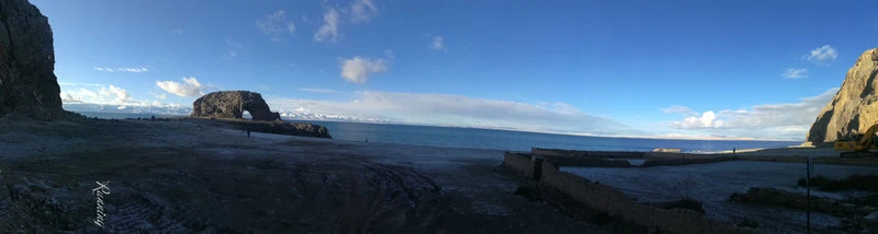
The legendary "Holy Elephant Gate" — revealed in full glory!
Construction was still going on here
Sunlight began to shine on the holy elephant
The lake reflected the sky, a deep blue
Took a photo of myself
Nianqing Tanggula Snow Mountain glowed under the morning sun
Another "Mani pile" by my husband
This is Mother Elephant, looking for her children? — On the way here yesterday, we saw two little elephants hiding at the foot of the mountain
Hard work, great Prado, bumping all the way to make our dream come true
The Holy Elephant Gate is hidden deep here — after many hardships, we finally see its true face
Left the Holy Elephant Gate around 9:30 and started the return journey.
Repeated a section of yesterday's road — along the lake, bumping all the way and snapping photos~
Clouds and snow shimmered brilliantly
Namtso — smooth as silk
The mountains seemed lightly made up, dusted with a thin layer of powder
The navigation suggested turning left towards Baingoin — no road sign, but seeing people ahead, we stopped to ask
The villagers were very enthusiastic, immediately pointing the way while talking and walking — Thank you!
After turning left, go straight into the village, then turn right towards Baingoin
This is a river! — Drive through it
On the vast snowy plain, there was only our car, enjoying the vastness of heaven and earth alone.
Here, we saw a large group of companions
A village ahead, this is the only way in — a ditch? Looking around, there were various puddles hidden in the grass, depth unknown.
Better just drive through the water!
Pit after pit — it seems small cars can't go on this road at all
Jiagang Village — there are community fitness facilities here too
There was a barrier on the road ahead, so we got out and asked. A village official on duty came out and asked us to register. My husband went to the office with his ID, registered, came out, and everyone chatted and laughed. My husband praised the beautiful scenery here! The village officials warmly opened the barrier for us.
— Some roads, you may only walk once in a lifetime; some people, you may only meet once in a lifetime.
Behind the village, there was a fence marking the pasture boundary. We got out ourselves, opened and closed the gate.
Sky full of blue, ground dotted with blue
The road looked as if it had been plowed, then frozen again
Quietly appearing at the foot of the snowy mountain
A thin red line extended towards the white clouds in front of the mountain
Far away, another sapphire
Fallen deep among the white clouds
This section of mountain road had slopes crumbling like slag
"With a path in the heart, one can reach the world" — I last saw this sentence on the way to Yigong Lake, thousands of kilometers away.
After passing through this gate ahead, turn left
WOW! Finally saw asphalt road!
A pool of water on the lakeside grassland reflected the white clouds and blue sky
On the grassland, the cows here lined up
The newly paved road ends here
"Accidents are irreversible, life does not come again" — a reasonable reminder!
Ha, there is newly paved road here! Looks like construction is in sections — deep ditches dug on the hillside, are they for flood drainage when snow melts?
Speeding along — Han Hong's song echoed in my ears — "Cattle and sheep cover the hillside..."
Kowtowing towards Lhasa — the power of piety
They are installing guardrails here
Baingoin, go straight
"Poison Thunder Bridge"! — What a name!
Here — yellow lane dividers appear!
Left to Baingoin 20.8 km; Right to Nagqu 208 km
Heading to Baingoin, turn left
This one is afraid of cold — wearing a black coat?
A line of large trucks came out — almost there?
Inspection station — when we passed, the person checking documents heard we were going to Golmud and said we were on the wrong road. We didn't need to go through Baingoin county town; at a fork ahead, go towards Nagqu, then take National Highway 109 towards Golmud.
Since we were here, let's refuel and go
Then immediately turned back.
In that short moment of turning, the clouds at the horizon began to thicken.
Speed limit is only 30
Because "accidents are frequent" here — there was a police car ahead parked as a warning
It started snowing... Just a moment ago it was clear sky and bright sun, but in less than an hour, it changed completely! The curtain fell too fast!
Rushing towards the vast unknown, a glimmer of light quietly appeared at the horizon
Opened a little more — who is peeking at the earth?
Even managed to show a bit of blue light
Who is driving a sports car in the sky?
Getting brighter — is it raining or snowing heavily on the right?
It felt like watching a dome movie
Water reflecting the sky, still one color
In the distance, clouds were falling wildly...
Throughout this plateau, birds are truly rare animals
No matter how dark the sky, we pushed straight ahead
More than twenty minutes later, we entered the snow area again
Sheep in the snow, calm and unhurried, gathered on both sides of the road
Amidst the swirling snow, this yellow wall was strikingly conspicuous
The whole world was gray and white
The sky and earth were indistinguishable
Fortunately, there were tire tracks ahead
Is the snow lighter here? The grassy slope by the road was still yellow
Here, the snow was heavy again
The car ahead vanished from sight
The snow fell heavier and heavier
Wiping the windshield, we saw a large truck ahead!
At turns, we had to go very slowly and honk — downhill slippery, large trucks easily lose braking power
Yaks in the snow had become black dots
Black and white landscape sketch
Like random daubs on reserved white space — faintly visible snowy slopes
Leaving the heavy snow area, small snowflakes still drifted
Ahead on today's itinerary, there was the famous Tanggula Mountain to cross. Looking at the swirling snow now, I didn't know the road conditions ahead.
At the inspection station, we asked the staff. Based on his experience, he suggested crossing the mountain today, because if the snow freezes tonight, the mountain road might be very slippery tomorrow... I recalled the experience of crossing Zheduo Mountain... We decided to cross!
A very long convoy of big trucks came... Was it because the snow ahead had caused a blockage?
The snow seemed to lighten a bit
The horizon turned blue again~
Then the world turned into a watercolor painting
These red guardrails are striking!
Guess what this is?
There is also single-sided ones
【The Qinghai-Tibet Plateau has permafrost distributed at high altitudes, divided into two layers: the upper active layer which thaws in summer and freezes in winter, and the lower permanently frozen layer. The annual average temperature at the lower limit of permafrost is about –3.5° to –2°C. Repeated freeze-thaw of the active permafrost layer and incomplete winter freezing can endanger roadbeds.
The Qinghai-Tibet Railway builders creatively proposed a new idea of "actively cooling, cooling the roadbed, and protecting permafrost," and adopted new technologies such as thermosiphons.
The above-ground part of the thermosiphon is the condensation section, and the underground part is the evaporation section. When the temperature of the condensation section is lower than that of the evaporation section, the liquid substance in the evaporation section vaporizes and rises, then cools and becomes liquid in the condensation section, returning to the evaporation section, circulating repeatedly.】
This technology is also used in the roadbed of certain sections of the Qinghai-Tibet Highway.
Here, the snow stopped.
The sky cleared, and the snow-covered plateau revealed its beauty.
The snow-clad earth embraced the blue sky fringed with white clouds.
Who got mesmerized by the beautiful scenery here?
Tuojula Mountain, elevation 5170 meters.
For someone living by the sea, such altitude makes one feel "the earth is in the sky."
Clouds on the ground...
High sky, high clouds, high land.
This round lake reminds me of the "Grand Prismatic Spring" in Yellowstone National Park (see details: East and West USA Self-Drive Tour - 21 Days Free Travel (6) Yellowstone National Park http://you.ctrip.com/travels/yellowstonenationalpark120415/3053752.html)
Of course — this is a world of ice and snow, while that one is steaming hot.
Both round, as if "the eye of the earth."
Here, small lakes connect into a chain.
Another single-sided thermosiphon.
On the road surface, cracks from thermal expansion and contraction form a grid pattern.
Clouds, sky, snow peaks — harmonious together.
The iron tower standing on the snowy mountain is truly beautiful!
The famous Tanggula Pass, we've arrived!
Qinghai-Tibet Power Grid Interconnection Project Monument.
Power Grid Interconnection Project Description (How are those who scribbled their names doing now?).
Bright Heavenly Road, Tanggula Pass, 5231 meters.
In the western sky, we saw a rainbow!
Lhasa Communication Engineering Monument.
White hada shows true feelings.
["Tanggula" means "mountain on the plateau" in Tibetan. Due to year-round wind and snow, it is called the "snow storage." Tanggula is the dividing line between Qinghai and Tibet. At an altitude of 5231 meters, there is a monument and marker at the pass. It is a must-pass on the Qinghai-Tibet Highway to enter Tibet and the source of the Yangtze River. It is the highest highway in the world. The main peak of Tanggula, Geladandong, is over 6000 meters, the source of the Yangtze River. The weather at the pass is extremely unstable. Even in summer, the highway is often blocked by heavy snow, with hail and frost common. The oxygen content here is only 60% of sea level, so ordinary passengers passing through Tanggula Pass will experience significant altitude sickness.] — Fortunately, passing through here, we didn't feel any reaction at all.
Flashback**************************************************************************************************************************
2009: Xiao Fei crossing Tanggula Mountain.
There are sheds here — road construction?
There is actually a repaired section.
**************************************************************************************************************************88
After crossing Tanggula Pass, the wide river quietly accompanies the snowy mountains.
Is this the source of the Yangtze River?
Clouds gradually pressed down again.
Wow~ ⊙o⊙ A horse-drawn cart — on this high-altitude oxygen-deficient place, it must be very hard too.
Blue quietly fades away.
Looking at this — does it look like an elephant lying asleep here?
Approaching, looking at the roadside — an accident ahead.
Quickly passing the accident area, then looking back, clearer — a large truck overturned.
Drive carefully — safety first!
The sky gradually darkened.
The highway meets the railway.
The road is slippery, trucks are driving very slowly.
The light is getting darker.
There is a parking lot ahead.
There is still over a hundred kilometers to the planned destination, Tuotuo River, at this speed it would take several more hours.
Looking at the parking lot — we didn't stop, thinking it was only just past seven, let's drive a bit more.
The taillights of the big truck ahead are particularly conspicuous on this snowy, windy night.
Darkness fell quickly.
The direction of the road was lost in the dark — my heart also began to wander: driving for a few more hours is obviously impossible. Where ahead could we find a place to stay tonight?
Turning on high beams, looking through the windshield, snowflakes filled our vision, rushing towards us... We simply couldn't see the road... This was already wilderness, unable to stop, only to continue.
The snowflakes scraped off by the wiper blades left residue on the brush, starting to ice up; the windshield view gradually blurred. We stopped and cleaned it.
Turned off high beams, used low beams, carefully probing the road.
Finally saw a large truck ahead, we followed it; after a while, my husband habitually thought about overtaking.
Flashed the left turn signal, the truck driver unhurriedly moved to the right lane, my husband overtook on the left.
Then the truck's headlights illuminated the road, and we drove forward.
When we got beyond the range of the truck's lights, the road immediately blurred. Turning on high beams, the view was filled with flying snow; switching to low beams, everything ahead was pitch black...
Braked immediately — we looked at each other and laughed... Hahaha, better just behave—
Parked in the left lane, waited for the big truck to slowly catch up.
Then, under the pink glow of the truck's taillights, we slowly followed at 20 km/h...
On this snowy, windy night, at an altitude of 4-5 km on the Qinghai-Tibet Plateau, for the first time I felt — following behind this huge truck, watching the blinking red lights, felt so secure and warm!
Small car following big truck — like a little brother following a big brother!
Ha, did that driver brother also laugh when he saw us overtake and then stop to let him go first?
Passing a checkpoint, turning on high beams, we saw that this was also a trailer carrying off-road vehicles... Haha, truly the big brother of small cars!
After following for about 20 minutes, we saw an inn sign by the road and immediately decided to stop and rest — driving carefully in the dark with eyes wide open was just too tiring!
Pulled over to the side, this was Fulin Hotel, found a spot to park. The room was upstairs, we looked and chose a room (three-bed room, 150 yuan), then went to the restaurant downstairs to eat first. Ordered two dishes, a soup plus rice, 83 yuan. The boss asked us to pay the room and meal fees together.
The room facilities were very simple: three beds, a table opposite. The landlady brought a bottle of hot water. The public toilet was outside, basic almost to the point of being dangerous.
Fortunately, in Bangda we had bought a basin, so we could soak our feet in hot water to relieve fatigue.
There was no running water; cold water came from a thermos barrel by the restaurant door. One bottle of hot water was mostly used. Thought we would get some hot water in the morning to drink on the road.
Plugged in my phone to charge, turned on the electric blanket to warm up.
Outside it was still windy and snowy, some big trucks were still on the road — when we were eating, two truck drivers also stopped to eat. Asked them why the big trucks drive so slowly? They told us that due to water temperature control requirements, trucks cannot speed, so they drive in shifts and generally don't stop to rest.
D16: Amdo Yanshiping — Golmud
Distance: 514km 8:30-20:30 Fuel: 350 Dinner: 84 Accommodation: Hanting Hotel 152
Early in the morning, felt a bit cold, looked at the electric blanket's power light, it wasn't on; turned on the lamp, found no light — no electricity!
Lay in a daze until dawn, then got up. Went downstairs, wanted to find some hot water, but saw both front and back doors of the restaurant were closed, and couldn't find the boss's family upstairs. The thermos barrel in the corridor had no cold water either.
Great Prado, sleeping overnight in the snow — had grown ice whiskers!
The license plate was also frozen solid! No electricity, no water, even no hot water — definitely not intentional plate covering!
Those long ice icicles brought back childhood memories — when it snowed in winter, long icicles would hang from thatched roofs, and after the snow cleared, they sparkled in the sunlight under a clear sky...
Some small cars also followed the big brother here to stay overnight.
Snow on the roof of the adjacent small car — tried to fill a bottle, how much would it be? — later melted into snow water, about 5 cm?
Fortunately, there was still some hot water left from yesterday — for washing and breakfast, extremely frugal.
By the time we set off at 8:30, the boss still hadn't appeared. The guests had already paid and left on their own in the morning.
Amdo Yanshiping — there are other inns here, I wonder what they are like?
As we drove, did the clouds fall?
The sky and earth embraced again.
There were animals on the grassland — with their strong build, were they wild donkeys?
In twos and threes, heads down grazing.
Yaks grazed peacefully between the highway and railway, acting as models for tourists.
A gate rose from the flat ground — to pass through to another time and space?
"Northern Gate of Tibet, Welcome back to Tibet" — are we leaving Tibet already?
After passing the gate, are these Qinghai yaks?
【The Qinghai-Tibet Railway is a railway connecting Xining City, Qinghai Province to Lhasa City, Tibet Autonomous Region. It is one of China's four new great projects and the highest altitude, longest plateau railway in the world.
The Qinghai-Tibet Railway has a total length of 1956 km, built in two phases. Phase I from Xining to Golmud opened in May 1984; Phase II from Golmud to Lhasa opened on July 1, 2006.】
The Qinghai-Tibet Railway and the Qinghai-Tibet Highway often intersect.
【The Qinghai-Tibet Highway starts from Xining City, Qinghai Province in the east and ends at Lhasa City, Tibet in the west, with a total length of 1937 km, roadbed width of 10 meters, a national Class II highway.
It is the highest-altitude, longest asphalt highway in the world, and also the shortest, best-conditioned, and safest road to Tibet. Along the way, you can see grasslands, salt lakes, gobi, mountains, deserts, etc.】
The windward and leeward sides of the mountain slope differ greatly.
As we drove, we left the snow area again.
First Town of the Yangtze River — Tanggula Mountain Town. First Bridge of the Yangtze River — Tuotuo River Bridge.
We had already passed countless section speed checks.
Ahead was the First Town of the Yangtze River — Tanggula Mountain Town. This is where drivers stop to rest on the Qinghai-Tibet Highway. The town has many auto repair shops, inns, and restaurants.
Because we couldn't get hot water this morning, we stopped here to look for hot water. Carrying a kettle and going from shop to shop, I suddenly felt what it was like to beg — found a restaurant where the owner was making homemade braised pork hocks and trotters. Hearing my request, he specially boiled a pot of hot water for me. The young man is from Sichuan and has been running this restaurant here for several years, working alone as both boss and waiter. Talking about the weather here, it changes at a moment's notice — wind, rain, clear sky, snow, all in a day.
Filled the thermos, thanked the boss, and continued north from the town.
Passed the Tuotuo River Bridge.
This is the "First Bridge of the Yangtze River" — Tuotuo River Bridge.
Below the bridge is the source of the Yangtze River.
The Qinghai-Tibet Railway also passes through here.
Sure enough, after a short drive, it started raining again.
Iron towers, tall and unyielding.
In the distance, still wild donkeys?
The rain stopped. Looking out the window at the swiftly passing grassland — suddenly I noticed something moving?
It's Tibetan antelope!
Pulled over and watched quietly — afraid of scaring them away.
This season, the grassland is yellow, providing a perfect protective color for them.
【The Tibetan antelope is a species of antelope under the subfamily Antilopinae, a precious and rare species in China, a first-class protected animal. It resembles the Mongolian gazelle, body length 117-146 cm, tail 15-20 cm, shoulder height 75-91 cm, weight 45-60 kg. It mainly inhabits desert meadows and plateau grasslands at altitudes of 4600-6000 meters. Timid in nature, they move and graze in small groups at dawn and dusk. Tibetan antelopes are good runners, with a top speed of 80 km/h, and a lifespan of up to 8 years. Female antelopes travel long distances to give birth in Hoh Xil. They are mainly distributed on the plateaus of Xinjiang, Qinghai, and Tibet, with a few individuals in India.】
Zoomed in. See? A group of beautiful little spirits.
Ahead, the sky turned gray again.
Vast sky and boundless land.
Long road stretching to where?
In the endless snowfield, faint Tibetan antelopes.
Against the black and white backdrop, those agile figures looked especially graceful.
Quite a large herd.
Yaks remained the same, grazing head down, unfazed by wind and snow.
Here, the highway and railway run parallel.
Qinghai Hoh Xil National Nature Reserve Tuotuo River Protection Station — seems empty now.
The road was full of potholes — ice, snow, sun, thermal expansion and contraction never let the roadbed rest.
Met the big brother again.
Daytime, we dared to overtake.
Arriving here, the snow gradually stopped.
The sky curtain began to open a little.
The faint mountains seemed like simple sketches.
One must experience the vastness of heaven and earth to truly understand it.
Against the blue sky, large white clouds began to float; the brown earth, full of affection.
Many large trucks — coming downhill around bends, better slow down and let them pass.
Simple rest areas were set up by the road for vehicles to take a break.
Here, it didn't seem to be in the snow area just now.
Not a trace of snow shadow.
The water from the snowy mountains flowed quietly — merging into the Yangtze River, heading to the sea... If I folded a paper boat and set it adrift here, would it float to my hometown?
Viewing from here —
The journey home was still far.
A lake of clear water as smooth as a mirror.
Thousands of miles of snowfield in camouflage makeup.
Encountering a long convoy of trucks — had to watch for opportunities and overtake one by one; if a car came from the opposite direction, we had to quickly merge back into the truck line.
The truck drivers were also experienced, knowing small cars might need to cut into the traffic at any time, so they always maintained a safe distance from the vehicle ahead.
Scenery on both sides of the highway.
Passing through Wudaoliang — another stop for drivers to rest.
China Surrounding Petroleum — Ha! A slip of attention and you'd think it's "China Petroleum"?
The famous Hoh Xil.
Hoh Xil (Qinghai Hoh Xil National Nature Reserve) is located in Yushu Tibetan Autonomous Prefecture, Qinghai Province. It was inscribed on the World Heritage List in July 2017. The reserve lies in the western part of Yushu Prefecture, covering a high-altitude platform spanning Qinghai, Xinjiang, and Tibet. It borders Tibet to the west, Golmud Tanggula Township to the south, Xinjiang to the north, and the Qinghai-Tibet Highway to the east, with a total area of 45,000 square kilometers.
Tibetan antelope corridor bridge.
Black, white, gray — the natural protective colors of animals.
Can you see them grazing intently?
Along the way, the Qinghai-Tibet Railway accompanied us — we finally saw a train.
Speeding across the snowfield.
A person walking along the highway — could he be returning from Lhasa after prostrating? — It's too far.
Occasionally we met passersby trying to hitchhike. Our car was packed full, no empty seats.
Such a long journey, even by car it feels endless; with shifting wind, snow, and weather, walking is truly remarkable!
Saw Tibetan antelopes again —
Driving while scanning, then quietly stopped to take photos.
Tried not to let them notice — didn't want to disturb these beautiful little creatures.
That they can graze so peacefully on both sides of the highway is truly hard-won!
These houses on stilts — to avoid being buried by deep snow?
By the river, two Tibetan antelopes were grazing peacefully — the river background made them clearer.
Ahead, a golden Tibetan antelope sculpture.
Here is the Sanjiangyuan National Park, Sonam Dargye Protection Station.
A pair of long Tibetan antelope horns stretched high into the sky.
Entering the Hoh Xil Exhibition Center.
First, we saw pictures of Hoh Xil's wildlife.
Hoh Xil National Nature Reserve is one of the best-preserved original ecological environments in the world in the early 21st century, and one of the largest, highest-altitude, and richest wildlife nature reserves in China.
Qinghai Hoh Xil National Nature Reserve mainly protects Tibetan antelopes, wild yaks, Tibetan wild donkeys, Tibetan gazelles, and other rare wild animals, plants, and their habitats.
These beautiful creatures once suffered rampant poaching.
Starting in the 1980s, large numbers of gold prospectors flooded into the uninhabited area, causing gravel accumulation, river cutoffs, and mass killing of Tibetan antelopes and other wildlife...
The cold wind was filled with their mournful cries...
【Faced with the ecological crisis in Hoh Xil, Jesang Sonam Dargye, then deputy party secretary of Zhidoi County, Yushu Tibetan Autonomous Prefecture, Qinghai Province, repeatedly proposed to the county committee to protect national resources and rationally develop Hoh Xil. He promoted the establishment of the Hoh Xil Ecological Environmental Protection Agency — Zhidoi County West Work Committee, and was appointed as its secretary.
He went deep into Hoh Xil 12 times for field surveys and patrols, collecting a large amount of first-hand natural resource distribution data. He also formed China's first armed anti-poaching team and captured 8 illegal armed poaching groups.
On the night of January 18, 1994, Jesang Sonam Dargye and four team members captured 20 poachers in Hoh Xil, seized 7 vehicles and over 1800 Tibetan antelope skins. While escorting the criminals near Sun Lake, they were attacked by the criminals. Jesang Sonam Dargye confronted armed poachers in the uninhabited area, shed his last drop of blood, and was sculpted into an ice statue by the -40°C wind and snow of Hoh Xil.】
Now, along the way in the snowy fields, yaks, Tibetan antelopes, wild donkeys, etc., graze peacefully... Their leisure is hard-won!
The reserve not only has seemingly gentle and cute Tibetan antelopes, but also various fierce animals that maintain the balance of the ecosystem.
(— Just as this travelogue was about to be published, news came online that a female senior student from a Nanjing university went to Hoh Xil alone, lost contact for 22 days. On July 30, human bone tissue was found in the uninhabited area south of Qingshui River near the protection station. DNA comparison confirmed her remains... The local authorities mobilized over a hundred people to search an area of over 100 square kilometers in this unpredictable, snowy, high-altitude desert...
Hoh Xil — not only the climate challenges human life, but also wild animals! This is by no means a place for human willfulness!)
Coming out of the protection station, the sky seemed to reflect the winds and clouds of the past.
Silently bearing everything that happened.
Continuous reproduction is the best testimony.
Sanjiangyuan Nature Reserve — the Yellow River, Yangtze River, Lancang River — all originate here.
Approaching Kunlun Pass.
Kunlun Pass is 4700 meters above sea level.
This is the exit of Hoh Xil from south to north.
It's also the entrance to Hoh Xil from north to south.
Sonam Dargye's statue and monument.
Kunlun Mountains World Geopark.
[The Kunlun Mountains are also called Kunlun Xu, China's First Sacred Mountain, Ancestor of Ten Thousand Mountains, Kunlun Qiu, or Jade Mountain. It is a major mountain system in central Asia and the backbone of western China's mountain systems. Ranging from the eastern Pamirs, crossing Xinjiang and Tibet, extending into Qinghai, it is about 2500 km long, average elevation 5500-6000 meters, width 130-200 km, narrower in the west and wider in the east, total area over 500,000 square kilometers. The Kunlun Mountains hold a prominent position in Chinese cultural history as the "ancestor of ten thousand mountains" and the "ancestor of dragon veins."]
Passing through the pass, heading towards Kunlun.
"Clouds and air connect to Kunlun, the drizzling rain is abundant" — Was it like this in Du Fu's time at Kunlun?
The road certainly wasn't this good.
Nor would there be this.
Is that a small house in the distance?
[The northern slope of the Kunlun Mountains belongs to the warm temperate Tarim and Qaidam deserts, with low precipitation; as altitude increases, the warm temperate desert transitions to alpine desert, with increasing precipitation. The snow line is at 5600-5900 meters, above which is year-round glacier, with an area of over 3000 square kilometers, one of China's major glacier areas. Glacial meltwater is the source of several major rivers, including the Yangtze, Yellow River, Lancang (Mekong), Nujiang (Salween), and Tarim River.]
Qinghai-Tibet Railway bridge?
Reminiscent of the southern section of the Duku Highway?
Seeing big trucks lined up, we also stopped and waited. Then my husband went to check the situation.
Another accident ahead.
Small cars can slowly pass from the side.
Another large truck overturned by the roadside.
Crossing the Kunlun Mountains, entering the southern edge of the Qaidam Basin — last year when touring Xinjiang, we traversed the north-central part of Qaidam...
Tall iron tower — good signal here.
Entering Golmud City — last year on the way from Qinghai to Xinjiang, there was a road sign pointing to Golmud. At that time, my husband asked me, "Want to go to Golmud? Take you to Tibet?" — At that time, I had great doubts about altitude sickness in Tibet and was not at all prepared to go to the plateau.
Heading towards Golmud urban area, both sides of the road began to become lush green.
Various street trees.
Traffic in the city was considerable.
We booked a hotel on Ctrip in advance, located on the upper floor of a shopping mall. When we got there, we couldn't find parking. So we gave up.
Found a nearby Hanting chain hotel. Settled in.
Then went to a nearby Sichuan restaurant. The boss and his family of three ran the shop. Talking about our itinerary, we planned to take a new expressway tomorrow — the Dema Expressway. From online information, we knew this expressway had few gas stations and had been considering where to refuel. When the boss heard this, he immediately gave advice — it turned out they often take this expressway when returning to their hometown in Sichuan. This dinner was truly value for money!
Flashback************************************************************************************************************************
2009: After Golmud, my husband went to Xining and saw wild camels along the way.
***************************************************************************************************************************88
To be continued~~
————————————————————————————————————————————————
8. 20 Days, 20,000 Miles Self-Drive Tour of Tibet (Part 8) — Dema Expressway ~ Dongji Cuona Lake ~ Shennongjia Dajiuhu
https://you.ctrip.com/TravelSite/Member/EditNewTravel?travelId=3931262
—————————————————————————————————————————————————
Thanks for watching~~
More highlights: See the blog "Running Clouds and Flowing Water" by Running, Running at https://you.ctrip.com/members/B9B733CD98964040B907062513C0C1F0/journals
https://you.ctrip.com/travels/ningguo1167/3895133.html
Wannan Sichuan-Tibet Line Weekend Self-Drive Tour
https://you.ctrip.com/travels/china110000/3871336.html
20 Days, 20,000 Miles Self-Drive Tour of Xinjiang (Part 8) — Grassland Sky Road
https://you.ctrip.com/travels/china110000/3817602.html
20 Days, 20,000 Miles Self-Drive Tour of Xinjiang (Part 7) — Flaming Mountain ~ Thousand Buddha Caves ~ Grape Valley ~ Ejina Banner
https://you.ctrip.com/travels/china110000/3817223.html
20 Days, 20,000 Miles Self-Drive Tour of Xinjiang (Part 6) — Xinjiang Museum ~ Salt Lake City ~ Jiaohe Ruins ~ Karez Well
https://you.ctrip.com/travels/china110000/3817073.html
20 Days, 20,000 Miles Self-Drive Tour of Xinjiang (Part 5) — Yining ~ Sayram Lake ~ Anjihai Grand Canyon
https://you.ctrip.com/travels/china110000/3816041.html
20 Days, 20,000 Miles Self-Drive Tour of Xinjiang (Part 4) — Duku Highway ~ Bayanbulak ~ Nalati ~ Yining
https://you.ctrip.com/travels/china110000/3814631.html
20 Days, 20,000 Miles Self-Drive Tour of Xinjiang (Part 3) — Lop Nur Village
https://you.ctrip.com/travels/china110000/3813266.html
20 Days, 20,000 Miles Self-Drive Tour of Xinjiang (Part 2) — Water Yadan ~ Emerald Lake ~ Loulan Museum
https://you.ctrip.com/travels/china110000/3799409.html
20 Days, 20,000 Miles Self-Drive Tour of Xinjiang (Part 1) — Kumbum Monastery ~ Dankaer Ancient City ~ Qinghai Lake ~ Chaka Salt Lake ~ Haizi
https://you.ctrip.com/travels/jiangsu100066/3790498.html
Xiang Yu's Hometown - Tai'erzhuang Ancient City - Yimeng Mountain Three-Day Tour
https://you.ctrip.com/travels/auckland320/3677745.html
A Memoir of a Decade in Australia — 11-Day Tour in Melbourne, Brisbane, Auckland, Sydney
https://you.ctrip.com/travels/haikou37/3666775.html
Winter Hainan Nine-Day Self-Drive Island Tour (Part 2) — Sanya ~ Changjiang ~ Haikou
https://you.ctrip.com/travels/wanning846/3640304.html
Winter Hainan Nine-Day Self-Drive Island Tour (Part 1) — Haikou ~ Wenchang ~ Qionghai ~ Wanning ~ Lingshui ~ Wuzhishan ~ Sanya
https://you.ctrip.com/travels/sanfrancisco249/3119664.html
East and West USA Self-Drive Tour — 21-Day Free Travel (7) Yellowstone Bear World - Lake Tahoe - San Francisco - California Highway 1 - Los Angeles
https://you.ctrip.com/travels/yellowstonenationalpark120415/3053752.html
East and West USA Self-Drive Tour — 21-Day Free Travel (6) Yellowstone National Park
https://you.ctrip.com/travels/moab2091/3042422.html
East and West USA Self-Drive Tour — 21-Day Free Travel (5) Arches National Park - Salt Lake City - Grand Teton National Park
https://you.ctrip.com/travels/page33407/3038164.html
East and West USA Self-Drive Tour — 21-Day Free Travel (4) Page (Antelope Canyon) - Monument Valley - Moab
https://you.ctrip.com/travels/lasvegas252/3033571.html
East and West USA Self-Drive Tour — 21-Day Free Travel (3) Los Angeles - Las Vegas - Grand Canyon
https://you.ctrip.com/travels/washingtondc257/3022625.html
East and West USA Self-Drive Tour — 21-Day Free Travel (2) Washington D.C.
https://you.ctrip.com/travels/newyork248/3015373.html
East and West USA Self-Drive Tour — 21-Day Free Travel (1) New York
https://you.ctrip.com/travels/yanan423/2642520.html
Tracing the Footsteps of History — Xi'an Yan'an Three-Day Tour
https://you.ctrip.com/travels/ningguo1167/2639435.html
Joyful White+Black — Baishi Cliff - Heidong Waterfall Two-Day Hiking Tour
https://you.ctrip.com/travels/vestal43119/2627577.html
Early Winter Scenery of Vestal, USA
https://you.ctrip.com/travels/shengsi82/2622839.html
Shengsi Island Three-Day Self-Drive Tour
https://you.ctrip.com/travels/hawaii251/2621248.html
Gathering in Beautiful Hawaii — 14-Day Free Travel on Oahu and Big Island