Xining-Yushu-Golmud Grand Loop
Xining-Yushu-Golmud Grand Loop
Hello everyone, I am Xiao Guo, a travel guide from Na Cuo Outdoor. Having read many books written by soldiers, I was deeply moved and embarked on a spontaneous journey. In 2012, I rode a bicycle solo along the 318 Sichuan-Tibet Highway to challenge myself.
On the road, you forget your age.
On the road, you forget yesterday's troubles.
Either work or travel,
Your body and soul must be on the road.
After finishing the bike ride in 2012, I returned to Golmud and opened a guesthouse named Love Travel Guesthouse. I promoted and introduced the surrounding attractions of Golmud to guests. During the off-season, I gradually visited many popular and less-traveled routes: 318 Sichuan-Tibet Highway, 317 Northern Sichuan-Tibet Highway, 109 Qinghai-Tibet Highway, 219 Xinjiang-Tibet Highway, Tang-Tubo Ancient Road, 214, 315, and so on... Next, I will introduce a less-traveled route to you.
Self-driving in Qinghai, the most comprehensive Qinghai scenic route, this is a grand loop starting from Xining, through Yushu, Golmud, and back to Xining, covering all of Qinghai's natural landscapes. It includes all the famous attractions you've heard of, as well as those you haven't. To explore Qinghai in one go without regrets, how to plan the itinerary? Below, I will explain the daily itinerary, scenic spots, and arrangements in detail from Xining to Yushu to Golmud and back to Xining.
Day 1: Xining → Riyue Mountain → Daotang River → Gonghe County → Maduo County
Along the way, you can see the natural scenery of Riyue Mountain, also known as "Chiling," which is the dividing line between agricultural and pastoral areas in Qinghai Province. You can also see the Daotang River, whose direction was changed from west to east by crustal movements and the uplift of the Qinghai-Tibet Plateau, hence its name "Daotang River" (Reverse-flowing River).
Day 2: Maduo → Zhaling Lake → Eling Lake → Maduo
Drive from Maduo to the Cattle Head Monument at the source of the Yellow River, passing by Zhaling Lake and Eling Lake, then return to Maduo County. The total distance for the day is about 200 kilometers. The road conditions to the Cattle Head Monument are poor, so check the car's chassis and all four tires before entering the lake area. For such corrugated roads, a four-wheel-drive off-road vehicle is best. Zhaling Lake covers an area of 524 square kilometers, with a maximum depth of 13.1 meters and an average depth of 8 meters, storing 30-40 billion cubic meters of water. Its deepest points are on the north shore, and the underwater terrain is asymmetric, deep in the north and shallow in the south. Eling Lake covers an area of 608 square kilometers, with a maximum depth of 30.7 meters and an average depth of 20 meters, storing 100-120 billion cubic meters of water. The Cattle Head Monument at the source of the Yellow River is located on the top of Cuowagaze Mountain at an altitude of 4610 meters, between Eling Lake and Zhaling Lake.
Day 3: Maduo → Anyemaqen Snow Mountain → Maqin
Anyemaqen Mountain is located in Qinghai Province, China. In Tibetan, it means "strong ancestor." It is a sacred site of the ancient Tibetan Yongzhung Bon religion. The Tibetan people call Anyemaqen "Bokawajiangong," meaning one of the nine great creator gods who separated heaven and earth. Among the twenty-one sacred snowy mountains revered by Tibetans, it ranks fourth. It is known as Sibaqiaobei Lage, in charge of the rise and fall of mountains and rivers in the Amdo region and is the protector of Tibetans. Legend has it that the mountain god Anyemaqen is the fourth son of the living mountain god Wode. To save the Tibetan people from disasters and allow them to live in peace and prosperity, Wode sent his fourth son to Amdo to eliminate demons, subdue wild beasts, and punish evildoers, bringing happiness and harmony to the people. Later, when the fourth son met his father Wode Gongjia, the nine-story white jade tower they built became the Anyemaqen mountain god.
In short, there are three major soul mountains in Tibet: the upper soul mountain Gangdise, the middle soul mountain Nyenchen Tanglha, and the lower soul mountain Maqing Snow Mountain. To represent the non-illusory origin, three holy lakes are consorts of these mountains: Mapam Yumco, Namtso, and Qinghai Lake. As the ancients said: "The upper has the retinue of Gangdise, the middle has the retinue of Nyenchen Tanglha, and the lower has the retinue of Maqing Snow Mountain."
Day 4: Maqin → Lari Monastery → Yushu
Lari Monastery is located on the east side of Kemeigoukou in Dawu Town. It is a Gelugpa Tibetan Buddhist monastery. Its main buildings consist of three prayer halls: the Hall of Logic, the Hall of Esoteric Buddhism, and the Hall of Eighty Mahasiddhas of India. There are 21 large and small prayer wheels, 111 large and small stupas, four walls of stone-carved scriptures, and prayer flags covering about 80 mu of land. During major Buddhist events, thousands of devotees and monks come to worship, creating a grand scene.
Day 5: Yushu → Tongtian River → Sunning Sutra Platform → Xinzhai Gyanai Mani Stone City → Yushu Earthquake Ruins → Princess Wencheng Temple → Yushu Museum
The Tongtian River is the main stream section of the Yangtze River's source. It is located within Yushu Tibetan Autonomous Prefecture in Qinghai Province. Starting from the confluence of the Dangqu (true source of the Yangtze) and the Tuotuo River (western source) at Nangjibalong in the western part of Zhiduo County, it flows through Zhiduo, Qumarleb, Chindu counties, and Yushu City, ending at the Batang River estuary in Jiegu Town, Yushu City. Below this point, it is called the Jinsha River.
Xinzhai Mani Stone Mound is located in Xinzhai Village, Jiegu Town, the seat of Yushu Tibetan Autonomous Prefecture in Qinghai Province, at an altitude of over 3600 meters. It has a history of 300 years. The magnificent Mani mound is the largest of its kind in the world, known as "the world's largest place for blessing and making wishes." It contains tens of billions of individual Mani stones. The Gyanai Mani stones were once praised as "comparable to the holy city Lhasa" and are famous in the "Han, Tibetan, and Hor regions." The total number of Mani stones reaches 2.5 billion.
Princess Wencheng Temple, also known as "Garsa Princess Temple," is said to have been built by Tibetan people in the Tang Dynasty to commemorate Princess Wencheng. It is located in Yushu Tibetan Autonomous Prefecture, Qinghai Province, in the "Source of Three Rivers" area on the southeastern Qinghai-Tibet Plateau. Built in the Tang Dynasty, it has a history of over 1300 years and is an important cultural relic of the Tang-Tubo Ancient Road. It is a provincial-level key cultural relic protection unit in Qinghai and has been listed as a national-level cultural relic protection unit.
If you have extra time, you can add two days in Yushu to visit Nangqian Gari Monastery, the Lancang River, and other attractions. Yushu's natural scenery is very beautiful, so be sure to enjoy it thoroughly.
Day 6: Yushu → Longbao Wetland Park → Gado Juewu Sacred Mountain → Qumarleb
Yushu Longbao National Nature Reserve covers an area of 10,000 hectares. Its meadows and freshwater swamps provide a good ecological environment for waterfowl and migratory birds. National first-class protected birds include black-necked cranes, black storks, bearded vultures, white-tailed sea eagles, and Pallas's fish eagles. In the wetland slopes and valleys, one can find large wolf packs, and snow may block the roads. The wetland reserve is inhabited by herded yaks. The wetland reserve has a stable aquatic ecosystem with scattered lakes and marshes.
Gado Juewu is located in Zaduo Town, Chindu County, Yushu Prefecture, Qinghai (also translated as Zado, Zado). It consists of the main peak and dozens of surrounding peaks, with the main peak at an altitude of 5395 meters. In Tibetan, "Gado Juewu" is also called "Juewu Xiaga," meaning "White Holy Guest." Legend says it was a wise and brave general. The surrounding 28 peaks represent his seven generals, seven doctors, seven swordsmiths, seven tailors, as well as his grandmother, children, and other family members. "Gado" is an abbreviation of "Gabadanma," and "Juewu" means supreme or main deity, meaning "the main deity of Upper Gaba" or "the main deity of Upper Kang region."
Day 7: Qumarleb → Sanjiangyuan National Park → Hoh Xil → Kunlun Mountain Pass → Yuzhu Peak → Golmud
Sanjiangyuan National Park is located on the "Third Pole" of the Earth, the heart of the Qinghai-Tibet Plateau. It features plateau and high mountain gorge landforms, with an average altitude above 4,500 meters. The soil formation process is young, with strong freeze-thaw erosion. The soil is coarse and mainly composed of alpine meadow soil. The area is at the northern end of the Qinghai-Tibet Plateau climate zone, transitioning from subtropical to cool, semi-arid to severely cold and dry. The park has 760 species of vascular plants, belonging to 50 families and 241 genera, and 270 species of wild terrestrial vertebrates, including 62 species of mammals, 196 species of birds, 7 species of amphibians, and 5 species of reptiles. The establishment of the Sanjiangyuan National Park system pilot will integrate the functions and resources of various departments and regions to restore the overall ecosystem, rationalize protection mechanisms, and enhance scientific protection.
Hoh Xil means "Green Ridge" in Mongolian (also said to mean "Beautiful Maiden" due to different pronunciations). In Tibetan, it is called "Aqin Gongga." It is one of the best-preserved primitive ecological environments in the world and the largest, highest-altitude, and most wildlife-rich nature reserve in China. The average altitude of Hoh Xil is around 4,600 meters, with thin air and low air pressure, far exceeding normal human tolerance. Temperatures of over minus 20 degrees Celsius and fierce wild animals make the uninhabited area lethal. Hoh Xil is known as the Third Pole of the world, often called the uninhabited area. Please do not casually cross the Hoh Xil uninhabited area.
Day 8: Golmud → Qarhan Salt Lake → Dachaidan Emerald Lake → Delingha
Qarhan Salt Lake is located in Golmud City, Qinghai Province. It is the largest salt lake in China and one of the most famous inland salt lakes in the world. The Qinghai-Tibet Railway passes through it. The salt lake stretches over 160 kilometers from east to west, 20-40 kilometers from north to south, with a salt layer thickness of about 2-20 meters. It covers an area of 5,800 square kilometers and has an altitude of 2,670 meters. The lake contains more than 50 billion tons of sodium chloride, enough to feed 6 billion people for 1,000 years. It also produces world-famous carnallite, which is crystal clear and lovely. It is accompanied by multiple minerals such as magnesium, lithium, boron, and iodine, with extremely rich potassium and salt resources.
Emerald Lake is located in the former Dachaidan Chemical Plant Salt Lake mining area in Haixi Mongolian and Tibetan Autonomous Prefecture, Qinghai Province. The lake water is clear and blue under the sunlight, colored like emerald, hence the name "Emerald Lake." It is still an undeveloped original scenic area. The color of Emerald Lake varies with the concentration of minerals in the lake and the weather, appearing different at different times.
Day 9: Delingha → Chaka Salt Lake → Qinghai Lake → Xining
Chaka Salt Lake is located at No. 9 Yanhu Road, Chaka Town, Wulan County, Haixi Mongolian and Tibetan Autonomous Prefecture, Qinghai Province. "Chaka" means salt pond in Tibetan, and "Dabsun Nur" in Mongolian, meaning the sea of blue salt.
Chaka Salt Lake is surrounded by snow-capped mountains. The calm lake surface reflects the beautiful and intoxicating sky scenery like a mirror, earning it the title "Mirror of the Sky in China." Standing in the world of salt, walking on the lake surface feels like walking on clouds. The water reflects the sky, the sky touches the ground, and people walking on the lake feel like they are in a painting.
Chaka Salt Lake offers beautiful scenery throughout the year. In spring, low-hanging white clouds fall onto the lake, making it hard to tell if the salt is whiter or the clouds are whiter. In summer, the blue waves shimmer like emerald green, refreshing the heart. In autumn, the dry lakebed is crystal clear and flat. In winter, the bleak and desolate scene is more challenging.
Qinghai Lake, also known as "Tso Ngombo," meaning "Blue Sea" in Tibetan, is located in the Qinghai Lake basin in northwestern Qinghai Province. It is the largest inland lake in China and the largest saltwater lake in China. It was formed by the subsidence of faults between the Datong Mountain of the Qilian Mountains, Riyue Mountain, and Qinghai South Mountain.
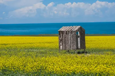
Qinghai Lake is situated on a high plateau, with an average temperature of only around 15°C in July and August, which is the most beautiful time. At that time, thousands of acres of rapeseed flowers around the lake bloom in succession, the vast blue lake is dotted with golden light, and wildflowers on the alpine pastures are colorful and silky. Countless fat cattle and sheep dot the landscape.
After a happy but tiring journey, you can rest one night in Xining.
From Xining, you can return to various places across the country. Let's meet again in the green mountains and clear waters, in the world of brotherhood.
Everyone has a dream of travel in their heart, no matter its size, no matter the distance in time and space. One day, we will carry our backpack without hesitation for this dream.
Dreams are not extravagant. Just bravely take the first step. Set off, and cheer up!