Observing Salt, Reading Colors: Lanzhou, Xining, Caka, Qarhan, East and West Taijinar, Dachaidan, Mangya Emerald Lake, Aiken Spring, Hoh Xil
On the 2020 National Day trip through Gansu, Qinghai, and Inner Mongolia, dubbed the 'Left Hook,' the most unforgettable memories were not the mysterious Crescent Moon Spring at Mingsha Mountain, the majestic Jiayuguan Pass, nor the dreamy Ejina poplar forests; what lingered in my mind and haunted me constantly were the salt lakes of all sizes scattered across the Qaidam Basin—blue, green, red, yellow, white, a riot of colors, some bright and mirror-like, others rippling like scales. Last time, to get to Ejina, the itinerary was tight; a quick glance left me wanting more. This time, the goal was clear: go after all the saline lakes and salt lakes. Qaidam, here I come again.
Arriving in Xining, I usually transit via Xi'an or Lanzhou. If via Xi'an, then Xi'an is also a major part of the itinerary. If in a hurry, I never tire of taking advantage of the 48-hour layover perks at Xianyang Airport, always unlocking a new way to play. If via Lanzhou, cost-effectiveness comes first, saving time and money. Each time I stay a day or two, and after several visits, I've explored Lanzhou thoroughly.
Last time in Lanzhou, it started with a bowl of Lanzhou lamian—the correct term should be Lanzhou beef noodles. This time, I swapped it for Hu's Baozi as afternoon tea (the airline meal from lunch had long dissipated). One basket of beef baozi, half a basket of vegetable baozi and half a basket of sweet baozi, plus a bowl of eight-treasure fermented rice. 'Quality, taste, and value for money,' the four of us, famished, could only manage one of each per person.
After eating and drinking our fill, we headed straight for the Yellow River Cable Car. Last time we arrived too late, and the queue was too long; by the time we got there, tickets had stopped selling. The cable car cabins come in groups of three, and I counted four sets of colors: red, blue, yellow, and white, cycling continuously. Lucky for us, we got into cabin number one, which was convenient for taking photos.
Exiting the cable car, we turned left first to the Lanzhou Forest of Steles, overlooking the entire city and the Yellow River cutting through it.
Our plan was to wait for sunset and watch the lights come on in the Golden City, but today the cloud cover was thick, making a sunset unlikely. Plus, sunset in western cities is around 8:30 PM. To conserve energy for the rest of the trip, we knew when to stop and instead switched to watching the Zhongshan Bridge light up.
After the forest of steles, we descended along the Baita Temple path. At the foot of the hill, we encountered a steady stream of people, young and old, climbing up step by step. Could climbing Baita Mountain be a daily pastime for Lanzhou residents? With all this beef and lamb they eat, their calcium levels must be top-notch, beyond what we could ever match.
The locals were all on Baita Mountain, while Zhongshan Bridge was taken over by tourists—packed so tight you could barely move. We walked from the north end of the bridge to the south, didn't pause, and headed back to the hotel!
The magazine 'Reader'—I read a few issues as a child, but never looked into where its publishing house was. While doing research this time, I unexpectedly discovered that the 'Reader' publishing house is in Lanzhou. Let's go together!
Crossing the Jinyan Bridge, the Yellow River under the bright sun looked more like the Red River.
On Reader Avenue, we first encountered the Dunhuang Art Museum, which has replicated Mogao Caves. Standing before the Eastern Smile, could this humble self have even a hint of spiritual insight?
The Reader Building is open to the public, housing the Reader Museum and the 'Reader' Illustration Art Gallery. Walking in, it was filled with memories of youth—carefree and unaware of sorrow, who hasn't once dreamed of being a literary youth?
Lanzhou City Museum, built on the site of the original Ming Dynasty White Temple. The White Temple Pagoda (Duozi Pagoda) resembles the white pagoda on Baita Mountain in shape, but the tower itself is a rare even number: 12 stories with 96 sides, 96 Buddha statues and 96 wind chimes. Indeed, from afar, hearing the wind chimes speak of the rise and fall of dynasties.
Gansu Provincial Museum. On the first floor, there was a special exhibition of fine Ding ware from the Ding Kiln, quite generous in displaying four pieces of white Ding porcelain for visitors to touch and appreciate. For the first time, I had the opportunity to handle famous porcelain—the texture was indeed delicate, and even though they were replicas, they lived up to the reputation of 'white as jade, thin as paper, clear as chime.'
Fossils of the Yellow River ancient elephant—the best-preserved and largest individual ancient elephant fossil discovered in the world today. What's on display here are replicas; the originals are in the Beijing Museum of Natural History.
Bronze Galloping Horse (fortunately, from May 1 to October 15 each year, the real artifact is on display). A masterpiece combining ancient Chinese mechanics, aesthetics, and craftsmanship at their peak. Viewed from the side, the divine horse is vigorous and exquisite, head raised in a neigh, three hooves in the air and one hoof skimming over a flying bird—truly worthy of being the symbol of Chinese tourism. But then, when you look at it from the front, in a haze of confusion, the 'horse stepping on a swallow' instantly becomes a 'crazy donkey stepping on a chicken.' With this, the show-off earns extra cash at the museum's souvenir shop.
Lanzhou Old Street, a mock-ancient style street, where we took some photos and had dinner. The real thought was to find Old Ma; the Zhenning Road Old Ma's milk and egg fermented rice had moved, but I was lucky to see the real person again. Honestly, I felt the ingredients weren't as generous as last time at the Zhenning Road night market.
Finally, a word on the Xiguan Grand Mosque. Now it's hidden away, and without the four once-towering minarets, it's easier to get the whole view in frame.
Because our return flight changed, we actually ended up spending two half-days in Xining, so I won't split them into two sections; I'll combine them here.
With only two half-days, we just visited the museums and mosques in the city center.
The provincial museum near Xinning Square.
In the north of the city, the Qinghai Tibetan Culture Museum, whose main building has a bit of the Potala Palace's charm. The north hall is the Qinghai Tibetan Medicine Culture Museum, and the south hall is the Qinghai Tibetan Culture Museum. Nearby, there are also the Qinghai-Tibet Plateau Natural Museum and the Kunlun Jade Culture Museum, worth a visit if you're in the area.
Dongguan Grand Mosque, Yudai Bridge Mosque, and Nanguan Mosque are not far from each other, reachable on foot, so we checked them all off. However, these places have changed from two years ago as well.
Dongguan Grand Mosque offers a 5-minute expert guided tour every hour during opening hours.
Yudai Bridge Mosque looks quite pretty when lit up at night.
Nanguan Mosque does not allow entry for visits.
Nanchuang River Kunlun Bridge.
Gongchen Gate in the afterglow.
This trip was at odds with Xining; we encountered two rains. The first rain happened to be in an area with poor drainage, and we witnessed how Xining turns into 'Qinghai' when it rains.
The second time, after dinner, we wanted to see the Dongguan Grand Mosque lit up but didn't wait for the lights. Instead, a 'light rain' drove us back to the hotel, and we missed out on night snacks at Nanguan too.
The prelude was sufficient; the journey of 'Observing Salt, Reading Colors' began. Not fond of writing a daily itinerary, I'll divide it into three parts based on landscapes.
The route passed through national roads and expressways including G109, S2013, S20, G315, G3011, G215. Leaving Hei Ma He, crossing the Xiangpishan summer pasture, we gradually entered arid desert terrain, with vegetation becoming sparser. On the straight roads, besides oncoming cars roaring past, and occasionally eagles flying overhead, the most faithful companions were the transmission towers standing by the roadside and the tall windmills on distant hillsides. As the saying goes: 'The sun rises and brings color, the wind blows and perhaps brings sound. Two tracks of rail stretch straight, a horse's hooves lightly bound.'
Speeding along this horizon, with blue sky and white clouds above and a world of dust yellow below, I couldn't help but daydream, only to be jolted awake from drowsiness by surprise after surprise (unexpectedly returning to the state of getting out to take photos and sleeping on the bus).
Hei Ma He parking lot.
Without warning, a three-on-one battle among yaks quietly unfolded.
Dachaidan Emerald Lake parking lot.
Meeting a motorcyclist on the road: one word: cool!
G315 U-shaped road.
This time it was not peak season, with few cars and few people, so I got bold and took a photo right in the middle of the road.
Nanbaxian Devil City.
This stretch of oddly shaped yardangs of various sizes and heights, large and small, stretches nearly a hundred kilometers long and tens of kilometers wide. Wind-eroded earth mounds are arranged in staggered rows along the wind direction.
G215 runs through it, making it appear even more boundless, wild, and desolate. Climbing to a high spot, looking around: 'The sky is high, birds vanish; a thousand paths, no human traces.' 'Ask the vast earth, who decides the rise and fall!' Just as I was about to roar at the sky, a demonic wind arose from nowhere, blowing sand into my face and mouth. Ptoo, ptoo.
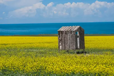
Qinghai Lake is a saline lake, needing many more years to join the ranks of salt lakes. The shores are all fenced off by herders; aside from Erlangjian, you can't approach the water easily. There are two openings on the west side, one recently closed for reasons, the other a cliff too far away, so we didn't go. The most beautiful time at Qinghai Lake is of course during July and August when the rapeseed flowers bloom. From the south shore looking north, in the foreground are bright yellow flower fields, then the deep blue lake, across the lake are pale yellow gobi and greenish Datong Mountain, and further up, white clouds rise from distant peaks, swaying into the clear sky. Large patches of cool and warm colors interlace, a strong visual impact that opens the heart and makes you want to sing. Indeed, it was late June, just a week apart on the return trip, a patch of rapeseed flowers had already bloomed in the wind, adding to the beauty of this trip.
At Hei Ma He, the biggest gain was seeing the famous Huang fish for the first time. The fish were swimming upstream against the current, migrating.
Wusute Yardang (Water Yardang) Geopark. This time, we found a viewing platform outside the scenic area and just looked. Unfortunately, we went the wrong direction the day before; after West Taijinar, it got dark, so we let it go. The view of the invincible fleet from a little elephant's perspective. Maybe the air was poor in the morning, the visibility not clear; better to come when the sky is clear.
Aiken Spring, a paid scenic spot, can only be viewed from a makeshift high platform built with a lift truck. From there, you can see the spring water continuously bubbling up from the spring eye. Without a drone, you can't make eye contact with the 'Demon's Eye,' let alone see a thousand years at a glance.
Gas Hure Lake Blue Hole: the journey there was full of twists and turns, a true adventure. The road to the lake was reportedly closed due to a tourist accident a couple of days ago. But then we saw promotional images for the Blue Hole at the Mangya Emerald Lake ticket office, and eventually, we shared a ride to the scenic shuttle bus. To be honest, without a guide familiar with the terrain, it's almost impossible to find the Blue Hole in this dry salt flat. The salt crust, eroded by rain and snow, is uneven and full of pits; you can only enter on foot, which is hard on shoes and easy to twist an ankle. Once inside, the surrounding terrain looks similar, with no landmarks, making it hard to return the same way. The Blue Hole hides in the salt marsh, mostly slightly below ground level, hard to spot without getting close. When the little elephant took off, it was clear at a glance: dozens of salt springs scattered around like inlaid multicolored gems—sky blue, sea blue, snow white, earth yellow, brownish red—like a Persian cat's eyes flashing with the blue sky, drifting clouds, stars, moon, and the Milky Way...
Next, the six major salt lakes, paired off for a 1v1 PK.
Caka Salt Lake. This should be my third visit. Maybe it's destined not to get along; I've always failed to see its ultimate beauty. The first time, it was sunny when I entered, but I dawdled into the scenic area, and gradually saw clouds gathering. I left regretfully, only to look back and see the clouds part. The second time, it was like black clouds pressing to destroy the city. So in 2020, I got to the gate early in the morning, saw it was overcast, and headed straight for Dachaidan. This time, the sun was blazing; it should have been foolproof. But as soon as I entered, I saw cloud-pushing boys at the horizon arranging their troops. I thought it was still early; if it rained, the clearing after rain would still be fine, so I kept the eager Dumbo in my bag. Who knew the rain would just hold off? Seeing no action, the Wind Lord stepped in instead, a fierce wind sweeping across the empty lake, stirring up the salt brine from the bottom, making the visual and olfactory experiences far from pleasant. Fine, fine, I won't come again.
Mirror of the Sky, I've done my best.
The salt sculptures in the first part of the scenic area are somewhat interesting.
Qarhan Salt Lake. When I entered in early October last time, the sun was bright but the wind was biting, almost making me want to ride the wind away. A glimpse left me stunned by its beauty, but I couldn't stay long and left in a hurry, always regretful. Over the years, the scenic area has been upgrading, I suppose? Cute SALT DUDU and Salt Brine Brine have moved in, and new attractions like 'Jasper Pavilion' and 'Emerald Water Terrace' have been added.
Qarhan Salt Lake is crystal clear to the bottom; crystallized salt flowers and salt crust are white and sparkling, like ice or snow. The lake water reflects the sky, showing off colors like emerald green, deep blue, pale yellow, and snow white, like a dream world.
First round: Caka vs. Qarhan, Qarhan wins.
East Taijinar Lake. Before departure, the information I got was that it had been fenced off by a mining company, with trenches dug and roads cut. Some netizens even reported a wooden pole at one spot over the trench, which you could vault over, and there were photos to prove it. When the time came, the latest news was that you could still see the lake, just couldn't get to the water's edge. That's fine; as long as I could see it, the little elephant could do the job. True or false, East Taijinar was on the way to Water Yardang, so it wouldn't hurt to check.
At the East Taijinar parking lot, it felt promising. Walking from the parking lot to the lakeside was a short few hundred meters, but my mood was anxious and uncertain—eager to see the beauty but afraid of disappointment. As I got closer, white salt flats and powder-blue lake water gradually came into view. Stunning! Last time, there was just a narrow river about ten meters wide between two salt banks. Now, the water and sky merged into one, an endless lake of dreamy charm, with a pure white salt spit extending into the shimmering water. At that moment, I was lost in a dream, speechless.
West Taijinar Lake. Because we went the wrong way to the viewing platform outside Water Yardang, we moved West Taijinar up from the next morning to that day. Heading west, the navigation showed we were already in the lake area, but besides slow-moving trucks, we didn't see any travelers gathering. The color difference between the water on both sides seemed small, and disappointment set in. Seeing the setting sun, I almost turned back, but I released the little elephant, which had only one fully charged battery left, to snap some photos of the sunset. Who knew you couldn't see the true face of West Taijinar because you were inside it? G315 runs east-west, splitting the lake into two halves—one bright green, one deep blue. Salt crusts in the lake surface protrude like islands and reefs of various lengths. Unlike other salt lakes, West Taijinar seems to have salt-tolerant algae growing in it, with occasional seabirds resting, full of life. At that moment, the drone was flying alone with no signal interference, no obstacles, and apart from the 120-meter altitude limit, it almost flew to its maximum range. So satisfying!
Second round: East Taijinar vs. West Taijinar, East Taijinar wins.
Dachaidan Emerald Lake. It has become a paid scenic spot; private cars are not allowed in. Most tourists gather by the lakes near the shuttle bus stops; the more distant lakes are less crowded. Dachaidan Emerald Lake's various lakes differ in shape, size, and color—emerald green, yellow, deep blue. Even within the same lake, the color changes with depth, like color blocks on a palette. With distant snowy peaks and blue sky reflected, it's easy to capture a mirror of the sky.
Mangya Emerald Lake. Cut by lake embankments, the lake is square in shape, with water a vivid emerald green, truly sparkling like jade. The lake surface is covered in white net-like salt crystals, and with the wrinkled distant mountains, the little elephant can fully exploit its creativity. Can you still tell which is the sky and which is the lake?
Third round: Dachaidan Emerald Lake vs. Mangya Emerald Lake, Mangya Emerald Lake wins.
After the competition, the final ranking:
1st place: East Taijinar Lake (naturally unadorned, a pleasant surprise)
2nd place: Qarhan Salt Lake (the quintessence of salt lake scenery)
3rd place: Mangya Emerald Lake (definitely a glass-grade green jade)
4th place: Dachaidan Emerald Lake (slightly less dashing)
5th place: West Taijinar Lake (its beauty can only be appreciated through aerial photography)
6th place: Caka Salt Lake (karmic mismatch, reluctantly at the bottom)
I didn't originally plan a separate chapter, but this day was indeed interesting and significant.
Starting southwest of Golmud City, we entered the Qinghai-Tibet Highway section of G109, from Golmud to Lhasa totaling 1,215 kilometers. Today, we'd just do a small portion and then head back—a test run.
First stop: Kunlun Mountain Gate, elevation 2,780 meters. On both sides of the road stand two towering stone tablets inscribed 'Majestic Kunlun' and 'Ancestor of All Mountains.' Later, searching online, I learned that the shape alludes to 'The Hill of Kunlun,' the oracle bone script character for 'hill.' Does entering this gate mean I've become an immortal?
Second stop: Chinatai, elevation 3,700 meters. Unnoticed, we'd climbed nearly a kilometer. We filled a few bottles of Kunlun Sacred Spring, whose temperature is a constant 7°C year-round, to bring back to the hotel for tea—a gesture not unworthy of the host's hospitality. Who knows how many years it might extend life.
Passing the Sancha River Grand Bridge. In the early part of this journey, the Kunlun River accompanied us; throughout, the Qinghai-Tibet Railway frequently intersected our path, with long freight trains rumbling by not far away. The vegetation along the route was quite rich, much more interesting than the Gobi with only a splash of yellow earlier.
Third stop: Wuji Longfeng Palace, elevation 3,800 meters. This time, we could actually enter the halls.
Opposite the Kunlun Mountain Mineral Water Co., Ltd., a range of snow-capped peaks stretched; I wondered which one was the Jade Maiden Yuzhu.
Fourth stop: Kunlun Mountain Pass, elevation 4,767 meters—another thousand meters up, the highest point of this trip. Just then, traffic jammed; the line of westbound trucks seemed endless. A good opportunity to stop and rest, and at the highest altitude, 'sing a loud song.'
The spirits of Hoh Xil, the Tibetan antelopes, came to greet us, very shy and wary of humans. That protective coloration is really effective; if not for the long horns, you'd hardly spot them.
Final stop: Sonam Dargye Protection Station, elevation 4,479 meters.
We devoured all the supplies we'd prepared in Xining and then headed home.
Seeing us off were the internet-famous wolf (probably not the same husky) and wild donkeys—treatment of no low standard.
This trip: I've traveled the Qinghai-Tibet Highway, been to Hoh Xil, seen wild wolves on the plateau, entered and exited Kunlun Mountain Pass. I dare not claim to be a hero among experts, but easily surpassing a billion people is no boast. Dear readers, don't bother me unless it's urgent; let me dream on. 'Bells and drums, fine food are not worth cherishing; I wish to stay drunk and never wake up.'
Travelogue Contents: 1. Lanzhou 2. Xining 3. Highways 4. Salt Lakes 5. Hoh Xil Nature Reserve
Tourist Information: Hotel Index, Tour Index, Airline Index, Website Navigation, Travel Index, Cruise Index, Corporate Travel Index, Joining Cooperation, Distribution Alliance, Friendly Links, Corporate Gift Card Procurement, Insurance Agency, Agency Cooperation, Hotel Franchise, Destination and Scenic Area Cooperation, More Joining Cooperation. About Ctrip: About Ctrip, Ctrip Hot Topics, Contact Us, Join Us, User Agreement, Privacy Policy, Business License Security Center, Ctrip Content Center, Intellectual Property, Trip.com Group Algorithm Disclosure