Two-Day Self-Drive Tour of the Anhui-Zhejiang Sky Road
Every summer I always take a short trip, but due to work I usually only manage to spare two days. And I have a special fondness for mountains, so northern Zhejiang and southern Anhui, which are relatively close to Wuxi, are my first choices. In previous years I went to Anji, but this year I decided to switch places and planned to go to Lin'an and Jixi on the Anhui-Zhejiang border.
Following the plan I had made earlier, I set out on the morning of August 2nd. Around 2 p.m. on the Hangzhou-Ruili Expressway, I saw the continuous mountain peaks ahead like a dark, towering wall piercing the clouds, with an imposing aura. I knew I was near Qingliang Peak. Qingliang Peak is the main peak of the Tianmu Mountain range and the highest peak in northwestern Zhejiang, with an altitude of 1,784 meters, ranking high even in East China. At 2:30, I exited the expressway at Jiaze Interchange and drove along a small road for about half an hour before finally reaching a village inn in Shichangcheng Village. The road was being widened all along, and due to recent rains, there were many landslides. The road conditions were quite bad, with most sections being bumpy and potholed. The car, raising dust, wobbled forward like a boat in wind and waves. Especially when meeting oncoming cars on the narrow road, even an experienced driver like me was terrified. Fortunately, the scenery along the way was not bad. By the roadside was a deep stream, flanked by thousand-meter-high mountains. Passing through the filming location of "A Chinese Ghost Story," the "Sword Gate," I saw a crack in the middle of a hundred-meter-high stone wall, truly living up to its name as a stone gate.
Behind the inn where we stayed was a small stream, but unfortunately, due to mud from the road construction flowing in, the water was a bit murky. To find a clear place for swimming, I had to try my luck and walk upstream. After a few minutes, I encountered a small waterfall cascading straight down from the opposite mountain. Here the water was already crystal clear, but the riverbank was deep and steep with no path down. Continuing upstream for a hundred or two hundred meters, I finally found a suitable spot to descend to the riverbed. I couldn't wait to have close contact with the stream water. The water was cool, and at its deepest point, it just exposed my nose. Swimming in this crystal-clear mineral water was really refreshing.
Soon it was dinner time, so I hurried back to take a shower and change into dry clothes to enjoy the farmhouse dinner. In high spirits, I drank a bit too much. In the pitch dark, I still wanted to take a walk up the mountain. This is the Qingliang Peak National Nature Reserve. The innkeeper said there are many wild animals, including leopards and jackals, even more monkeys and wild boars, and sika deer. Emboldened by the alcohol, I walked up the mountain all the way, taking advantage of the unusually bright moonlight. The higher I went, the farther I climbed until I got tired but hadn't even reached the mountainside. To save energy, I had to return dejectedly. I woke up at around three in the morning and couldn't sleep, so I went to sit on the balcony. By then the moon had set, leaving only the stars still shining. The chilly mountain wind blowing on me was a bit cold, and after sitting for a while, I fled back to the room. Half-asleep until dawn, I pulled open a corner of the curtain and saw that the stream water had become crystal clear again after a night without construction.
After breakfast, following the route the innkeeper indicated, we went to the mountain behind the Shichangcheng Village Committee. This place was just like the Sword Gate, with mountain bodies like high walls on both sides breaking apart in the middle, forming an opening called the "Tiger Gate." To the right of the stone gate, a huge rock leaned precariously, giving the feeling of Mount Tai pressing down when viewed up close. In the middle of the stone gate was a mountain stream. Because upstream is an uninhabited nature reserve, the water quality was completely drinkable mineral water. The innkeeper said there were many wild monkeys here, but we didn't encounter any. Not to mention monkeys, we didn't even see a single person. We enjoyed this beautiful scenery all to ourselves—an experience that cannot be had by visiting paid scenic spots.
Returning to the inn to pack our luggage and bidding farewell to the innkeeper, we officially began our journey on the Anhui-Zhejiang Sky Road. The Anhui-Zhejiang Sky Road includes the Langguang Highway in Lin'an, Zhejiang, and the Jingzhou Highway in Jixi, Anhui. Among them, the highest point of Jingzhou Highway is 1,158 meters above sea level, and the highest point of Langguang Highway is 1,357 meters, making it the highest-altitude highway in East China. We left the inn and headed west along the Jiaze Line. The road was even more difficult than the one we came in on, with construction everywhere. Dust and bumps were no longer a big deal. What I dreaded most was having to stop every few minutes to wait for oncoming cars to pass. The road was so narrow that sometimes the driver ahead had to get out and direct traffic, otherwise no one could get through. Time and again, our car brushed past others—the feeling was really exasperating. The navigation kept announcing "passing through areas prone to rockfalls." Looking at the towering cliffs on one side and the deep valley on the other, my dad's face turned pale with tension. After wobbling along, we finally reached Langguang Village, already at an altitude of 800 meters. Large trucks carrying stones were speeding down one after another. Every time we met one, we had to find a slightly wider spot to pass. Finally, we got stuck at a small bend, and with difficulty we let a stone truck come down. From the driver we learned that the road ahead was under construction and impassable. Persuaded by him and a few other drivers, I decided to turn back. This was really a sad moment—setting out with high spirits, only to return disappointed. The uphill drive was tough enough, and now we had to go back the same way. This time I was destined to miss the Langguang Highway, known as the "West Zhejiang Tanggula." However, I couldn't give up on Jingzhou Highway. So we struggled all the way back to the starting point. Passing by the inn again, we met the innkeeper once more and said goodbye again—only I know the feeling in my heart. Since this road was blocked, we had to take the Hangzhou-Ruili Expressway to National Highway 303, then take Daoshang Line to Jingzhou Township, Jixi, Anhui. The Daoshang Line mainly runs along a stream, with narrow roads and many curves. Especially the Lin'an section had road construction everywhere, testing both driving skills and the car's undercarriage. But traffic was light, and the scenery along the way was still great. Shortly after entering Anhui, the small stream made a 180-degree turn. On the peninsula in the river bend, a stone pillar rose straight into the sky. From a certain angle it looked like a Green Dragon Crescent Blade, so locals call it "Guandao Peak." In fact, this peak presents different effects from different angles. Not far ahead, we reached the Jingzhou Township Government Office. This was a small mountainous township, roughly like the feeling of going to the main street when I was in junior high school. We had lunch at the Station Restaurant beside the township government. Five dishes cost 135 yuan—compared to the dinner at Shuiyunjian last night, it was both delicious and cheap.
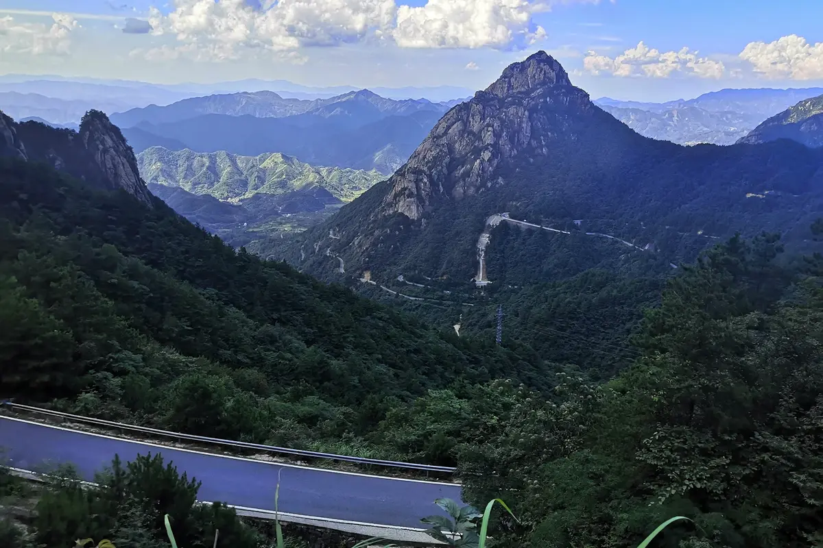
This was the starting point of the "Jingzhou Highway," one of the three great sky roads in southern Anhui, ending at Jiapeng Township on the other side of the mountain. The total length is 30 kilometers, with 351 curves and 21 switchbacks. The highest point is at Shanyunling Pass, with an altitude of 1,158 meters, the highest point of a highway in southern Anhui. The road here was all uphill. Except for the wide views, the scenery was only average. After crossing the mountain pass, the road began to descend, with even more curves. Turning around a bend, I was suddenly struck by a sight—looking down, a conical peak stood out.
This peak is less than a thousand meters high, not particularly tall compared to the surrounding peaks of 1,300–1,400 meters. But it rises abruptly from a flat valley, with an extraordinary momentum. Its exposed, mottled granite body stood out strikingly against the layered green mountains in the distance. Spiraling down, I stopped at almost every scenic viewpoint to admire this beautiful mountain. On one section of the road, I could clearly see the entire peak and the winding Jingzhou Highway spiraling down its mountainside. Continuing down to a col, I stopped to rest. This was the largest parking spot on the entire Jingzhou winding road, with a public restroom nearby. Moreover, the cool breeze here was even cooler than inside the air-conditioned car. If camping here at night, I would probably need a blanket. The only drawback was that the scenery here was average. After a short rest, I continued downhill. When I turned the fourth hairpin bend, Xiao He's sharp eyes spotted a small sign for a Jixi Hundred Photography Spots. There happened to be a small open space nearby, and I didn't hesitate to stop. This decision was definitely the best I made on the entire trip. First, I looked at the charming conical peak from the roadside, while Xiao He went ahead to explore the photography spot. In a few minutes, he ran back saying he had discovered a waterfall. I quickly followed him along a small path and soon arrived at the waterfall. The water fell vertically from a height of more than ten meters onto a stone platform halfway down, then cascaded down a smooth granite slope, forming a two-tier waterfall. I took off my shoes and climbed up the granite rock wall to the middle platform. The water had scoured a shallow pool on the platform. Standing under the waterfall, letting the icy stream water flow over my feet, it was really a chill to the bone and a soaring heart. After enjoying it enough, I found that the slope was slippery and steep. After a moment of hesitation, I had to grit my teeth and climb down using both hands and feet. Fortunately, I was still agile, and I landed safely without incident. This place was not only good for viewing the waterfall but also one of the best spots for viewing the mountain. A granite peak several hundred meters high rose abruptly, shaped like five fingers, hence named "Wuzhi Peak" (Five Finger Peak), somewhat resembling the grandeur of the smaller Huangshan. Here it was close to the foot of the mountain. Continuing down, the scenery became average. Near the bottom of the basin, there was a huge rock by the roadside with the three characters "Meiqianling" (梅圲岭) clearly inscribed on it. Overlooking the layered terraced fields and the black-tiled white-walled Huizhou ancient village backed by the mountains, it was a beautiful pastoral scene.
Ahead was the end of the Jingzhou Highway, the ancient village of Kantou in Jiapeng Township. I had planned to visit it, but due to the narrow streets with no place to park and the time being close to evening, I had to give up. With a touch of regret, we drove four hours back to Wuxi.
Travel Notes Directory:
1. Two-Day Anhui-Zhejiang Sky Road Trip
Tourism Information
Hotel Index
Strategy Index
Ticket Index
Website Navigation
Travel Index
Cruise Index
Corporate Travel Index
Join Cooperation
Distribution Alliance
Friendship Links
Enterprise Gift Card Procurement
Insurance Agency
Cooperation Agent
Hotel Alliance
Destination and Scenic Spot Cooperation
More Cooperation
About Ctrip
About Ctrip
Ctrip Hot Topics
Contact Us
Careers
User Agreement
Privacy Policy
Business License
Security Center
Ctrip Content Center
Intellectual Property Rights
Trip.com Group Algorithm Publication


