Huihang Ancient Trail Hiking Travelogue
Huihang Ancient Trail Hiking Travelogue
2021-9
Long admired the fame of Huihang Ancient Trail, it is said to be an excellent place for hiking.
Taking advantage of the off-season before National Day, I decided to experience the flavor of Huihang Ancient Trail in person. Although it was already mid-autumn, the weather was unseasonably hot.
I did some simple preparation, entering the ancient trail from Jixi, Anhui, and turning back at "Blue Sky Pass", completing the entire journey within the same day, with a scheduled time of nine hours.
I booked two nights' homestay in Daixia Village, not far from the entrance, through Ctrip, convenient for self-driving.
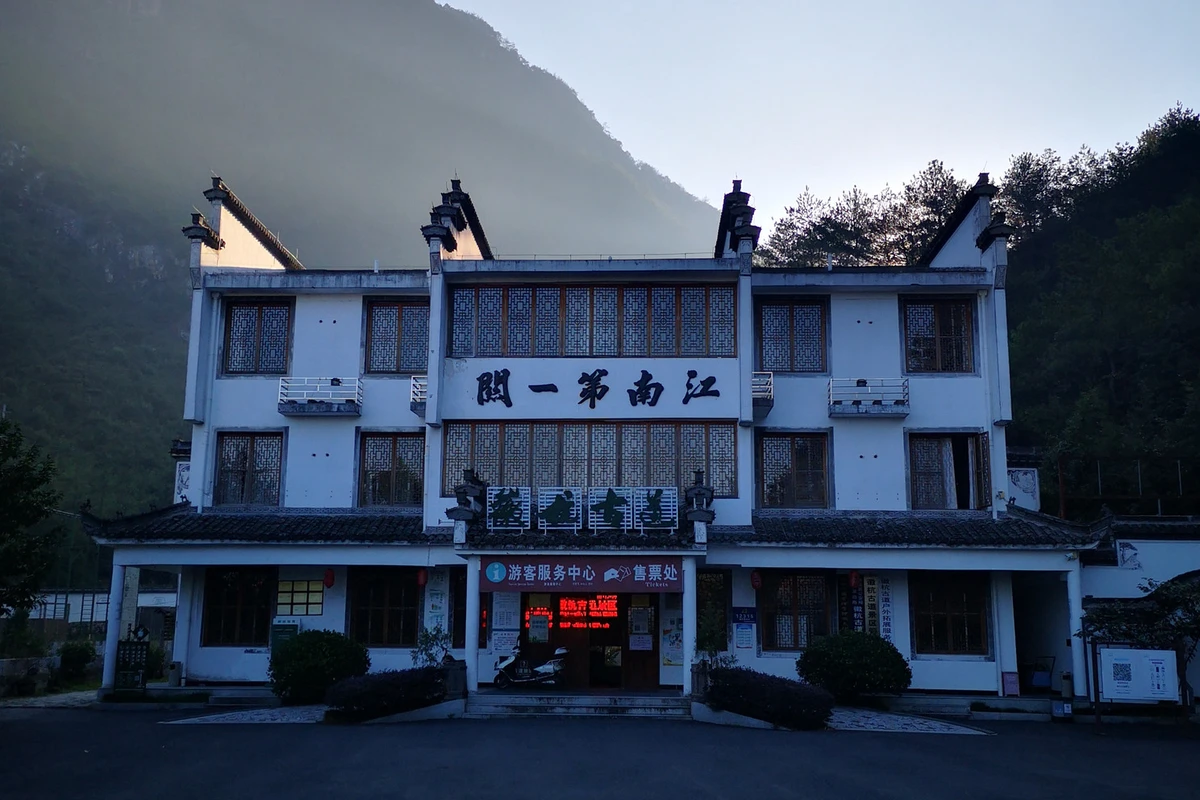
Early that morning, I prepared some food and water, put them in my backpack, packed light, and drove about three minutes from the inn to the "Jiangnan First Pass" Visitor Center (Figure 1). I parked the car at a simple parking area by the roadside not far from the center.
Figure 1: "Jiangnan First Pass" Visitor Center
Figure 2: Yankou Pavilion
Crossing a bridge led to Yankou Pavilion (Figure 2), where there was a ticket checkpoint. Starting from Yankou Pavilion, I officially entered the ancient trail (Figure 3). It was 7:30 in the morning.
Figure 3: Officially entering the ancient trail
Figure 4: This ancient trail is a national key cultural relic protection unit
A fairly wide stone-paved path stretched ahead, gentle in slope, easy to walk. On the right side, a waterfall cascaded down the green mountain (Figure 5). Along the way, I enjoyed the scenery until reaching "General Stone" (Figure 6). Here the path diverged: to the right was the later-built "Xiaoyao Valley", which was the route planned for the return trip; to the left was the original ancient trail.
Figure 5: A waterfall
Figure 6: General Stone
Starting the ascent, the path was still stone-paved, but noticeably steeper and narrower than before. Climbing upward, it was said to involve about 1,400 steps to reach the true "Jiangnan First Pass" (Figure 8). The pass was supported by several stone slabs, with the lintel inscribed "Jiangnan First Pass" and the back inscribed "Key to Huihang". Although simple, it had a certain grandeur. Behind the pass was an observation deck, with cool breezes and boundless scenery (Figure 10).
Figure 7: It is said there are 1,400 stone steps to the pass
Figure 8: Jiangnan First Pass
Figure 9: The back of the pass inscribed "Key to Huihang"
Figure 10: Observation deck
Figure 11: Historical account of Jiangnan First Pass
Beyond "Jiangnan First Pass", the path continued uphill, but most sections were relatively gentle, basically stone-paved, with dirt paths on flatter stretches. This section offered beautiful scenery: cliffs on the left and deep ravines on the right (Figure 12). Sights like "Buddha Palm Peak" (Figure 16) and "West Temple Waterfall" (Figure 17) could be admired, but unfortunately the weather was too hot, and the water of "West Temple Waterfall" had dried up, leaving only a clearly visible water channel, greatly diminished.
Figure 12: Deep ravine on the right
Figure 13: Cliff on the left
Figure 14: Overlooking Xiaoyao Valley
Figure 15: What does this protruding rock look like?
Figure 16: Buddha Palm Peak
Figure 17: The water at West Temple Waterfall has dried up
Along the way, I occasionally encountered local villagers heading to Fuling Town for the morning market, showing that the ancient trail remains an important route for local people to connect with the outside world (Figure 18).
Figure 18: Going to the market
Located halfway up the mountain, "Tea Pavilion" (Figure 19) is a main rest stop on Huihang Ancient Trail and also the confluence of the old mountain path from Jiangnan First Pass and the plank road of Xiaoyao Valley. Stopping here for a short rest allows one to fully enjoy the canyon scenery.
The subsequent road was relatively flat.
Figure 19: Tea Pavilion
Passing through "Huangmaopei". This is a natural village, not large, but the houses stretch far from east to west, giving a scattered feel. There are homestays and inns; many hikers who enter the ancient trail in the afternoon choose to stay here for a night (Figure 21) and continue the next day. Simple tea stalls and small restaurants by the roadside offer short breaks for visitors.
Figure 20: Huangmaopei
Figure 21: Gudaorenjia Inn
From "Huangmaopei", a very crude road leads northeast to "Xiaoyao Village". Small cars can drive out of the mountains via this road. Following the road eastward, it was actually a narrow road, with long stretches wide enough for only one small car, and the surface was covered with stones of various sizes, not easy to traverse. However, this section passed through the Qingliang Mountain Forest Reserve, winding along a small stream, with dense vegetation on both sides and fresh air. Walking while admiring the green mountains and clear water, after climbing a fairly long uphill slope, it still felt quite relaxing.
After walking about four or five kilometers from Huangmaopei, there was a pavilion for tourists to rest. On the right side of the pavilion, a small downhill path crossed the stream. This was a shortcut to "Xiaxuetang", saving about one li compared to following the road. Many travelers chose this shortcut. Taking the shortcut was more tiring: after crossing the stream, one had to climb a steep zigzag mountain path (Figure 23) until it rejoined the simple road at "Xiaxuetang" (Figure 25).
Figure 22: Crossing the stream
Figure 23: Climbing up the zigzag path
Figure 24: Taking the small path offers many beautiful views
Figure 25: The small path meets the simple road
"Xiaxuetang" is a relatively large village with homestays and restaurants (Figure 27). One can take a good rest here and replenish energy. There is also a branch path from "Xiaxuetang" leading to "Zhangshan Grand Canyon" (Figure 28), another beautiful natural scenic area in Jixi. But it was said that this path is not always open to tourists.
Figure 26: Xiaxuetang
Figure 27: Xiaxuetang has homestays and restaurants
Figure 28: Leading to Zhangshan Grand Canyon
From "Xiaxuetang" to "Blue Sky Pass" there was still about 3 kilometers of mountain road. Leaving "Xiaxuetang" meant climbing (Figure 29) all the way to "Shangxuetang".
Figure 29: Climbing again
"Shangxuetang" had little to offer; only a blue iron-sheet house served as a landmark (Figure 30), which was easy to overlook. Passing "Shangxuetang", the uphill path became relatively flat, a dirt road with gentle slope, sandwiched between two mountains, gently advancing. Before I knew it, I arrived at "Blue Sky Pass". If not for a signboard reading "Blue Sky Pass" (Figure 31), I might have thought I had just reached "Shangxuetang".
Figure 30: Shangxuetang
Figure 31: Blue Sky Pass sign
Figure 32: The flat grassland at Blue Sky Pass
Although it was already late September, the climate was unusual this year, with temperatures still above thirty degrees Celsius. That day was sunny and extremely hot; I was drenched in sweat from the journey. When the tea stall owner confirmed that I had indeed arrived at "Blue Sky Pass", I was rather disappointed. After exerting so much effort to climb up, I only saw a relatively flat slope with nothing particularly worth admiring (Figure 32). The tea stall owner smiled at me and said that I needed to go another 800 meters, where the notch was the real "Blue Sky Pass". It seemed I was not alone in feeling that this "Blue Sky Pass" did not live up to its name. So I gave up the idea of taking a good rest and continued on. Fortunately, the dirt road for over 800 meters had little undulation, and I smoothly reached the notch (Figure 33).
Figure 33: The notch of Blue Sky Pass
At the notch, I could feel the sky and earth suddenly open up. A vast expanse of blue sky and white clouds filled my vision. Looking into the distance, I felt relaxed and joyful. The autumn breezes blew on my body, extremely refreshing, sweeping away all previous fatigue. Involuntarily, I opened my arms as if to embrace the rolling layered mountains in the distance. Below the notch, a small path wound eastward, leading to Yonglai Town in Lin'an. It was said that there were scenic spots like "Southern Heavenly Gate" and "Entering Scenery Pavilion" along that section.
Figure 34: The ancient trail leads to "Southern Heavenly Gate"
At Blue Sky Pass, I encountered a group of young students from a school in southern Jiangsu on a group outdoor activity. They had set off from the city early in the morning, entered the ancient trail at 9:30, and reached Blue Sky Pass around 12:30. Many of these students came empty-handed, wearing T-shirts and shorts, and a few big lads even shuffled along in sandals, holding a bottle of mineral water and a guide map, laughing and joking as they rushed over. After a brief rest, they continued noisily towards "Southern Heavenly Gate", saying that a bus was waiting for them at the Zhejiang exit for their return that day. Seeing them so relaxed, as if strolling around campus, made me envy their youthful vitality.
Figure 35: Scenery at the notch
Forced by the need to retrieve my car, I had to give up the section within Zhejiang, which was full of wonderful imagination, leaving an excuse for a future revisit. Reluctantly, I turned back.
It was already 12:30 when I reached the notch. After browsing and resting for nearly half an hour, I started back at 1:00 PM. Following the same route back, it was mostly downhill, including taking the shortcut through "Xiaxuetang", so the speed was relatively faster. On the way back, passing "Huangmaopei", I encountered a few foreigners carrying bulky hiking backpacks. They entered the ancient trail in the afternoon, seemingly planning to camp and cook at Blue Sky Pass, then climb Qingliang Peak early to watch the sunrise. Seeing them made me once again appreciate the rich tourism resources and endless charm of Huihang Ancient Trail.
Soon I returned to "Tea Pavilion". According to the original plan, I would leave the ancient trail here and return via "Xiaoyao Valley". To the left, a steep concrete stone staircase led downward in zigzag along the steep cliff to the valley floor, which was "Xiaoyao Valley".
"Xiaoyao Valley" is a plank road built by later generations along the stream at the bottom of the valley. Due to the hot weather, the water flow was not large. But the winding stream was clear and blue, sometimes tinkling, sometimes rushing. Stones of various shapes and sizes scattered in the mountain stream, blocking the water into scattered crystal pearls, playfully winding among the rocks. Close to the valley floor, the winding plank road built along the cliff was like a colorful chain stringing the pearls together, stretching slowly. Many interesting strange rocks competed to show off, changing views with every step: Tianjing Bridge, White Jade Beach, Laojun Cave, General's Platform, Sail Rock... (Figures 36-43). Along the way, a stone ladder shot straight up to the mountainside, pointing towards "Jiangnan First Pass". The majestic pass stood tall, incredibly beautiful (Figure 44).
Figure 36: Tianjing Bridge
Figure 37: White Jade Beach
Figure 38: General's Platform
Figure 39: Laojun Cave
Figure 40: Sail Rock
Figure 41: Pool
Figure 42: What does this strange rock look like?
Figure 43: Must bow down and pass through
Figure 44: Stone steps leading up to the Jiangnan First Pass pass
Figure 45: The majestic pass stands tall
Figure 46: Back under General Stone
Finally, I returned to the foot of "General Stone", and soon walked out of Yankou Pavilion. It was 4:30 PM, exactly nine hours, consistent with the estimated time. Getting into the car, returning to the inn, taking a shower washed away all fatigue. The pleasant trip ended.
Also about Huihang Ancient Trail
Huihang Ancient Trail starts from Yuchuan Village, Fuling Town, Jixi, Anhui in the west (Jiangnan First Pass Visitor Center) and ends at Yonglai Village, Lin'an, Hangzhou, Zhejiang in the east (Yonglai Visitor Center), with a total length of about 20 kilometers, crossing the Qingliangfeng National Nature Reserve.
The hiking route can be entered from "Jiangnan First Pass" in Anhui and exit from Yonglai Village in Zhejiang, taking about five hours overall. Some also choose to enter from Yonglai Village and exit from "Jiangnan First Pass", taking a similar time.
But for self-driving tourists with a car, no matter where you enter or exit, there is the issue of returning to get the car. It is understood that both the east and west entrances provide return vehicle services, which need to bypass via the Hangrui Expressway, about 80 kilometers, taking about two and a half hours. The return vehicle service is priced separately. To avoid trouble, many self-driving tourists choose to hike back and forth. Those who choose a round-trip hike mostly enter from Jixi and return from Jixi, because the scenic spots on the ancient trail are more concentrated on the Jixi section. There is a parking lot outside the Jiangnan First Pass Visitor Center.
For round-trip hiking starting from Jixi, the turnaround point can be determined according to one's physical strength and main travel goals. Generally, tourists who mainly focus on sightseeing choose "Tea Pavilion" as the turnaround point, round trip about three to four hours. Those with better physical strength and mainly for hiking more often choose "Blue Sky Pass", slowly walking round trip about eight to nine hours. Entering the scenic area in the morning, one can usually complete the whole journey or round trip within the same day; if entering in the afternoon, one can choose to stay overnight in the scenic area and continue the next day. There are good homestays in "Huangmaopei" and "Xiaxuetang", and many hikers choose to camp overnight at "Blue Sky Pass" with their own tents, which is also a good option.
Huihang Ancient Trail is well worth a visit. One can enjoy natural scenery, green mountains and clear waters, explore the traces of ancestors, and experience rustic village life. The air is fresh, the streams clean, the eyes full of green, and valley breezes blow constantly. It allows people to temporarily escape the hustle and dust of the city, return to primitive simplicity, forget all troubles, and invigorate themselves.
After all, Huihang Ancient Trail is a passage and not difficult to walk. Most sections can be considered smooth paths, and even the more strenuous slopes are paved with stone slabs. Except for a few steep sections, most climbing paths are not very steep. It is an excellent place for outdoor hiking activities suitable for men, women, old and young to exercise the body and temper the mind.
Even the shortcut from Qingliangfeng Bridge to Xiaxuetang entrance and the stone steps from Tea Pavilion to Tianjing Bridge, which are relatively steep sections, can be avoided by less physically strong tourists. For example, from Qingliangfeng Bridge to Xiaxuetang, one can take the simple road as a detour, which is only one kilometer longer but much easier; as for the section from Tea Pavilion to Tianjing Bridge, one can choose to take it as a downhill section, also saving the effort of climbing.
Huihang Ancient Trail is also a very mature tourist route, with many inns, restaurants, and pavilions along the way, providing affordable accommodation and meals for tourists to rest, and supplying sufficient water, food, and refreshments. Therefore, travelers generally do not need to make too complicated preparations, especially in fine weather; you can pack light and go anytime.
Huihang Ancient Trail is a tourist destination that you want to go to when you haven't been, and once you've been, you want to go again.


