Hidden Paradises in Sichuan, Yunnan, Qinghai, and Tibet: The Hengduan Mountains Unveil Shambhala (Part 1) — Land of Colorful Clouds (Yunnan)
Hidden Paradises in Sichuan, Yunnan, Qinghai, and Tibet: The Hengduan Mountains Unveil Shambhala (Part 1) — Land of Colorful Clouds (Yunnan)
1. Wonders on the Geographic Dividing Line. Wang Anshi believed that "extraordinary and magnificent sights often lie in perilous and remote places," and this is true. China's famous mountains and great rivers, World Heritage sites, 5A scenic spots, and diverse ethnic groups are highly concentrated along the boundaries of the three major terrain steps. The first step, above 4,000 meters above sea level, dominated by plateaus — boundary: Kunlun Mountains - Qilian Mountains - Hengduan Mountains. The second step, 1,000–2,000 meters above sea level, dominated by plateaus and basins — boundary: Greater Khingan Range - Taihang Mountains - Wu Mountains - Xuefeng Mountains. The third step, below 500 meters, dominated by plains and hills.
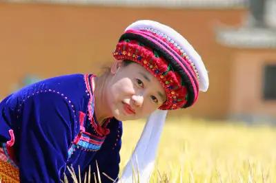
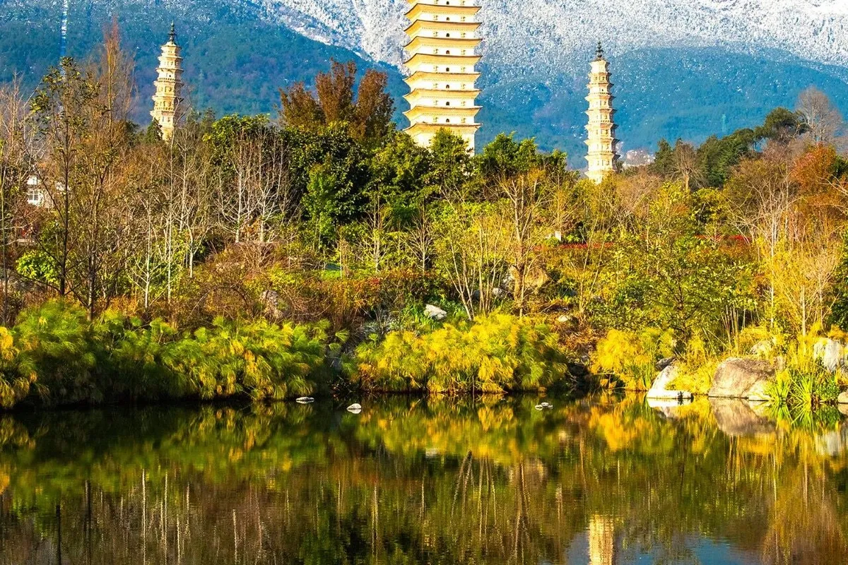
2. The Hengduan Mountains. During the Qing Dynasty, an official named Huang Maocai was dispatched to Tibet by Sichuan Governor Ding Baozhen. Gazing westward at the undulating mountain ranges, he exclaimed, "This is truly a 'hengduan' (transversely cutting) mountain!" This may be the origin of the name Hengduan Mountains. 65 million years ago, the Indian Plate collided violently with the Eurasian Plate from south to north, causing the Qinghai-Tibet Plateau to uplift dramatically and release pressure eastward and westward. On the eastern end, it met stubborn resistance from the Yangtze Plate. Where they clashed, the earth squeezed and compressed, forming large-scale folds and faults, creating the Hengduan Mountains. Mountain ranges usually extend in a certain direction, called the strike. Among China's many mountain ranges, east-west and northeast-southwest strikes are the most common, each with three groups. East-west ranges include the Tianshan-Yinshan, Kunlun-Qinling, and Nanling. Northeast-southwest ranges include the Greater Khingan-Taihang-Wu-Xuefeng, Changbai-Wuyi, and Taiwan Mountains. In addition to these two types, there are also north-south ranges, the most representative being the Hengduan Mountains in southwestern China. The Hengduan region includes seven north-south ranges (from west to east): Boshula Ridge - Gaoligong Mountains, Taniantaweng Mountains - Nu Mountains, Mangkang Mountains - Yunling, Shaluli Mountains, Daxue Mountains, Qionglai Mountains, and Min Mountains, collectively known as the "Seven Hengduan Ranges." It also includes six north-south parallel rivers (from west to east): Nujiang River, Lancang River, Jinsha River, Yalong River, Dadu River, and Min River, collectively known as the "Six Hengduan Rivers." Some scholars believe that the eastern boundary of the Hengduan region is the Min Mountains, the western boundary is the Boshula Ridge - Gaoligong Mountains, the southern boundary is the Baoshan - Dali - Lijiang - Xichang line, and the northern boundary is the Shiqu - Zoigê line. The Hengduan region is one of the most concentrated areas of hidden paradises in China. World Heritage sites include: Mount Emei (a remnant of the Qionglai Mountains), Dujiangyan at the outlet of the Min River, Mount Qingcheng (a branch of the Qionglai Mountains), Huanglong, Jiuzhaigou, Giant Panda Habitat, Old Town of Lijiang, and Three Parallel Rivers, totaling seven sites. Among China's Top Ten Most Beautiful Mountains, four are here: Meili Snow Mountain, Three Holy Mountains, Gongga Mountain, and Mount Emei. Among the Top Ten Most Beautiful Gorges, four: Tiger Leaping Gorge (Jinsha River), Meili Grand Canyon (Lancang River), Nujiang Grand Canyon, and Jinkou Grand Canyon (Dadu River). Among the Top Ten Most Beautiful Ancient Towns and Villages, two: Danba Tibetan Villages and Dayan Ancient Town. Among the Top Ten Most Beautiful Waterfalls, one: Nuorilang Waterfall. Among the Top Ten Most Beautiful Glaciers, one: Hailuogou Glacier. Among the Top Ten Most Beautiful Forests, one: Baima Snow Mountain Alpine Rhododendron Forest. Among the Top Ten Most Beautiful Wetlands, one: Zoigê. Among the Top Ten Most Beautiful Grasslands, one: Western Sichuan Alpine Grassland. (All rankings refer to China National Geographic's "Beauty of China") In the summer of 2012, I flew from Chengdu on a Sichuan Airlines flight, taking about 40 minutes to arrive at Lijiang Airport. I transferred to a tourist bus to Lijiang city. The moon was full, the sky clear and refreshing, and a gentle breeze blew. I walked into Lijiang Old Town. It was late at night, but the streets were brightly lit and music filled the air. My fellow traveler, Brother Liu, exclaimed, "I thought I came late, but it's still early." Feeling a bit tired from the journey, I went to an old-style guesthouse to sleep. The next day, I went to Lashihai near Lijiang. Perhaps it was the dry season; there was no plateau lake, only a wetland, nothing noteworthy. From Lashihai, I returned to Shuhe Ancient Town. In the Naxi language, Shuhe is called "Shaowu." Because the Treasure Mountain behind the village looks like a piled-up peak, the village was named after the mountain, and the name evolved, meaning "village beneath the peak." It is a well-preserved important town on the Ancient Tea Horse Road. The Ancient Tea Horse Road refers to folk international trade routes in Southwest China, mainly using horse caravans for transport. It served as a corridor for economic and cultural exchange among ethnic groups in Southwest China, with three main routes: Shaanxi-Gansu, Shaanxi-Kangzang, and Yunnan-Tibet. The Yunnan-Tibet Tea Horse Road was formed around the late 6th century AD, starting from Simao and Pu'er, main tea-producing areas in Yunnan, passing through today's Dali Bai Autonomous Prefecture, Lijiang area, and Shangri-La, then entering Tibet and reaching Lhasa. Shuhe Ancient Town rests its head on Treasure Mountain and leans on Lashihai, neighboring Dayan Ancient Town. A babbling stream flows through the town. Along the stream, there are Naxi-style houses, taverns, inns, and shops, with "winding corridors and upturned eaves, each adapting to the terrain and vying for attention." The bluestone streets, trodden for years by horse caravans and travelers, were covered with a patina of time, shimmering with a faint glow. The shops here are not large, displaying a dazzling array of goods that catch the eyes of visitors. Shuhe Ancient Town has no hysterical music, no shouting vendors, and no large tour groups. Occasionally, the neighing of horses and the tinkling of copper bells from the square can be heard. Life here is slow and pleasant, as if one only needs a ray of sunshine to feel content. When the last ray of sunlight left the mountains, Shuhe Ancient Town prepared to sleep... When the last ray of sunlight left the mountains, Dayan Ancient Town turned over and woke up... Dayan Ancient Town is what we commonly refer to as Lijiang Old Town. Today's Lijiang city includes both the ancient city and the new city, with the ancient city being Dayan. The meltwater from Jade Dragon Snow Mountain nourishes the Lijiang Basin, making it a fertile and prosperous distribution center. The Naxi people living here have always regarded Jade Dragon Snow Mountain as a sacred mountain. In the 15th year of Hongwu in the Ming Dynasty (1382), Ajia Ade, the prefect of Tong'an Prefecture, submitted to the Ming Dynasty. Lijiang Military-Civilian Prefecture was established, and Ajia Ade was given the surname Mu by Emperor Zhu Yuanzhang and appointed as hereditary prefect. Thus, Lijiang was under the control of the Mu chieftain for a long time. In the 16th year of Hongwu (1383), Mu De built the "Lijiang Military-Civilian Prefecture Yamen" at the foot of Lion Hill. During the Qing Dynasty's "Reform of Local Officials," the Mu chieftain was abolished, and officials appointed by the central government took over. The "Mu Mansion" seen today is a modern replica and has no significant historical or cultural value. As night fell in Dayan Ancient Town, lights were lit one after another, and people from all directions arrived and gathered together. The town gradually became lively, crowded, and bustling, reaching its climax around 8 or 9 in the evening. As people gradually left the main streets, the taverns in the old town remained awake. People chatted softly, and singers performed folk tunes. As more wine was consumed, everything became hazy under the colorful lights, and the music rhythm quickened, becoming more rock. At some point, the folk singer had left, replaced by a man with a hoarse voice frantically venting life's sorrows... That night, no one stopped drinking until they were drunk. That is the charm of Lijiang. From Lijiang to Shangri-La city, we traveled over mountains and ridges. After about a 2-hour bus ride, we arrived at the First Bend of the Yangtze River. The First Bend of the Yangtze River is located between Shigu Town in Lijiang City, northwestern Yunnan, and Shasongbi Village in the southern part of Shangri-La County, at an altitude of about 1,850 meters. The Yangtze River originates from the Nyainqêntanglha Mountains in Qinghai. Its main source is the Tuotuo River, the northern source is the Chumar River, and the southern source is the Dangqu Xingxiuhai. The Jinsha River is the upper reach of the Yangtze River. After joining the Min River at Yibin, it becomes the Yangtze River. During the Song Dynasty, the river was rich in placer gold, and because many gold panners appeared, the river was renamed from Lishui to Jinsha (Gold Sand). After on-site investigation, the Ming Dynasty geographer Xu Xiake proposed that "the source of the Yangtze River must be the Jinsha River," correcting long-standing errors. Folklore says that three sisters, the Nujiang, Lancang, and Jinsha rivers, traveled together. When they had a dispute midway, the two elder sisters stubbornly went south. The Jinsha girl was determined to go east toward the sunrise to seek light and love. At Gugu, she bid farewell to her two sisters and resolutely turned east. The place where the Jinsha girl turned formed the First Bend of the Yangtze River. On the map, the Jinsha River turns at Shigu Town, ending the Three Parallel Rivers pattern, flowing northeast through Tiger Leaping Gorge, then turning south, eventually becoming the "Mother River" Yangtze. Otherwise, like the Lancang and Nujiang, it would have flowed out of the country and ended up in Southeast Asia. Another half-hour later, we arrived at Tiger Leaping Gorge. Tiger Leaping Gorge is located in Tiger Leaping Gorge Town, Shangri-La City. It is divided into three sections: Upper, Middle, and Lower Tiger Leaping Gorge, with a winding path of 25 kilometers. To the east is Jade Dragon Snow Mountain, and to the west is Haba Snow Mountain. The vertical drop of the gorge is over 3,900 meters, making it one of the deepest gorges in the world. I only visited Upper Tiger Leaping Gorge. Descending from the Tiger Leaping Gorge Visitor Center parking lot to the Jinsha River, the originally wide river channel narrows to about 30 meters here. The unruly Jinsha River cannot bear such a chokehold; suddenly enraged, with yellow waves rolling and roaring thunderously. In the middle of the river, a reef acts like a throat obstruction. The already violent river water smashes against the reef, leaping several meters into the air with splashing water and rising steam, a breathtaking sight. It is said that someone saw a fierce tiger jump from the opposite bank onto the reef in the river, then leap across to the other side, hence the name "Tiger Leaping Gorge." Yao Maoshu, a deceased citizen of our city (Leshan), historically known as the "First Rafter of the Yangtze River," rafted about 1,270 kilometers along the Jinsha River. On July 24, 1985, he died in Tiger Leaping Gorge, ultimately failing to fulfill his wish to raft the entire Yangtze. It is said that he waited for several days in Shigu Town, then grew impatient and risked the rafting, leading to the tragedy. Looking at Tiger Leaping Gorge today, I couldn't help but sigh; humans are ultimately insignificant in the face of nature. On the opposite side of the gorge, a small path winds along the terrain; this is the ancient Tea Horse Road. Looking up, the mountains are steep, with huge rocks rugged and towering into the clouds. Amid the clouds and mist, a conical snow peak appeared and disappeared, mysterious and unfathomable—this is Haba Snow Mountain. As the saying goes, "Viewed horizontally it becomes a ridge, and from the side a peak; far and near, high and low, each view is unique." The Haba Snow Mountain side facing Tiger Leaping Gorge is steep, while the other side is quite gentle, suitable for beginners in mountaineering practice. Driving in the gorge, with high mountains and narrow valleys, rocks occasionally fell and piled up by the roadside, truly spine-chilling. In the early 20th century, American explorer Joseph Rock conducted in-depth investigations of the Hengduan Mountains in Southwest China. He was amazed by the snow mountains, forests, grasslands, lakes, rivers, pastures, and folk customs he saw. He published articles and photos in National Geographic Magazine, calling the area the Buddhist pure land "Shambhala." In 1933, based on Rock's descriptions, James Hilton in his novel Lost Horizon first depicted a permanent peaceful and tranquil place in the distant eastern mountains—"Shangri-La." During World War II, people in the midst of war yearned for peace and tranquility, dreaming of the world of "Shangri-La," which spread worldwide. Driven by rapid tourism development, Diqing Prefecture in Yunnan announced that they had found Hilton's "Shangri-La"—Diqing itself. In 2001, Diqing Prefecture was renamed Shangri-La City, and it became famous overnight. Ganden Sumtseling Monastery is not far from the city. It is the largest Tibetan Buddhist monastery complex in Yunnan and the center of the Gelug sect in the Sichuan-Yunnan region. Built on a hillside, it resembles a fortress and embodies the essence of Tibetan plastic arts, known as the "Museum of Tibetan Art." Potatso National Park is the most representative scenic spot in Shangri-La City. At 6 a.m., in pitch darkness and biting cold, we took a tourist bus to the Potatso visitor center. We stopped briefly at a rental shop along the way, then continued. Dawn broke, and on the roadside, grasslands were dotted with beautiful Tibetan houses; livestock were still in their pens, and a thin mist covered the green grass. We toured by shuttle bus from the Potatso visitor center, with convenient stops along the way. The first stop was Shudu Lake. Shudu Lake is at an altitude of 3,705 meters, with a water area of 15 square kilometers. The lake is broad, surrounded by high mountains, and the water is deep blue and pure. A wooden walking path, comfortable underfoot, circles the lake. Strolling by the lake, I felt the lake breeze on my face, saw squirrels darting, mushrooms suddenly appearing, passed through forests, crossed grasslands, and occasionally encountered azaleas... It was a feast for the eyes, full of surprises. The verdant and upright alpine pines, the mountain meadows covered with wildflowers, and the cool, open Shudu Lake complemented each other; birds chirped crisp and pleasant tunes, and white and brown horses grazed leisurely on the lakeside meadows. Nature had arranged such a perfect match, creating a miracle. At 3,705 meters above sea level, walking by the lake, I had no altitude sickness or shortness of breath; instead, I felt cheerful, as if fully oxygenated. Is it really 3,705 meters? Even today, I still doubt it. The second stop was blurry in my memory; I missed Bitahai. By noon, we returned to the visitor center, passing alpine meadow scenery. For someone like me, seeing this landscape for the first time, I was overjoyed and reluctant to leave, but I had to. In the 8th century AD, the ancestors of the Bai people established the Nanzhao Kingdom in the Erhai Lake area. Nanzhao had good relations with the Tang Dynasty and, with Tang support, unified the Six Zhao ("Zhao" meaning tribes). After the fall of Nanzhao, three short-lived dynasties appeared in the Erhai region. Duan Siping, the founding king of the Dali Kingdom, implemented new policies, reformed old systems, and promoted rule by rites. He named the kingdom "Dali," meaning to greatly regulate all aspects of relationships to adapt to production development. The Dali Kingdom had 22 kings over 316 years. Dali was the political, economic, and cultural center of the Yunnan region for a long time. It was not until the Yuan Dynasty, when the Yuan government set the provincial capital in Kunming, that Kunming gradually replaced Dali's status. Dali: the greater the expectation, the greater the disappointment. Dali's unique beauty is captured in this saying: "Shang Pass flowers, Xiaguan wind, Cangshan snow, Erhai moon." Shang Pass had no flowers. The Butterfly Spring is at Shang Pass, Dali. I expected to see butterflies and flowers at Butterfly Spring, but there were none. Perhaps, like a wife cake without a wife. Xiaguan seems to be at a wind gap. When we arrived at Xiaguan in the evening, the wind kept blowing, and I didn't know when it would stop. The Torch Festival was approaching; many villagers were selling wooden torches on the streets, creating a festive atmosphere. In early August, at the height of summer, Dali nights were very cool, and with the Xiaguan wind, the body felt even more comfortable. But Cangshan definitely had no snow. The deep green mountains encircled Erhai Lake, complementing each other; with mountains and water, there was charm. Although Erhai Lake was last among the "Four Scenes of Dali," it is absolutely the main feature. The lake area is about 246 square kilometers, with a water storage capacity of about 2.95 billion cubic meters. It is elongated, stretching from the southern end of Eryuan County in the north to Xiaguan, Dali City, in the south, 40 kilometers long. It is the second largest lake in Yunnan after Dianchi Lake, and the seventh largest freshwater lake in China, with an altitude of 1,972 meters. We took a boat from Shang Pass to Xiaguan to tour Erhai Lake. From the lake, the vast misty expanse really felt like a sea. The clear blue sky, the picturesque Cangshan, the jade-like Erhai, and the refreshing climate uplifted our spirits. A friend said that a few years ago, the water of Erhai was clear, and aquatic plants were clearly visible; now, the water was dark green with a faint putrid smell, seemingly heavily polluted, which was disappointing. The rapid development of tourism in Dali brought great wealth but also serious environmental pollution, and Erhai Lake is no longer a scenic wonder. I toured Erhai Lake in early August 2012, recording this to observe future governance effects. Chong Sheng Temple, facing Erhai Lake to the east and leaning against Cangshan Mountain to the west, is the "Tianlong Temple" in Jin Yong's novel The Demi-Gods and Semi-Devils. It was the royal temple of the Dali Kingdom, where the Dali kings retired and became monks, holding significant historical status in Dali. Although the temple has a long history, the ancient buildings were almost completely destroyed, with only the three pagodas remaining. The Three Pagodas of Chong Sheng Temple were built during the Kaiyuan reign of Emperor Xuanzong of Tang. The main pagoda, Qianxun Pagoda, is 69.13 meters high, with a base of 9.9 meters on each side, 16 stories, typical of Dali's dense-eave hollow square brick pagodas. The northern and southern smaller pagodas each have 10 stories, 42.17 meters high, octagonal dense-eave hollow brick pagodas. The three pagodas form a single body with two wings, complementing each other, seamlessly integrated, a masterpiece of craftsmanship. Truly, "The scenic spot is marked by three pagodas, as if crafted by ghosts." From Dali, I returned to Lijiang, then took a Sichuan Airlines flight back to Chengdu. After a week of travel, I gained a lot and recorded it accordingly.