2020 Autumn Trip (Part 4): Colorful Hidden Gems (with Added Route Maps)
What stays in my mind from this leg of the journey is the riot of colors: the ochre-red Aiken Spring, the emerald green Cuoka Lake, the vast and boundless Eye of Genie, the creamy-white Baishuitai, all these colors accompanied by the golden brightness of autumn, like a magical kaleidoscope.
We took National Highway 315, crossed the Altun Mountains out of Xinjiang, and reached Mangya in Qinghai, covering 412 kilometers.
In 2019, when we drove Highway 315, we turned off at the Wusute Water Yardang to go to Dunhuang; this time we could make up for that missed part.
Crossing the Gobi, the altitude climbed steadily.
Aiken Spring: Not far from Highway 315, the road turned to dirt tracks, mostly flat and straight, reaching Aiken Spring in just over an hour. The spring has a diameter of over 10 meters. According to the sign, it's a 'ringing spring'—the louder the human voice, the more the water surges. The spring eye bubbles like boiling water, constantly churning upward, with colorful sulfur mineral deposits around it built up over long periods. From the air, the spring mouth, the gushing water, and the dark red ring-like sediments of the surrounding land form a peculiar pupil shape, as if a giant eye were embedded in the earth, hence everyone calls it the 'Eye of the Earth' or the 'Demon's Eye'.
We took Provincial Road S303 across the Qaidam Basin to Golmud, covering 468 kilometers.
Mangya Emerald Lake, larger in scale than the Dachaidan Emerald Lake. Driving counterclockwise around it, all shades of green meet the eye. The salt ponds vary in depth and shape, pure and crystal-clear, like emeralds set in the Gobi; truly a lake worthy of its name.
The salt lake was still being mined.
Crystallized salt looked like lace.
The famous T-shaped walkway.
We arrived in downtown Golmud and had some mutton.
We climbed back onto the plateau and had Donggi Cona Lake all to ourselves, covering 598 kilometers.
After turning onto the Dema Expressway from Xiangrima, a vast expanse of water came into view, along with the iconic patch of red grass—that's Donggi Cona Lake. There were almost no tourists along the lake, and the surface was peaceful. The red water plants by the lake were low, inconspicuous little grasses, so brilliantly red that they seemed like an embroidered carpet laid on the ground.
Donggi Cona Lake is very close to Huashixia. The rocks on the hilltops are completely different from those at the foot, resembling flower petals, which felt very much in tune with the place name.
We left Qinghai Province and took National Highway 548 into Sichuan, covering 482 kilometers.
The guardian deity of Maqin.
Since the Nyanpo Yutse in Jiuzhi was closed, we changed our plan to exit Qinghai via Dari and Baima.
Along the way, we climbed over several passes above 4,000 meters in elevation. The mountains were capped with snow, while the valleys were lush with green trees.
We arrived at Seda in Sichuan just before 6 p.m., with the stupas glowing in the setting sun.
No track was recorded today. We took County Road 6983 from Seda (passing Nailongshan Snow Mountain), then National Highway 317 and Highway 227 (the Yalong River Grand Canyon section) to Xinlong County, roughly 240 kilometers.
In Seda's square stands a huge prayer wheel.
Seda is not just about the Buddhist Academy; there is also Dongga Monastery. Built in the early 16th century, with over 500 years of history, it's a branch of the Gelugpa Tashilhunpo Monastery, located on the Golden Horse Grassland.
We crossed mountain after mountain, and at the highest point of the road on the summit, a sign for the Nailongshan Pass stood, marked at 4,580 meters above sea level. After that point, the mountain road began to descend.
The row of snow-capped mountains ahead must be the Shaluli Mountains.
As we neared the foot of the mountain, we vaguely saw what looked like caves and buildings on the hill ahead. Zooming in with the lens confirmed it—such mysterious structures are quite common in Tibetan areas. The small temple at the foot of the mountain, nestled by the water, was beautifully scenic.
Heading towards Xinlong and Litang.
A cluster of red Tibetan houses at the foot of the mountain.
A long mani wall.
This is the Bori Bridge in Xinlong, built in the Qing Dynasty. From a distance, the bridge piers look like two sturdy blockhouses, all constructed of alternating layers of round fir logs, pebbles, and flagstones. In the middle of the two piers, 4–6 round logs are propped up to form an arch. The logs increase in length from bottom to top, creating two cantilevered arms. Beams are then set on the cantilevers, covered with bridge planks, and railings are added to form the bridge body. On top of the piers, a layered 'umbrella' structure made of stone slabs serves as the bridge pavilion. The most astonishing thing is that the whole bridge does not use a single nail or piece of iron—every joint is connected with wooden wedges, primitive yet practical.
Plateau Tibetan scenery all the way, plus the off-the-beaten-path Cuoka Lake, then up to the 'City in the Sky' — Litang, covering 181 kilometers.
The traditional houses in Xinlong are markedly different from the Tibetan houses seen before. The ground floor has traditional rammed earth walls, and the entire structure is wider at the base and narrower at the top, giving a solid, rugged look. Distinctively, they sometimes add one to three 'Bengke' rooms on the second or third floor (in Tibetan, 'beng' means constructing with wood, 'ke' means house—so 'Bengke' is a house built with wood). Door lintels and window frames are elaborately carved with auspicious patterns and painted in various colors.
Over ten kilometers of steep mountain road.
Cuoka Lake: Winding up along the mountain hollow, a jade-green lake appeared before us, with golden-roofed, red-walled temples scattered around it unevenly—that's Cuoka Lake. The lake is not very large, its jade-like water crystal clear, a natural sky mirror.
The Cuoka Monastery by the lake, with exquisite architecture.
No boats on the lake, very still, very pure, collecting kaleidoscopic reflections of blue sky, white clouds, green trees, green mountains, and red temples.
The altitude rose steadily from Xinlong to Litang, and the vegetation changed noticeably.
Due to road construction, we arrived in Litang at 5 p.m. This 'City in the Sky'—it was our third time here. The county town's facilities keep getting better each time; this time, Holiday Inn Express had already opened.
After settling in and seeing the sky so blue, we went to visit the Litang Changqingchunke'er Monastery. The splendid golden temple, with its dazzling murals all around, glowed with golden light under the setting sun.
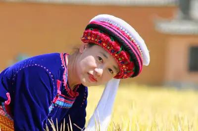
Local Tibetans chatted with us happily, put their arms around our shoulders for photos—happiness came easily and naturally.
Litang Genie South Route: Genie Holy Mountain and the Eye of Genie, 188 kilometers.
Heading to the Eye of Genie, navigation couldn't display the route, and we encountered multiple unmarked forks in the road. No passersby to ask, so we stopped to inquire.
Rocks and rubble covered the mountainside.
First, we passed by the White Dagoba Park. The gate was closed. On the way back in the afternoon, we passed it again and saw a note on the door saying 'open door, pull wire'. So you could enter, but you had to close the door behind you. Inside the park, 119 small stupas surround the main stupa, forming a unique pagoda forest, each representing one of the 119 villages in the county. The main stupa is 33 meters high, the small ones 2.5 meters, and there are also large prayer wheels. Against the blue sky, it looked magnificent.
Genie in autumn: pure sky, golden grass, emerald water, and colorful forests covering the slopes—a vast scenic area.
The yaks also had their own charm.
The monastery and white stupa at the foot of the mountain.
The full panorama of the Eye of Genie can only be captured with a drone; from above it looks just like an eye.
A small pond nearby, the photos of it were no less impressive than the Eye of Genie.
After photographing the Eye of Genie, we headed down a dirt road to a village, with a river flowing from the distant snowy mountains.
A hot spring, where Tibetans were soaking their feet.
On to Xiangcheng, bypassing the hugely popular Daocheng Yading, scenery all the way, covering 285 kilometers.
Rila Monastery, with its red, blue, and white outer walls, belongs to the Sakya sect. A monk from the monastery showed us around; he had been studying there for three years, tall and slender, with handsome features.
The road to Daocheng Yading is excellently built, with signs all along the way, so you won't miss any scenic spots.
Rabbit Mountain, with its peculiar shape: atop a barren peak stand two rocks that resemble rabbit ears.
Shihe Park features ancient glacial landforms—thousands of glacial erratics in all sizes, a spectacular sight.
The red grass field at Sangdui in Daocheng, not large—just about the size of one or two basketball courts. The red aquatic plants and the yellow leaves in the distance set each other off, forming a unique scenic line.
After crossing several mountains, we were surprised and delighted to see these low stone houses. Later we learned they were temporary shelters built by local Tibetans who come to dig for caterpillar fungus; they leave after the season and return the next year.
Entering Xiangcheng, the white Tibetan houses along both sides of the river are renowned as 'White Houses'.
White Tibetan villages nestled by mountains and water. On a clear day, the valley resembles terraced fields, dotted with white houses that look casual and natural.
The east gate of Sangpiling Monastery. The gate pillars are two whole logs carved in the round, depicting the Tibetan auspicious emblem 'Four Harmonious Friends'—an elephant, a monkey, a rabbit, and a bird. The door lintel is carved with four precious beasts: tiger, lion, garuda, and dragon.
Sangpiling Monastery is filled with exquisite carvings and paintings everywhere. Countless figures of Buddhas, birds, and beasts appear in all manner of poses. On column capitals, beams, and corridor ceilings are depicted various auspicious patterns common in Tibetan Buddhism.
Zhongde Village in Qingde Township of Xiangcheng County, where the movie 'I Belonged to You' was filmed. The prayer flag lane and the broadcast station all appeared.
Artistically rich homestay.
Ranwu Township hot spring; after soaking, the whole body felt smooth and comfortable.
Leaving Xiangcheng County in Sichuan and heading southeast, we traveled a roughly 100-kilometer stretch of a great rift valley not yet named on maps (temporary roadside sign Z001), covering 257 kilometers.
From Xiangcheng to Shangri-La in Diqing, Yunnan, we took a newly built road, accompanied all the way by a jade-green river.
Sechong Bridge: We drove across and then took a zigzag mountain road. The mountains were steep, and my foot got sore from driving.
Entering Napahai Lake, snowy peaks reflected in the water; alpine pastures at the foot of the mountains with herds of yaks and sheep presented a beautiful pastoral picture.
A long-established restaurant serving free-range chicken soup, doing a roaring trade.
From Shangri-La town to Baishuitai, then on to Tiger Leaping Gorge Town by evening. Because the Shangri-La–Tiger Leaping Gorge road was under full-scale construction, we couldn't take photos of the scenery except at Baishuitai, mostly dodging potholes and eating dust, covering 198 kilometers.
Taking the Shangri-La East Loop to the Baishuitai scenic area, the route goes up on the left and down on the right. Around the pure, creamy-white Baishuitai, the terraces layer upon layer like a fairyland jade pool.
The road from Baishuitai to Tiger Leaping Gorge was under construction, muddy and bumpy, with steep cliffs on one side and the need to let oncoming vehicles pass. We were fortunate to reach the hotel safely, considering the road was closed the very next day.
From Tiger Leaping Gorge Town, bypassing Lijiang, we decided on a whim to go to Shaxi Ancient Town. After crossing Jianchuan County and heading into the mountains for about 30 kilometers, we reached Shaxi, covering 115 kilometers.
The Gongxili Hotel next to National Highway 214, quaint and elegant.
Lunch at Tiger Leaping Gorge.
The view from the restaurant window.
Checked in at Shaxi Ancient Town.
Ancient lanes, ancient village gates, ancient temples, ancient stages, ancient bridges—in addition to these cultural sights, with the century-old trees beside the horse inn and the lazy sofas outside the guesthouse, time seemed to stand still.
The ancient town's cuisine suited our palate. It was mushroom season, so we bought some mushroom oil as gifts to take back.
From Jianchuan we rushed back to Guangdong. Looking back on the entire journey, two people and one car traveled 18,000 kilometers over 57 days. For every trip, the most important thing is to feel it with your heart. The most beautiful National Highway 317 and the supremely tempting Highway 219 still bring vivid excitement to mind; sometimes when we see landscapes on the TV screen that look familiar, we can proudly comment on them. Very much looking forward to the next departure—the scenery is always on the road.
Travelogue Contents:
1. Day 40: Ruoqiang to Mangya
2. Day 41: Mangya to Golmud
3. Day 42: Golmud
4. Day 43: Golmud to Maqin
5. Day 44: Maqin to Seda
6. Day 45: Seda to Xinlong
7. Day 46: Xinlong to Litang
8. Day 47: Litang
9. Day 48: Litang to Xiangcheng
10. Day 49: Xiangcheng
11. Day 50: Xiangcheng to Shangri-La
12. Day 51: Shangri-La to Tiger Leaping Gorge
13. Day 52: Tiger Leaping Gorge to Jianchuan Shaxi Ancient Town
14. Day 53: Jianchuan Shaxi Ancient Town
15. Goodbye
Travel Information Hotel Index Guide Index Air Ticket Index Website Navigation Travel Index Cruise Index Business Travel Index Join Cooperation Distribution Alliance Friendly Links Enterprise Gift Card Procurement Insurance Agent Agent Cooperation Hotel Join Destination and Scenic Area Cooperation More Join Cooperation About Ctrip About Ctrip Ctrip Hot Topics Contact Us Careers User Agreement Privacy Policy Business License Security Center Ctrip Content Center Intellectual Property Trip.com Group Algorithm Disclosure