The Ultimate Guide to Hiking Qingliang Peak
In November 2020, there was an outdoor hiking event co-organized by the Provincial Sports Bureau and Forestry Bureau, called 'Hike Zhejiang's 11 Summits.' The idea was that 11 mountaineering teams from all 11 regions of Zhejiang would simultaneously summit the highest peak in each region. I was busy with work at the time, but I discovered the event through the WeChat Moments of the captain of the Changshan mountaineering team, because Quzhou's highest peak, Dalonggang, is located right where I work. That gave me the idea to find an opportunity to climb all 11 peaks myself.
I had climbed Zhejiang's highest peak, Huangmao Peak in Lishui, back in 2009. It was an easy round trip of about 3 hours. Dalonggang sits above Hongyanding, and I'd been there twice already. So my first target was the hardest one—Qingliang Peak. I did a ton of research and planning, but I was still nervous. Usually on weekends I hike for 3 to 5 hours and cover 5 to 8 km, but this time it would take 13 hours, 18 km, with an elevation gain and loss of 1200 meters. I was afraid my legs wouldn't hold up. Online information showed many routes up Qingliang Peak, and people frequently got lost. On February 20th, the Super Club official account reported that a hiker surnamed Yang from Hangzhou got lost while climbing Qingliang Peak alone on the second day of the Lunar New Year and had to be rescued. There had even been deaths from getting lost before—pretty terrifying.
I couldn't find anyone to join me in any hiking WeChat groups or online, so in the end I decided to go solo.
For the route, I wanted to take the official route recommended online, starting from Longtang Protection Station and returning the same way—safety first, after all.
On February 22nd, after driving over three hours, I asked for directions in Baiguo Village. A villager said I was heading the right way, but that I could only go halfway up the mountain and wasn't allowed to go further. Plus there was no accommodation near Longtang, so I went with my backup plan: the Yinyilongwu loop. This is the most frequently mentioned route from the Zhejiang side online.
I checked into the Shimensia Grand Hotel in Yinyilongwu just as it was getting dark. I asked the hotel staff if there was a group staying there that was going to climb Qingliang Peak. They said there was a group, but they had just come from the Huihang Ancient Trail and weren't heading to Qingliang Peak. The staff didn't know the mountain route either, and hiring a guide would cost at least 300 yuan. Forget it. I went back to my online research, found a nice topographic route map, downloaded and saved it, and also downloaded two satellite map apps.
I set my alarm for 5:00, planning to head out at 5:30. But at 5:30 it was still pitch black. I went outside and then went back to my room, waiting until 6:00 when the sky began to brighten a little, then I slipped out over the wall. Here's a detailed account of the whole journey with photos, to share with fellow hikers.
6:00, temperature 6°C. Start point: the bridge at the Qingliang Peak Farmhouse in Yinyilongwu. Any of the three bridges in Yinyilongwu will work; the key is to find the next point, the Yinyilongwu Water Supply Station.
6:10, Yinyilongwu Water Supply Station, a white building at the highest point of the village. Head up along the 50 cm wide concrete path, passing through a hickory grove.
6:25, just after daybreak, 1.25 km in, first rest stop. Here you'll see a sign forbidding entry to the mountain. When you see that sign, you know you're on the right track.
From there all the way to the summit, it's entirely uphill, and until the loop back, there's only one path. Just follow the footsteps of those before you—my earlier worries were unnecessary. That's why this is the most perfect route.
6:25, it's light now. I took off some layers and headed up. The first hundred meters are extremely steep, threading through dense forest, crossing a stream, then slanting right through a fir forest to the first ridge line. Soaked in sweat, second rest stop. Elevation 986 m.
7:25, sunrise. Follow the ridge up for over 200 meters to a small platform.
Then traverse right for about 1.5 km, through many ancient pines, the sound of the wind in the pines roaring. Move through quickly.
Here you have to scramble down.
Cross a mountain stream, push through a 30-meter stretch of arrow bamboo, and reach a valley—looks like the upper reaches of Eighteen Dragon Pools from the direction.
Cross the stream, elevation gradually rises, at 1218 m there's a spring by the trail, likely the source of the Eighteen Dragon Pools. Go up fifty meters to a saddle, just catching the sunlight. 8:15, third rest stop. Elevation 1400 m, distance 6 km.
Opposite this saddle is Dong’ao Tou.
From the saddle upward, the path is paved with mountain stone, an official route that overlaps with the one coming up from Longtang Temple.
By the trail are protection signs for clusters of ancient Magnolia sieboldii and Southern Hemlock trees.
9:00, arrived at Dragon Pool, rested briefly.
Above Dragon Pool is the Flower Meadow Maze.
A gently sloping ridge, walking through an ancient forest.
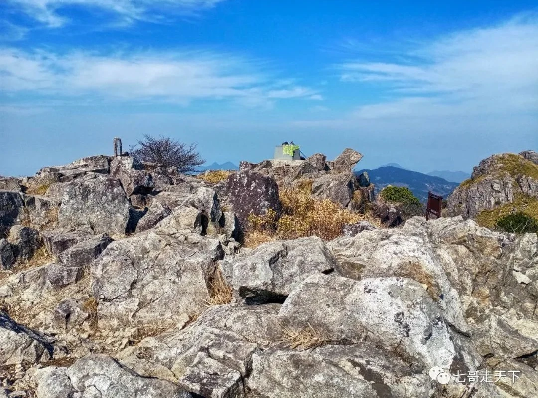
9:37, reached the first scenic spot, Sunning Boot Rock, elevation 1614 m, distance 8.59 km. Fifth rest stop.
The ridge opposite is the one I'll descend later. Side view of Despair Slope.
Go up to Wanxiang Rock. 730 meters left to the summit.
The summit is getting closer, closer.
10:00, summit push. Elevation 1787.14 m, distance 9.7 km.
Start descending at 11:00. Be sure to climb the stone formations on the opposite ridge, otherwise you'll miss the hidden Divine Seal Rock behind them—not difficult, not dangerous.
The valley on the Anhui side.
Now let me describe Despair Slope in earnest.
A 70-degree slope of sand and gravel, with Solomon's seal bushes to the east and grass to the west. Just walk through the grass.
Below Despair Slope are many dead pines.
The saddle below Despair Slope, elevation 1706 m, distance 10.94 km.
Then back up again, through Solomon's seal bushes, to a three-way junction? Southeast looks like it comes from the Anhui direction.
A panoramic view of the original ascent ridge on the opposite side.
Then up and down again to the ridge, Bali Rock? Sixth rest stop at elevation 1613 m. Continue through ancient pine forest—this section is very pleasant to walk, and friends who like climbing trees for photos can have a field day.
Arrive at Taiping Peak, elevation 1403 m, distance 14.32 km, seventh rest stop. I leaned against a large oak tree and sat for a full 20 minutes. The front desk of Shimensia Hotel called to check on me, which was very considerate. You must rest here, because further down it's all steep slopes with no sitting spots.
From Taiping Peak down to Yaojiang? The elevation drops 300 meters, all steep slopes—even more despairing than Despair Slope, a serious test for your knees.
Conservation Area Marker No. 25, elevation 1306 m, distance 16.25 km. Drop to the side, then slant up halfway down the hill. Then another steep straight drop to Yaojiang.
The crucial moment, the key point. Conservation Area Marker No. 24, elevation 1125 m, distance 17.14 km. A small saddle. To the left is a path that continues straight—it probably leads to Zhechuan. From Zhechuan, it's a long way back to the Shimensia Hotel. Here, my mountain instincts really shined. On the map, the hotel was only 500 meters away in a straight line, with a 500-meter elevation difference. Based on experience, I felt there should be a way down to the right, so I probed downward and sure enough, there was.
Less than twenty meters down, I spotted trail markers left by outdoor groups—that was a huge relief. A bit further down, there were fields that hadn't been cultivated in years. Where there are fields, there are paths. There were hickory groves too. This section drops straight down to Eighteen Dragon Pools, with a slope of over 45 degrees, a path less than a foot wide, zigzagging repeatedly, covered in fir needles and thorns—clearly not used in a long time. Judging by the trail markers, at least five or six outdoor groups had passed this way.
Remember this three-branched vine.
Reach the valley floor, above Dragon Gate in Eighteen Dragon Pools. The white building opposite is the Qingliang Clubhouse.
With that, the Qingliang Peak loop was completed perfectly. It was exactly 3:00 PM, taking 9 hours total—4 hours up and 4 hours down, with an hour for photos at the summit. Distance: 18.15 km. I paused my tracking app during the first rest stop, so about half a kilometer wasn't recorded.
This route really is the most perfect. First, it's safe: there's only one path up and down, you won't go wrong or get lost. Second, it saves time and energy. If you go the opposite way, the 3 km below Taiping Peak and Despair Slope are terribly exhausting, with extra ups and downs in between—it would add at least an hour and a half. Third, it drops straight down to Eighteen Dragon Pools, and if you have energy to spare, you can visit them.
The key point here is Marker No. 24—you must remember it.
Since it was still early and I had energy left, I went up to explore Eighteen Dragon Pools. Here are some photos to enjoy. The Eighteen Dragon Pools are stunningly beautiful; in summer, river trekking there must be amazing. Photographers who love shooting water will surely capture breathtaking images.


