Entering Tibet via National Highway 109
On June 19, we set off from Beijing, bound for Lhasa. We took National Highway 109 on the way up and Highway 318 on the way back, returning to Beijing on July 5. The journey took 17 days and covered 9,000 kilometers. Day 1: Leaving Beijing, we drove G5-G55-S50 and stayed overnight in Yulin. We sampled local specialties like cured pork roujiamo, shredded potato 'caca' (洋芋擦擦), rice noodle sheets, and milk tea. I especially loved the caca — steamed shredded potatoes dipped in garlic puree, absolutely irresistible.
Day 2: Heading toward Yan'an, we passed Tongwan City and joined G20, then drove through Dingbian, Anbian, and Jingbian towards Lanzhou. The vast desert landscape unfolded — endless skies and boundless wilderness. We stayed by the Huangshui River in Xining, where rapeseed flowers were just starting to show yellow. For dinner, the firecracker noodles were quite distinctive.
Day 3: We passed Qinghai Lake on the way to Golmud. The rapeseed flowers near the lake were in full bloom. After leaving the lake, snow-capped mountains came into view along the road — majestic distant peaks and sweeping valleys filled our eyes. The drive from Beijing to Golmud totalled 2,510 kilometres, over two hundred less than the Beijing-Tibet Highway, and the scenery was even better. Golmud lies deep in the Qinghai-Tibet Plateau, where the northern foothills of the Tanggula Mountains extend. The average elevation is around 2,800 metres. Traditionally, travellers from the lowlands would rest here for a few days to acclimatise to the thin air. We checked into the Everest Mansion. Golmud's lamb soup pulled noodles were wonderfully flavourful and enticing.
Day 4: We planned to visit Qarhan Salt Lake, but heavy rain prevented it. It's China's largest salt lake, with over three thousand workers and a salt lake museum — we'll save it for next time. Day 5: We set off at 3 a.m. in pitch darkness. Turning on our Nissan X-Trail's roof-mounted spotlights, two beams of light sliced through the night as we drove along the empty highway towards Lhasa. Starting so early was to reach Lhasa the same day. Before the trip, seasoned backpackers had kindly warned us to avoid staying overnight in Nagqu if possible — altitude sickness could sap your energy for the whole journey. Nagqu sits at about 4,500 metres; most people get altitude sickness, and it worsens if you stay overnight. If you get severe altitude sickness in Nagqu, don't even think of driving on to Ngari. Apart from the rough roads, the altitude challenge there is beyond what ordinary people can bear. Driving for days above 4,000 metres requires serious mental preparation. From Golmud to Lhasa is nearly 1,200 kilometres; with speed limits, we estimated at least 20 hours. At 4 a.m. we reached the Nanshankou traffic police checkpoint, got our road permit slip with a time lock to the next checkpoint: 475 kilometres, minimum 7 hours. Once on the road, we found the surface excellent and traffic sparse. Before we knew it, we were cruising at over 100 km/h. Luckily, the scenery was so stunning we stopped often to take it in, so there was no need to deliberately wait. A few kilometres before each checkpoint, you'd often see cars pulled over, waiting out the time. Speeding penalties were severe: a few minutes over and you'd be made to wait at the checkpoint; more than that could mean fines up to 2,000 yuan. Speed limits ranged from 50 to 70 km/h, but there were no radar guns — they calculated point-to-point time.
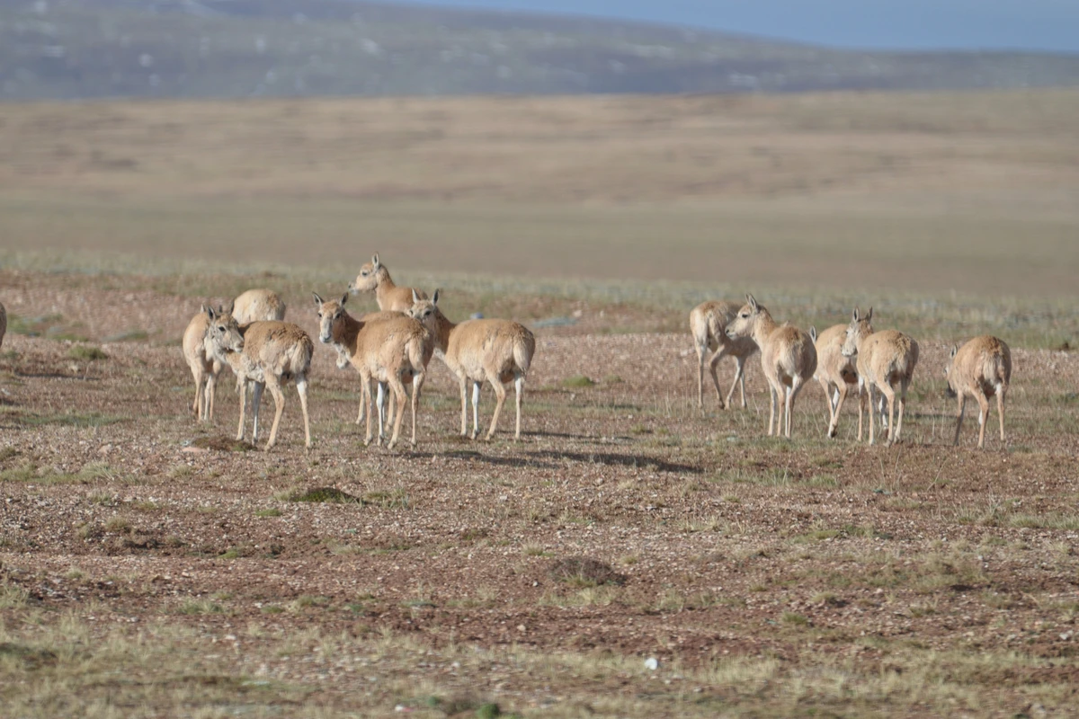
Soon after leaving Golmud, we saw snow peaks in the early dawn — a thousand miles of vast, boundless desert. By Yuzhu Peak, the sky brightened; the temperature was minus 5°C. Opposite stood a Kunlun Mountain water plant. At Kunlun Pass, it was minus 1°C. We entered the Sanjiangyuan Nature Reserve, Kekexili region. The route was one snow-capped ridge after another, with delightful surprises of wildlife. This is what 'the scenery is on the road' means — if you feel your spirit set free, it's worth it. We spotted a herd of Tibetan antelope. Thanks to strict protection, they no longer shy away from people; you can gaze at them from a distance and calmly take photos. We also saw a few solitary male antelope. Why were they living alone? Were they losers in the mating battles? In Kekexili, we also saw wild asses, which locals call 'wild horses' — they did seem larger than the donkeys we're used to. It was a small group, eight to ten animals typical of a wild ass herd, likely including one adult male. At 10:30 we crossed Fenghuo Mountain Pass, then refuelled at Tuotuo River, at 4,700 metres altitude. My feet felt like they were stepping on cotton. At 12:20 we crossed Tongtian River, and at 12:40 reached Yanshiping — 100 minutes later than the speed limit allowed. The weather was fickle: rain mixed with snow and small hailstones.
Passing the Tanggula Military Depot, at 17:00 we swapped our road permit at Amdo checkpoint. By evening we reached Nagqu, and altitude sickness grew worse — a splitting headache and stiff neck. The joy of the road turned to agony. I tried Tibetan saffron, oxygen-boosting medicines, and oxygen inhalation; nothing worked as well as painkillers. We pressed on, changing speed limit slips and getting stamps along the way. Nagqu is a transport hub, with many heavy trucks and roadworks, so we couldn't reach Lhasa that day. We arrived at 2 a.m. the next morning and checked into Ji Hotel. From Beijing to Lhasa, we'd covered 3,670 kilometres, averaging 7.6 litres per 100 km — pretty fuel-efficient for a 2.5-litre engine.
Day 6: In the morning, I wanted to sleep in, but the headache kept me awake. Altitude sickness was there but bearable; later it proved that just pushing through works. In the morning, we visited the Potala Palace; in the afternoon, the Jokhang Temple and Barkhor Street. At a Tibetan-style tea house on Barkhor Street, I drank milk tea — a thermos of around 500 ml for 3 yuan. I had two flasks. It was tasty, affordable, and seemed to ease the altitude sickness; leaving the tea house, I felt refreshed and clear-headed.
Day 7: We went to the Tibet Museum and learned two main things: first, Tibetan history evolved independently since the Neolithic, with pottery 5,000 years ago and a Bronze Age culture, but no Iron Age; second, since the Yuan dynasty, Tibet was administratively subordinate to the central government and increasingly influenced by the Central Plains. Research also shows Buddhism entered Tibet earlier than the Central Plains. The two exhibited treasures from the museum's collection: one is a gold mask only 0.1 mm thick, assembled from two parts — crown and cheek — dating from a 2nd-century tomb; the other is a conjoined pottery jar, utterly different in form from those of the Central Plains, a representative artefact of the Neolithic Karuo culture. In the afternoon, we had a look at Tibet University, Norbulingka, and the Lhasa River.
Day 8: We headed to Nyingchi, beginning the return route on Highway 318 (the southern Sichuan-Tibet route; compared to the northern route on Highway 317, it's much easier — wider roads, lower average altitude, and better maintained). The distance to Nyingchi is 300 kilometres. There were roadworks in Lhasa, and we missed the checkpoint. At the Nyingchi checkpoint, trouble: despite repeatedly explaining we hadn't seen where to get the permit slip, two other cars had the same problem, and we lost an hour before being let through. Day 9: We went to the Yarlung Tsangpo Grand Canyon, driving through the Nyang River scenic area (70 yuan entrance). We drove along the Nyang River sightseeing belt, taking a car ferry (60 yuan per car), and reached the grand canyon by noon — the ticket plus sightseeing bus cost 240 yuan per person. Both the Nyang River belt and the canyon had stunning scenery (see photos below), but Namcha Barwa Peak was hidden in clouds and mist, hard to see. At 5 p.m. we left the scenic area and headed straight back to Nyingchi. On the way, we bumped into a Tibetan fragrant pig. From the speed it bolted, it seemed only frightened. I got out to ask, but only one person could speak a little Chinese; they immediately demanded 500 yuan. I said let me see the pig and what damage there was — they replied then it wouldn't be 500 anymore. So I quickly paid and left. When passing through villages, you really must go slow! Tibetan dishes like tsampa, blood sausage, and beef/mutton are generally hard for outsiders to stomach. Fortunately, there are plenty of Chinese restaurants in the towns, though the taste left something to be desired. Once, we entered a Cantonese restaurant that completely overturned the concept of Cantonese cuisine. But the local milk tea and yogurt you could drink every day.
Day 10: We went to Bomê. Because of a landslide at Tongmai, traffic was just restored to one-way after the armed police repaired it: mornings downhill, afternoons uphill. We left Nyingchi at 9 a.m., passed Sela Pass seeing vast fields of highland barley flowers, then Lunan Military Depot. Around noon, we started crossing Tongmai. At 5 p.m., we crossed Tongmai Bridge, finally ending the slow one-way passage through the Tongmai natural barrier. This stretch is the often disaster-stricken throat of Highway 318, with potholed roads splashing mud and water; in places, barely a single car could squeeze through. The armed police were constantly patching things up to keep it open. At one point, a mountain stream had washed away the road, and a makeshift bridge was built to crawl across. That 210 kilometres took nearly 11 hours. On fine days, even micro-vans could manage it, but any rain brought danger. A new Tongmai bridge and tunnel are under construction — soon Tongmai will no longer be a peril. We stayed at Three Primary Colors Hostel.
The advantage of taking Highway 318 is that you can choose to overnight in towns at relatively lower altitudes, reducing the pressure of altitude sickness. It avoids the seven- or eight-hour stretch above 4,000 metres around Amdo and Nagqu on Highway 109. On 318, crossing a mountain pass gives just an hour or so of altitude discomfort — a fleeting experience, not a persistent headache. Day 11: We went to Mêdog, the last county in China to be connected by road. The breakthrough was the Galongla Snow Mountain Tunnel, enabling all-weather traffic. In the past, the winding mountain road was impassable for eight months of the year. The tunnel is over three kilometres long, and the weather is different at either end: from the Bomê side, it was partly cloudy when we entered; coming out on the Mêdog side, we were enveloped in thick fog, with snow and ice piled along the road. The whole way to Mêdog, snow peaks and alpine meadows assaulted our eyes — there was too much to take in.
June 30, Day 12: We left at 9:30 and arrived at Ranwu Lake by 12:30; the weather at the lake wasn't good. At 2:30 we left Ranwu Lake. West of the lake, the route was lined with dense forest; east of it, the land was more barren. We reached Baxoi by evening and checked into Blue Lake Posthouse. That day's drive was 230 kilometres. Day 13: After refuelling in the morning (2 yuan per litre more expensive than Beijing), we set off. An hour later, we crossed Nujiang Bridge, where traffic alternates in single file. Then we passed Yela Pass and drove the famous 72-turn Heavenly Road. At 3 p.m. we reached Dongda Pass, and rain began. We climbed Jueba Mountain, then Zongba Mountain, and continued through Markam along the red waters of the Xiqu River. In the evening, we crossed Jinsha River Bridge into Sichuan and stayed at Batang Ba'an Impression Hotel, having driven 460 kilometres that day.
Day 14: We left Batang, passing through several tunnels several kilometres long, which reduced the winding mountain roads — the highway grade has improved. This section had countless mountains and curves; even the driver felt dizzy. We entered a highland meadow stretching for a hundred kilometres. The grasslands were covered with wildflowers, dotted with yak-hair tents and grazing yaks. Warm local herder children waved and smiled, making us linger. At 5 p.m. we crossed Yajiang and stayed at Kangding Pangzhaxi Tibetan-style Inn, with our window overlooking the Zheduo River. Listening to the roar of the rapids, we fell into a deep sleep. That day we drove 460 kilometres.
Day 15: In the rain, we got on the Beijing-Kunming Expressway at Shimian; by this point, our average fuel consumption was 7.8 litres per 100 km. We stayed in Mianyang. Day 16: Overnight in Jiexiu. Day 17: Back in Beijing. The total trip averaged 8.2 litres per 100 km.
Highway 109 — vast skies, long roads, magnificent scenery.


