To the Pure Roof of the World: Untamed Tibet (An Ultra-Detailed Self-Drive Guide)
Tibet, Here I Come
"Tibet" – two characters that hold a special meaning, a pilgrimage to the faith within, or perhaps a yearning of the soul. My thoughts pull me back nine years, when I boarded a 48-hour green train into Tibet. Back then, there was no WeChat, no live streaming. Among the sea of people all wearing outdoor jackets, I was the only girl in a dress, crossing mountains and valleys. The most unforgettable memory is surely that Milky Way suspended in the ink-black sky, its circular halo so vivid I felt I could touch it, stars opening misty eyes, shimmering with a watery light. That vast image captivated my gaze; I stood there staring at the heavens. Of course, the memories also include unsettling elements – altitude sickness symptoms, intense headaches.
Preparing to return to Tibet nine years later, that's exactly what worried me most. Painkillers and oxygen canisters, both essential. Once my anxious heart settled a little, we made a bold decision: self-drive. Why bold? Because of the altitude, and the road conditions. Places like Pumo Yumco at 5,200 meters, and the need to bump along dirt roads to reach the Sacred Elephant Trunk Hill (Shengxiang Tianmen). At one point, the 40 Glacier was even on our backup list. You see, the 40 Glacier lies on the border; getting there requires crossing mountains and streams with no GPS signal. If you get lost or stuck, you have to self-rescue, and your whole trip could be ruined in an instant. In the end, time forced us to drop it. Besides the worry of high-altitude driving, the other concern was that it was just two of us and one car. And I don't drive, so Mr. Mo would be the only driver. No convoy, no backup. So Mr. Mo's physical condition became the backbone of the entire journey. And I was his emotional pillar. Both of us were pillars.
Tibet Itinerary:
D1 Golmud Airport–Lhasa, then straight to Yamdrok Lake
D2 Full-day loop around Yamdrok Lake
D3 Pumo Yumco
D4 Lhasa Barkhor Street, Namtso
D5 Sacred Elephant Trunk Hill, Northern Tibetan Grasslands
D6 Lhasa – Drak Yerpa Hermitage, Sanga Monastery
D7 Lhasa – Nanshan Park
First, a sneak-peek video – please, please do turn on the sound.
Pumo Yumco
Yamdrok Lake and Namtso
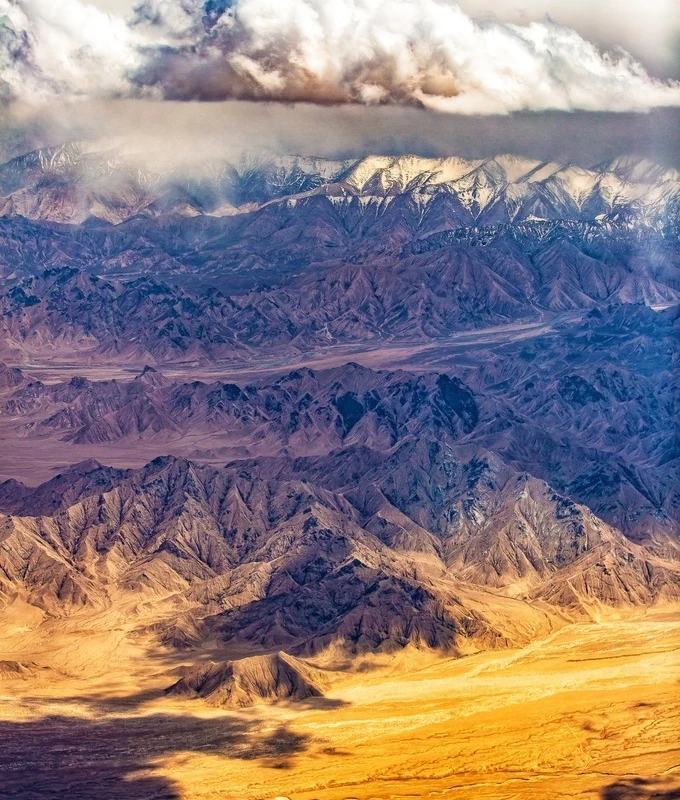
Aerial views of the earth's veins
After spending the previous week in western Gansu and Qinghai, we chose to fly from Golmud Airport, crossing the Qinghai-Tibet Plateau directly to Lhasa. The scenery along this flight path is the most beautiful I've ever seen from a plane. From the Kunlun Mountains to the Nagqu Plateau, snow peaks scattered below, overlooking the earth's veins all the way.
Night One: 4,500 Meters
Yamdrok Lake lies in Lhoka (Shannan), not far from Gongkar Airport. Since our time in Tibet was limited, and it was my second visit, I didn't feel strongly about first warming up in Lhasa as many newcomers do. Instead of detouring to the city, we headed straight for Yamdrok Lake, kicking off our Lhoka journey. Before dusk, as the setting sun slanted, we sped along. Pulling up at a viewing platform, I was distracted by the fierce afternoon wind blowing from the west. After our bumpy journey from Qinghai, we finally felt a hint of fatigue. In the western regions around April and May, sunset doesn't come until after 8:30 p.m. Each night we'd return to town at 9:30 or 10:00, supper becoming dinner, washing up near midnight. Longer daylight hours make for more tiring travel. As darkness approached, we decided to find a guesthouse in Zhama Long Village by the lake. Our preferred place, with huge picture windows and a killer lake view, was under renovation, so we settled for the family-run inn next door. The second-floor room was warmer, but lugging our heavy luggage up the stairs was quite a feat. We had three suitcases; except for one we could leave unpacked, the other two had to go up. After hauling them, we collapsed. Then came the dinner quest: the inn offered only butter tea, no other food, and the entire village had no restaurant. When in Rome, as they say. At least we had instant noodles. I hugged an oxygen canister all night, never sinking into deep sleep. The phone display read 4,500 meters – my first night back in Tibet.
Yamdrok Lake – The Miraculous Blue Ribbon
Early morning, when the first ray of sunlight filtered through the curtain, everything awoke. I eagerly pulled back the drapes: blue sky and white clouds unlocked my heart. On my first visit to Tibet, I passed Yamdrok Lake twice under overcast skies, never seeing her most beautiful face. Today, that wish would finally be fulfilled. The inn sits right on the lakeshore, blessed by geography. Stupas and prayer flags by the lake, herds of yaks grazing on the shore, distant mountains embracing the scene – like a painting. If time could stop, I would linger here until the sun dipped behind the hills.
Leaving the shore, we drove straight up to the Gampa La viewing platform. The panorama from here is so vast it's hailed as the No. 1 Yamdrok viewpoint, truly deserving the title. This time, though, I didn't see Tibetan locals offering photo ops with yaks or mastiffs – not sure why. While soaking in the scenery, I couldn't help but marvel: without these roads, how much time and effort would locals have to expend to come worship the holy lake in the mountains? The best way to repay such beauty is not to waste it.
If from the mountain top you feel the grandeur of landscape, along the shoreline you encounter its graceful charm. Driving east alongside Yamdrok, endless grasslands unrolled, dotted with herds of cattle and sheep, and the lake wove through like a blue silk ribbon, as smooth as satin. If you have the time, please, please don't miss the eastern shore of Yamdrok Lake.
That morning, I danced joyfully after sheep, unaware that a severe bout of altitude sickness was silently creeping up.
Small villages dot the lakeshore, where you can witness authentic Tibetan life and culture. Gongbu Village was the last settlement along the eastern shore loop; from here, we set off toward our next destination: Pumo Yumco.
Night Two: 5,070 Meters
After leaving Yamdrok, the altitude kept climbing, and the scenery gradually shifted from spring to winter. I had lingered so much along the eastern shore, snapping photos at every turn, that we'd used up too much time. By the time we set out for Pumo Yumco, it was already past 4 p.m. Our original plan to loop past Pumo Yumco and return to Yamdrok for the night was no longer feasible; we'd have to overnight at Pumo, and the only accommodation option was Tuiwa Village, the highest settlement at 5,070 meters. Along the way, altitude sickness intensified: low-grade fever, pounding headache, a wave of weakness. Surging to over 5,000 meters on only my second day in Tibet, a restless previous night, the sudden arrival of my period, and the energy I'd spent frolicking with sheep that morning – all the unfavorable factors seemed to combine. The guesthouse sat on a hillside right by Pumo Yumco, easy to spot. Upon arriving, I discovered the toilet was locked. They told us the bathroom in our standard room wasn't functional; we'd have to use the shared pit latrine outside! What?! I felt like I'd explode. Another piece of bad news: no running water either, just a bucket of water provided, and two basins. What?! One basin was labeled "Face," the other "Feet." On top of the washing woes, we had run out of instant noodles. All we had left was a container of fried noodles we'd bought at Gongbu Village that afternoon – stone cold. I gulped it down, swallowing a bellyful of bitterness. The only comfort was an oxygen generator in the room, which was why I'd booked here after calling to confirm. Sleeping at 5,070 meters is no joke. That day, within 24 hours, I popped six headache pills – the maximum dosage on the package.
Pumo Yumco: A Stuck-in-the-Mud Crisis
A heavy snowfall overnight transformed southern Tibet into a scene straight out of the Arctic Circle. Happy? I was. Worried? I was. The uphill dirt track we'd taken to get here now became the knot in our hearts. I finally understood what we should be worrying about. To drive out of the guesthouse successfully, the car had to climb a steep slope, cross a stretch of dirt road, then tackle another steep dirt incline – three obstacles, no small challenge. Let me, a science student, lay out the battle notes:
Section A: a 45-degree cement slope, covered in ice and snow.
Section B: after the slope, about 200 meters of extremely soft dirt road.
Section C: a final 30-degree dirt slope, roughly 100 meters long.
Three vehicles competed – our neighbor teams and us:
Contestant #1: a couple in their fifties from Shanghai, driving a front-wheel-drive Volkswagen.
Contestant #2: a group from Fujian, driving a four-wheel-drive Haval.
Contestant #3: us, driving a four-wheel-drive Volkswagen.
The photo below shows Section B.
Contestant #1, equipped with homemade snow chains, set out first and cleared Section A. But on Section B, the chains broke, and a rear tire sank deep into the mud – game over, rescue needed. The powerful Contestant #2 went next. Without chains, using brute torque, they passed Sections A and B. At Section C, after a few attempts, they drifted and scrambled to the top – victory! Now Contestant #3 was itching to try. First, we charged the icy slope A. One attempt – fail. Two attempts – fail again. The driver began contemplating other tactics, scouting Sections B and C while checking on Contestant #2’s status. Meanwhile, spotting a shovel by the wall, I hatched a grand plan. Summoning all my strength, I chipped away at the ice and snow on Section A bit by bit. After that labor, Contestant #3 smoothly cleared Section A and reached Section B – the very spot where Contestant #2 had gotten stuck. To get out of the soft ground? We tried: one person driving, three pushing. Shovel snow! Push! Good heavens, yesterday I was barely alive, yet under pressure I had risen like a phoenix. Remember, at 5,070 meters, oxygen levels are half that of the plains, and yesterday I'd experienced my worst-ever altitude sickness. Mustering every ounce of energy, we pushed. A few fishtails later, we almost bogged down again. Fail. The only hope might be snow chains. We didn't need a timely gift of coal; we needed a timely gift of chains. Dozens of minutes later, a Tibetan lad from the guesthouse loaned us a set of iron snow chains, and Contestant #3 finally drove smoothly through Sections B and C, onto the wide open road. Yes! Victory! From a dog's-eye view, look back at the road we conquered, wave goodbye to everyone, grateful for their help.
Gloom will pass, and the sun will shine again. By 10 a.m., three hours later than planned, we were free and arrived at the shores of Pumo Yumco. Pumo Yumco lies on the border of Lhozhag and Nagarzê counties in Lhoka, at about 5,010 meters, one of the highest freshwater lakes in the world. Legend says a fairy once waited here for a herder who had helped her; day after day she waited until he finally returned, and they became a couple. But one day, while herding on the mountain, a sudden blizzard froze the herder to death. The grief-stricken fairy wept over his body without pause, and her tears formed "Pumo Yumco," while the herder turned into Mount Kula Kangri. The blue of Pumo Yumco is like a mirror of the sky, set against a backdrop of rolling snowy peaks, the holy sunlight spilling onto the azure surface, sparkling and shimmering.
Night Three: Over Mountains, Back to Lhasa
Leaving Pumo Yumco, we passed a roadside monastery. Our next stop was originally further east – to Zeku Grassland and Yumbulagang. But after returning to Gongbu Village, the navigation directed us onto a dirt track. Only by following tire tracks could we hope to reach Zeku Grassland. Several uncertainties loomed:
1. The weather to the east was poor; if a section got rained on and the tire marks vanished, would we get lost?
2. We didn't know the road conditions; if we hit soft ground and got stuck, we might end up with no rescue in sight.
3. Because of the morning's delay, we might arrive after dark.
The photo below shows the dirt road heading to Zeku Grassland. I should note: we used both AutoNavi and Baidu Maps; Baidu showed this route, AutoNavi did not. I advise self-drivers when planning to cross-check with different navigation apps to see if a route is viable.
After discussing, we decided to abandon the rest of our Lhoka trip and head back to Lhasa. That day, after so many twists and turns, we faced the winding mountain roads with no fear left.
On the return journey over the mountains, we passed an unnamed glacier. Approaching Lhasa, the altitude dropped sharply, and spring burst forth in full bloom. Passing through Gongkar, we grabbed dinner and reached Lhasa near midnight, dragging our exhausted bodies, breathing freely in the low altitude. Night three: Lhasa, 3,500 meters.
Barkhor Street, We're Back
At last I could feel the joy and hardship in the song "Back to Lhasa." A day to sleep in, we headed to Barkhor Street. In Tibetan, "Barkhor" means "middle circumambulation circuit." Also known as Bajiao Street, it sits in the old quarter of Lhasa, a renowned pilgrimage circuit and commercial hub, perfectly preserving the city's ancient face and lifestyle. Originally, Barkhor was simply the kora around the Jokhang Temple, called the "Sacred Road" by Tibetans. In the hearts of Tibetan people, the Barkhor kora is the most important one, meaning "middle circle" in contrast to the "Lingkor" (outer circle) and the "Nangkhor" (inner circle) inside the Jokhang. As the specific time for evening circumambulation arrives, strangers – some in white robes from the northern pastoral areas, some with hero knots from Kham, others in bright local dress – strictly follow the clockwise direction along this circular path. During the pandemic, the Barkhor kora had just reopened.
The yellow building housing Lhasa's "Makye Ame" bar is said to be where the sixth Dalai Lama, Tsangyang Gyatso, met the maiden Makye Ame. Here he composed the famous poem "On That High Eastern Peak": "On that high eastern mountain top, rises a bright, pure moon; the face of a young unmarried girl, constantly appears before my eyes." "Unmarried girl" in Tibetan is "Makye Ame."
Namtso, the Most Beautiful Sacred Lake of the Snowlands
After Barkhor Street, we drove from Lhasa to Namtso. The road takes you past Yangbajain, famous for its rich geothermal resources, hot springs, and power generation, then into Damxung County before turning left onto the winding mountain road up to Namtso. Namtso is hailed as one of Tibet's three great sacred lakes. It and the Nyainqêntanglha Mountains belong to an ancient legend as yin and yang; it's not only one of the world's highest large lakes, but also the source of many mysterious tales.
The Nyainqêntanglha viewing platform we passed is a perfect spot to admire the 7,711-meter Nyainqêntanglha peak. A giant mani stone pile stands there, colorful prayer flags fluttering all around. Legend says Nyainqêntanglha and Namtso were a devoted couple, living together on the beautiful northern Tibetan plateau, inseparable. One day, while searching for lost livestock, Nyainqêntanglha wandered to another pasture and met the stunningly beautiful girl Yamdrok (the lake) and fell helplessly in love, forgetting everything – including his wife Namtso waiting at home. Namtso, thinking her husband had met danger, wept day and night, eventually turning into a clear lake. As days passed, Nyainqêntanglha suddenly remembered his wife. Guilty and desperate, he rushed home to find the lake that was Namtso. Remorse and self-blame kept him standing sleepless by the shore, and he transformed into a handsome snowy mountain, guarding her forever. And lonely Yamdrok also became the captivating Yamdrok Lake. This viewpoint is the Nyainqêntanglha observation deck.
From the Namtso scenic area gate, it takes at least one and a half hours to reach the lake, crossing the Nagenla Pass. The sheer distance made the novice off-road driver groan. I clearly remember Namtso in late June: crystal clear, the lake surface a sky-blue mirror reflecting the continuous snow peaks on the far shore. But now, at the start of May, the lake hadn't fully thawed. Yet the streams near the shore flowed a startlingly translucent blue. With two hours until sunset, we didn't have ample time if we wanted to drive back safely to Damxung before dark. Just then, a young Tibetan man followed us, calling out to win his last business of the day – horseback riding. Two horses stood in a stable, one pure white and strikingly beautiful. I asked to ride that fine steed, but the young man shook his head – it wasn't his horse, couldn't do it. He pointed to two distant horses: those were his. We walked over. A grey and a white, small and thin to the point of being pitiful. Somewhat unwillingly, I mounted the little white horse, which took reluctant steps in place. The Tibetan man then pulled out his whip. Oh no! How could he... whip the little horse?! I insisted on dismounting and took the reins from him. Perhaps thanks to my weight being gone, the pony walked lightly. I led him by the reins to graze and drink. That, I thought, was harmony.
Back to the scenery: the lakeside meadows teemed with cattle and sheep, crisscrossed by streams. Against the majestic lake and vast snowy mountains, under the slanting sunlight, it was a living painting. And I had become a horse-herding lass in the picture. Sunlight gradually faded, rim-lighting the flock of sheep.
Night Four: The Sudden Blackout in Damxung
We raced from Namtso back to Damxung and settled into the best hotel in town, prepping for the next day's excursion to the Sacred Elephant Trunk Hill. Damxung has several three-star rated hotels, all quite decent – at least they have bathrooms and electric blankets. But for me, having an oxygen-equipped room was my top selection criterion. Sleep, sleep. After tinkering with photos all evening, I finally fell into a dream. … In the pitch darkness, I was jolted awake by the beeping of a drone. Rubbing my eyes, I figured the drone had finished charging. I reached for the lamp switch – huh, why isn't the light turning on? A power cut? I looked out the window: total blackness. I put on my down jacket and went downstairs to call the hostess. Answer: the whole town had lost power. What?! My phone, camera, and drone were all charging! A blackout? The hostess said she'd never experienced this before – a rare event. Camera couldn't charge, electric blanket went cold, oxygen machine stopped. I could only return to my room, console myself, and try to sleep again. We'd booked two nights, but now we quickly packed, making contingency plans. I added the hostess on WeChat. If power came back before evening, I'd stick to our plan and return. If not, goodbye Damxung. Where would we stay? I had no idea. Here's why we needed two nights in Damxung: the next destination, Sacred Elephant Trunk Hill, isn't far as the crow flies, but a section of dirt road means that for a non-local driver, the one-way trip takes 5–6 hours. Setting out at 7:30 a.m., we'd get back to Damxung after dark. Drive all the way to Lhasa? Better not push it. I definitely do not recommend returning to Lhasa the same day from Sacred Elephant Trunk Hill.
Sacred Elephant Trunk Hill: The Ultimate Destination
"Sacred Elephant Trunk Hill." It hides quietly on the north shore of Namtso, gazing across the holy lake at the divine peak of Nyainqêntanglha. This is the secret edge-of-the-world in the hearts of veteran Tibet visitors, the ultimate Tibet landscape. It's named after a small mountain by the lake that resembles an elephant drinking water. The rock formation looks like a giant stone elephant, its trunk dipping into the lake surface as if drawing sacred water from the snowy secret realm. From Damxung to Sacred Elephant Trunk Hill, you still pass through the Namtso scenic toll gate. No need to buy tickets there, but you must tell the staff you're only going to Sacred Elephant Trunk Hill, not Namtso. The staff member carefully photographed our car and warned us that entering the Namtso area would be considered fare dodging. After crossing the Nagenla Pass, there's a fork: left for Namtso scenic area, right for Sacred Elephant Trunk Hill, with another 4 hours to go.
Where do you buy tickets for Sacred Elephant Trunk Hill? As we were puzzling, two Tibetans stopped us with a rope. Strangely, we were told to send our IDs to a specified WeChat number; only after getting confirmation could we pass. Who was on the other end? We had no idea. Provide photos of all our IDs, including driving license? A huge risk of information leaks. Anxiously, I sent the info and got a reply. The Tibetan inspected my phone's feedback, untied the rope, and let us through. Five minutes later, a voice message came via WeChat, asking us to transfer 330 yuan per person for ticket and accommodation. But we weren't planning to stay overnight there! After a long while, another voice message: go buy tickets at the scenic area directly. After three and a half more hours on a dirt road, we finally reached the actual ticket booth – 80 yuan per head. That earlier barrier? A trick by villagers to drum up business? Since Sacred Elephant Trunk Hill is a ticketed attraction, I strongly urge the local government to please strengthen supervision.
Hey, I bet you're curious what the dirt road to Sacred Elephant Trunk Hill looks like. A dirt road is at least a road. Many vehicles veered onto adjacent land marked "No Entry," seemingly saving time, but that ground hides sinkholes. Get stuck, and you wait for rescue – haste makes waste. Along the way, we saw several vehicles stuck in mud. We, on the other hand, kept a steady pace on the bumpy but proper route. As we drew closer to the lake, the scenery grew richer. Sacred Elephant Trunk Hill appeared before our eyes: the stone elephant standing on Namtso's shore, the lake surface still partly iced and pure white, shining under the sigh of ages, quietly recounting the world's gentle stories in this remote corner.
Spring Across the Northern Tibetan Grasslands
Returning from Sacred Elephant Trunk Hill to Damxung meant retracing the morning's ordeal. Hours later, when we again passed the Namtso villages, the setting sun had bathed the grasslands and lake in gold. We stopped, wandering among the houses and herds, soaking in the simple spring of the northern Tibetan plateau. One stray little baa-baa sheep, drawn by us, came over curiously. It was plump and round, with a tiny head, just like the adorable lamb from a commercial. That thick wool looked like it could be knitted into a whole sweater.
South of Namtso rise the perpetually snow-capped Nyainqêntanglha Mountains; north and west lie highland hills and a vast lakeshore. To the southeast is the main peak, piercing the clouds and eternal snow; northwards, gentle rolling highlands lean against the lake. Grasslands encircle the lake on all sides; the heavenly lake is a giant precious mirror set into the northern Tibetan steppe. In pilgrims' hearts, Namtso is a sacred site. In legend, Namtso is the daughter of Indra and wife of Nyainqêntanglha. Devout believers consider it a must-visit holy place, with endless streams of worshippers since ancient times. The five islets in the lake are considered incarnations of the Five Dhyani Buddhas; anyone coming to pay homage prostrates in reverence. It's said that in the Tibetan Year of the Sheep, all Buddhas, Bodhisattvas, and dharma protectors assemble at Namtso for a great ceremony. Circumambulating the lake and chanting sutras then is worth ten thousand ordinary circumambulations.
Back in Damxung, sure enough, electricity had been restored.
Discovering a Hidden Celestial Temple, Lhasa
Because of the pandemic, all monasteries in Lhasa city were closed. Ganden Monastery, which I had my heart set on, never answered the phone. I tried my luck, but we were stopped at the foot of the mountain – still not open. With no Plan B, I quickly searched online for temples nearby that were open and found Drak Yerpa Hermitage, which had few reviews but was listed as open. By pure chance, we stumbled into this celestial temple. I'm sure 99% of visitors to Lhasa have never heard of it: Drak Yerpa Hermitage. Hidden on the cliffs, you drive up a winding mountain road, then walk a short way. It's said that normally only locals go, virtually no tourists. Our finding it was serendipitous. Drak Yerpa is a Nyingma (Red Hat) monastery, one of Tibet's four great hermitages, founded in the 7th century with 1,500 years of history. Unlike the surrounding peaks with only a thin layer of grass, Drak Yerpa brims with natural spirit. Cypresses and pines stand upright and lush green; clear springs trickle below. In spring and summer, wildflowers bloom, birds sing. The Drak Yerpa shrines nestle into the cliff face, a unique scene. When visiting, please note you'll pass monks' living quarters; speak softly and don't disturb excessively. No ticket is required, but physical fitness is – there are many steps and the thin air makes it taxing.
Sanga Monastery we passed on the way to Drak Yerpa. It's actually quite beautiful, just little known.
The final Lhasa sight was, naturally, a mandatory visit to the Potala Palace. Shut due to the pandemic, we could only admire and gaze from a distance. Skipping the usual photo spots, we went to the Mirror Lake in Nanshan Park, which perfectly frames the fantastical sight of the Potala reflected on water. We bid farewell to the Potala as our journey's end.
—— Sharing Time ——
Recommended Routes Around Lhasa
🚗 One-Day Yamdrok Lake Loop
Tip 1: Don't just stop at the viewing platform. Reserve at least a full day for the most beautiful blue ribbon – do the eastern shore loop and enjoy grasslands teeming with cattle and sheep beside crystal-clear waters.
Tip 2: I highly recommend staying the night before at Zhama Long Village by Yamdrok Lake. The early morning lakeshore scenery will absolutely stun you. Due to topography, clouds tend to gather around Yamdrok in the afternoon; the lake is clearest and most beautiful in the morning.
Tip 3: Lhasa to Yamdrok one-way by car: about 2.5 hours.
🚗 One-Day Pumo Yumco (or Two Days with 40 Glacier)
Tip 1: For Pumo Yumco only, you can set out from Yamdrok, spend one night at Pumo Yumco, and return to Lhasa the same day. Pumo Yumco is a highland lake in Lhoka; in winter it presents blue ice like Lake Baikal, and even in May as I visited it was a snow-covered fairy-tale world, a purity surpassing even Northern Europe. Highly recommended!
Tip 2: For both Pumo Yumco and the 40 Glacier, you need two days. We didn't visit the 40 Glacier; despite it being May, the snow on the approach was said to be too deep, impassable even for 4WDs.
Tip 3: From the eastern end of Yamdrok at Gongbu Village, it's a 4-hour drive to Pumo Yumco.
🚗 Namtso & Sacred Elephant Trunk Hill (Two and a Half Days)
Tip 1: Lhasa to Namtso takes 5–6 hours. When navigating, set your destination as Tashi Dor Peninsula, not the Namtso Scenic Area gate – that's not the endpoint. From the toll gate to the lake you still have to cross the Nagenla Pass, a 1.5-hour winding drive. From the scenic gate to Tashi Dor, it's about 2.5 hours.
Tip 2: The one-way drive from Namtso to Sacred Elephant Trunk Hill takes 5 hours. I don't advise driving back to Lhasa the same day from Sacred Elephant Trunk Hill to avoid excessive fatigue.
Tip 3: A Namtso ticket is only valid on the day and does not cover Sacred Elephant Trunk Hill; buy that ticket separately on-site.
🚗 Our Route – also the Classic Lhasa Area Circuit
D1 Airport – Yamdrok Lake, overnight at Yamdrok
D2 Yamdrok Eastern Shore – Pumo Yumco, overnight at Pumo Yumco
D3 Pumo Yumco – Lhasa, overnight in Lhasa
D4 Lhasa – Namtso, overnight in Damxung County
D5 Sacred Elephant Trunk Hill, northern Tibetan grasslands, overnight in Damxung
D6 Return to Lhasa
D7 Lhasa
If it's your first time in Tibet, I suggest spending a few days in Lhasa upon arrival to acclimatize.
🚗 6-Day Lhoka In-Depth Mini Loop
If you have 6 days for Lhoka, I highly recommend this in-depth loop:
D1 Lhasa – Samye Monastery, Lhoka Sand Dunes
D2 Samye – Yumbulagang – Zeku Grassland
D3 Zeku Grassland – Kaju Monastery
D4 Kaju Monastery – Pumo Yumco
D5 Pumo Yumco – 40 Glacier – Yamdrok Lake
D6 Yamdrok Eastern Shore – Lhasa
🚗 Which Temples Near Lhasa Are Best for Photography?
Besides the must-visit Potala Palace, Jokhang Temple, and other famous palaces and monasteries, I highly recommend these lesser-known but visually stunning temples:
1. Ganden Monastery – a hilltop monastery on the outskirts of Lhasa, with red-and-white architecture perfect for photography. About 1.5 hours from Lhasa city; plan a full day for photos.
2. Drak Yerpa Hermitage – a cliffside hidden gem, also a meditation retreat for monks, well worth a visit. Not far from Ganden.
3. Samye Monastery – located in Zhanang County, Lhoka, about 2.5 hours' drive from Lhasa. Within its circular "iron enclosing mountain" wall lies the mundane world of sentient beings; the four-colored stupas inside are a photographer's paradise.
🚗 What Glaciers Are Near Lhasa?
1. 40 Glacier – the most stunning glacier near Lhasa. Allow at least two days from Lhasa, but note it's in a border area requiring a frontier permit and often closes without notice. The approach road is rough, requires fording streams, a 4×4 is essential, and snow tires are a must in winter. For safety, travel with at least two vehicles.
2. Kuok Qionggangri – about 3 hours' drive, can be added en route to Namtso. The scenery is less dramatic than 40 Glacier, suitable for a quick photo stop.
3. Karola Glacier – on the southwest side of Yamdrok Lake. However, the ice tongue has retreated dramatically; comparing photos from nine years ago shows a world of difference.
4. Sewu (Sapu) – a glacier among sacred peaks in northern Tibet, very remote, suitable only for in-depth adventurers.
Self-Drive Pitfall Prevention Guide
1. Choose a well-known rental company, even if booking through a large platform. Check the actual rental firm.
2. A 4WD off-road vehicle remains advisable. Weather and road conditions in Tibet are unpredictable – we nearly got stuck at Pumo Yumco, didn't we?
3. Compared to hiring a car with driver, self-driving means less familiarity with road conditions, so always budget extra time in your plans. What locals call a two-hour drive usually takes us three to four.
4. Different map apps can show completely different routes. Pay attention: if navigation directs you onto a village track, double-check with another app. Such tracks might look like the tire marks in the photo. Beware of rain washing marks away, and beware of getting stuck.
My Tips for Coping with Altitude Sickness
I'm not immune to altitude sickness; on the contrary, every trip to the highlands brings mild symptoms. That's precisely why I've compiled some useful (and not-so-useful) methods to share.
1. Altitude sickness relates to your constitution and current physical condition. How well you rest greatly affects its severity.
2. Taking Rhodiola rosea in advance doesn't help much. "Gaoyuan An" can be taken upon arriving in Tibet for the first few days; once you acclimate, I found it not very effective and unnecessary to continue.
3. Feeling short of breath or puffing while walking is normal – no need to panic.
4. Common altitude sickness symptoms: headache, nausea, fatigue. The most effective remedy is painkillers – EVE, Bufferin, Ibuprofen all work. I've had repeated success. But remember, all medicines carry some risk; don't take them unless the headache is severe.
5. Bring along oxygen: oxygen pillows or canisters. Oxygen pillows need to be filled at a hospital and last about 40 minutes per fill. Canisters are convenient, each providing continuous flow for about 20 minutes; used sparingly, they last much longer. You can buy them online and have them delivered to your hotel or rental car company, or buy locally.
6. In Lhasa, I don't recommend staying in an oxygen-enriched room. After all, Lhasa is only 3,700 meters – not that high compared to other places. Use Lhasa as your acclimatization period. Conversely, if you breathe enriched oxygen there, transitioning to higher altitudes will be harder.
Pandemic Travel Precautions
Although the pandemic is currently under control, don't forget we still need to be cautious and prepare properly. Here are essentials for your trip:
1. Masks are indispensable, especially on public transport like planes and trains, and at indoor venues where masks are required. Please cooperate and wear them properly. Also, keep a spare mask in your bag.
2. On public transport, try to sit in your assigned seat and avoid swapping, to avoid causing inconvenience for staff.
3. Download and fill out the destination's health QR code before departure. Remember to fill it out truthfully and accurately. You'll need to show it when entering attractions, hotels, and other public places.
4. Museums, temples, and many indoor sites have gradually reopened but with limited capacity. Be sure to book tickets via their official accounts or websites at least one day in advance to avoid being turned away.
5. Carry alcohol-based hand sanitizer gel. Remember, keeping your hands clean is priority number one.


