2020 Sichuan–Tibet Journey
Tibet has always been a place that many long to visit, with even the saying that 'you must visit Tibet at least once in your lifetime.' A few months ago, we began planning a trip to Tibet. We started gathering knowledge from experienced friends and family, and followed official accounts like 'Xixingbang Tourism' and 'Tibet Traffic Police' on WeChat to help with itinerary planning and real-time road conditions. In mid-July, we learned that the Sichuan-Tibet Highway had been repaired and was open to traffic, so we packed spare food, medicine, emergency supplies, clothes and set off on the 16th.
We left Shunde around 10 a.m. Roads were not too busy, traffic was smooth, and we drove all the way to Sanjiang County in Guangxi before stopping to rest. It was still early, so we wandered around town. The county's central square was built in Dong ethnic style, though simpler than the Dong villages in the countryside.
Day's drive: 610 km. Fuel: 350 yuan, tolls: 355 yuan.
Day 2, we set out early from Sanjiang County, driving northward through Guizhou Province. This expressway had many tunnels, so it took longer than expected. By mid-afternoon, we entered Sichuan and continued to Yibin city for an overnight stop.
Day's drive: 840 km. Fuel: 580 yuan, tolls: 550 yuan.
Today we planned some sightseeing nearby. In the morning, we visited the Wuliangye Distillery in Yibin. As everyone knows, Chinese baijiu often comes with a long, storied history. Wuliangye is a famous Chinese liquor, and details of its origin and cultural history are easy to find online. Visiting the distillery, our first impression was its sheer size – the local airport is even named 'Wuliangye Airport,' which shows its influence! The complex roads allow visitors to drive through and take in the sights. Vehicles streamed in and out, including many trucks carrying raw materials and finished liquor. The air was filled with the pleasant aroma of grain and spirits. Attractions included the Wuliangye Liquor Culture Museum, the Endeavour Pagoda, Pengcheng Square, the Screen Tower, and we could also get close to the earthen pits and fermentation workshops. We took a slow drive along a few routes, snapped photos at some spots, bought some souvenir liquor at the outlet, then left for the next site.
Around noon, we arrived at the Leshan Giant Buddha cruise terminal and took a boat to view the Buddha. I had been here over a year ago, but the site was under maintenance and I couldn't see the full statue, which was a pity. Today I finally got my wish.
The boat sailed slowly on the Min River. From a distance, we could already see the Buddha, and passengers spontaneously went on deck to gaze. When the boat stopped right in front of the Buddha, the captain paused to let us enjoy the view. The Buddha rose as high as the mountain, overlooking the river and us visitors, with the surging Min River below – the overwhelming grandeur was truly stirring. I felt like belting out the tune 'A Laugh on the Sea'!
After admiring the Buddha, we packed up, headed west, and reached Ya'an, the first county town along the Sichuan-Tibet Highway, where we checked into a hotel.
Day's drive: 330 km. tolls: 130 yuan.
Setting off from Ya'an, we drove on the expressway for just over an hour and reached Luding County. Leaving the expressway, we turned onto the national highway, running parallel to the Dadu River. Looking out the window, the river raged with swift currents pounding the mountainsides and rocks, roaring ceaselessly. Following the highway into Luding county, we visited the red tourism site – Luding Bridge. In 1935, the Long March of the Red Army passed through here and fought the famous battle of 'Seizing Luding Bridge' against KMT defenders. The gorge is about a hundred metres wide, the Dadu River rushing below in treacherous torrents. Over the river hang nine thick iron chains, each as big as a rice bowl's rim – that's Luding Bridge. There's a twenty to thirty-metre drop from the chains down to the churning water. Planks were laid over the chains for visitors to walk more easily. Back then, the Red Army commandos stormed this vital strategic point by crawling along the bare chains, advancing and fighting simultaneously. The difficulty and danger were immense! Truly, the victory of the Chinese revolution did not come easily, and we should treasure it.
We walked across Luding Bridge and back, read some historical accounts, then left Luding. Soon we arrived in Kangding. The westbound expressway ended there, and we turned onto the Sichuan-Tibet section of National Highway 318. The road twisted and climbed to Zheduo Mountain at about 4,200 metres above sea level. This is the border between Sichuan's Han and Tibetan areas. At high altitude for the first time, I started feeling some fatigue and shortness of breath. But having climbed Jade Dragon Snow Mountain before, I didn't pay much attention (later proven to be a mistake). We took in the view from the summit, then began descending towards Xinduqiao. The scenery along the way was beautiful: small streams, grasslands, herds of cattle and sheep, Tibetan houses, all blending into a Kangding pastoral scene – every snapshot a masterpiece.
Because altitude sickness hits with a delay, my earlier carelessness on Zheduo Mountain caught up with me when we reached Xinduqiao. I found a guesthouse and rested. Over the next few hours, I felt awful. Luckily, some members of our group weren't badly affected, and one fussed around taking care of us – we were so grateful. By evening, we realized we needed medication; we took corresponding medicines or oxygen depending on symptoms, and soon everyone was feeling better, almost as if we'd gotten over the sickness, and we could rest peacefully. The guesthouse owner was kind; he comforted us, saying newcomers to the plateau often feel this way and not to worry. He also brought us oxygen canisters.
Day's drive: 370 km. Fuel: 440 yuan, tolls: 130 yuan.
We woke with much better spirits, perhaps having adapted somewhat to the altitude. We took a good look around the guesthouse, chatted with the owner. This place is surrounded by mountains, with a monastery not far away. On a distant mountain slope, there was a string of Tibetan Buddhist script seemingly planted with different coloured plants and trimmed into shape – a characteristic we saw on many mountaintops in the following days. The guesthouse owner was also a monk and a council member of the nearby monastery. He had turned his home into a guesthouse. For festivals, villagers and monks gathered here, so his kitchen was huge with lots of tableware.
After breakfast, we left Xinduqiao and continued our journey. All along were high mountains, rivers, flowers, grass, cattle and sheep. The car snaked along National Highway 318, crossing 4,700-metre Kazila Mountain and reaching Litang, the 'High City in the World' (about 4,000 m). After a simple lunch, we drove through high mountain meadows with patches of thin snow. Soon we came to a viewing platform: against the blue sky and distant peaks lay two lakes, almost identical in shape and size, like silver plates or jade mirrors – the Sister Lakes. Farther out, a snowy mountain stood as a jade screen behind them. After lingering a while, we descended all the way to Batang County, the westernmost county in Sichuan on the southern Sichuan-Tibet route.
Day's drive: 350 km. Fuel: 380 yuan, protective supplies like oxygen: 200 yuan.
After studying information the previous night, we decided to cover the planned three-day section from Batang to Nyingchi in two days, which would also help us avoid sleeping at very high altitudes. So we set off very early. Not far out, we encountered roadworks and were held up for about 40 minutes. Half an hour later, we reached the Jinsha River Bridge, the span connecting Sichuan and Tibet. Once across, we were in the Tibet Autonomous Region! The road was treacherous, often squeezing through narrow spaces between steep mountains and rushing rivers, or winding up twisting mountain roads. After climbing each peak, we'd cruise across high-altitude meadows for a while. The rivers that accompanied the road roared fiercely, pounding huge rocks and the banks – spectacular. The rivers flowed now with us, now against us. Later checking the map, we saw we had encountered the Jinsha, Lancang and Nu rivers, each flowing in different directions. We crossed mountains like Jueba and Dongda, all around four to five thousand metres. Above 4,000 metres, the air is thin; just getting out to see the view required slow, gentle movements, and back in the car we needed to breathe calmly before continuing. The engine also struggled, but our vehicle's 2.0T turbo engine delivered strong power once revved, and its safe and comfortable suspension carried us over mountains and steady advances. Amid the danger and beauty, we passed through Mangkam, Bangda, the famous 'Seventy-Two Bends,' and reached Baxoi County by evening.
Day's drive: 470 km. Fuel: 375 yuan, protective supplies like oxygen: 150 yuan.
Upon checking into the hotel last night, we got the news that the road from Tangmai to Nyingchi had collapsed and was closed again – we were almost devastated! This morning at breakfast, we overheard many strangers discussing it. After comparing the estimated closure time with extra time needed for an alternative route, we decided to stick to the original plan. Among mapping apps, Baidu Maps actually showed the road as clear, which boosted our confidence (later proven to be unreliable). We sped off with a sliver of hope. However, when we reached Midui Glacier, all sources confirmed the road was truly closed. So we visited the Midui Glacier scenic area. From the visitor centre, we took a shuttle deep into the area and walked about 2 km to a viewpoint. From there we saw the glacier's full structure: cirque, tongue, streams from melting ice, a lake formed by meltwater, and spruce forests on the higher slopes that support the glacier. Trekking at nearly 4,000 metres, climbing countless steps, we were all breathless and exhausted. But nobody had severe discomfort, which showed we had largely adapted to the altitude.
After the visit, we drove westward. The roadside scenery changed again – gentle roads lined with tall pine trees, and below the distant mountains, barley fields, flower fields, meadows, sheep and farmhouses, as if entering the European countryside. A little further we reached Bomi County, where we stayed overnight, waiting for the road to open.
Day's drive: 220 km. Entrance fees: 260 yuan.
With the road still closed and detours too long, we had to wait in Bomi. In the morning we strolled the streets and bumped into a few tourists from Foshan who were also waiting; we exchanged contacts for future updates. We looked for nearby sights and decided to visit Guxiang Lake.
Guxiang Lake wasn't far. A tributary of the Yarlung Tsangpo River widens here, slowing down, and along with the surrounding hills and flat pine forests, creates a wetland park-like landscape, tranquil and pleasant, a sharp contrast to the high-mountain torrents we'd seen along the way. There were two recreational spots, seemingly recent tourism poverty-alleviation projects, but perhaps due to the pandemic or management issues, the beautiful resort had very few visitors! With our road blocked and time slipping away, we weren't in the best mood to fully appreciate this beauty.
In the afternoon, we returned to the hotel, borrowed some utensils, and bought fresh matsutake mushrooms and meat at the market. Good food instantly lifted our spirits!
Day's drive: 50 km.
Morning: Another stroll around town, buying some local products, then waiting in the hotel for traffic news. After 2 p.m., we learned the armed police had built a bypass next to the landslide, the road was reopened, and single-vehicle passage was allowed. Everyone cheered and immediately packed up and set off. With so many stranded vehicles, traffic jams were inevitable. We passed two recent landslide sites and saw the horrifying damage up close – truly frightening. Around the repaired section, many armed police, traffic police, and other officers were directing vehicles to get everyone through quickly. The landslide area had a cliff on one side and a rushing river on the other, a drop of twenty or thirty metres, extremely dangerous. Repair crews and heavy machinery worked under great risk. At one point, a large boulder blocked our way on a temporary bypass slope; several armed police soldiers motioned us to stop, then together they hefted the stone aside by hand to let us through. I opened the window and thanked them repeatedly, filled with respect!
After the checkpoint, the road was clear, and we soon reached Lunang town, where we saw the charming European-style Lunang meadows. Farther on, we drove through the fairy-tale Lunang Forest. We took in the sights, then wound down the road to Nyingchi city for the night.
Day's drive: 220 km. Fuel: 185 yuan.
Early morning was overcast with drizzle. Thinking visibility at the Yarlung Tsangpo Grand Canyon would be poor, we gave up on visiting that site. So we set off from Nyingchi, heading straight for Lhasa on the Lhasa-Nyingchi Expressway. Half an hour later, the sky cleared and the world suddenly burst into colour. Under blue skies and white clouds, we saw slopes covered in green trees, then suddenly those trees replaced by brown boulders; or red-earth mountains below vast golden rapeseed fields that abruptly turned into endless meadows... A nonstop kaleidoscope of beauty!
In the afternoon, we left the expressway, passed through inspection and quarantine stations, and entered Lhasa city. It was still early, so we checked the map and found that Yamdrok Lake wasn't far. We headed straight for the scenic area. A visitor service centre appeared over 30 km from the lake. After buying tickets, we drove along National Highway 349, crossed the 5,000-metre Gambala Pass, and could see Yamdrok Lake in the distance – one of Tibet's three great sacred lakes. From afar, it looked like a sapphire set into a 4,400-metre ridge. Driving down to the shore, the water was intensely blue, creating a harmonious and mysterious picture with the distant snow mountains, nearby meadows, and lakeside rapeseed fields. We strolled near a viewing platform, but moving around at nearly 5,000 metres wasn't easy: soon we were panting and pale! We had to slow down, resting every few steps, while our eyes hungrily took in the scene. Then we returned the way we came and drove into Lhasa city to rest.
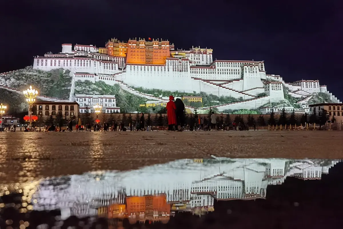
After dinner, we walked several kilometres through the city to the Potala Palace Square and admired the Potala's night view. Bathed in light, the palace looked like a celestial temple drifting in the air, glittering with splendour. The square was full of tourists, all capturing the iconic sight and sharing travel stories.
Day's drive: 600 km. Fuel: 365 yuan.
We had booked Potala Palace tickets a day earlier, so we could visit in the morning. The architectural and restoration history of the Potala is well known, but seeing it up close and inside, I was still awed by its grandeur and uniqueness. Built into a mountain, the vast palace is over 400 metres wide, more than 300 metres deep, and nine storeys high. Its external form is complex and imposing. The red, white and yellow colours are vivid yet harmonious, pleasing to the eye. From the walkway linking the main halls, we climbed winding stairs; with every turn, a different style appeared. The walkway balustrade was constructed with bricks interspersed with dried grass – the main walls likely had a similar structure. Later I learned this is baima grass, treated with solutions, lightening the wall and aiding ventilation. From the walkway, gazing out, all of Lhasa was visible, fresh and crisp. On the distant mountain meadow, the huge words 'Long Live the Motherland' were set into the slope.
Up to the palace entrance, inside we found hall after hall and rooms beyond counting; thangkas and murals everywhere; golden statues of Buddhas, arhats and bodhisattvas abounded. Gilded holy objects atop each hall gleamed in the sunlight. In the uppermost hall, the central display was a golden stupa presented by Emperor Qianlong to the Potala. The guide said it weighed more than three tonnes. After some time admiring, we followed the flow down through the palace, exited from the rear, and walked slowly around the complex. Many monks were making pilgrimages around the Potala, prostrating themselves every few steps and chanting sutras; many tourists offered small sums.
Leaving the Potala, we returned to the square to continue admiring the masterpiece from afar. Later, strolling the streets, we stumbled upon a small eatery with 'Cantonese Cuisine' written on it. We went straight in, where we heard the welcoming sounds of Cantonese and tasted the flavours of home!
In the afternoon, we visited the Jokhang Temple, a major Tibetan Buddhist temple built under the patronage of Songtsen Gampo in the Tang Dynasty. Locals consider the Jokhang as the heart of Chinese Tibetan Buddhist monasteries and the centre of the Buddhist world, making it deeply sacred. The temple is magnificently constructed; its main hall faces west and enshrines a statue of Shakyamuni. Around the main hall are smaller chapels to various Buddhas and bodhisattvas. Butter lamps burned everywhere, releasing a distinctive fragrance very different from the choking incense smoke in south-eastern coastal temples. We paid respects before the main Buddha, then visited a few side chapels. Afterwards we climbed to the second-storey terrace to view the temple's main structure, then left. Today we hired a guide, which helped us learn a lot about Tibetan Buddhism, the Jokhang, the Potala and other precious buildings, plus local legends – well worth it.
Outside the Jokhang extends Barkhor Street, lined with shops selling Tibetan crafts and specialties. We browsed a while before returning to the hotel.
Day's itinerary: city sightseeing, tickets and expenses about 1000 yuan.
Morning: We packed, walked to a nearby pedestrian overpass to catch the morning light on the Potala Palace, then reluctantly left Lhasa. We drove north on National Highway 109 for about four hours, reaching Damxung County, then turned into the Namtso scenic area. We bought tickets at the visitor centre, had a simple lunch, and headed deeper in. At one viewpoint, while we were taking in the scenery, a little girl bounced out of a herdsman's hut. Her plateau-flushed cheeks bore a cheerful smile, and her eyes sparkled as if they could talk – utterly adorable. We pressed some snacks on her while clicking the shutter. This little interlude added a cheerful note to our journey.
Continuing, we crossed the 5,200-metre Nagenla Pass and caught sight of Namtso, another of Tibet's three great holy lakes. It's enormous, said to be about the size of Shenzhen. From the parking lot, a walk of about a kilometre brought us to the shore. The water was incredibly clear. In the sunlight it was brilliantly transparent, framed by distant snowy peaks and blue sky – breathtaking. Tibetan herders brought white yaks to the lakeside for visitors to pose and photograph, singing Tibetan songs that brought the scene to life.
After visiting Namtso, it was still early, so we continued on. Since we weren't yet fully prepared for Mount Everest or the Ngari region, finishing Namtso meant the main highlights of our Tibet trip were complete. Leaving, there was a touch of sadness.
Our plan was to return to Sichuan via the northern Sichuan-Tibet Highway, so we left Damxung and carried on north along National Highway 109, mostly above 4,000 metres. Occasionally we glimpsed a train on the Qinghai-Tibet Railway, as if stepping into an old movie – everyone gasped. After over three hours, we arrived at Nagqu city at 4,650 metres and checked into a hotel. It was our first night at such elevation, and the room's oxygen supply wasn't great, so we had some headaches and breathing difficulty at night.
Day's drive: 350 km. Fuel: 470 yuan.
Sleep was poor owing to altitude sickness, and we longed for dawn. Nagqu city is the junction of National Highway 109 (the Qinghai-Tibet route) and National Highway 317 (the northern Sichuan-Tibet route). We took 317 eastward, driving through plateau terrain at four to five thousand metres, mostly alpine meadows dotted with Tibetan buildings. The stretch between Nagqu and Sog County was full of pothole-riddled road repairs, draining time and energy. Passing through Baqen and Dingqing counties, by the time we reached Riwoqê County it was getting dark, so we stopped for the night.
Day's drive: 530 km. Fuel: 440 yuan.
From Riwoqê, we continued east. Over one four-to-five-thousand-metre mountain after another, around countless hairpin bends, by around 4 p.m. we crossed the Jinsha River Bridge back into Sichuan – great to be back! After three more hours, we entered Garzê city by dusk.
Day's drive: 600 km.
Leaving Garzê, we headed towards Sêrtar and reached the Sêrtar Larung Gar Buddhist Academy around noon. At the gate, we learned it was not yet open – neither vehicles nor pedestrians were allowed in, which was disheartening. After walking around a bit, we met a local who said he could guide us on foot up the adjacent hill for a distant view of the academy. So we set off with this 'guide.' The path wasn't long, but climbing a small slope at over 4,000 metres is strenuous. Fortunately we'd been active on the plateau for several days and were somewhat adapted; apart from one member needing the guide's assistance, we managed. After about 40 minutes, we could overlook the academy's interior. A little further, we saw other visitors walking, so we followed onto the campus paths.
Along the way, we saw small red wooden huts – living quarters for teachers and students. Men and women, young and old, all in monastic robes, passed in and out. Following the lane to a bus stop, that was the campus centre, beside which a staircase led to the hilltop. Climbing a stretch, we saw the full panorama of the academy. Under the blue sky rose lush green mountains, and from the base to halfway up, countless red cabins of varying sizes were packed together – spectacular, a visual shock. Looking down on the bus stop square, people in dark red robes bustled about. The scene felt both novel and mysterious, as if there was a great distance between us and this image, yet we were clearly inside it – a strange sensation. Since the academy wasn't fully open, we didn't seek information or explore further, nor did we head up towards the sky burial site. After lingering a while, we left Sêrtar and continued our journey home, stopping in Barkam county for the night.
Day's drive: 350 km. Fuel: 340 yuan, other expenses 200 yuan.
Days 16 and 17:
From Barkam back to Shunde in Guangdong, we passed through Sichuan, Guizhou and Guangxi, with little lingering. Keeping a return rhythm, we arrived home on the evening of August 1st, ending an arduous, thrilling yet immensely enjoyable trip.
Two-day drive: 2,050 km. Fuel: 1,000 yuan, tolls: 1,100 yuan.
These are my diary entries from the Sichuan-Tibet journey. Overall, on the Sichuan-Tibet route, the scenery is truly on the road itself – every step and every angle is a beautiful picture. Designated scenic spots let you get closer to the highlights, so they're well worth visiting. The driving experience and daily life are also part of the trip's value. National Highways 317 and 318 are rugged: tight curves, narrow roads, often sharp bends every few dozen to hundred metres, or threading between cliffs, riversides and towering mountains. Overtaking, especially a huge truck, often required waiting for several opportunities. Fortunately, many truck drivers were very considerate; when they saw a chance between bends, they would stick a hand out to signal us to pass, enabling overtaking on curves.
Moreover, on these oxygen-scarce high-altitude roads, we frequently encountered brave motorcyclists, cyclists, hikers carrying heavy packs, even prostrating pilgrims advancing step by step – their sheer determination moved us deeply! They formed a striking contrast with the highland environment and road conditions, becoming a unique scenic line themselves, embellishing nature.
From the Chengdu area to Lhasa, under normal conditions it takes about five days. If unexpected road washouts or repairs occur, you must wait in place. So it's important to plan each night's stopping point carefully, as only county towns have relatively decent food and accommodation. Also, stay in lower-altitude counties to ensure quality rest – two county towns are often two to three hours apart.
Even though I'd been to other high-altitude places before, we still experienced various degrees of altitude sickness on this trip. This shows that altitude reaction varies with individual physical condition, mental preparation, weather and other factors. From this experience, I've learned: First-timers on the plateau should neither fear nor underestimate it. Before reaching 3,500 metres, it's best not to eat too heavily to avoid burdening the digestive system. Above 3,500 metres, avoid strenuous actions (like jumping or running) and don't expose yourself to cold wind. If you feel slightly unwell, take small, intermittent oxygen to slow the rate of oxygen deprivation to the organs. If headache, vomiting etc. occur, take appropriate medication promptly to relieve symptoms. When your condition stabilises a bit, increase the interval between oxygen uses until you stop.
After entering the plateau, in a calm state, the reaction tends to be most intense in the first one to two hours. But with proper management, it starts easing after six to eight hours. Avoid continuous oxygen, or adaptation will take much longer.
The Sichuan-Tibet journey is a tour of scenery and life experience, a driving challenge and delight. Though some time has passed since it ended, the joy and hardship are still intensely memorable. Looking forward to the next even more wonderful trip!
All text and images above are original. Please do not use without permission, or you may face legal liability!!!
Shanqingshuixiu and party
Autumn 2020


