The Ultimate Drive: Sichuan-Tibet Highway 318
Two cars with four people set out from Chengdu on Children's Day this year.
Met up at the Pujiang service area and hit the road.
Passed through Erlang Mountain Tunnel, crossed Dadu River Bridge, and arrived in Kangding.
Luding Dadu River Bridge: Known as the 'First Bridge of Sichuan-Tibet' (formerly Xingkang Extra-large Bridge in Luding).
Kangding: At an elevation below 3,000m (around 2,560m), it's the ideal first stop when entering Tibet.
Kangding: A world-renowned historical and cultural city. Paoma Mountain has earned fame far and wide. The classic 'Kangding Love Song' has enchanted people around the globe for ages.
Crossed the first high mountain on the Sichuan-Tibet line: Zheduo Mountain.
Zheduo Mountain: The first major pass on the Sichuan-Tibet Highway, hence known as 'The First Gateway to Kham'. Elevation 4,298m.
Cattle crossing the road.
Stopping here and there, we found a spot in Xinduqiao for lunch.
After Xinduqiao, we took a break in Yajiang (elevation 2,640m). Beyond this point, we'd be entering high-altitude terrain.
Yajiang: In Tibetan, it's called 'Yaquka', meaning 'river mouth'. It was once an important ferry crossing on the Yalong River.
Evening sky over Yajiang.
Today's first scenic spot: the '18 Bends of the Sky Road' on National Highway 318.
After crossing the 18 Bends, there are three viewing platforms: 1. 18 Bends Viewing Platform, 2. Xiongzongka Viewing Platform, 3. Kazila Mountain Viewing Platform.
We stopped at Xiongzongka (elevation 4,281m).
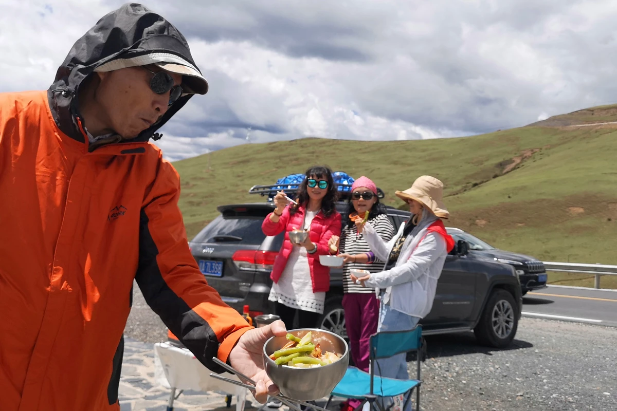
Our first roadside meal of the trip drew the attention of passing cyclists.
Feeling a bit dizzy, we arrived in Litang without even crossing Kazila Mountain. Turns out, after the Jianziwan Tunnel opened, you no longer need to go over Kazila. I wasn't in great shape this time—actually got altitude sickness in Litang. Did I overestimate myself? Thank goodness the room had oxygen.
Knights of the Sichuan-Tibet Highway.
Entered the county town through Litang's East Gate.
After a good night's rest, I felt much better. We first visited Renkang Ancient Street, then continued on. Today's plan was to stay in Batang.
Renkang Ancient Street: Located in Chema Village, the first village in Litang County. Originally just 18 households, its old name meant 'black tent'.
The Renkang and Mangkang residences are built with rammed earth walls. There are two types: 'rammed walls' (da qiang) made from fine clay without any stones, and 'poured walls' (dao qiang) where the earth contains many stones. The Renkang and Mangkang homes use the latter style, which lasts longer than rammed walls—these have stood for over 400 years.
The poem by Tsangyang Gyatso: 'White crane, lend me your wings. I will not fly far; just to Litang for a turn and back.' It hints that his reincarnated soul would be born in Litang.
Left a message at the Renkang Travel Memory Museum before heading out.
Crossed Haizi Mountain as a light rain began to fall.
Sister Lakes in the rain.
The sky was overcast, with snow-capped peaks barely visible.
In a pitch-dark tunnel, we drove slowly to light the way for the cyclists ahead.
Batang's pedestrian street.
The highland barley is almost ripe.
Leaving Batang town, the road at Zhubalong was under construction. Since traffic control starts after 8 a.m., we set out from the hotel at 6:15 to get through in time.
Today we planned to stay in Markham, but since we arrived early, we decided to push on to Zuogong for the night.
At 8:30, we reached the Chamdo police checkpoint and officially entered Tibet.
Our first viewing platform after entering Tibet: Lawu Mountain (elevation 4,376m).
Then Jueba Mountain (elevation 3,911m).
Dongda Mountain towers at 5,130m. Stepping out of the car, we felt like we were floating.
First stop in Tibet: Zuogong.
First stretch of the journey in Tibet: from Zuogong to Baxoi.
Yela Mountain Pass (elevation 4,658m): The pass is relatively gentle. From the top, you can clearly take in the scenery on both sides. Due to geology, the summit rocks are heavily weathered, and the bare rock faces in the distance look like an ancient, weathered city gate.
The 72 Hairpin Bends of the Nu River.
Roadside lunch at the 72 Bends viewing platform.
Nu River Bridge: With the longest single-span in China and second in Asia, the bridge stretches 678m long and 15.8m wide. It serves as the only vital link connecting the eastern and western parts of Liuku town.
Amid wind and rain, we set out from Baxoi.
Encountered snow on Anjula Mountain (elevation 4,475m).
Checked into Ranwu Town, a small settlement on the Sichuan-Tibet Highway. Small as it is, Ranwu boasts soul-stirring mountains, lakes, and a modest pasture. A white Ruyi stupa stands in harmony with the distant snowy peaks, showcasing the deep Tibetan cultural flavor.
Another rainy day. Rain or shine, we still had to check in at Laigu Glacier.
We retraced our route, passed through Ranwu Town again, and went to have lunch by Ranwu Lake.
After the rain, misty mountains and grey waters defined Ranwu Lake.
It drizzled all the way.
Hikers pressing on in the rain.
We quickly passed a landslide zone.
Arrived in Bome, the ancient homeland of Tibetan kings (county seat: Zhamu Town, elevation 2,720m) amid wind and rain.
With heavy recent rain and road construction to Mêdog (alternating one-way traffic), we skipped Mêdog and headed straight for Lulang Town.
Here marks the 4,000km point of National Highway 318.
Tongmai Bridge: The key project on the infamous Tongmai natural barrier section of the southern Sichuan-Tibet Highway (G318). At this spot, three bridges from different eras span the river. The main one in use is the single-pylon cable-stayed Tongmai Bridge; the two older bridges are now closed to motor vehicles.
Lulang Town: In Tibetan, Lulang means 'Dragon King Valley', a place so beautiful it 'makes you forget home'. It is a town under Nyingchi County in the Tibet Autonomous Region.
Missing out on stone-pot chicken in Lulang would be a regret. The pot is hollowed from a single block of stone, the chicken is a free-range local Tibetan bird, and it's slow-cooked with snowmelt stream water, plus ginseng, Tibetan fritillary bulbs, lily, goji berries, and other herbs. An absolute delicacy.
Stayed at the Nyingchi Hengda Hotel, which came with two complimentary stone-pot chicken meals.
Morning: took a stroll around Lulang Town.
Back to the room for a short rest, then ready to depart.
Departed: driving toward Nyingchi.
Sejila Mountain viewing platform: meant for watching Namcha Barwa Peak, but weather wasn't cooperative today—the peak remained hidden.
Arrived in Nyingchi, known in ancient times as Kongpo and hailed as the 'Switzerland of Tibet'. It's home to the world's deepest canyon—the Yarlung Tsangpo Grand Canyon—but we only passed by this time.
The Nyang River flows through Nyingchi from west to east, joining the Yarlung Tsangpo River near Zemen in Nyingchi County.
Legend says the Nyang River is the sorrowful tears of the sacred mountain. With well-preserved forests along its banks and clear, low-silt water, it's the 'mother river' of the Kongpo people.
From Nyingchi to Lhasa is all expressway. We visited Basum Lake, then stopped for a rest in Gongbo'gyamda.
Basum Lake, also known as Tso Go, means 'green water' in Tibetan. With an elevation over 3,700m and an area of more than 6,000 mu (about 400 hectares), it lies in a high gorge on the upper Ba River, over 50km from Gongbo'gyamda County. It's a famous sacred lake and holy site in the Red Sect of Tibetan Buddhism.
A morning in Gongbo'gyamda.
A few riders born in the 1960s rented a car to Lhasa.
The final leg to Lhasa.
The last pass to cross: Mira Pass, elevation 5,013m.
Thus we arrived in Lhasa, completing the first leg of the journey (2,130km over 12 days). To recap: Chengdu – Kangding (Zheduo Mountain, Xinduqiao) – Yajiang (18 Bends of the Sky Road, Xiongzongka, Nimagong Sacred Mountain) – Litang (Renkang Ancient Street) – Batang (Sister Lakes, Haizi Mountain) – Zuogong (Lawu Mountain, Jueba Mountain, Dongda Mountain) – Baxoi (72 Bends of the Nu River, Nu River Bridge) – Ranwu Town (Anjula Mountain) – Bome (Laigu Glacier, Ranwu Lake) – Lulang Town – Nyingchi (Lulang Forest, Basum Lake) – Gongbo'gyamda – Lhasa (Mira Mountain)


