Hidden Gems in Sichuan, Yunnan, Qinghai, and Tibet: How the Hengduan Mountains Reveal Shambhala (I) — Yunnan, the Land of Colorful Clouds
Hidden Gems in Sichuan, Yunnan, Qinghai, and Tibet: How the Hengduan Mountains Reveal Shambhala (I) — Yunnan, the Land of Colorful Clouds
1. Wonders Along the Geographic Boundaries. Wang Anshi once observed, 'The most extraordinary, majestic, and unusual sights are often found in perilous and remote places.' This rings true. China's famous mountains and rivers, World Heritage sites, 5A scenic areas, and diverse ethnic groups are highly concentrated along the boundaries of its three topographical steps. The first step, above 4,000 meters, is dominated by plateaus — bounded by the Kunlun, Qilian, and Hengduan mountains. The second step, 1,000–2,000 meters, features plateaus and basins — bounded by the Greater Khingan, Taihang, Wu, and Xuefeng mountains. The third step, below 500 meters, consists mainly of plains and hills.
2. The Hengduan Mountains. During the Qing Dynasty, an official named Huang Maocai was sent by Sichuan Governor Ding Baozhen to Tibet. Gazing westward at the rolling mountain ranges, he couldn't help but exclaim, 'These truly are mountains that cut across (hengduan)!' Perhaps this is how the name Hengduan Mountains originated. 65 million years ago, the Indian Plate collided violently with the Eurasian Plate from south to north, drastically uplifting the Qinghai-Tibet Plateau and releasing pressure to the east and west. At the eastern end, it met stubborn resistance from the Yangtze Plate. Where they clashed, the earth was squeezed and compressed, forming large-scale folds and faults — and thus the Hengduan Mountains were born. Mountain ranges typically extend in certain directions, known as their strike. Among China's many mountains, east-west and northeast-southwest strikes are most common, each with three groups. The east-west-trending ranges include the Tianshan-Yin mountains, Kunlun-Qinling, and Nanling. The northeast-southwest-trending ones include Greater Khingan-Taihang-Wu-Xuefeng, Changbai-Wuyi, and the Taiwan mountains. Besides these, China also has north-south-trending mountains, the most representative being the Hengduan Mountains in the southwest. The Hengduan region comprises seven north-south mountain ranges (west to east): Boshula Ling - Gaoligong Mountain, Taniantaweng Mountain - Nu Mountain, Mangkang Mountain - Yunling, Shaluli Mountain, Daxue Mountain, Qionglai Mountain, and Min Mountain — known as the 'Seven Hengduan Ranges.' It also includes six north-south parallel rivers (west to east): Nujiang, Lancang, Jinsha, Yalong, Dadu, and Min rivers — the 'Six Hengduan Rivers.' Some scholars define the Hengduan region as bounded by Min Mountain in the east, Boshula Ling - Gaoligong Mountain in the west, the Baoshan-Dali-Lijiang-Xichang line in the south, and the Shiqu-Ruoergai line in the north. The Hengduan region is one of China's richest areas for hidden paradises. World Heritage sites here include: Mount Emei (an extension of Qionglai Mountain), Dujiangyan at the Min River's outlet, Mount Qingcheng (a branch of Qionglai), Huanglong, Jiuzhaigou, the Giant Panda Sanctuaries, the Old Town of Lijiang, and the Three Parallel Rivers — seven in total. It boasts four of China's top ten most beautiful mountains: Meili Snow Mountain, the Three Sacred Mountains, Minya Konka, and Mount Emei. Four of the top ten gorges: Tiger Leaping Gorge on the Jinsha, Meili Grand Canyon on the Lancang, Nujiang Grand Canyon, and Jin Kou Grand Canyon on the Dadu. Two of the most beautiful ancient towns: Danba Tibetan Village and Dayan Old Town. One of the top ten waterfalls: Nuorilang Waterfall. One of the most beautiful glaciers: Hailuogou Glacier. One of the most beautiful forests: Baima Snow Mountain alpine rhododendron forest. One of the most beautiful wetlands: Ruoergai. And one of the most beautiful grasslands: the West Sichuan alpine grassland. (All selections referenced from Chinese National Geographic's 'Beauty of China')
In the summer of 2012, I took a Sichuan Airlines flight from Chengdu, about 40 minutes, arriving at Lijiang Airport. Then a tourist bus to Lijiang city. The moon was full, the sky clear and brisk, with a gentle breeze. I walked into the Old Town of Lijiang. Though late at night, lights blazed and music drifted endlessly. My companion, Brother Liu, couldn't help remarking, 'I thought we came too late, but it's still early.' Still a bit weary from the journey, I retired to an old courtyard guesthouse.
The next day I went to Lashihai on the outskirts of Lijiang. Perhaps it was the dry season, for there was no alpine lake to be seen, only a wetland — nothing worth noting.
From Lashihai I returned to Shuhe Ancient Town. In the Naxi language, it is called 'Shaowu,' derived from the shape of Jubaoshan (Treasure Gathering Mountain) behind the village — resembling a towering peak. The village took the mountain's name, which evolved to mean 'village beneath the high peak.' It is a well-preserved key market town on the Ancient Tea Horse Road. The Ancient Tea Horse Road was a network of commercial trade routes in southwest China, using horse caravans as the main transport, serving as a corridor for economic and cultural exchanges among ethnic groups in the southwest. It had three main routes: Shaanxi-Gansu, Shaanxi-Kang-Tibet, and Yunnan-Tibet. The Yunnan-Tibet Tea Horse Road likely took shape in the late 6th century. It started from the main tea-producing areas of Simao and Pu'er in southern Yunnan, passed through today's Dali Bai Autonomous Prefecture, Lijiang, and Shangri-La, then entered Tibet and reached Lhasa.
Shuhe Ancient Town nestles with its head on Jubaoshan and shoulders by Lashihai, close to Dayan Old Town. A gentle stream flows through the town. Along the banks are Naxi-style houses, taverns, inns, and shops, with 'curving corridors and high, upturned eaves, each embracing the terrain in intricate interplay.' The flagstone streets, trodden by caravans and travelers over the years, are burnished with a patina of age, gleaming faintly in the dark. The shops here are small, packed with an array of goods that catch the eye. There is no blaring music, no shouting vendors, no hordes of tour groups. Only occasional whinnies and jingling copper bells from horses on the square. Life here is slow, unhurried, content with just a sliver of sunlight — and it feels just fine. When the last ray of sun drops behind the mountain, Shuhe gets ready to sleep...
When the last ray of sun disappears, Dayan Old Town rolls over and awakens...
Dayan Old Town is what we commonly refer to as the Old Town of Lijiang. Today's Lijiang city comprises the old town and new town; the old town is Dayan.
Meltwater from Jade Dragon Snow Mountain nourishes the Lijiang basin, making it a fertile area and a goods distribution hub. The Naxi people living here have always regarded Jade Dragon Snow Mountain as a sacred mountain. In the 15th year of the Hongwu reign (1382), the Tong'an prefect A'jia A'de submitted to the Ming Dynasty, and the Lijiang Military-Civilian Prefecture was established. A'jia A'de was given the surname Mu by Zhu Yuanzhang and made hereditary prefect, so Lijiang long remained under the control of the Mu chieftains. In the following year (1383), Mu De built the 'Lijiang Military-Civilian Prefecture Office' at the foot of Shizi Hill. During the Qing Dynasty's 'replacement of native chieftains with imperially appointed officials,' the Mu chieftaincy was abolished, and the central government dispatched circulating officials to administer the area. The 'Mu Mansion' seen today is a modern replica and holds little historical or cultural value.
As night falls, the lights of Dayan Old Town flicker on one by one, and people from all directions gradually gather. The town slowly stirs, becomes crowded, and reaches a crescendo around 8 or 9 p.m. When the crowds on the streets thin, the taverns remain awake. People chat softly, and a singer croons country tunes. As the drinks flow, under the colorful lights, a dreamy haze takes over. The music quickens, turning rockier. At some point, the folk singer has left the stage, replaced by a hoarse-voiced man pouring out life's bitterness in a frenzied release.... A night of unbridled indulgence — that is the allure of Lijiang.
From Lijiang to Shangri-La City, the road winds through mountains. The bus ride takes about 2 hours to the First Bend of the Yangtze River.
The First Bend of the Yangtze is located between Shigu Town in Lijiang and Shasunbi Village in southern Shangri-La County, at an elevation of about 1,850 meters. The mighty Yangtze originates from the Nyainqêntanglha Mountains in Qinghai, with the main source being the Tuotuo River, the northern source the Chumar River, and the southern source the Dangqu River in Xingxiuhai. The Jinsha River is the upper course of the Yangtze; it becomes the Yangtze after merging with the Min River at Yibin. During the Song Dynasty, alluvial gold was abundant along the river — 'gold comes from the Li River' — and so it was renamed Jinsha (Golden Sand) River because of the many gold panners. The Ming geographer Xu Xiake, after field investigations, asserted that 'to seek the source of the Yangtze, one must begin with the Jinsha,' correcting a long-standing misconception. Folklore tells of three sisters — Nujiang, Lancang, and Jinsha — who set out traveling together. They quarreled along the way; the elder two stubbornly went south, but the youngest, Jinsha, was determined to seek light and love in the east where the sun rises. Upon reaching Shigu, she bade her sisters farewell and resolutely turned eastward. That turning point is the First Bend of the Yangtze. On the map, the Jinsha River turns at Shigu, ending the parallel flow of the three rivers. It heads northeast through Tiger Leaping Gorge, then turns south again, eventually forming the 'Mother River' Yangtze. Otherwise, like the Lancang and Nujiang, it would have flowed out of the country into Southeast Asia, 'married off' to foreign lands.
Another half hour to Tiger Leaping Gorge.
Tiger Leaping Gorge is located in Tiger Leaping Gorge Town, Shangri-La City, divided into Upper, Middle, and Lower Tiger Leaping sections, winding for 25 kilometers. Jade Dragon Snow Mountain rises to the east, Haba Snow Mountain to the west, with a vertical drop of over 3,900 meters — making it one of the world's deepest gorges. I only visited Upper Tiger Leaping. Descending from the tourist center parking lot to the Jinsha River, the previously broad river narrows to about 30 meters here. The unruly Jinsha River, chafing at this chokehold, suddenly erupts in fury, churning yellow waves, roaring skyward. A reef stands midstream like a bone in the throat; the raging current pounds it, sending spray soaring several meters high, water droplets flying and mist rising — a heart-stopping spectacle. It's said that someone once saw a tiger leap from the opposite bank onto this mid-river rock, then spring again to the near bank, hence the name 'Tiger Leaping Gorge.' A late resident of my city (Leshan), Yao Maoshu, historically known as 'the first to raft the entire Yangtze,' navigated some 1,270 kilometers of the Jinsha River but perished in Tiger Leaping Gorge on July 24, 1985, never fulfilling his dream. It is said he waited days at Shigu Town, then grew impatient and risked the attempt, leading to the tragedy. Seeing the gorge today, I couldn't help but sigh at how helpless humans are before nature. On the opposite bank, a narrow path twists along the terrain — the old Tea Horse Road. Looking up, the mountain is steep, jagged boulders jutting into the clouds. Amid the mist and clouds, a conical snowy peak looms half-hidden, mysteriously appearing and disappearing — that is Haba Snow Mountain. As the saying goes, 'Seen from the side, a mountain range; seen from the front, a peak, different far, near, high, and low,' Haba Snow Mountain is precipitous on the Tiger Leaping Gorge side but much gentler on the other, suitable for novice mountaineers to practice on. Driving in the gorge, with towering mountains and narrow valleys, occasional rocks tumble down and pile by the road — a hair-raising experience.
In the early 20th century, American explorer Joseph Rock penetrated deep into the Hengduan Mountains of southwest China. Dazzled by the snow-capped peaks, forests, grasslands, lakes, rivers, pastures, and local customs, he published articles and photos in National Geographic, calling this a Buddhist pure land — 'Shambhala.' In 1933, James Hilton, inspired by Rock's descriptions, wrote Lost Horizon, which first depicted a place of eternal peace and tranquility hidden among eastern mountains — 'Shangri-La.' During World War II, people ravaged by war longed for such a peaceful haven, and 'Shangri-La' captured the world's imagination. Driven by rapid tourism development, the Diqing Tibetan Autonomous Prefecture in Yunnan announced they had found Hilton's 'Shangri-La,' and in 2001, it renamed itself Shangri-La City, gaining instant fame.
Songzanlin Monastery, not far outside the city, is the largest Tibetan Buddhist monastic complex in Yunnan and a Gelug (Yellow Hat) center for the Sichuan-Yunnan region. Built into the hillside, it resembles a fortress and represents the zenith of Tibetan architectural art, earning it the name 'Tibetan Art Museum.'
Pudacuo National Park is Shangri-La's most representative attraction. We set out by tourist bus at 6 a.m., in the chill darkness, heading for the Pudacuo visitor center. Along the way we stopped briefly at a clothing rental shop, then continued as the sky slowly brightened. By the roadside, grasslands dotted with pretty Tibetan houses emerged; livestock were still in their pens, and a thin mist clung to the green pastures. From the visitor center, we took shuttle buses with convenient stops. The first stop was Shudu Lake. At 3,705 meters elevation and covering 15 square kilometers, the lake is broad, encircled by high mountains, its water deep blue and pure. A wooden boardwalk along the shore makes for comfortable strolling. Walking by the lake, the breeze sometimes greets you, a squirrel darts past, a giant mushroom suddenly appears, you pass through forests, skirt meadows, and chance upon rhododendrons... a feast for the eyes and endless delightful surprises. The towering, verdant alpine firs and the wildflower-strewn meadows contrast beautifully with the cool, expansive Shudu Lake. Birds chirp melodiously, and white and brown horses graze peacefully on the lakeside grasslands — nature has arranged such a perfect combination. At 3,705 meters, walking around the lake, I felt no altitude sickness, no shortness of breath; instead, I felt lighthearted, as if brimming with oxygen. Was it really 3,705 meters? I still wonder today. The second stop is a blur — we missed Bita Lake. Around noon we returned to the visitor center, passing alpine meadow scenery all the way. For a first-timer like me, it was a joy so overwhelming I didn't want to leave — but, alas, we had to.
In the 8th century, the ancestors of the Bai people established the Nanzhao Kingdom in the Erhai Lake region. Nanzhao maintained friendly ties with the Tang Dynasty, and with Tang support, unified six 'zhao' (tribal states). After Nanzhao fell, three short-lived dynasties rose in the Erhai area. Duan Siping, founding king of the Dali Kingdom, implemented new policies, reformed governance, and promoted rule by rites. He named the kingdom 'Dali,' meaning 'greatly harmonizing all relationships' to facilitate development. The Dali Kingdom lasted for 22 generations of rulers over 316 years. Dali long served as the political, economic, and cultural center of Yunnan. It was not until the Yuan Dynasty established the provincial capital in Kunming that Dali gradually lost its preeminence.
Dali — the greater the expectation, the greater the disappointment. The marvels of Dali are encapsulated in a local saying: 'Upper Pass flowers, Lower Pass wind, Cangshan snow, Erhai moon.' Upper Pass had no flowers. Butterfly Spring is at Upper Pass; I thought I'd see butterfly-like flowers there, but there were none. Perhaps like 'wife cakes' that have no wife inside. Lower Pass seems to sit in a wind tunnel. When we arrived at dusk, the wind blew nonstop, with no sign of ceasing. The Torch Festival was approaching, and villagers selling wooden torches thronged the streets, lending a festive air. Early August, in the dog days of summer, the evenings in Dali were pleasantly cool, made even more comfortable with the Lower Pass wind. Unfortunately, Cangshan definitely had no snow — just dark green mountains encircling Erhai, the two complementing each other; with mountains and a lake, the place had charm. Erhai, though listed last among the 'Four Scenes of Dali,' is indisputably the star. The lake covers about 246 square kilometers, holding some 2.95 billion cubic meters of water. Elongated in shape, it stretches 40 kilometers from Eryuan County in the north to Xiaguan in the south, at an elevation of 1,972 meters. It is the second-largest lake in Yunnan after Dianchi and the seventh-largest freshwater lake in China. We took a boat from Upper Pass to Xiaguan to tour Erhai. Viewing the lake from the water, its misty vastness really did feel like a sea. With a clear blue sky, picturesque Cangshan, and jade-like Erhai, the crisp weather lifted our spirits. A friend said that a few years ago, Erhai's water was crystal-clear, with aquatic plants visible; now the lake appeared dark and murky, faintly fetid, seemingly badly polluted — a real letdown. Dali's rapid tourism development has brought wealth but also severe environmental degradation. Erhai is no longer a great sight. I visited Erhai in early August 2012, and I record this here to see if restoration efforts have worked.
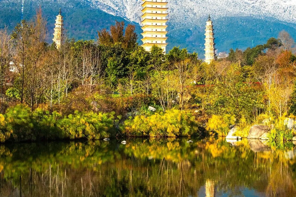
Chongsheng Temple, facing Erhai to the east and backed by Cangshan to the west, is the 'Tianlong Temple' in Jin Yong's martial arts novel Demi-Gods and Semi-Devils. It was the royal temple of the Dali Kingdom, where kings would retire to monastic life, and it holds great historical significance in Dali. Although the temple has ancient origins, the old buildings are almost completely destroyed, with only the three pagodas remaining. The three pagodas of Chongsheng Temple were first built during the Kaiyuan reign of the Tang Dynasty. The main pagoda, Qianxun Pagoda, stands 69.13 meters tall with a square base of 9.9 meters and 16 tiers, a typical multi-eaved hollow square brick pagoda of the Dali region. The two smaller pagodas to the north and south are each 42.17 meters tall with ten tiers, octagonal multi-eaved hollow brick pagodas. The three pagodas, forming a harmonious whole, appear as one body with two wings, echoing each other — a masterpiece of superb craftsmanship. Indeed, 'The three pagodas mark this wondrous site, hidden from mortal hands by divine work.'
From Dali I returned to Lijiang, then flew back to Chengdu on Sichuan Airlines. After a week of travel, I had much to reflect on, hence this record.


