Shandong Travel: Exploring the Southern Route of Mount Lao in Qingdao (Photos)
Most visitors to Qingdao make a point of seeing Mount Lao, yet the mountain is so vast—that’s the striking impression I got on my third trip along the southern route. I first visited Qingdao in the late 1970s. My memory is hazy, but thinking back, I realize that on that occasion I went to Beijiushui, which is the northern scenic area of Mount Lao.
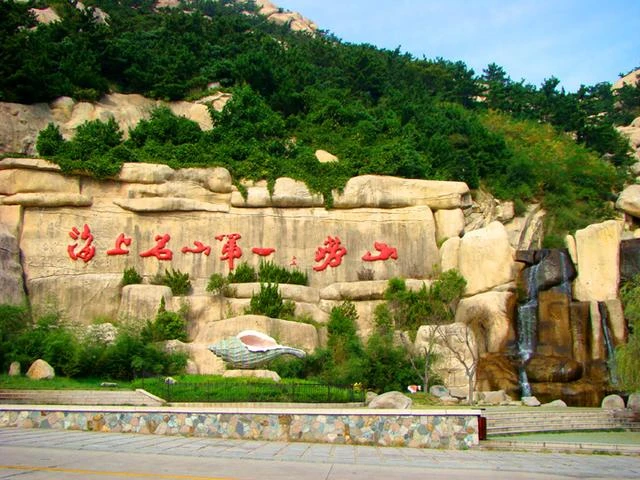
"The Foremost Famous Mountain on the Sea – Mount Lao" (Photo by Feng Ganyong)
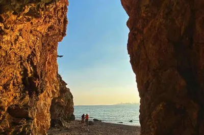
In 2004, on my second trip to Mount Lao, I followed road signs from Qingdao and somehow ended up at the southern scenic area. It was pouring rain, and I had a photo taken in the rain in front of the rock inscription "The Foremost Famous Mountain on the Sea – Mount Lao" before heading back.
Photo at Mount Lao (Photo by Sun Minghe)
On September 18, 2008, guided by my Qingdao friend Li Xiaoping, I drove to Mount Lao again. After less than an hour, to my surprise, I found myself back at the same spot where I’d taken the photo in the rain four years earlier—the rock inscribed "The Foremost Famous Mountain on the Sea – Mount Lao" with the mountain behind and the sea before. The difference this time was that we finally had a brilliantly clear, sunny day.
Layers of Forest in Vibrant Color (Photo by Feng Ganyong)
According to records, Mount Lao is located on the Yellow Sea coast in the southern part of the Shandong Peninsula, covering an area of 446 square kilometers. It faces the sea to the southeast and south, with a coastline winding around the mountain for 87.3 kilometers. Due to the intrusion of granite during the late Yanshan Movement, the mountain extends into the sea, creating a jagged coastline with numerous bays, capes, and peninsulas, as well as many offshore islands.
Gazing into the Boundless Sea (Photo by Feng Ganyong)
I entered the Bashui River entrance of Mount Lao and began a hike of over three hours. The mountain mostly consists of irregular, rounded boulders linked together. This is because Mount Lao’s body was already an anticlinorium during the Sinian Lüliang Movement, and the massive granite block began to form during the Cretaceous period. In the late Yanshan Movement, between about 130 million and 68 million years ago, white-hot magma surged up from deep in the earth’s crust and cooled several kilometers below the surface.
Pantao Peak of Mount Lao (Photo by Feng Ganyong)
The rock here comes in flesh-pink and white, with granular mineral crystals, and is geologically named "Laoshan Granite." At its birth, it was not exposed at the surface. Since the Cenozoic Era, uplift raised the land, and the overlying rock was gradually worn away by eons of wind, frost, rain, snow, and running water, finally revealing the granite. Beginning about two million years ago, in the mid-Cenozoic, it gradually took on its present shape. The Mount Lao we see today is a beautiful landscape carved by nature during the late Quaternary, shaped by tens of thousands of years of change.
A Hiking Trail on Mount Lao (Photo by Feng Ganyong)
The stone path wound gently upward—steep slopes were rare. Thanks to the excellent vegetation, most of the trail was shaded by lush trees, which eased the toil of hiking in the summer heat and blazing sun. Climbing from Bashui River past the ancient Ladder Stone site, I came upon a body of water midway up. A mountain without water lacks scenery. Here, a dam held back a broad expanse that mirrored the mountains, creating a tiny scene of lake and hills.
Longtan Waterfall Reservoir (Photo by Feng Ganyong)
It turned out to be the Longtan Waterfall Reservoir, part of the Bashui River system. Bashui River originates from behind Shangqing Palace, at Tianmenhou, Dongxiqi, and the east hill of Shangqing Palace. These three southern branches converge and tumble down at Longtan Waterfall, then flow south, passing east of Bashui River Village before emptying into the Yellow Sea. It runs north to south for 4.5 kilometers, with a catchment area of 8.6 square kilometers. Bashui River is a seasonal stream with sweet, cool water. Its name, meaning "Eight-Water River," comes from the eight brooks that join it.
Peace Locks on the Bridge (Photo by Feng Ganyong)
Further up, I reached Longtan Waterfall. A bridge spanned the gorge, its stone railings bedecked with peace locks tied with red cloth strips. Standing on the bridge, I had a panoramic view of the waterfall. Because of the season, the flow was modest and didn’t form a spectacular cascade, but the trickling streams sparkling in the sunlight were still a charming sight on Mount Lao.
Streams Babbling at Longtan Waterfall (Photo by Feng Ganyong)
Longtan Waterfall, also called "Yulong Waterfall" (Jade Dragon Waterfall), is fed by eight streams from the southern foothills, which merge into Bashui River. The water rushes down and plunges over a sheer cliff about 30 meters high, creating the falls. Because of the height and force, the water shoots through the air like a white dragon soaring from the clouds before crashing into the pool below. The roar echoes like a dragon’s cry, a majestic spectacle. The waterfall is named "Longtan" (Dragon Pool), and the pool it falls into is called "Yulong Tan" (Jade Dragon Pool).
Photo at Longtan Waterfall (Photo by Li Xiaoping)
Standing by the pool, I watched the plunging water—because of the great height and the gusty winds in the valley, the cascade was torn into a fine mist that drifted like rain and enveloped the gorge. The spray felt like being in a drizzle. This scene is listed among the "Twelve Famous Scenes of Mount Lao" and is called "Dragon Pool Sprays Rain."
Statue of Martyr Shi Jian (Photo by Feng Ganyong)
Below Longtan Waterfall, on one side, stands a rocky statue of a naval soldier, Martyr Shi Jian. In life, he was a cadet at the First Naval Aviation Technical School in Qingdao. On May 4, 1985, when flash floods struck, he, along with Ge Maojin and three other comrades, as well as young students who were present, bravely rescued stranded tourists. More than 200 tourists were saved, but Shi Jian was swallowed by the merciless flood. With his young life, he composed a heroic song of the military’s devotion to the people in this new era, right below Longtan Waterfall.
Climbers Gazing into the Distance (Photo by Feng Ganyong)
In 1985, renowned Chinese poet He Jingzhi visited Longtan Waterfall and, after hearing the brave deeds of Shi Jian and the others, composed a poem "Ode to the Mount Lao Heroic Group": "Looking west to Mount Hua, I sing of heroic groups; looking east at Mount Lao, another peak stands. The vitality of China can be relied upon after all; thinking of the torrents, hot tears flow." This poem is now engraved beside Shi Jian’s statue, making it a unique sight on Mount Lao’s southern route.
Entrance of Shangqing Palace (Photo by Feng Ganyong)
Continuing upward, I reached Shangqing Palace and Mingxia Cave, two ancient sites hidden deep in the forested mountains. Both have largely retained their original scale. Inside Shangqing Palace are a thousand-year-old ginkgo, 500-year-old boxwood, 200-year-old sweet osmanthus and crape myrtle, and 100-year-old lilac and azalea. From Mingxia Cave, climbing to the Heavenly Vault peak, I looked out to where mountain and sea merge. The "Southern Heavenly Gate" stood majestically, and as the sun rose in the east, the vast sea shimmered with blue waves.
Bagua Diagram Stone (Photo by Feng Ganyong)
The southern route of Mount Lao is primarily notable for its Taoist sites and natural scenery. Mount Lao is especially famous for its Taoist priests, and Shangqing Palace served as a Taoist center. Commonly called "Upper Palace," it was founded in the early Song Dynasty. It was originally built by Emperor Taizu (Zhao Kuangyin) as a ritual site for the Huagai Zhenren Liu Ruozhuo. By the end of the Song Dynasty, it had fallen into disuse. In the first year of the Dade era of the Yuan Dynasty, Master Li Zhiming, titled Tongxuan Hongjiao Donghui, oversaw its restoration. On a rock opposite the entrance of Shangqing Palace, a Bagua (Eight Trigrams) diagram is carved.
"Xiazhu Bantian" Rock Inscription (Photo by Feng Ganyong)
A walk of over half an hour from Shangqing Palace leads to Mingxia Cave, which is formed by huge piled boulders. Entering the cave, I first saw four characters "霞朱半天" on the stone wall—some say it should be read as "天半朱霞," meaning dawn glow reddens half the sky. Looking up from here, you can see only a sliver of sky. When the sun rises in the east, multicolored clouds bathe the peaks in red, creating a breathtakingly beautiful scene. This is listed among the "Twelve Famous Scenes of Mount Lao" as "Mingxia Scattered Splendor." The inscription "霞朱半天" was written by Shao Yuanchong, a veteran Kuomintang statesman.
Jade Emperor Hall at Mingxia Cave (Photo by Feng Ganyong)
To the left of the cave is the founding temple of the Taoist Quanzhen Jinshan School—"Mingxia Cave Doumu Palace." It is the earliest building at Mingxia Cave, expanded during the Longqing reign of the Ming Dynasty with the addition of two halls, the "Sanqing" and "Guanyin" halls, both built of brick and wood in the hard-gable style. The renovated main hall is called "Jade Emperor Hall," enshrining the Jade Emperor, flanked by the Pagoda-Bearing Heavenly King and the Great White Planet Spirit, with the Four Heavenly Kings on the east and west sides. Because Mingxia Cave sits high on Mount Lao, the panoramic view of the mountain’s scenery unfolds before you as you look down.
View of Mount Lao from Mingxia Cave (Photo by Feng Ganyong)
A downhill walk of about ten minutes east from Mingxia Cave brought me to the cable car station. This is a single-loop, tow-grip four-seat gondola built in 1990. The cable car has an upper and a lower station, running from Yakou to Mingxia Cave. The total length is 1,200 meters, with a height difference of over 200 meters. Each one-way ride takes 15 minutes and can carry 200 passengers, with a top speed of 5 meters per second. Taking the cable car saves over an hour compared to walking up.
Shangqing Palace Cable Car Station (Photo by Feng Ganyong)
Riding the cable car downhill, looking down at Mount Lao from the gondola, was a different kind of beauty and pleasure. Especially as I gazed far out to the sea east of Mount Lao, the horizon where water met sky shimmered faintly in the hazy light, setting my imagination adrift. After the cable car, I arrived at Yakou, the southern entrance of Mount Lao. And so ended my journey along the southern route. (Text and photos: Feng Ganyong)