October 2021, Shanghai to Sichuan Self-Drive Travel Notes
July and August are the months I least want to travel, because first, too many people; second, too hot. So much so that I lose all interest in traveling. During this time, I made a plan for an October self-drive trip to Sichuan. The first choice was to fly to Chengdu and then rent a car. However, due to sporadic COVID-19 outbreaks during the period, for safety's sake, I finally decided to give up the fly-to-Chengdu-and-rent-a-car plan and instead drive directly from Shanghai. Although it added a few days, it allowed flexibility on the road. I also changed the route to bypass Chengdu and its nearby attractions. The finalized itinerary was: Shanghai — Hailuogou — Mugecuo — Xinduqiao — Yading — Litang — Tagong Grassland — Bamei — Yala Snow Mountain — Lianbao Yèzé — Aba County — Shenzuo Village — Hongyuan Grassland — First Bend of the Yellow River — Ruoergai Huahu — Langmusi — Tiebu Town — Zhagana — Shenxian Chi — Jiuzhaigou — Huanglong — Mounigou — Bipenggou — Siguniang Mountain — Shanghai. Departed on October 5, returned to Shanghai on October 29, total 25 days, covering 8,222 kilometers.
On October 5, I set off from Shanghai to start the Sichuan self-drive tour. The first stop was Hailuogou. I drove for four consecutive days, mostly on highways except for the final stretch to Hailuogou. Stayed overnight in Yingshan, Hubei; Wushan, Chongqing; and Ziyang, Sichuan. On the fourth day, from Ziyang to Hailuogou, since there was plenty of time, I deliberately took a detour on the Yaxi Expressway. I drove from Ya'an to Meng Huo City on the expressway to see and experience the 10-kilometer-long Nibashan Tunnel and the double helix, half tunnel and half viaduct. But driving on the expressway was far less impressive than the drone aerial view.
Hailuogou is located in Moxi Town, Luding County. It is a very mature scenic area, with convenient dining and accommodation in the town. On May 29, 1935, the Red Army passed through here during the Long March and held the "Moxi Conference," so there are many red relics in the town worth a visit. From the town to the scenic area entrance is just a ten-minute walk. Like most scenic spots now, after purchasing tickets and entering, you have to take a shuttle bus for about 55 minutes to the final stop—Ganheba. From Ganheba, you can take a cable car to Camp 4 to see the Grand Icefall. Due to bad weather, we had to give up. As a result, we only visited the lower section: walked from Ganheba to Camp 3, then took a short electric car ride, walked the wooden boardwalk to see the ice tongue, returned to Camp 3, and hiked through the Glacier Forest walking trail to Caohai Lake. Finally, we took the shuttle bus back to the entrance.
After the visit, I felt that as the glacier retreats, the charm of Hailuogou Glacier Forest Park has greatly diminished. Of course, bad weather was also a factor. So the ice tongue is not worth mentioning; the forest is barely worth a look. While walking through the forest trail, we encountered a group of aggressive monkeys blocking the way, staring at us with obvious ill intent. There were no other tourists in sight, and I couldn't help but feel a bit scared. After a stalemate, we had to brace ourselves and walk past. The alpha monkey grabbed at me, but luckily I ignored it, and it didn't persist. We passed through safely but with some fright.
Red marks in Moxi Town
So-called ice tongue
Ill-intentioned monkeys
It is a high-altitude lake belonging to Kangding County. To attract tourists, it was renamed "Kangding Love Song Scenic Area," a bit like name-dropping. The ticket plus shuttle bus costs 190 yuan, which is more than a little expensive. The scenic area claims to have six major attractions: Dujuan Gorge, Fangcaoping, Qisehai, Yaochi Feiquan, Honghai Grassland, and Mugecuo. But the scenery is really very ordinary. Apart from the lake at Mugecuo and some tourists soaking in the hot springs at Yaochi Feiquan, there is not much else to remember.
From Mugecuo to Xinduqiao, we took Provincial Road 434, passing by Kangding Airport at an altitude of 4,238 meters. This route is shorter than taking National Highway 318 to Xinduqiao, and the scenery is beautiful. Grasslands, mountains, blue skies, and white clouds accompanied us all the way. From the viewing platform, looking at the endless mountains in the distance, one can't help but feel small.
Ahead is the runway of Kangding Airport
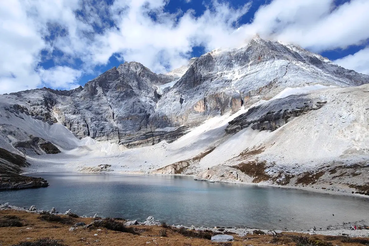
Yading's reputation needs no introduction. Usually, when visiting Yading, there are two accommodation options: Shangri-La Town and Yading Village. Shangri-La Town is about 7 kilometers from the new tourist service center, while Yading Village is inside the scenic area. Self-drive cars can only park at the tourist service center. After buying tickets, you enter the scenic area and take the shuttle bus. The shuttle bus arrives at Yading Village after about half an hour, stopping to pick up and drop off guests staying in the village. After about 45 minutes on the shuttle bus, you reach the final stop—Chonggu Temple. From Chonggu Temple, there are two routes: the short route walks to Pearl Sea; the long route takes an electric car to Luorong Pasture, then walks 12 li round trip to Milk Sea and Five-Color Sea. The 12-li walk is a true test of physical strength and willpower. We entered the scenic area at around 8 a.m. and exited at 6 p.m. Ten hours, except for the shuttle bus ride, all spent climbing. The weather did not disappoint us. The scenery was truly beautiful, but the exhaustion was real. However, after going through hellish training, it all felt worth it. I suggest visiting Milk Sea first, then Five-Color Sea. Although the distance is the same, it is slightly easier. For those at high altitude and with extreme physical limits, it saves a lot of energy. From Luorong Pasture, you can also ride a horse partway to Five-Color Sea and Milk Sea, but it's not recommended because: first, horses are few and have specific time slots; second, it's only one-way and doesn't reach Milk Sea or Five-Color Sea, so it only saves a few li. Most people take the long route in Yading, which generally takes about 6 hours round trip from Luorong Pasture to Milk Sea and Five-Color Sea. Adding the shuttle bus and such, 10 hours is quite normal for visiting Yading, so it's best to start early.
Pearl Sea, with the snow mountain behind being Xiannairi
From Xinduqiao to Litang, you pass through the famous 18 Bends of the Heavenly Road on National Highway 318. Above the 18 Bends, there is a viewing platform, parking lot, and restroom. Because too many people want to stop and view the 18 Bends, and the parking lot is not big enough, traffic jams often occur.
Yading — Litang
From Yading to Litang, we saw free roadside attractions all day. That's the advantage of self-driving: stopping and watching all along the way. From Yading to Litang, there are: Ten Thousand Mu Qinyang Forest, Zunsheng Stupa Complex, Red Grassland, Haizi Mountain, Rabbit Mountain, Wuliang River, and others. Then from Litang along National Highway 318 to Maoya Grassland and Sister Lakes.
Litang 318 National Highway check-in spot
From Xinduqiao to Tagong Grassland, we walked a scenic corridor. Small rivers, grasslands, green mountains, and trees accompanied us all the way. We arrived at noon. The sun was shining brightly, and it was very hot. Looking at the not-so-high uphill path, we really didn't want to climb. After staying in the parking lot for five minutes, we moved on to the next stop.
Bamei Moshi Park
It is the only plateau stone forest landscape in China, with unique scenery. The tour route is: first take the shuttle bus (now shuttle buses are a must for scenic spots and a main means of profiteering) to the top (only a few minutes, but costs 20 yuan), then walk along the wooden boardwalk, watching as you go. Finally, reach another exit, then take the shuttle bus back to the parking lot. Of course, you can also enter the scenic area from the exit parking lot, saving the shuttle bus fare, provided you are willing to walk a round trip. Moshi Park's scenery is somewhat worth seeing, but the road down to the exit is quite long.
In Bamei Town, when I got up in the morning, I encountered the first power outage of the trip. Pitch black, nothing could be done, and the electronic door lock wouldn't work properly. We had to wait for daylight.
A new scenic area. It has two main attractions: Yala Youcuo and Sister Lakes. The shuttle bus travels through the area, with beautiful surroundings, but does not stop. The 16-kilometer shuttle bus round trip costs 90 yuan, quite expensive. The onward journey can only be done on foot or by horse. The mountain roads are extremely poor, all gravel and dirt, definitely not suitable for walking in rain. Horse riding is priced in two segments: a long route to Sister Lakes and a short route to Yala Wetland. Yala Youcuo requires an additional mountain walk after reaching Yala Wetland. The highlight of the scenic area is Yala Youcuo. If the season is right and the weather cooperates, it is quite good. Sister Lakes are remote and the scenery is very ordinary, not recommended. The day we went was overcast, with occasional light rain and occasional precious sunlight—which appeared just when we were at Yala Youcuo, making the scenery much more beautiful. Incidentally, there was a power outage at the scenic area, so all payment systems were down and only cash was accepted. Luckily, we had prepared for it. Poor tourists behind us didn't have enough cash and couldn't enter.
Located in Aba County, Sichuan, it belongs to the same mountain system as Nianbao Yùzé in Qinghai, and the names are very similar. Nianbao Yùzé was closed in April 2018. So Lianbao Yèzé rose to prominence to replace it. The scenic area features unique peaks and strange rocks, snow mountains and lakes. Its biggest feature is that there is no shuttle bus, so unless you drive yourself, there is no other way. The ticket price is 120 yuan per person, expensive but worth it. The scenic area is extremely suitable for self-driving. The roads and parking lots are well-built and very close to the attractions, quite user-friendly. You can enjoy the beautiful scenery at high altitude with relatively little effort. I suggest stopping wherever you see a good place to park, and driving all the way to the highest point on the mountain! I guarantee it won't disappoint. Lianbao Yèzé is fully qualified to be called a paradise for self-driving tours.
13 kilometers from Aba county town. It has a history of over 200 years and is one of the three major Gelug sect monasteries. The monastery covers an area of 18,000 square meters, with stupas, scripture corridors, and prayer halls all complete, large in scale, and still under extensive construction. The Bodhi Great Stupa has seven floors, housing the relics of the Gelug founder Tsongkhapa. Unfortunately, due to the power outage, the elevator was not working and we couldn't find stairs, so we couldn't go upstairs to see it. We only had a look from outside and on the first floor. But it was still impressive!
The village is built along the mountain, peaceful and beautiful. It has won the title of "Most Beautiful Chinese Paradise." On our way from Aba County to Hongyuan County, we made a detour to visit. Surprisingly, there were no other tourists at all except us; the parking lot was completely empty. Because the Jiuma Expressway was under construction, the Wacha Ring Road we took was full of potholes from the heavy construction trucks, making it very difficult to drive.
The Red Army stayed here during the Long March—another red mark
Hongyuan Grassland Moon Bay
There are some viewing platforms along the Jiu-Hong Grassland Tourism Road where you can stop to see the magnificent grassland scenery. After seeing beautiful scenery all the way, we didn't have high expectations for Moon Bay. Since we had time and were passing by, we thought we'd have a look. The scenic area is not large and doesn't take much time. Same old routine: take a shuttle bus, then transfer to an electric car. The scenic area built a viewing tower with an elevator to the observation deck. Looking out from the height, the scenery was indeed good: the winding Bai River flowed below, the sky was vast, the fields boundless, and wind blew to reveal cattle and sheep grazing. Some travel notes say it's enough to see the Hongyuan Grassland from the road and that paying to see Moon Bay is not worth it. But I think looking from a height is different from free viewing platforms, so it's worth spending the money.
First Bend of the Yellow River
The confluence of the Bai River and the Yellow River forms the magnificent First Bend of the Yellow River. Taking a 13-stage escalator, you reach the observation deck. Looking around from the deck, the winding Yellow River is fully visible. This is also a place where the Red Army passed during the Long March. Looking at this vast land, thoughts recalled Mao Zedong's poem: "Ask the vast earth, who decides its rise and fall?"
From the First Bend of the Yellow River to Ruoergai Huahu, you must take the Tangre Road. The whole journey passes through the lush Ruoergai Grassland, with few vehicles and pleasant scenery.
At Ruoergai Huahu Scenic Area, you still have to take the shuttle bus; walking is not allowed. Once the shuttle bus arrives, you have to walk quite a long straight wooden boardwalk to reach the water. The day we went was clear, the sky high and clouds light. The water surface sparkled with golden light; clusters of water plants dotted the lake, making it very beautiful. Walking around the Huahu boardwalk takes about an hour and a half, with some viewing platforms perfect for photos and sightseeing.
Langmusi Town has two Langmusi temples, one in Gansu and one in Sichuan. The Gansu one is free, and the Sichuan one costs 20 yuan. To go to the source of the Bailong River and the Bailong River Grand Canyon behind Langmusi, we chose the Sichuan Langmusi. However, when we went, the Sichuan Langmusi was undergoing road construction, dusty and gray. After visiting the temple, we eagerly walked to the back. The area is basically undeveloped. The dirt road along the Bailong River Canyon had to cross the Bailong River (a small stream) frequently; the road was very difficult, and the scenery was ordinary. The Bailong River Grand Canyon is truly undeserving of its name. At this point, the Bailong River was just a few meters wide stream.
When we left Langmusi, it was an overcast day and there was another power outage. The streets were dim and deserted. We found a small restaurant for lunch. The owner immediately started a small generator to cook for us. This shows that power outages are common, and the impact of COVID-19 seems significant.
Road from Langmusi to Bailong River Grand Canyon
Tiebu Town Randuo Village
On the way from Langmusi to Zhagana, there is a very beautiful small village by the roadside, with a lovely poplar forest. A small river flows beside the forest. Parking and visiting are free. So some tour buses also stop here, making it a great place to take a break and check in.
Because of the route arrangement, we also visited Zhagana in Gansu on this trip. On the day we arrived, the epidemic had already emerged in western Sichuan and Yinchuan. When entering the scenic area, we encountered our first registration check. It seemed the COVID-19 infections were running ahead of us. Fortunately, the measures came after us. When we left the next day, it was said that the scenic area already required nucleic acid test reports. If we had to go to the county hospital for a test, we might as well skip it! Accommodation in Zhagana, from bottom to top: Dongwa Village, Yeri Village, Dari Village, Daiba Village. There are many viewing platforms and parking lots, allowing views of the entire Zhagana from different heights. Further up is the Locke Road, with endless mountain roads and desolate mountain scenery. The whole section was under construction, all unpaved roads.
Zhagana didn't seem as attractive as people say; it didn't meet expectations. Perhaps the weather was not ideal.
Mountain weather is unpredictable. In the middle of the night, light snow fell. When we got up in the morning, everything was white.
The day we arrived
The next morning
Shenxian Chi is called Nen'ensangcuo in Tibetan. It is about 40 kilometers from Jiuzhaigou. It claims to be a combination of Jiuzhaigou and Huanglong. It does have a bit of that flavor. But if you have already been to Jiuzhaigou and Huanglong, Shenxian Chi is not necessary. It is smaller and the scenery is a grade lower. Since you've already been to Jiuzhaigou and Huanglong, why bother with Shenxian? What surprised us was that the day we went was not a weekend, and the transportation to Shenxian Chi was not very convenient, yet there were quite many tourists. Was it because of good advertising?
The road from Shenxian Chi to Jiuzhaigou goes through 28 twists. I imagine drone aerial photography would be spectacular.
The first twist at the bottom
The 28th twist at the top, like two different worlds
After the August 8, 2017 earthquake, the scenic area was damaged and did not fully reopen until September 28, 2021. We were lucky to catch it. After buying tickets in the visitor hall, we entered the ticket gate and boarded the shuttle bus. Because there were many tourists, the first stop was arranged by the scenic area, not up to us. To stagger the visitors, the shuttle bus took us to Xiniu Lake. Jiuzhaigou Scenic Area is shaped like a Y. The midpoint is Nuorilang, the tourist center for dining, shopping, resting, and transferring. One branch of the Y goes to Changhai, the other to Primeval Forest. Many attractions are scattered along them. Suggestions: you can skip the Primeval Forest and just walk back from Fangcao Lake. This was my second visit to Jiuzhaigou. This time, I felt the scenic area had made efforts; the attractions were well restored. As for the scenery, there's no doubt. At any time, Jiuzhaigou is beautiful and worth visiting.
Because of bad weather, the experience was very poor. Whether to take the cable car up the mountain was a dilemma. If you take the cable car, you spend money, queue, and still have to walk a lot. That long section had no scenery. If you don't take the cable car, walking round trip doesn't seem worth it either. The scenery depends on the weather and personal feeling. The day we went was really not good. The 170 yuan ticket and the 80 yuan cable car were a bit of a rip-off. I think Huanglong's cable car is the most unreasonable cable car I have ever taken, without exception.
The scenic area consists of two parts: Erdaohai and Zhaga Waterfall, about 20 kilometers apart. Due to its remote location, there are few tourists. You can buy a combined ticket. Mounigou is famous for its travertine pools, primeval forest, and alpine meadows. Erdaohai is well-developed with a full wooden boardwalk. Many attractions and nice scenery, worth a visit. Zhaga Waterfall is much smaller, basically only one waterfall to see. If time is limited, you can skip it.
Expressways are not well developed in western Sichuan. Since Hailuogou, we had been circling a large area in western Sichuan. Only on the way from Mao County to Bipenggou did we get on the expressway that winds among the mountains in Wenchuan. Looking at the towering mountains around, I couldn't help but feel frightened. Bipenggou is only 200 kilometers from Chengdu, and it happened to be a weekend, so there were many self-driving tourists. Even entering the parking lot required queuing. The tour method: first take the shuttle bus to Longwanghai, then walk through the lake area, then take the shuttle bus again to the tourist service center. At the service center, take an electric car to Panyang Lake, the highlight of the scenic area. From Panyang Lake, you can also take an electric car to Yanziwo. Due to time constraints, we didn't go to Yanziwo. Instead, after visiting Panyang Lake, we walked back to the tourist service center along the trail. Finally, we took the shuttle bus back to the main entrance. October is supposedly the most beautiful season for Bipenggou, with snow mountains, lakes, and poplar trees complementing each other. Compared to the 130 yuan ticket, it was good value for money.
The day we went to Siguniang Mountain was the tightest schedule. But everything seemed to make us slow. First, the hotel breakfast didn't start until 8 a.m., already half an hour later than planned. And visiting Bipenggou took a lot of time. So, when we reached the Balang Mountain winding road, night had fallen, and rain and fog struck simultaneously, greatly reducing visibility. For safety, we drove at a snail's pace. The most annoying thing was when we were only a few kilometers away from our guesthouse, we were stuck in a traffic jam due to health code checking for the epidemic. That little thing made us queue for a full hour.
Siguniang Mountain Scenic Area has three attractions: Shuangqiaogou, Changpinggou, and Haizigou, each sold separately. We visited Shuangqiaogou and Changpinggou.
Shuangqiaogou is a large scenic area. The tour method is simple: the shuttle bus takes you all the way to the farthest point, then you visit station by station on the way back. It has forests, small lakes, and meadows, but no Siguniang Mountain! It was our ignorance; Shuangqiaogou does not offer views of Siguniang Mountain at all.
Changpinggou: take a shuttle bus from the ticket office to the entrance of the scenic area, then the entire tour is on foot or horseback. More accurately named than Shuangqiaogou, you can see the Yaomei Peak of Siguniang Mountain right at the entrance. The wooden boardwalk goes all the way, reportedly becoming more beautiful the farther you go. Unfortunately, due to time constraints, we only reached the Withered Tree Beach. Under the setting sun, the woods, peaks, and stream were quite nice.
The best spot to see Siguniang Mountain is said to be the Maobiliang Viewing Platform by the roadside. We passed by when we left, but due to bad weather, we couldn't see the mountain. Throughout the entire Siguniang Mountain trip, we never saw the complete mountain. It seemed we had nothing to do with Siguniang Mountain.
Soon after passing Maobiliang, we were back on the Balang Mountain road. It had snowed lightly the night before, so everything was white, but luckily the snow was shallow. Since it was daytime, driving was easier than the night rain and fog. Just a little caution. After descending Balang Mountain, all traces of snow disappeared. Soon, we got on the expressway—full speed back to Shanghai.
Maobiliang Viewing Platform
Nothing could be seen from the Balang Mountain viewing platform
On October 26, we set off from Siguniang Mountain to return to Shanghai. At that time, there was an outbreak in Chengdu, and returning via Chengdu required nucleic acid testing and daily temperature reporting. We luckily bypassed Chengdu, passing through Qu County, Dangyang, and Anqing, and returned to Shanghai on October 29. The Sichuan self-drive trip ended smoothly. The heavens were very kind to us. Although we brushed past COVID-19 in Ruoergai Huahu and Zhagana, it had no impact on us.
Every trip, weather plays a decisive role in the scenery. There are many beautiful scenic spots in Sichuan. This self-drive tour only visited some of them. If I had to choose among these, the most worthwhile are: Yading, Lianbao Yèzé, and Jiuzhaigou.
This year, the epidemic still occurs sporadically across the country. And we in Shanghai experienced the most painful lockdown, spending the entire spring shut in at home, doing nothing but nucleic acid tests and writing this random note out of boredom.
After a long 70 days, life began to gradually return to normal from June 1. I wonder, with the strict epidemic prevention measures nationwide, whether I will have the chance to continue my self-drive journey this autumn.
June 1, 2022